Morris, Wisconsin
Submit your own pictures of this town and show them to the world
- OSM Map
- Google Map
- MSN Map
Population change since 2000: -6.6%
 |
| Males: 242 | |
| Females: 211 |
| Median resident age: | 46.3 years |
| Wisconsin median age: | 42.6 years |
Zip codes: 54486.
| Morris: | $62,159 |
| WI: | $70,996 |
Estimated per capita income in 2022: $28,354 (it was $14,627 in 2000)
Morris town income, earnings, and wages data
Estimated median house or condo value in 2022: $194,632 (it was $91,800 in 2000)
| Morris: | $194,632 |
| WI: | $252,800 |
Mean prices in 2022: all housing units: $252,779; detached houses: $260,048; townhouses or other attached units: $236,747; in 2-unit structures: $259,922; in 3-to-4-unit structures: $163,894; in 5-or-more-unit structures: $365,963; mobile homes: $107,650
Detailed information about poverty and poor residents in Morris, WI
Compare current foreclosures near Morris, WI:
| Photo | Address | Area | Beds / Baths | Price | Details |
|---|---|---|---|---|---|

|
#1
W Town Hall Rd
Gresham, WI 54128
|
- sq. feet
|
1 baths 3 beds |
show details | |

|
#2
Wittmor Townline Rd
Wittenberg, WI 54499
|
- sq. feet
|
- baths - beds |
show details | |

|
#3
County Road A
Bowler, WI 54416
|
- sq. feet
|
- baths - beds |
show details | |

|
#4
Main St
Tigerton, WI 54486
|
- sq. feet
|
- baths - beds |
show details | |

|
#5
State Highway 49
Eland, WI 54427
|
- sq. feet
|
- baths - beds |
show details | |

|
#6
3rd St
Leopolis, WI 54948
|
- sq. feet
|
- baths - beds |
show details | |

|
#7
Park St # 5
Gresham, WI 54128
|
- sq. feet
|
- baths - beds |
show details | |

|
#8
North Ave
Birnamwood, WI 54414
|
- sq. feet
|
- baths - beds |
show details | |

|
#9
4th St
Mattoon, WI 54450
|
- sq. feet
|
- baths - beds |
show details | |

|
#10
State Highway 29
Shawano, WI 54166
|
- sq. feet
|
- baths - beds |
show details |
| Photo | Address | Area | Beds / Baths | Price | Details |
|---|---|---|---|---|---|

|
#11
N Shore Dr
Hatley, WI 54440
|
- sq. feet
|
- baths - beds |
show details | |

|
#12
S Rollwood Rd
Antigo, WI 54409
|
- sq. feet
|
- baths - beds |
show details | |

|
#13
S Ellms St
Wittenberg, WI 54499
|
- sq. feet
|
- baths - beds |
show details | |

|
#14
S Main St # B
Marion, WI 54950
|
- sq. feet
|
- baths - beds |
show details | |

|
#15
S Main St
Marion, WI 54950
|
- sq. feet
|
- baths - beds |
show details | |

|
#16
County Road A
Rosholt, WI 54473
|
- sq. feet
|
- baths - beds |
show details | |

|
Check over 1 million property listings on Foreclosure.com!
|
browse all offers | |||

- 42694.0%White alone
- 163.5%American Indian alone
- 81.8%Hispanic
- 30.7%Two or more races

Races in Morris detailed stats: ancestries, foreign born residents, place of birth
 Recent articles from our blog. Our writers, many of them Ph.D. graduates or candidates, create easy-to-read articles on a wide variety of topics.
Ancestries: German (64.1%), French (13.0%), Norwegian (9.9%), Polish (9.3%), Irish (7.0%), English (4.7%).
Current Local Time: CST time zone
Land area: 36.2 square miles.
Population density: 13 people per square mile (very low).
13 residents are foreign born (1.9% Europe, 0.4% Asia, 0.4% Africa).
| This town: | 2.7% |
| Wisconsin: | 3.6% |
| Morris town: | 1.2% ($1,140) |
| Wisconsin: | 2.0% ($2,245) |
Nearest city with pop. 50,000+: Appleton, WI  (49.9 miles , pop. 70,087).
Nearest city with pop. 200,000+: Madison, WI (122.2 miles , pop. 208,054).
Nearest city with pop. 1,000,000+: Chicago, IL (217.4 miles , pop. 2,896,016).
Nearest cities:
), ), ), ), ), )Latitude: 44.82 N, Longitude: 89.05 W
Area code commonly used in this area: 715

| Here: | 2.9% |
| Wisconsin: | 2.7% |

- Agriculture, forestry, fishing & hunting (11.2%)
- Health care (10.1%)
- Metal & metal products (9.4%)
- Educational services (9.0%)
- Wood products (6.5%)
- Accommodation & food services (6.1%)
- Construction (5.0%)

- Agriculture, forestry, fishing & hunting (12.4%)
- Metal & metal products (12.4%)
- Construction (9.7%)
- Wood products (8.3%)
- Transportation equipment (6.9%)
- Educational services (6.9%)
- Motor vehicle & parts dealers (3.4%)

- Health care (20.3%)
- Educational services (11.3%)
- Accommodation & food services (10.5%)
- Agriculture, forestry, fishing & hunting (9.8%)
- Metal & metal products (6.0%)
- Finance & insurance (5.3%)
- Wood products (4.5%)

- Nursing, psychiatric, and home health aides (6.8%)
- Farmers and farm managers (5.8%)
- Driver/sales workers and truck drivers (4.7%)
- Preschool, kindergarten, elementary, and middle school teachers (4.3%)
- Other production occupations, including supervisors (4.3%)
- Agricultural workers, including supervisors (4.0%)
- Metal workers and plastic workers (4.0%)

- Driver/sales workers and truck drivers (9.0%)
- Farmers and farm managers (7.6%)
- Metal workers and plastic workers (7.6%)
- Assemblers and fabricators (6.2%)
- Other production occupations, including supervisors (6.2%)
- Laborers and material movers, hand (6.2%)
- Electrical equipment mechanics and other installation, maintenance, and repair workers, including supervisors (5.5%)

- Nursing, psychiatric, and home health aides (9.8%)
- Financial clerks, except bookkeeping, accounting and auditing clerks (5.3%)
- Registered nurses (4.5%)
- Cooks and food preparation workers (4.5%)
- Supervisors and other personal care and service workers, except child care workers (4.5%)
- Secretaries and administrative assistants (4.5%)
- Preschool, kindergarten, elementary, and middle school teachers (3.8%)
Average climate in Morris, Wisconsin
Based on data reported by over 4,000 weather stations


Tornado activity:
Morris-area historical tornado activity is near Wisconsin state average. It is 2% greater than the overall U.S. average.
On 9/26/1951, a category F4 (max. wind speeds 207-260 mph) tornado 27.7 miles away from the Morris town center killed 6 people and injured 3 people and caused between $50,000 and $500,000 in damages.
On 6/7/2007, a category F3 (max. wind speeds 158-206 mph) tornado 13.1 miles away from the town center injured 3 people and caused $15 million in damages.
Earthquake activity:
Morris-area historical earthquake activity is significantly above Wisconsin state average. It is 80% smaller than the overall U.S. average.On 6/28/2004 at 06:10:52, a magnitude 4.2 (4.2 MW, Depth: 6.2 mi, Class: Light, Intensity: IV - V) earthquake occurred 232.7 miles away from the city center
On 5/2/2015 at 16:23:07, a magnitude 4.2 (4.2 MW, Depth: 2.8 mi) earthquake occurred 254.8 miles away from Morris center
On 2/10/2010 at 09:59:35, a magnitude 3.8 (3.8 MW, Depth: 6.2 mi, Class: Light, Intensity: II - III) earthquake occurred 199.3 miles away from the city center
On 7/9/1975 at 14:54:15, a magnitude 4.6 (4.6 MB) earthquake occurred 345.6 miles away from the city center
On 1/31/1986 at 16:46:43, a magnitude 5.0 (5.0 MB, Class: Moderate, Intensity: VI - VII) earthquake occurred 455.4 miles away from Morris center
On 7/12/1986 at 08:19:37, a magnitude 4.5 (4.5 MB) earthquake occurred 379.8 miles away from the city center
Magnitude types: body-wave magnitude (MB), moment magnitude (MW)
Natural disasters:
The number of natural disasters in Shawano County (7) is smaller than the US average (15).Major Disasters (Presidential) Declared: 4
Emergencies Declared: 2
Causes of natural disasters: Floods: 4, Storms: 4, Tornadoes: 3, Drought: 1, Hurricane: 1, Wind: 1, Other: 1 (Note: some incidents may be assigned to more than one category).
Colleges/universities with over 2000 students nearest to Morris:
- Northcentral Technical College (about 32 miles; Wausau, WI; Full-time enrollment: 3,356)
- University of Wisconsin-Stevens Point (about 33 miles; Stevens Point, WI; FT enrollment: 9,089)
- Mid-State Technical College (about 48 miles; Wisconsin Rapids, WI; FT enrollment: 2,128)
- Fox Valley Technical College (about 48 miles; Appleton, WI; FT enrollment: 5,682)
- Lawrence University (about 51 miles; Appleton, WI; FT enrollment: 2,821)
- Northeast Wisconsin Technical College (about 51 miles; Green Bay, WI; FT enrollment: 6,069)
- Saint Norbert College (about 55 miles; De Pere, WI; FT enrollment: 2,324)
Points of interest:
Church in Morris: Immanuel Church (A). Display/hide its location on the map
Creeks: Wilson Creek (A), Dent Creek (B), Simpson Creek (C). Display/hide their locations on the map
| This town: | 2.4 people |
| Wisconsin: | 2.4 people |
| This town: | 75.3% |
| Whole state: | 64.4% |
| This town: | 6.3% |
| Whole state: | 7.3% |
No gay or lesbian households reported
| This town: | 17.6% |
| Whole state: | 8.7% |
| This town: | 3.9% |
| Whole state: | 3.7% |
For population 15 years and over in Morris:

- Never married: 21.4%
- Now married: 60.6%
- Separated: 2.3%
- Widowed: 6.2%
- Divorced: 9.4%
For population 25 years and over in Morris:
- High school or higher: 80.6%
- Bachelor's degree or higher: 11.0%
- Graduate or professional degree: 3.4%
- Unemployed: 1.8%
- Mean travel time to work (commute): 27.7 minutes


| Here: | 10.8 |
| Wisconsin average: | 11.0 |
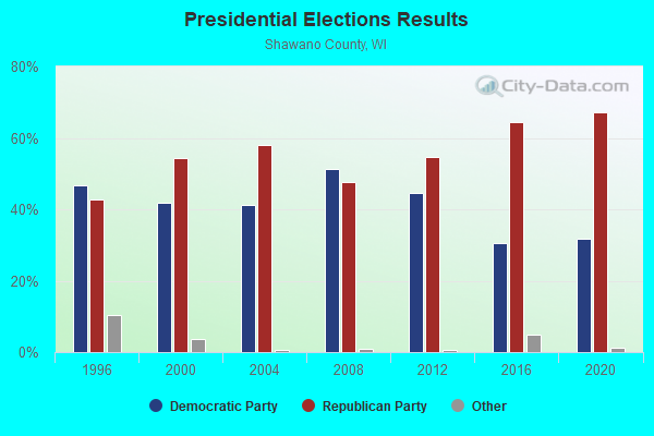
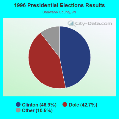
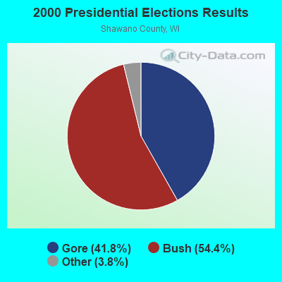
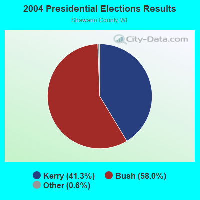
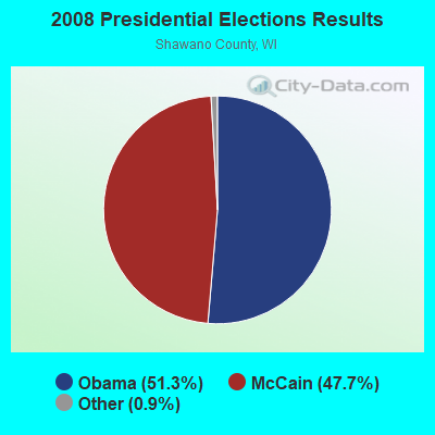

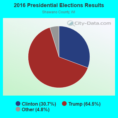
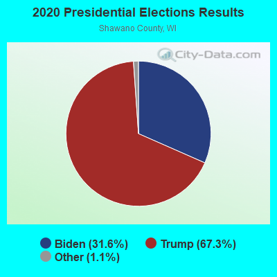
Graphs represent county-level data. Detailed 2008 Election Results
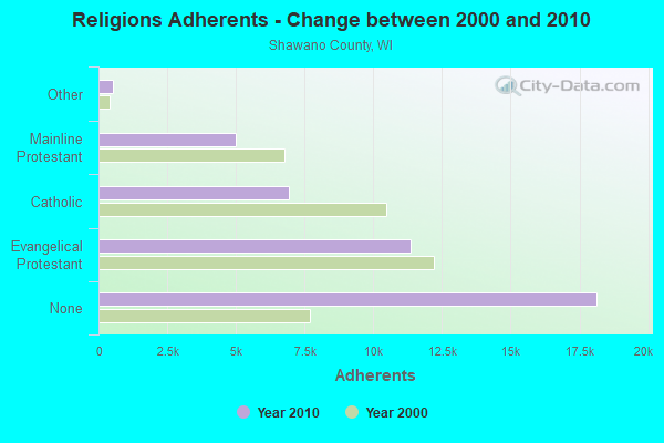
Religion statistics for Morris, WI (based on Shawano County data)
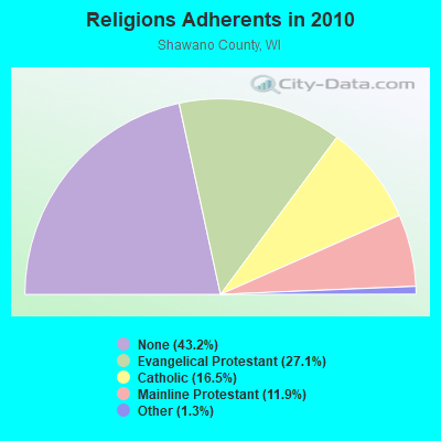
| Religion | Adherents | Congregations |
|---|---|---|
| Evangelical Protestant | 11,357 | 43 |
| Catholic | 6,930 | 12 |
| Mainline Protestant | 4,995 | 23 |
| Other | 527 | 3 |
| None | 18,140 | - |
Food Environment Statistics:
| Shawano County: | 2.44 / 10,000 pop. |
| Wisconsin: | 1.86 / 10,000 pop. |
| Shawano County: | 0.24 / 10,000 pop. |
| Wisconsin: | 0.11 / 10,000 pop. |
| This county: | 7.57 / 10,000 pop. |
| Wisconsin: | 4.12 / 10,000 pop. |
| Here: | 11.72 / 10,000 pop. |
| Wisconsin: | 8.64 / 10,000 pop. |
| Shawano County: | 8.9% |
| State: | 7.6% |
| This county: | 28.1% |
| Wisconsin: | 27.5% |
| This county: | 11.0% |
| State: | 13.0% |
Strongest AM radio stations in Morris:
- WSAU (550 AM; 20 kW; WAUSAU, WI; Owner: WRIG, INC.)
- WSPT (1010 AM; 50 kW; STEVENS POINT, WI)
- WNAM (1280 AM; 50 kW; NEENAH-MENASHA, WI; Owner: CUMULUS LICENSING CORP.)
- WRIG (1390 AM; 10 kW; SCHOFIELD, WI; Owner: WRIG, INC.)
- WHBY (1150 AM; 25 kW; KIMBERLY, WI; Owner: WOODWARD COMMUNICATIONS, INC.)
- WDUX (800 AM; 5 kW; WAUPACA, WI; Owner: LAIRD BROADCASTING COMPANY, INC.)
- WFCL (1380 AM; 4 kW; CLINTONVILLE, WI; Owner: RESULTS BROADCASTING CORP.)
- WTMJ (620 AM; 50 kW; MILWAUKEE, WI; Owner: JOURNAL BROADCAST CORPORATION)
- WTAQ (1360 AM; 10 kW; GREEN BAY, WI; Owner: MIDWEST COMMUNICATIONS, INC.)
- WTCH (960 AM; 1 kW; SHAWANO, WI; Owner: RESULTS BROADCASTING OF SHAWANO, INC.)
- WEBC (560 AM; 50 kW; DULUTH, MN)
- WTCM (580 AM; 35 kW; TRAVERSE CITY, MI; Owner: WTCM RADIO, INC.)
- WLBL (930 AM; 5 kW; AUBURNDALE, WI; Owner: STATE OF WISCONSIN - EDUCATIONAL COMMUNICATIONS BOARD)
Strongest FM radio stations in Morris:
- WYCO (107.9 FM; WAUSAU, WI; Owner: SEEHAFER BROADCASTING CORPORATION)
- WHRM (90.9 FM; WAUSAU, WI; Owner: STATE OF WISCONSIN - EDUCATIONAL COMMUNICATIONS BOARD)
- WIFC (95.5 FM; WAUSAU, WI; Owner: WRIG, INC.)
- WDEZ (101.9 FM; WAUSAU, WI; Owner: W R I G, INC.)
- WYNW (92.9 FM; BIRNAMWOOD, WI; Owner: STARBOARD BROADCASTING, INC.)
- WRVM (102.7 FM; SURING, WI; Owner: WRVM, INC.)
- WLBL-FM (91.9 FM; WAUSAU, WI; Owner: STATE OF WISCONSIN - EDUCATIONAL COMMUNICATIONS BOARD)
- WXPW (91.9 FM; WAUSAU, WI; Owner: WHITE PINE COMMUNITY BROADCASTING, INC)
- WRLO-FM (105.3 FM; ANTIGO, WI; Owner: NEWRADIO GROUP, LLC)
- WCLQ (89.5 FM; WAUSAU, WI; Owner: CHRISTIAN LIFE COMMUNICATIONS, INC.)
- WHDG (97.5 FM; RHINELANDER, WI; Owner: RAVEN BROADCASTING CORPORATION)
- WOZZ (93.5 FM; NEW LONDON, WI; Owner: MIDWEST COMMUNICATIONS, INC)
- WACD (106.1 FM; ANTIGO, WI; Owner: NEWRADIO GROUP, LLC)
- WJMQ (92.3 FM; CLINTONVILLE, WI; Owner: RESULTS BROADCASTING CORP.)
TV broadcast stations around Morris:
- WFXS (Channel 55; WITTENBERG, WI; Owner: DAVIS TELEVISION WAUSAU, LLC)
- W24BV (Channel 24; WHITING, WI; Owner: MS COMMUNICATIONS, LLC)
- WIWB (Channel 14; SURING, WI; Owner: ACME TV LICENSES OF WISCONSIN, LLC)
- WYOW (Channel 34; EAGLE RIVER, WI; Owner: WAOW-WYOW TELEVISION, INC.)
- WAOW-TV (Channel 9; WAUSAU, WI; Owner: WAOW-WYOW TELEVISION, INC.)
- WSAW-TV (Channel 7; WAUSAU, WI; Owner: GRAY MIDAMERICA TV LICENSEE CORP.)
- WTPX (Channel 46; ANTIGO, WI; Owner: PAXSON WAUSAU LICENSE, INC.)
- W04CW (Channel 4; TIGERTON, ETC., WI; Owner: CENTRAL AUTOMATIC MACHINING, INC.)
- W60CI (Channel 60; WHITING, WI; Owner: MS COMMUNICATIONS, LLC)
- WHRM-TV (Channel 20; WAUSAU, WI; Owner: STATE OF WISCONSIN - EDUCATIONAL COMMUNICATIONS BOARD)
- W66DC (Channel 66; WAUPACA, WI; Owner: TRINITY BROADCASTING NETWORK)
- National Bridge Inventory (NBI) Statistics
- 11Number of bridges
- 72ft / 22.0mTotal length
- $509,000Total costs
- 10,276Total average daily traffic
- 315Total average daily truck traffic
- 21,613Total future (year 2039) average daily traffic

- New bridges - historical statistics
- 11930-1939
- 11940-1949
- 11950-1959
- 21960-1969
- 41980-1989
- 11990-1999
- 12010-2019
FCC Registered Cell Phone Towers:
1- Intersection Of Highway 29 & Tower Lane (Lat: 44.822472 Lon: -89.060389), Structure height: 59.2 m, Call Sign: KNKN395
Assigned Frequencies: 880.020 MHz, 891.510 MHz, 835.020 MHz, 846.510 MHzGrant Date: 08/27/2019, Expiration Date: 10/01/2029, Certifier: Mark NazeRegistrant: Lukas, Lafuria, Lantor & Sachs, LLP, 8350 Broad Street, Suite 1450, Tysons, VA 22102, Phone: (703) 584-8673, Fax: (301) 622-2864, Email:
FCC Registered Microwave Towers:
1- TRUCKERS HIL, Cor Of Hwy 29 And Tower Ln (Lat: 44.822472 Lon: -89.060333), Structure height: 54.9 m, Overall height: 60.7 m, Call Sign: WPNG871,
Assigned Frequencies: 11545.0 MHz, Grant Date: 02/21/2001, Expiration Date: 02/01/2011, Cancellation Date: 11/17/2008, Registrant: Hill & Welch, 1330 New Hampshire Ave., Nw #113, Washington, DC 20036, Phone: (202) 775-0070, Fax: (202) 775-9026, Email:

- 38.9%Wood
- 33.3%Bottled, tank, or LP gas
- 23.5%Fuel oil, kerosene, etc.
- 2.5%Electricity
- 1.2%No fuel used
- 0.6%Utility gas

- 31.2%Bottled, tank, or LP gas
- 28.1%Fuel oil, kerosene, etc.
- 18.8%Wood
- 15.6%Utility gas
- 6.2%Electricity
Morris compared to Wisconsin state average:
- Unemployed percentage significantly below state average.
- Black race population percentage significantly below state average.
- Hispanic race population percentage significantly below state average.
- Foreign-born population percentage below state average.
- Renting percentage significantly below state average.
- Length of stay since moving in significantly above state average.
- Number of rooms per house significantly below state average.
- House age significantly below state average.
- Number of college students below state average.
- Percentage of population with a bachelor's degree or higher below state average.