Skyline, Oregon
Submit your own pictures of this place and show them to the world
- OSM Map
- General Map
- Google Map
- MSN Map

| Males: 1,643 | |
| Females: 1,434 |
| Median resident age: | 44.4 years |
| Oregon median age: | 36.3 years |
Zip code: 97231
| Skyline: | $119,018 |
| OR: | $75,657 |
Estimated per capita income in 2022: $84,177 (it was $38,169 in 2000)
Skyline CCD income, earnings, and wages data
Estimated median house or condo value in 2022: $879,133 (it was $258,200 in 2000)
| Skyline: | $879,133 |
| OR: | $475,600 |
Mean prices in 2022: all housing units: $569,269; detached houses: $596,986; townhouses or other attached units: $471,196; in 2-unit structures: $613,637; in 3-to-4-unit structures: $545,719; in 5-or-more-unit structures: $483,392; mobile homes: $108,614; occupied boats, rvs, vans, etc.: $581,896
Detailed information about poverty and poor residents in Skyline, OR
Compare current foreclosures near Skyline, OR:
| Photo | Address | Area | Beds / Baths | Price | Details |
|---|---|---|---|---|---|

|
#1
SW 1st Ave Apt 2125
Portland, OR 97201
|
1,950 sq. feet
|
2 baths 3 beds |
$695,000
|
show details |

|
#2
NE 121st Ave Apt E27
Vancouver, WA 98682
|
1,078 sq. feet
|
2 baths 2 beds |
show details | |

|
#3
W Burnside Rd Unit 527
Portland, OR 97210
|
1,288 sq. feet
|
2 baths 2 beds |
show details | |

|
#4
Bird Rd
Scappoose, OR 97056
|
11 sq. feet
|
- baths - beds |
$105,000
|
show details |

|
#5
SW Fradeen Ln
Portland, OR 97225
|
4,684 sq. feet
|
4 baths 3 beds |
show details | |

|
#6
NW Irving St Apt 320
Portland, OR 97209
|
- sq. feet
|
1 baths 1 beds |
show details | |

|
#7
SW Bellavista Ct
Beaverton, OR 97007
|
4,064 sq. feet
|
2 baths 3 beds |
show details | |

|
#8
NW 126th St
Vancouver, WA 98685
|
2,366 sq. feet
|
2 baths 4 beds |
show details | |

|
#9
NW Broadshire Ln
Banks, OR 97106
|
1,849 sq. feet
|
3 baths 3 beds |
show details | |

|
#10
NE 96th Ave
Vancouver, WA 98662
|
1,270 sq. feet
|
2 baths 3 beds |
show details |
| Photo | Address | Area | Beds / Baths | Price | Details |
|---|---|---|---|---|---|

|
#11
Ne80th St
Vancouver, WA 98682
|
1,591 sq. feet
|
2 baths 3 beds |
show details | |

|
#12
Alder Creek Rd
Scappoose, OR 97056
|
1,344 sq. feet
|
2 baths 3 beds |
show details | |

|
#13
N 10th St
Saint Helens, OR 97051
|
1,223 sq. feet
|
2 baths 3 beds |
show details | |

|
#14
NE 49th St
Vancouver, WA 98661
|
1,928 sq. feet
|
2 baths 3 beds |
show details | |

|
#15
NE 69th St
Vancouver, WA 98662
|
960 sq. feet
|
1 baths 3 beds |
show details | |

|
#16
NE 111th St
Vancouver, WA 98686
|
2,015 sq. feet
|
2 baths 4 beds |
show details | |

|
#17
NE Holman St
Portland, OR 97218
|
1,272 sq. feet
|
2 baths 2 beds |
show details | |

|
#18
NE Liberty Ct
Portland, OR 97211
|
2,257 sq. feet
|
3 baths 3 beds |
show details | |

|
#19
SE Spruce St
Hillsboro, OR 97123
|
2,026 sq. feet
|
2 baths 3 beds |
show details | |

|
#20
SE 16th Ave
Hillsboro, OR 97123
|
1,044 sq. feet
|
2 baths 4 beds |
show details |
| Photo | Address | Area | Beds / Baths | Price | Details |
|---|---|---|---|---|---|

|
#21
NW Nelscott St
Portland, OR 97229
|
1,503 sq. feet
|
2 baths 3 beds |
show details | |

|
#22
NE 77th Ave
Vancouver, WA 98664
|
1,094 sq. feet
|
2 baths 2 beds |
show details | |

|
#23
O St
Vancouver, WA 98663
|
784 sq. feet
|
1 baths 1 beds |
show details | |

|
#24
NE Anna Ave
Hillsboro, OR 97124
|
2,900 sq. feet
|
3 baths 5 beds |
show details | |

|
#25
SW Meadow St
Portland, OR 97223
|
- sq. feet
|
1 baths 3 beds |
show details | |

|
#26
SW Audubon St Unit 103
Beaverton, OR 97003
|
- sq. feet
|
2 baths 2 beds |
show details | |

|
#27
NE Morrow Rd
Vancouver, WA 98682
|
1,808 sq. feet
|
2 baths 5 beds |
show details | |

|
#28
Carlson Rd
Vancouver, WA 98661
|
1,032 sq. feet
|
1 baths 3 beds |
show details | |

|
#29
NE 135th Ave
Vancouver, WA 98682
|
2,036 sq. feet
|
2 baths 4 beds |
show details | |

|
#30
SW Cascadia St
Beaverton, OR 97078
|
- sq. feet
|
2 baths 3 beds |
show details |
| Photo | Address | Area | Beds / Baths | Price | Details |
|---|---|---|---|---|---|

|
#31
N Seward Ave
Portland, OR 97217
|
2,104 sq. feet
|
2 baths 3 beds |
show details | |

|
#32
NW Kathleen Dr
Portland, OR 97229
|
2,798 sq. feet
|
2 baths 4 beds |
show details | |

|
#33
NE 66th St
Vancouver, WA 98662
|
2,610 sq. feet
|
2 baths 4 beds |
show details | |

|
#34
SW Ludwig St
Beaverton, OR 97007
|
3,144 sq. feet
|
3 baths 7 beds |
show details | |

|
#35
SE Brookwood Ave Apt 111
Hillsboro, OR 97123
|
- sq. feet
|
2 baths 3 beds |
show details | |

|
#36
NE Mallory Ave
Portland, OR 97211
|
2,118 sq. feet
|
2 baths 5 beds |
show details | |

|
#37
NE 85th Cir
Vancouver, WA 98662
|
1,635 sq. feet
|
1 baths 3 beds |
show details | |

|
#38
NE Kathryn St
Hillsboro, OR 97124
|
1,820 sq. feet
|
2 baths 4 beds |
show details | |

|
#39
Ne133rd Ave
Vancouver, WA 98682
|
- sq. feet
|
2 baths 3 beds |
show details | |

|
#40
Grey Cliffs Ct
Saint Helens, OR 97051
|
1,056 sq. feet
|
1 baths 3 beds |
show details |
| Photo | Address | Area | Beds / Baths | Price | Details |
|---|---|---|---|---|---|

|
#41
NE 16th St
Vancouver, WA 98664
|
- sq. feet
|
2 baths 3 beds |
show details | |

|
#42
NE Darby St
Hillsboro, OR 97124
|
1,876 sq. feet
|
2 baths 5 beds |
show details | |

|
#43
SE Brookwood Ave
Hillsboro, OR 97123
|
2,538 sq. feet
|
2 baths 3 beds |
show details | |

|
#44
SW Wilbard St
Portland, OR 97219
|
1,400 sq. feet
|
2 baths 5 beds |
show details | |

|
#45
NE 27th Ave
Portland, OR 97211
|
1,190 sq. feet
|
1 baths 4 beds |
show details | |

|
#46
Ne82nd Street
Vancouver, WA 98662
|
- sq. feet
|
1 baths 3 beds |
show details | |

|
#47
N 11th St
Saint Helens, OR 97051
|
928 sq. feet
|
1 baths 2 beds |
show details | |

|
#48
NW 10th St
Battle Ground, WA 98604
|
1,410 sq. feet
|
2 baths 3 beds |
show details | |

|
#49
SW Perfecta Ave
Beaverton, OR 97005
|
1,552 sq. feet
|
2 baths 3 beds |
show details | |

|
Check over 1 million property listings on Foreclosure.com!
|
browse all offers | |||

- 2,59588.8%White alone
- 1635.6%Hispanic
- 501.7%American Indian alone
- 441.5%Two or more races
- 401.4%Asian alone
- 160.5%Other race alone
- 80.3%Native Hawaiian and Other
Pacific Islander alone - 60.2%Black alone

Races in Skyline detailed stats: ancestries, foreign born residents, place of birth
 Recent articles from our blog. Our writers, many of them Ph.D. graduates or candidates, create easy-to-read articles on a wide variety of topics.
Current Local Time: PST time zone
Land area: 51.5 square miles.
Population density: 60 people per square mile (very low).

| Skyline CCD: | 0.8% ($2,175) |
| Oregon: | 1.2% ($1,687) |
Nearest city with pop. 50,000+: Somerset West-Rock Creek, OR (8.8 miles  , pop. 53,691).
Nearest city with pop. 200,000+: Portland, OR (14.9 miles , pop. 529,121).
Nearest city with pop. 1,000,000+: Los Angeles, CA (835.4 miles , pop. 3,694,820).
Nearest cities:
), ), ), ), ), )Latitude: 45.67 N, Longitude: 122.87 W
Area code commonly used in this area: 503


| Here: | 3.7% |
| Oregon: | 3.9% |

- Construction (11.0%)
- Health care (8.4%)
- Professional, scientific, technical services (8.0%)
- Educational services (7.7%)
- Public administration (5.9%)
- Computer & electronic products (4.8%)
- Agriculture, forestry, fishing & hunting (4.3%)

- Construction (18.0%)
- Professional, scientific, technical services (6.0%)
- Public administration (5.7%)
- Agriculture, forestry, fishing & hunting (5.2%)
- Computer & electronic products (4.3%)
- Health care (4.3%)
- Educational services (4.1%)

- Health care (13.8%)
- Educational services (12.5%)
- Professional, scientific, technical services (10.6%)
- Finance & insurance (6.3%)
- Public administration (6.0%)
- Computer & electronic products (5.3%)
- Agriculture, forestry, fishing & hunting (3.2%)

- Other management occupations, except farmers and farm managers (8.1%)
- Other sales and related occupations, including supervisors (4.1%)
- Sales representatives, services, wholesale and manufacturing (3.1%)
- Computer specialists (3.0%)
- Retail sales workers, except cashiers (2.7%)
- Registered nurses (2.6%)
- Engineers (2.5%)

- Other management occupations, except farmers and farm managers (9.3%)
- Other sales and related occupations, including supervisors (4.4%)
- Engineers (4.3%)
- Building and grounds cleaning and maintenance occupations (3.9%)
- Retail sales workers, except cashiers (3.8%)
- Supervisors, construction and extraction workers (3.5%)
- Construction traders workers except carpenters, electricians, painters, plumbers, and construction laborers (3.5%)

- Other management occupations, except farmers and farm managers (6.6%)
- Secretaries and administrative assistants (4.9%)
- Other office and administrative support workers, including supervisors (4.9%)
- Registered nurses (4.6%)
- Accountants and auditors (4.3%)
- Sales representatives, services, wholesale and manufacturing (3.9%)
- Computer specialists (3.7%)
Average climate in Skyline, Oregon
Based on data reported by over 4,000 weather stations


(lower is better)

Air Quality Index (AQI) level in 2023 was 67.7. This is about average.
| City: | 67.7 |
| U.S.: | 72.6 |

Carbon Monoxide (CO) [ppm] level in 2022 was 0.181. This is better than average. Closest monitor was 10.0 miles away from the city center.
| City: | 0.181 |
| U.S.: | 0.251 |

Nitrogen Dioxide (NO2) [ppb] level in 2022 was 6.68. This is worse than average. Closest monitor was 13.7 miles away from the city center.
| City: | 6.68 |
| U.S.: | 5.11 |

Sulfur Dioxide (SO2) [ppb] level in 2022 was 0.569. This is significantly better than average. Closest monitor was 9.5 miles away from the city center.
| City: | 0.569 |
| U.S.: | 1.515 |

Ozone [ppb] level in 2022 was 21.8. This is significantly better than average. Closest monitor was 8.5 miles away from the city center.
| City: | 21.8 |
| U.S.: | 33.3 |

Particulate Matter (PM2.5) [µg/m3] level in 2023 was 4.87. This is significantly better than average. Closest monitor was 8.5 miles away from the city center.
| City: | 4.87 |
| U.S.: | 8.11 |

Lead (Pb) [µg/m3] level in 2003 was 0.00810. This is about average. Closest monitor was 6.0 miles away from the city center.
| City: | 0.00810 |
| U.S.: | 0.00931 |
Earthquake activity:
Skyline-area historical earthquake activity is significantly above Oregon state average. It is 1461% greater than the overall U.S. average.On 4/13/1949 at 19:55:42, a magnitude 7.0 (7.0 UK, Class: Major, Intensity: VIII - XII) earthquake occurred 110.9 miles away from Skyline center, causing $80,000,000 total damage
On 2/28/2001 at 18:54:32, a magnitude 6.8 (6.5 MB, 6.6 MS, 6.8 MW, Class: Strong, Intensity: VII - IX) earthquake occurred 99.4 miles away from the city center, causing $2,000,000,000 total damage and $305,000,000 insured losses
On 2/28/2001 at 18:54:32, a magnitude 6.8 (6.8 MD, Depth: 32.2 mi) earthquake occurred 102.7 miles away from the city center
On 4/29/1965 at 15:28:43, a magnitude 6.6 (6.6 UK) earthquake occurred 116.9 miles away from the city center, causing $28,000,000 total damage
On 1/31/1922 at 13:17:28, a magnitude 7.6 (7.6 UK) earthquake occurred 369.2 miles away from the city center
On 11/8/1980 at 10:27:34, a magnitude 7.2 (6.2 MB, 7.2 MS, 7.2 MW, 7.0 ML) earthquake occurred 323.3 miles away from the city center
Magnitude types: body-wave magnitude (MB), duration magnitude (MD), local magnitude (ML), surface-wave magnitude (MS), moment magnitude (MW)
Natural disasters:
The number of natural disasters in Multnomah County (9) is smaller than the US average (15).Major Disasters (Presidential) Declared: 7
Emergencies Declared: 1
Causes of natural disasters: Floods: 4, Winter Storms: 3, Landslides: 2, Mudslides: 2, Storms: 2, Winds: 2, Fire: 1, Heavy Rain: 1, Hurricane: 1, Snow: 1, Other: 1 (Note: some incidents may be assigned to more than one category).
Hospitals and medical centers near Skyline:
- COLUMBIA CARE CENTER (Nursing Home, about 7 miles away; SCAPPOOSE, OR)
- HOME CARE AND HOSPICE SOUTHWEST (Home Health Center, about 10 miles away; VANCOUVER, WA)
- HOSPICE SOUTHWEST (Hospital, about 10 miles away; VANCOUVER, WA)
- DISCOVERY NURSING AND REHAB OF VANCOUVER (Nursing Home, about 10 miles away; VANCOUVER, WA)
- WHISPERING PINES CARE CENTER (Nursing Home, about 10 miles away; VANCOUVER, WA)
- OREGON-WASHINGTON PYTHIAN HOME (Nursing Home, about 10 miles away; VANCOUVER, WA)
- KINDRED TRANSITIONAL CARE AND REHAB CTR VANCOUVER (Nursing Home, about 10 miles away; VANCOUVER, WA)
Amtrak stations near Skyline:
- 10 miles: VANCOUVER (FOOT OF W. 11TH ST.) . Services: ticket office, fully wheelchair accessible, enclosed waiting area, public restrooms, public payphones, vending machines, free short-term parking, free long-term parking, call for taxi service.
- 14 miles: PORTLAND (800 NW 6TH AVE.) . Services: ticket office, fully wheelchair accessible, enclosed waiting area, public restrooms, public payphones, full-service food facilities, paid short-term parking, paid long-term parking, call for car rental service, taxi stand, intercity bus service, public transit connection.
Colleges/universities with over 2000 students nearest to Skyline:
- University of Portland (about 10 miles; Portland, OR; Full-time enrollment: 4,030)
- Clark College (about 11 miles; Vancouver, WA; FT enrollment: 9,330)
- Concordia University-Portland (about 14 miles; Portland, OR; FT enrollment: 3,996)
- Portland State University (about 15 miles; Portland, OR; FT enrollment: 21,450)
- Pacific University (about 16 miles; Forest Grove, OR; FT enrollment: 2,967)
- Portland Community College (about 18 miles; Portland, OR; FT enrollment: 23,600)
- Lewis & Clark College (about 18 miles; Portland, OR; FT enrollment: 2,864)
Points of interest:
Notable locations in Skyline: Vetsch Dairy Farm (A), Sturgeon Lake Access Ramp (B), McCuddy's Big Oak Marina (C), Wildwood Golf Course (D), Frakes Landing (E), Sky Ranch (F), Cassidy Marina Way Moorage (G), Hadley's Landing \ Wapato Dock (H), Happy Rock Moorage (I), Casselman's Wharf (J), McIntyre Landing (K), Sauvie Island Boat Ramp (L), Rock Point Marina (M), River Junction (N), United Junction (O), Tunnel Spur (P), Morgan Landing (Q), Scappoose Rural Fire Protection District Holbrook (R), Tualatin Valley Fire and Rescue Station 363 (S), Sauvie Island Volunteer Rural Fire Protection District 30j (T). Display/hide their locations on the map
Churches in Skyline include: Sauvie Island Community Church (A), Holbrook Bible Church (B). Display/hide their locations on the map
Cemeteries: Moar Cemetery (1), Phillips Cemetery (2). Display/hide their locations on the map
Lakes, reservoirs, and swamps: Howell Lake (A), Moar Lake (B), School Section Lake (C), Haldeman Pond (D), Marquam Lake (E), Johnson Lake (F), Krueger Pond (G), Rainbow Lake (H). Display/hide their locations on the map
Creeks: Jones Creek (A), McCarthy Creek (B), Crabapple Creek (C), Patterson Creek (D), Ennis Creek (E). Display/hide their locations on the map
Parks in Skyline include: Mason Hill Park (1), Belle Vue Point Park (2), Howell Territorial Park (3), Multnomah Channel County Park (4), Sauvie Island Game Management Area (5). Display/hide their locations on the map
| This place: | 2.2 people |
| Oregon: | 2.5 people |
| This place: | 60.8% |
| Whole state: | 63.4% |
| This place: | 6.9% |
| Whole state: | 8.0% |
Likely homosexual households (counted as self-reported same-sex unmarried-partner households)
- Lesbian couples: 0.7% of all households
- Gay men: 0.9% of all households
| This place: | 5.4% |
| Whole state: | 11.6% |
| This place: | 3.3% |
| Whole state: | 5.0% |
11 people in workers' group living quarters and job corps centers in 2010
60 people in agriculture workers' dormitories on farms in 2000
For population 15 years and over in Skyline:

- Never married: 21.3%
- Now married: 61.4%
- Separated: 0.7%
- Widowed: 4.7%
- Divorced: 12.6%
For population 25 years and over in Skyline:
- High school or higher: 91.8%
- Bachelor's degree or higher: 37.1%
- Graduate or professional degree: 12.3%
- Unemployed: 4.4%
- Mean travel time to work (commute): 26.7 minutes


| Here: | 11.9 |
| Oregon average: | 11.5 |
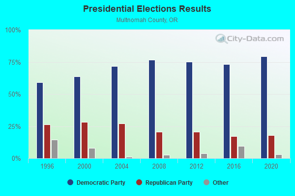
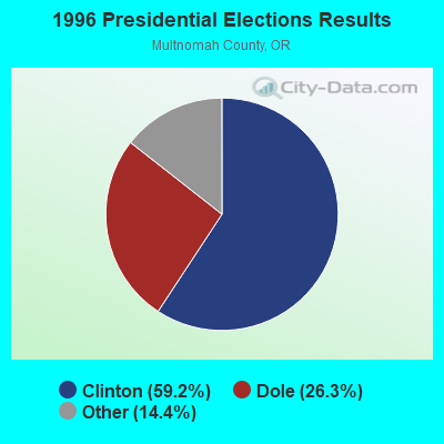
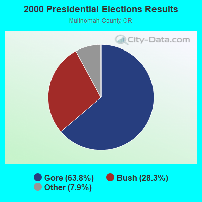
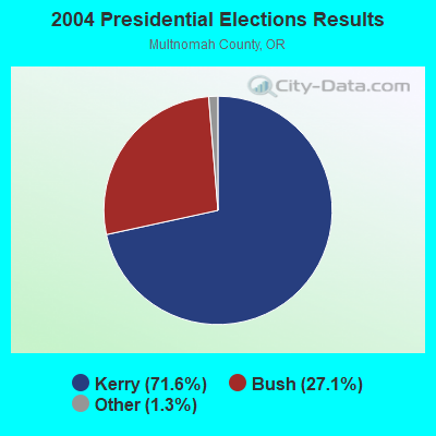
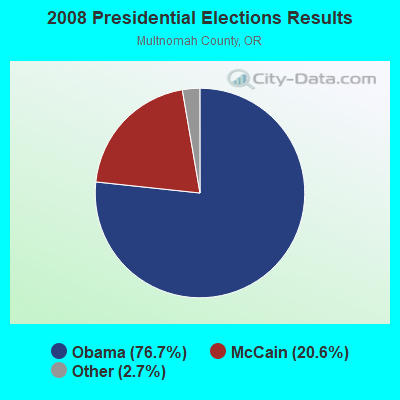
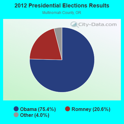
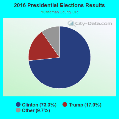
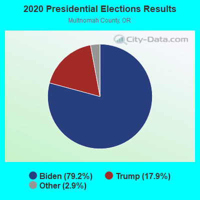
Graphs represent county-level data. Detailed 2008 Election Results
Religion statistics for Skyline, OR (based on Multnomah County data)
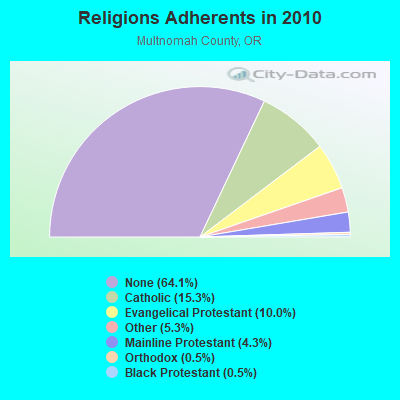
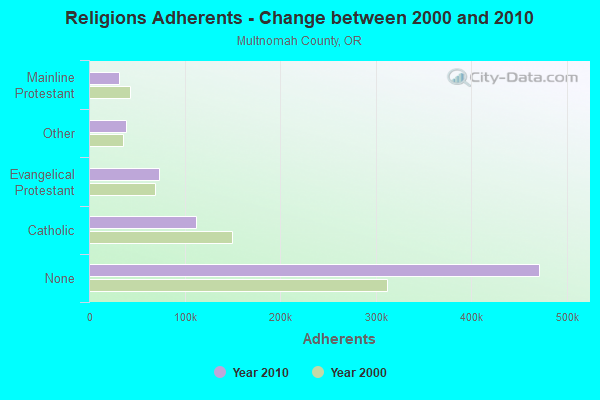
| Religion | Adherents | Congregations |
|---|---|---|
| Catholic | 112,380 | 43 |
| Evangelical Protestant | 73,465 | 313 |
| Other | 39,040 | 110 |
| Mainline Protestant | 31,544 | 127 |
| Orthodox | 3,915 | 11 |
| Black Protestant | 3,590 | 22 |
| None | 471,400 | - |
Food Environment Statistics:
| Multnomah County: | 1.74 / 10,000 pop. |
| Oregon: | 2.03 / 10,000 pop. |
| Multnomah County: | 0.23 / 10,000 pop. |
| State: | 0.33 / 10,000 pop. |
| Multnomah County: | 2.55 / 10,000 pop. |
| State: | 2.01 / 10,000 pop. |
| Here: | 1.27 / 10,000 pop. |
| Oregon: | 1.69 / 10,000 pop. |
| Multnomah County: | 14.29 / 10,000 pop. |
| State: | 9.93 / 10,000 pop. |
| This county: | 7.0% |
| Oregon: | 7.4% |
| This county: | 23.3% |
| Oregon: | 25.6% |
| This county: | 12.9% |
| Oregon: | 14.2% |
8.58% of this county's 2021 resident taxpayers lived in other counties in 2020 ($67,878 average adjusted gross income)
| Here: | 8.58% |
| Oregon average: | 8.20% |
0.01% of residents moved from foreign countries ($71 average AGI)
Multnomah County: 0.01% Oregon average: 0.01%
Top counties from which taxpayers relocated into this county between 2020 and 2021:
| from Washington County, OR | |
| from Clackamas County, OR | |
| from Clark County, WA |
10.03% of this county's 2020 resident taxpayers moved to other counties in 2021 ($87,659 average adjusted gross income)
| Here: | 10.03% |
| Oregon average: | 8.24% |
0.01% of residents moved to foreign countries ($55 average AGI)
Multnomah County: 0.01% Oregon average: 0.00%
Top counties to which taxpayers relocated from this county between 2020 and 2021:
| to Clackamas County, OR | |
| to Washington County, OR | |
| to Clark County, WA |
Strongest AM radio stations in Skyline:
- KPAM (860 AM; 50 kW; TROUTDALE, OR; Owner: PAMPLIN BROADCASTING-OREGON, INC.)
- KPOJ (620 AM; 50 kW; PORTLAND, OR; Owner: CITICASTERS LICENSES, L.P.)
- KOTK (1080 AM; 50 kW; PORTLAND, OR; Owner: FISHER BROADCASTING - PORTLAND RADIO, L.L.C.)
- KKAD (1550 AM; 50 kW; VANCOUVER, WA; Owner: PAMPLIN BROADCASTING-WASHINGTON, INC)
- KXL (750 AM; 50 kW; PORTLAND, OR; Owner: ROSE CITY RADIO CORPORATION)
- KEX (1190 AM; 50 kW; PORTLAND, OR; Owner: CITICASTERS LICENSES, L.P.)
- KKSN (1520 AM; 50 kW; OREGON CITY, OR; Owner: ENTERCOM PORTLAND LICENSE, LLC)
- KUPL (970 AM; 5 kW; PORTLAND, OR; Owner: INFINITY RADIO OPERATIONS INC.)
- KFXX (910 AM; 10 kW; VANCOUVER, WA; Owner: ENTERCOM PORTLAND LICENSE, LLC (DE))
- KKGT (1150 AM; 5 kW; PORTLAND, OR; Owner: WESTERN BROADCASTING COMPANY)
- KUIK (1360 AM; 5 kW; HILLSBORO, OR; Owner: DOLPHIN COMMUNICATIONS, INC.)
- KBMS (1480 AM; 2 kW; VANCOUVER, WA; Owner: CHRISTOPHER H. BENNETT B/CING OF WA)
- KKSL (1290 AM; 10 kW; LAKE OSWEGO, OR; Owner: ABC, INC.)
Strongest FM radio stations in Skyline:
- KRVO (105.9 FM; VANCOUVER, WA; Owner: CITICASTERS LICENSES, L.P.)
- KINK (101.9 FM; PORTLAND, OR; Owner: INFINITY RADIO OPERATIONS INC.)
- KKCW (103.3 FM; BEAVERTON, OR; Owner: CITICASTERS LICENSES, L.P.)
- KPDQ-FM (93.7 FM; PORTLAND, OR; Owner: SALEM MEDIA OF OREGON, INC.)
- KKRZ (100.3 FM; PORTLAND, OR; Owner: CITICASTERS LICENSES, L.P.)
- KOPB-FM (91.5 FM; PORTLAND, OR; Owner: OREGON PUBLIC BROADCASTING)
- KMHD (89.1 FM; GRESHAM, OR; Owner: MT. HOOD COMMUNITY COLLEGE DISTRICT)
- KVMX (107.5 FM; BANKS, OR; Owner: INFINITY RADIO OPERATIONS INC.)
- KLTH (106.7 FM; LAKE OSWEGO, OR; Owner: INIFINITY RADIO OF PORTLAND INC.)
- KUPL-FM (98.7 FM; PORTLAND, OR; Owner: INFINITY RADIO OF PORTLAND INC.)
- KUFO-FM (101.1 FM; PORTLAND, OR; Owner: INFINITY RADIO OPERATIONS INC.)
- KBVM (88.3 FM; PORTLAND, OR; Owner: CATHOLIC BROADCASTING NORTHWEST, INC)
- KBPS-FM (89.9 FM; PORTLAND, OR; Owner: SCHOOL DISTRICT #1, MULTNOMAH COUNTY, OR)
- KNRK (94.7 FM; CAMAS, WA; Owner: ENTERCOM PORTLAND LICENSE, LLC (DE))
- KFIS (104.1 FM; SCAPPOOSE, OR; Owner: CARON BROADCASTING, INC.)
- KBOO (90.7 FM; PORTLAND, OR; Owner: THE KBOO FOUNDATION)
- KWJJ-FM (99.5 FM; PORTLAND, OR; Owner: FISHER BROADCASTING - PORTLAND RADIO, L.L.C.)
- KGON (92.3 FM; PORTLAND, OR; Owner: ENTERCOM PORTLAND LICENSE, LLC (DE))
- KKSN-FM (97.1 FM; PORTLAND, OR; Owner: ENTERCOM PORTLAND LICENSE, LLC (DE))
- KXJM (95.5 FM; PORTLAND, OR; Owner: ROSE CITY RADIO CORPORATION)
TV broadcast stations around Skyline:
- KATU (Channel 2; PORTLAND, OR; Owner: FISHER BROADCASTING - PORTLAND TV, L.L.C.)
- KPDX (Channel 49; VANCOUVER, WA; Owner: MEREDITH CORPORATION)
- KPTV (Channel 12; PORTLAND, OR; Owner: MEREDITH CORPORATION)
- K57IF (Channel 57; SALEM, OR; Owner: LaGRANDE BROADCASTING, INC.)
- KGW (Channel 8; PORTLAND, OR; Owner: KING BROADCASTING COMPANY)
- KNMT (Channel 24; PORTLAND, OR; Owner: NATIONAL MINORITY T.V., INC.)
- KOIN (Channel 6; PORTLAND, OR; Owner: EMMIS TELEVISION LICENSE CORPORATION)
- KOPB-TV (Channel 10; PORTLAND, OR; Owner: OREGON PUBLIC BROADCASTING)
- KPXG-LP (Channel 54; PORTLAND, OR; Owner: PAXSON COMMUNICATIONS LICENSE COMPANY, LLC)
- K14HN (Channel 14; VANCOUVER/CAMAS, WA; Owner: MEREDITH CORPORATION)
- KWBP-LP (Channel 4; PORTLAND, OR; Owner: TRIBUNE BROADCASTING HOLDINGS, INC.)
- K18EL (Channel 18; NEWBERG/TIGARD, OR; Owner: MEREDITH CORPORATION)
- KORK-CA (Channel 35; PORTLAND, OR; Owner: WATCHTV, INC.)

- 44.2%Electricity
- 16.1%Utility gas
- 16.1%Wood
- 14.6%Fuel oil, kerosene, etc.
- 8.5%Bottled, tank, or LP gas
- 0.4%Other fuel

- 43.1%Electricity
- 23.6%Fuel oil, kerosene, etc.
- 16.9%Wood
- 14.9%Utility gas
- 1.5%Other fuel
Skyline compared to Oregon state average:
- Median household income above state average.
- Median house value above state average.
- Unemployed percentage significantly below state average.
- Black race population percentage significantly below state average.
- Hispanic race population percentage below state average.
- Median age above state average.
- Foreign-born population percentage significantly below state average.
- Renting percentage below state average.
- Length of stay since moving in significantly above state average.
- Number of rooms per house significantly below state average.
- House age significantly below state average.
Skyline on our top lists:
- #47 on the list of "Top 101 cities with the largest percentage of people in agriculture workers' dormitories on farms (population 1,000+)"
- #13 on the list of "Top 101 counties with the lowest Ozone (1-hour) air pollution readings in 2012 (ppm)"
- #15 on the list of "Top 101 counties with highest percentage of residents voting for 3rd party candidates in the 2012 Presidential Election (pop. 50,000+)"
- #19 on the list of "Top 101 counties with the highest percentage of residents that exercised in the past month"
- #22 on the list of "Top 101 counties with the largest decrease in the number of deaths per 1000 residents 2000-2006 to 2007-2013 (pop. 50,000+)"
- #25 on the list of "Top 101 counties with highest percentage of residents voting for Obama (Democrat) in the 2012 Presidential Election (pop. 50,000+)"