South Garfield, Oklahoma
Submit your own pictures of this place and show them to the world
- OSM Map
- General Map
- Google Map
- MSN Map

| Males: 1,839 | |
| Females: 1,917 |
| Median resident age: | 38.5 years |
| Oklahoma median age: | 35.5 years |
Zip code: 73773
| South Garfield: | $65,450 |
| OK: | $59,673 |
Estimated per capita income in 2022: $29,944 (it was $16,386 in 2000)
South Garfield CCD income, earnings, and wages data
Estimated median house or condo value in 2022: $139,936 (it was $51,800 in 2000)
| South Garfield: | $139,936 |
| OK: | $191,700 |
South Garfield, OK residents, houses, and apartments details
Detailed information about poverty and poor residents in South Garfield, OK
Compare current foreclosures near South Garfield, OK:
| Photo | Address | Area | Beds / Baths | Price | Details |
|---|---|---|---|---|---|

|
#1
W Cherokee Ave
Enid, OK 73703
|
2,304 sq. feet
|
2 baths 5 beds |
$74,700
|
show details |

|
#2
Aspen Dr
Enid, OK 73703
|
1,486 sq. feet
|
2 baths 3 beds |
show details | |

|
#3
Tanglewood St
Enid, OK 73703
|
1,467 sq. feet
|
2 baths 3 beds |
show details | |

|
#4
Hunters Hill Dr
Enid, OK 73703
|
1,957 sq. feet
|
2 baths 3 beds |
show details | |

|
#5
Indian Dr
Enid, OK 73703
|
1,527 sq. feet
|
2 baths 3 beds |
show details | |

|
#6
Oakwood Dr
Hennessey, OK 73742
|
- sq. feet
|
3 baths 4 beds |
show details | |

|
#7
Pawhuska Ave
Enid, OK 73703
|
1,315 sq. feet
|
2 baths 3 beds |
show details | |

|
#8
N 10th St
Enid, OK 73701
|
1,262 sq. feet
|
1 baths 2 beds |
show details | |

|
#9
Franklin Dr
Enid, OK 73703
|
2,152 sq. feet
|
2 baths 3 beds |
show details | |

|
#10
Cellar Door Ln
Enid, OK 73703
|
1,165 sq. feet
|
3 baths 3 beds |
show details |
| Photo | Address | Area | Beds / Baths | Price | Details |
|---|---|---|---|---|---|

|
#11
Oakcrest Ave
Enid, OK 73703
|
2,051 sq. feet
|
2 baths 3 beds |
show details | |

|
#12
S 20th St
Enid, OK 73701
|
1,664 sq. feet
|
1 baths 3 beds |
show details | |

|
#13
N Cheyenne St
Hennessey, OK 73742
|
1,787 sq. feet
|
2 baths 3 beds |
show details | |

|
#14
Birchwood St
Enid, OK 73703
|
1,270 sq. feet
|
2 baths 3 beds |
show details | |

|
#15
Alamo Rd
Enid, OK 73703
|
1,412 sq. feet
|
2 baths 3 beds |
show details | |

|
#16
Alamo Rd
Enid, OK 73703
|
1,467 sq. feet
|
2 baths 3 beds |
show details | |

|
#17
E Cedar Ave
Enid, OK 73701
|
1,182 sq. feet
|
1 baths 3 beds |
show details | |

|
#18
Rampart St
Enid, OK 73703
|
1,514 sq. feet
|
2 baths 3 beds |
show details | |

|
#19
Wildoak Cir
Enid, OK 73701
|
1,160 sq. feet
|
2 baths 3 beds |
show details | |

|
#20
S Rimrock Rd
Enid, OK 73703
|
1,356 sq. feet
|
2 baths 3 beds |
show details |
| Photo | Address | Area | Beds / Baths | Price | Details |
|---|---|---|---|---|---|

|
#21
N Watson St
Enid, OK 73703
|
1,990 sq. feet
|
2 baths 3 beds |
show details | |

|
#22
N 12th St
Enid, OK 73701
|
1,726 sq. feet
|
2 baths 5 beds |
show details | |

|
#23
Franklin Dr
Enid, OK 73703
|
1,705 sq. feet
|
2 baths 3 beds |
show details | |

|
#24
Mt Vernon Rd
Enid, OK 73703
|
1,376 sq. feet
|
2 baths 3 beds |
show details | |

|
#25
E 1st St
Hennessey, OK 73742
|
1,774 sq. feet
|
2 baths 2 beds |
show details | |

|
#26
E Rupe Ave
Covington, OK 73730
|
3 sq. feet
|
2 baths 3 beds |
show details | |

|
#27
S Coolidge St
Enid, OK 73703
|
2,002 sq. feet
|
1 baths 3 beds |
show details | |

|
#28
W Poplar Ave
Enid, OK 73701
|
1,376 sq. feet
|
1 baths 4 beds |
show details | |

|
#29
N 13th St
Enid, OK 73701
|
883 sq. feet
|
1 baths 2 beds |
show details | |

|
#30
E Cherry Ave
Enid, OK 73701
|
932 sq. feet
|
1 baths 3 beds |
show details |
| Photo | Address | Area | Beds / Baths | Price | Details |
|---|---|---|---|---|---|

|
#31
Cheyenne Ave
Enid, OK 73703
|
1,471 sq. feet
|
2 baths 2 beds |
show details | |

|
#32
N Cleveland St Apt 23
Enid, OK 73703
|
- sq. feet
|
- baths - beds |
show details | |

|
#33
N Macarthur Blvd
Crescent, OK 73028
|
1,456 sq. feet
|
- baths - beds |
show details | |

|
#34
State Highway 51
Hennessey, OK 73742
|
- sq. feet
|
- baths - beds |
show details | |

|
#35
S 30th St
Enid, OK 73701
|
- sq. feet
|
- baths - beds |
show details | |

|
#36
W Willow Rd # D6
Enid, OK 73703
|
- sq. feet
|
- baths - beds |
show details | |

|
#37
Ridgeview Ave
Enid, OK 73703
|
- sq. feet
|
- baths - beds |
show details | |

|
#38
Northgate Dr
Enid, OK 73703
|
- sq. feet
|
- baths - beds |
show details | |

|
#39
S La Mesa Dr Apt I5
Enid, OK 73703
|
- sq. feet
|
- baths - beds |
show details | |

|
#40
W Palm St
Enid, OK 73701
|
- sq. feet
|
- baths - beds |
show details |
| Photo | Address | Area | Beds / Baths | Price | Details |
|---|---|---|---|---|---|

|
#41
N Monroe St
Enid, OK 73701
|
- sq. feet
|
- baths - beds |
show details | |

|
#42
S Oakwood Rd Apt 1210
Enid, OK 73703
|
- sq. feet
|
- baths - beds |
show details | |

|
#43
E Cottonwood Ave
Enid, OK 73701
|
- sq. feet
|
- baths - beds |
show details | |

|
#44
W Oklahoma Ave
Enid, OK 73703
|
- sq. feet
|
- baths - beds |
show details | |

|
#45
Kaw St
Enid, OK 73703
|
- sq. feet
|
- baths - beds |
show details | |

|
#46
N 2970 Rd
Crescent, OK 73028
|
- sq. feet
|
- baths - beds |
show details | |

|
Check over 1 million property listings on Foreclosure.com!
|
browse all offers | |||

- 3,50893.0%White alone
- 972.6%American Indian alone
- 701.9%Two or more races
- 681.8%Hispanic
- 190.5%Black alone
- 80.2%Asian alone
- 20.05%Other race alone
- 10.03%Native Hawaiian and Other
Pacific Islander alone

Races in South Garfield detailed stats: ancestries, foreign born residents, place of birth
 Recent articles from our blog. Our writers, many of them Ph.D. graduates or candidates, create easy-to-read articles on a wide variety of topics.
Current Local Time: CST time zone
Land area: 420.6 square miles.
Population density: 8.9 people per square mile (very low).

| South Garfield CCD: | 0.6% ($336) |
| Oklahoma: | 0.8% ($523) |
Nearest city with pop. 50,000+: Edmond, OK  (45.6 miles , pop. 68,315).
Nearest city with pop. 200,000+: Oklahoma City, OK (56.0 miles , pop. 506,132).
Nearest city with pop. 1,000,000+: Dallas, TX (246.4 miles , pop. 1,188,580).
Nearest cities:
), ), )Latitude: 36.27 N, Longitude: 97.76 W
Area code commonly used in this area: 580


| Here: | 3.4% |
| Oklahoma: | 3.2% |

- Agriculture, forestry, fishing & hunting (10.8%)
- Health care (8.7%)
- Educational services (7.9%)
- Construction (6.6%)
- Mining, quarrying, oil & gas extraction (4.9%)
- Accommodation & food services (4.3%)
- Public administration (4.1%)

- Agriculture, forestry, fishing & hunting (15.5%)
- Construction (11.2%)
- Mining, quarrying, oil & gas extraction (7.1%)
- Machinery (5.1%)
- Truck transportation (5.0%)
- Transportation equipment (4.7%)
- Public administration (4.4%)

- Health care (17.3%)
- Educational services (14.0%)
- Accommodation & food services (6.7%)
- Social assistance (5.2%)
- Finance & insurance (5.0%)
- Food & beverage stores (5.0%)
- Agriculture, forestry, fishing & hunting (4.5%)

- Farmers and farm managers (7.3%)
- Driver/sales workers and truck drivers (4.6%)
- Secretaries and administrative assistants (3.7%)
- Preschool, kindergarten, elementary, and middle school teachers (3.7%)
- Metal workers and plastic workers (3.6%)
- Vehicle and mobile equipment mechanics, installers, and repairers (3.6%)
- Building and grounds cleaning and maintenance occupations (3.4%)

- Farmers and farm managers (10.8%)
- Driver/sales workers and truck drivers (7.3%)
- Metal workers and plastic workers (6.3%)
- Vehicle and mobile equipment mechanics, installers, and repairers (6.0%)
- Agricultural workers, including supervisors (4.3%)
- Electrical equipment mechanics and other installation, maintenance, and repair workers, including supervisors (4.2%)
- Other sales and related occupations, including supervisors (3.6%)

- Secretaries and administrative assistants (8.7%)
- Cashiers (7.0%)
- Preschool, kindergarten, elementary, and middle school teachers (6.4%)
- Bookkeeping, accounting, and auditing clerks (5.2%)
- Retail sales workers, except cashiers (4.4%)
- Building and grounds cleaning and maintenance occupations (4.0%)
- Health technologists and technicians (3.7%)
Average climate in South Garfield, Oklahoma
Based on data reported by over 4,000 weather stations


(lower is better)

Air Quality Index (AQI) level in 2000 was 48.9. This is significantly better than average.
| City: | 48.9 |
| U.S.: | 72.6 |

Nitrogen Dioxide (NO2) [ppb] level in 2000 was 6.96. This is worse than average. Closest monitor was 12.2 miles away from the city center.
| City: | 6.96 |
| U.S.: | 5.11 |
Tornado activity:
South Garfield-area historical tornado activity is slightly above Oklahoma state average. It is 183% greater than the overall U.S. average.
On 5/3/1999, a category F4 (max. wind speeds 207-260 mph) tornado 13.9 miles away from the South Garfield place center killed one person and injured 11 people and caused $2 million in damages.
On 5/2/1979, a category F4 tornado 14.3 miles away from the place center killed one person and injured 25 people and caused between $500,000 and $5,000,000 in damages.
Earthquake activity:
South Garfield-area historical earthquake activity is significantly above Oklahoma state average. It is 935% greater than the overall U.S. average.On 9/3/2016 at 12:02:44, a magnitude 5.8 (5.8 MW, Depth: 3.5 mi, Class: Moderate, Intensity: VI - VII) earthquake occurred 47.7 miles away from South Garfield center
On 11/6/2011 at 03:53:10, a magnitude 5.7 (5.7 MW, Depth: 3.2 mi) earthquake occurred 75.7 miles away from South Garfield center
On 2/13/2016 at 17:07:06, a magnitude 5.1 (5.1 MW, Depth: 5.2 mi) earthquake occurred 54.8 miles away from South Garfield center
On 11/7/2016 at 01:44:24, a magnitude 5.0 (5.0 MW, Depth: 2.8 mi) earthquake occurred 57.0 miles away from the city center
On 11/12/2014 at 21:40:00, a magnitude 4.9 (4.9 MW, Depth: 2.5 mi, Class: Light, Intensity: IV - V) earthquake occurred 69.7 miles away from South Garfield center
On 4/9/2018 at 10:22:20, a magnitude 4.6 (4.6 MW, Depth: 3.1 mi) earthquake occurred 11.2 miles away from the city center
Magnitude types: moment magnitude (MW)
Natural disasters:
The number of natural disasters in Garfield County (20) is greater than the US average (15).Major Disasters (Presidential) Declared: 13
Emergencies Declared: 5
Causes of natural disasters: Floods: 9, Storms: 9, Winter Storms: 8, Tornadoes: 5, Hurricane: 1, Ice Storm: 1, Snowstorm: 1, Wind: 1, Other: 1 (Note: some incidents may be assigned to more than one category).
Hospitals and medical centers near South Garfield:
- ENID SENIOR CARE (Nursing Home, about 10 miles away; ENID, OK)
- UNIVERSITY NURSING CENTER (Nursing Home, about 10 miles away; ENID, OK)
- GREENBRIER NURSING HOME (Nursing Home, about 10 miles away; ENID, OK)
- GREENBRIER NURSING HOME NUMBER TWO INC (Nursing Home, about 10 miles away; ENID, OK)
- MEADOWLAKE BEHAVIORAL HEALTH SYSTEM (Hospital, about 11 miles away; ENID, OK)
- ST MARY'S MERCY HOME HEALTH (Home Health Center, about 11 miles away; ENID, OK)
- ST MARY'S REGIONAL MEDICAL CENTER Acute Care Hospitals (about 11 miles away; ENID, OK)
Colleges/universities with over 2000 students nearest to South Garfield:
- Langston University (about 37 miles; Langston, OK; Full-time enrollment: 2,075)
- Northern Oklahoma College (about 39 miles; Tonkawa, OK; FT enrollment: 3,414)
- Oklahoma State University-Main Campus (about 41 miles; Stillwater, OK; FT enrollment: 21,700)
- University of Central Oklahoma (about 46 miles; Edmond, OK; FT enrollment: 13,790)
- Oklahoma Christian University (about 49 miles; Edmond, OK; FT enrollment: 2,173)
- Southern Nazarene University (about 53 miles; Bethany, OK; FT enrollment: 2,064)
- Oklahoma City University (about 56 miles; Oklahoma City, OK; FT enrollment: 2,547)
Points of interest:
Notable locations in South Garfield: Lincoln Center School (A), Highland School (B), Drummond Fire Department (C), Douglas Volunteer Fire Department (D), Covington Volunteer Fire and Rescue (E), Waukomis Fire Department (F), Pioneer Skeleton Creek Fire District (G). Display/hide their locations on the map
Churches in South Garfield include: Bethlehem Church (A), Waukomis United Methodist Church (B), Waukomis Baptist Church (C), Eden Church (D), New Bethany Church (E), Pleasant Valley Church (F), Potter Church (G), Wesleyan Chapel (H), Our Church (I). Display/hide their locations on the map
Cemeteries: Waukomis Cemetery (1), German Cemetery (2), Union Cemetery (3), Hackberry Cemetery (4), Bethel Cemetery (5), Bison Cemetery (6), Pioneer Cemetery (7). Display/hide their locations on the map
Lakes and reservoirs: Steinerts Lake (A), Upper Black Bear Creek Site 48 Reservoir (B), Upper Black Bear Creek Site 49 Reservoir (C), Upper Black Bear Creek Site 43 Reservoir (D), Upper Black Bear Creek Site 39 Reservoir (E), Upper Black Bear Creek Site 40 Reservoir (F), Upper Black Bear Creek Site 42 Reservoir (G), Upper Black Bear Creek Site 37 Reservoir (H). Display/hide their locations on the map
Creeks: Crows Nest Creek (A), Crow Creek (B), Hell and Gone Creek (C), Bitter Creek (D), Sand Creek (E), Rock Creek (F), Wolf Creek (G), Hackberry Creek (H). Display/hide their locations on the map
Park in South Garfield: Pioneer Community Park (1). Display/hide its location on the map
| This place: | 2.4 people |
| Oklahoma: | 2.5 people |
| This place: | 72.5% |
| Whole state: | 66.8% |
| This place: | 4.2% |
| Whole state: | 5.9% |
Likely homosexual households (counted as self-reported same-sex unmarried-partner households)
- Lesbian couples: 0.3% of all households
- Gay men: 0.3% of all households
| This place: | 11.7% |
| Whole state: | 14.7% |
| This place: | 4.3% |
| Whole state: | 6.1% |
For population 15 years and over in South Garfield:

- Never married: 18.5%
- Now married: 66.2%
- Separated: 1.4%
- Widowed: 7.5%
- Divorced: 7.8%
For population 25 years and over in South Garfield:
- High school or higher: 83.3%
- Bachelor's degree or higher: 15.4%
- Graduate or professional degree: 3.8%
- Unemployed: 3.0%
- Mean travel time to work (commute): 21.5 minutes


| Here: | 9.4 |
| Oklahoma average: | 11.7 |
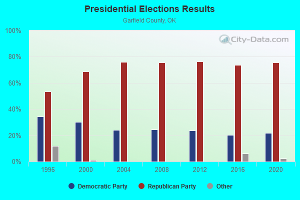
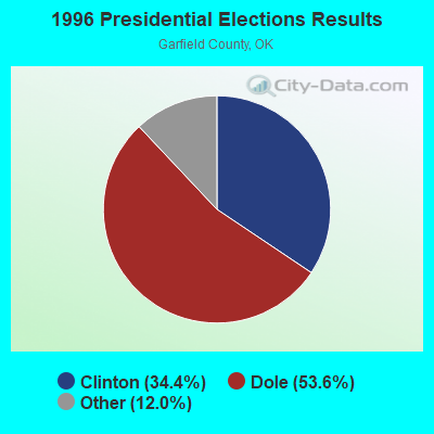


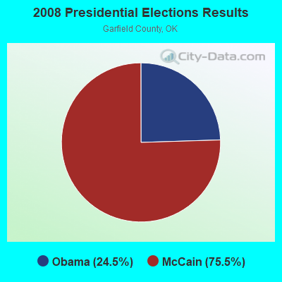
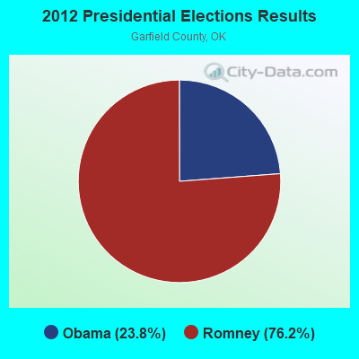
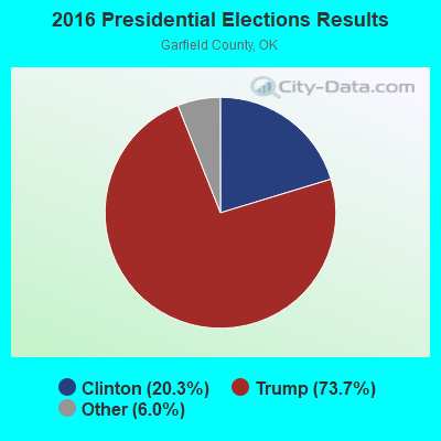
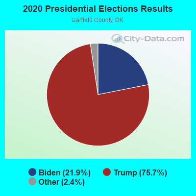
Graphs represent county-level data. Detailed 2008 Election Results
Religion statistics for South Garfield, OK (based on Garfield County data)
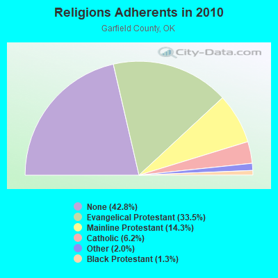
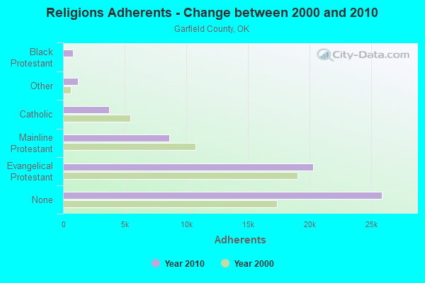
| Religion | Adherents | Congregations |
|---|---|---|
| Evangelical Protestant | 20,284 | 85 |
| Mainline Protestant | 8,651 | 27 |
| Catholic | 3,743 | 3 |
| Other | 1,221 | 4 |
| Black Protestant | 777 | 5 |
| None | 25,904 | - |
Food Environment Statistics:
| Garfield County: | 1.57 / 10,000 pop. |
| Oklahoma: | 1.97 / 10,000 pop. |
| Here: | 0.17 / 10,000 pop. |
| Oklahoma: | 0.20 / 10,000 pop. |
| Garfield County: | 2.09 / 10,000 pop. |
| State: | 0.76 / 10,000 pop. |
| This county: | 4.52 / 10,000 pop. |
| State: | 4.35 / 10,000 pop. |
| Here: | 6.09 / 10,000 pop. |
| Oklahoma: | 6.89 / 10,000 pop. |
| Here: | 10.2% |
| Oklahoma: | 10.3% |
| Garfield County: | 31.7% |
| State: | 29.2% |
7.04% of this county's 2021 resident taxpayers lived in other counties in 2020 ($49,656 average adjusted gross income)
| Here: | 7.04% |
| Oklahoma average: | 8.28% |
0.14% of residents moved from foreign countries ($1,521 average AGI)
Garfield County: 0.14% Oklahoma average: 0.04%
Top counties from which taxpayers relocated into this county between 2020 and 2021:
| from Oklahoma County, OK | |
| from El Paso County, CO | |
| from Major County, OK |
7.66% of this county's 2020 resident taxpayers moved to other counties in 2021 ($51,135 average adjusted gross income)
| Here: | 7.66% |
| Oklahoma average: | 7.66% |
0.13% of residents moved to foreign countries ($1,027 average AGI)
Garfield County: 0.13% Oklahoma average: 0.03%
Top counties to which taxpayers relocated from this county between 2020 and 2021:
| to Oklahoma County, OK | |
| to Tulsa County, OK | |
| to Kay County, OK |
Strongest AM radio stations in South Garfield:
- KCRC (1390 AM; 10 kW; ENID, OK; Owner: CHISHOLM TRAIL BROADCASTING CO.)
- KRMG (740 AM; 50 kW; TULSA, OK; Owner: CXR HOLDINGS, INC.)
- KOMA (1520 AM; 50 kW; OKLAHOMA CITY, OK; Owner: RENDA BROADCASTING CORP. OF NEVADA)
- KGWA (960 AM; 1 kW; ENID, OK; Owner: WILLIAMS CAPITOL CORPORATION)
- KFAQ (1170 AM; 50 kW; TULSA, OK; Owner: JOURNAL BROADCAST CORPORATION)
- WKY (930 AM; 5 kW; OKLAHOMA CITY, OK; Owner: CITADEL BROADCASTING COMPANY)
- KTBZ (1430 AM; 25 kW; TULSA, OK; Owner: CLEAR CHANNEL BROADCASTING LICENSES, INC.)
- WWLS (640 AM; 5 kW; MOORE, OK; Owner: CITADEL BROADCASTING COMPANY)
- KMUS (1380 AM; 20 kW; MUSKOGEE, OK; Owner: ABC, INC.)
- KTOK (1000 AM; 5 kW; OKLAHOMA CITY, OK; Owner: CLEAR CHANNEL BROADCASTING LICENSES, INC.)
- KGYN (1210 AM; 50 kW; GUYMON, OK; Owner: TELNS BROADCASTING COMPANY, INC.)
- WBAP (820 AM; 50 kW; FORT WORTH, TX; Owner: WBAP-KSCS OPERATING, LTD.)
- KQCV (800 AM; 2 kW; OKLAHOMA CITY, OK; Owner: BOTT BROADCASTING COMPANY)
Strongest FM radio stations in South Garfield:
- KQBL (96.9 FM; ENID, OK; Owner: CHAMPLIN BROADCASTING, INC.)
- KOFM (103.1 FM; ENID, OK; Owner: WILLIAMS CAPITOL CORPORATION)
- KBVV (91.1 FM; ENID, OK; Owner: ENID EDUCATIONAL B/CTING FOUNDATION)
- KXLS (95.7 FM; LAHOMA, OK; Owner: CHISHOLM TRAIL BROADCASTING CO.)
- KOSU-FM (91.7 FM; STILLWATER, OK; Owner: OKLAHOMA STATE UNIVERSITY)
- KSPI-FM (93.7 FM; STILLWATER, OK; Owner: STILLWATER BROADCASTING, L.L.C.)
- KNID (99.7 FM; ALVA, OK; Owner: CHRISHOLM TRAIL BROADCASTING COMPANY)
- KHBZ-FM (94.7 FM; OKLAHOMA CITY, OK; Owner: CLEAR CHANNEL BROADCASTING LICENSES, INC.)
- KTST (101.9 FM; OKLAHOMA CITY, OK; Owner: CLEAR CHANNEL BROADCASTING LICENSES, INC.)
- KMGL (104.1 FM; OKLAHOMA CITY, OK; Owner: RENDA BROADCASTING CORP. OF NEVADA)
- KJYO (102.7 FM; OKLAHOMA CITY, OK; Owner: CLEAR CHANNEL BROADCASTING LICENSES, INC.)
- KXXY-FM (96.1 FM; OKLAHOMA CITY, OK; Owner: CLEAR CHANNEL BROADCASTING LICENSES, INC.)
- K296EH (107.1 FM; PERRY, OK; Owner: THE LOVE STATION, INC.)
- K202BY (88.3 FM; ENID, OK; Owner: FAMILY STATIONS, INC.)
- KOSB (105.1 FM; PERRY, OK; Owner: TEAM RADIO, L.L.C.)
- K212EL (90.3 FM; ENID, OK; Owner: BIBLE BROADCASTING NETWORK, INC.)
- K208BV (89.5 FM; ENID, ETC., OK; Owner: CREATIVE EDUCATIONAL MEDIA CORP. INC)
TV broadcast stations around South Garfield:
- KWTV (Channel 9; OKLAHOMA CITY, OK; Owner: GRIFFIN ENTITIES, L.L.C.)
- KXOK-LP (Channel 32; ENID, OK; Owner: MEDIA MANICS INCORPORATED)
- KOCO-TV (Channel 5; OKLAHOMA CITY, OK; Owner: OHIO/OKLAHOMA HEARST- ARGYLE TELEVISION)
- KOPX (Channel 62; OKLAHOMA CITY, OK; Owner: PAXSON OKLAHOMA CITY LICENSE, INC.)
- KFOR-TV (Channel 4; OKLAHOMA CITY, OK; Owner: NEW YORK TIMES MANAGEMENT SERVICES)
- KSBI (Channel 52; OKLAHOMA CITY, OK; Owner: LOCKE SUPPLY CO.)
- K45EJ (Channel 45; ENID, OK; Owner: LOCKE SUPPLY COMPANY)
- KOKH-TV (Channel 25; OKLAHOMA CITY, OK; Owner: KOKH LICENSEE, LLC)
- KETA-TV (Channel 13; OKLAHOMA CITY, OK; Owner: OKLAHOMA EDUCATIONAL TELEVISION AUTHORITY)
- KOCB (Channel 34; OKLAHOMA CITY, OK; Owner: KOCB LICENSEE, LLC)
- K21DF (Channel 21; STILLWATER, OK; Owner: LOCKE SUPPLY CO.)
- KWEM-LP (Channel 31; STILLWATER, OK; Owner: WESTWOOD MEDIA GROUP, INC.)
- KOKQ-LP (Channel 50; GLENCOE, OK; Owner: WELLSPRINGS TELEVISION NETWORK, INC.)

- 42.2%Utility gas
- 29.3%Electricity
- 24.8%Bottled, tank, or LP gas
- 2.3%Wood
- 0.9%Fuel oil, kerosene, etc.
- 0.5%Other fuel

- 46.5%Utility gas
- 26.6%Bottled, tank, or LP gas
- 20.6%Electricity
- 2.7%Fuel oil, kerosene, etc.
- 2.0%Other fuel
- 1.0%Coal or coke
- 0.7%Wood
South Garfield compared to Oklahoma state average:
- Unemployed percentage significantly below state average.
- Black race population percentage significantly below state average.
- Hispanic race population percentage significantly below state average.
- Foreign-born population percentage significantly below state average.
- Length of stay since moving in significantly above state average.
- Number of rooms per house significantly below state average.
- House age significantly below state average.
- Number of college students below state average.