Southeast Chaves, New Mexico
Submit your own pictures of this place and show them to the world
- OSM Map
- General Map
- Google Map
- MSN Map

| Males: 896 | |
| Females: 816 |
| Median resident age: | 34.5 years |
| New Mexico median age: | 34.6 years |
Zip code: 88230
| Southeast Chaves: | $55,519 |
| NM: | $59,726 |
Estimated per capita income in 2022: $24,686 (it was $13,415 in 2000)
Southeast Chaves CCD income, earnings, and wages data
Estimated median house or condo value in 2022: $154,142 (it was $58,300 in 2000)
| Southeast Chaves: | $154,142 |
| NM: | $243,100 |
Southeast Chaves, NM residents, houses, and apartments details
Detailed information about poverty and poor residents in Southeast Chaves, NM


- 99459.1%White alone
- 63838.0%Hispanic
- 311.8%Two or more races
- 130.8%American Indian alone
- 20.1%Black alone
- 20.1%Asian alone
- 10.06%Other race alone

Races in Southeast Chaves detailed stats: ancestries, foreign born residents, place of birth
 Recent articles from our blog. Our writers, many of them Ph.D. graduates or candidates, create easy-to-read articles on a wide variety of topics.
Current Local Time: MST time zone
Land area: 663.9 square miles.
Population density: 2.6 people per square mile (very low).

| Southeast Chaves CCD: | 0.7% ($390) |
| New Mexico: | 0.7% ($699) |
Nearest city with pop. 50,000+: Lubbock, TX  (135.9 miles , pop. 199,564).
Nearest city with pop. 200,000+: El Paso, TX (166.2 miles , pop. 563,662).
Nearest city with pop. 1,000,000+: San Antonio, TX (429.1 miles , pop. 1,144,646).
Nearest cities:
), )Latitude: 33.30 N, Longitude: 104.21 W
Area code commonly used in this area: 505


| Here: | 3.6% |
| New Mexico: | 3.6% |

- Agriculture, forestry, fishing & hunting (22.9%)
- Educational services (13.9%)
- Professional, scientific, technical services (6.6%)
- Food (4.6%)
- Accommodation & food services (4.3%)
- Health care (4.2%)
- Transportation equipment (4.0%)

- Agriculture, forestry, fishing & hunting (31.5%)
- Professional, scientific, technical services (9.3%)
- Educational services (9.3%)
- Transportation equipment (5.3%)
- Food (4.1%)
- Construction (3.6%)
- Repair & maintenance (2.9%)

- Educational services (21.8%)
- Accommodation & food services (11.7%)
- Health care (10.9%)
- Agriculture, forestry, fishing & hunting (8.5%)
- Public administration (6.9%)
- Finance & insurance (6.0%)
- Food (5.6%)

- Agricultural workers, including supervisors (12.6%)
- Driver/sales workers and truck drivers (6.1%)
- Farmers and farm managers (5.5%)
- Retail sales workers, except cashiers (5.1%)
- Drafters, engineering, and mapping technicians (4.8%)
- Other production occupations, including supervisors (4.0%)
- Supervisors and other personal care and service workers, except child care workers (3.9%)

- Agricultural workers, including supervisors (17.4%)
- Driver/sales workers and truck drivers (8.6%)
- Farmers and farm managers (8.1%)
- Drafters, engineering, and mapping technicians (7.6%)
- Other production occupations, including supervisors (5.7%)
- Metal workers and plastic workers (5.3%)
- Retail sales workers, except cashiers (5.0%)

- Secretaries and administrative assistants (7.3%)
- Preschool, kindergarten, elementary, and middle school teachers (6.9%)
- Cooks and food preparation workers (6.9%)
- Registered nurses (6.5%)
- Supervisors and other personal care and service workers, except child care workers (6.0%)
- Financial clerks, except bookkeeping, accounting and auditing clerks (6.0%)
- Retail sales workers, except cashiers (5.2%)
Average climate in Southeast Chaves, New Mexico
Based on data reported by over 4,000 weather stations


Tornado activity:
Southeast Chaves-area historical tornado activity is significantly above New Mexico state average. It is 74% smaller than the overall U.S. average.
On 6/12/1962, a category F2 (max. wind speeds 113-157 mph) tornado 18.0 miles away from the Southeast Chaves place center caused between $500 and $5000 in damages.
On 8/11/1974, a category F2 tornado 19.4 miles away from the place center caused between $5000 and $50,000 in damages.
Earthquake activity:
Southeast Chaves-area historical earthquake activity is significantly above New Mexico state average. It is 416% greater than the overall U.S. average.On 4/14/1995 at 00:32:56, a magnitude 5.7 (5.6 MB, 5.7 MS, 5.7 MW, Depth: 11.1 mi, Class: Moderate, Intensity: VI - VII) earthquake occurred 215.1 miles away from Southeast Chaves center
On 1/2/1992 at 11:45:35, a magnitude 5.0 (4.6 MB, 5.0 LG, Depth: 3.1 mi) earthquake occurred 93.1 miles away from the city center
On 3/26/2020 at 15:16:27, a magnitude 5.0 (5.0 MW, Depth: 5.9 mi) earthquake occurred 110.3 miles away from the city center
On 6/16/1978 at 11:46:54, a magnitude 5.3 (4.4 MB, 4.6 UK, 5.3 ML) earthquake occurred 200.3 miles away from Southeast Chaves center
On 8/23/2011 at 05:46:18, a magnitude 5.3 (5.3 MW, Depth: 2.5 mi) earthquake occurred 261.4 miles away from Southeast Chaves center
On 1/29/1990 at 13:16:10, a magnitude 4.8 (4.5 MB, 4.8 LG, Depth: 7.5 mi, Class: Light, Intensity: IV - V) earthquake occurred 172.9 miles away from Southeast Chaves center
Magnitude types: regional Lg-wave magnitude (LG), body-wave magnitude (MB), local magnitude (ML), surface-wave magnitude (MS), moment magnitude (MW)
Natural disasters:
The number of natural disasters in Chaves County (6) is a lot smaller than the US average (15).Major Disasters (Presidential) Declared: 3
Emergencies Declared: 2
Causes of natural disasters: Fires: 2, Flood: 1, Hurricane: 1, Mudslide: 1, Storm: 1, Winter Storm: 1, Other: 1 (Note: some incidents may be assigned to more than one category).
Colleges/universities with over 2000 students nearest to Southeast Chaves:
- Eastern New Mexico University-Roswell Campus (about 19 miles; Roswell, NM; Full-time enrollment: 2,212)
- Eastern New Mexico University-Main Campus (about 79 miles; Portales, NM; FT enrollment: 4,263)
- South Plains College (about 109 miles; Levelland, TX; FT enrollment: 7,007)
- Texas Tech University Health Sciences Center (about 136 miles; Lubbock, TX; FT enrollment: 3,269)
- Texas Tech University (about 137 miles; Lubbock, TX; FT enrollment: 29,251)
- Odessa College (about 146 miles; Odessa, TX; FT enrollment: 3,107)
- The University of Texas of the Permian Basin (about 147 miles; Odessa, TX; FT enrollment: 2,982)
Points of interest:
Notable locations in Southeast Chaves: L-E Ranch (A), L-N Ranch (B), Lone Wolf Windmills (C), Malstrom Ranch (D), North Windmill (E), Oasis Ranch (F), Orchard Park Station (G), South Spring Ranch (H), Wade Ranch (I), Langenegger (J), Anchor D Ranch (K), Atkinson Ranch (L), Backus Windmill (M), Bar C Bar Ranch (N), Fin and Feather Club (O), Calumet Ranch (P), Culp (Q), Caudill Ranch (R), Culp Ranch (S), Ervin Ranch (T). Display/hide their locations on the map
Church in Southeast Chaves: Shady Grove Church (A). Display/hide its location on the map
Lakes and reservoirs: Inkwell Lake (A), Alkali Lake (B), Bottomless Lakes (C), Red Lake (D), Cottonwood Lake (E), Figure Eight Lake (F), Cockle Burr Lake (G), Chain Lakes (H). Display/hide their locations on the map
Streams, rivers, and creeks: South Spring River (A), East Fork Long Arroyo (B), Loco Draw (C), Rio Hondo (D). Display/hide their locations on the map
Park in Southeast Chaves: Bottomless Lakes State Park (1). Display/hide its location on the map
| This place: | 2.8 people |
| New Mexico: | 2.5 people |
| This place: | 76.8% |
| Whole state: | 65.5% |
| This place: | 4.6% |
| Whole state: | 8.2% |
Likely homosexual households (counted as self-reported same-sex unmarried-partner households)
- Lesbian couples: 0.6% of all households
- Gay men: 0.0% of all households
| This place: | 10.7% |
| Whole state: | 18.4% |
| This place: | 5.7% |
| Whole state: | 7.8% |
For population 15 years and over in Southeast Chaves:

- Never married: 19.2%
- Now married: 68.5%
- Separated: 1.3%
- Widowed: 5.0%
- Divorced: 7.3%
For population 25 years and over in Southeast Chaves:
- High school or higher: 69.4%
- Bachelor's degree or higher: 18.1%
- Graduate or professional degree: 4.9%
- Unemployed: 8.1%
- Mean travel time to work (commute): 16.6 minutes


| Here: | 16.4 |
| New Mexico average: | 14.5 |
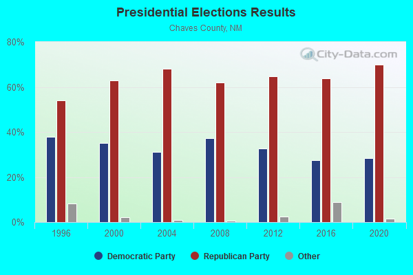
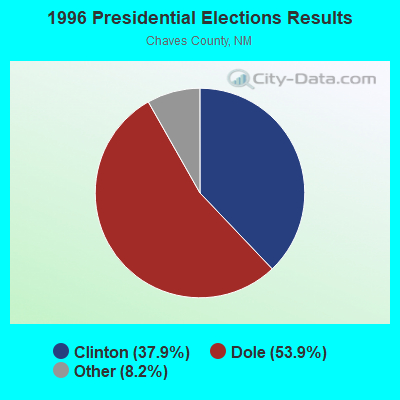
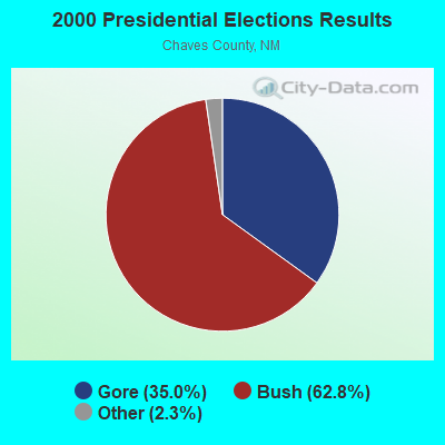

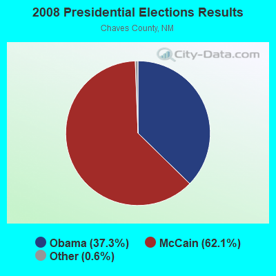

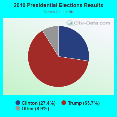
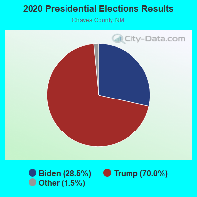
Graphs represent county-level data. Detailed 2008 Election Results
Religion statistics for Southeast Chaves, NM (based on Chaves County data)
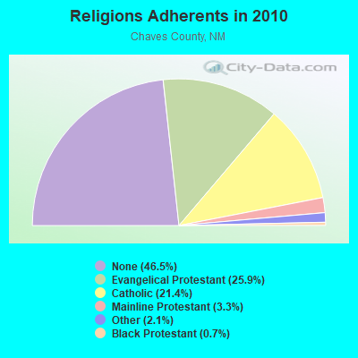
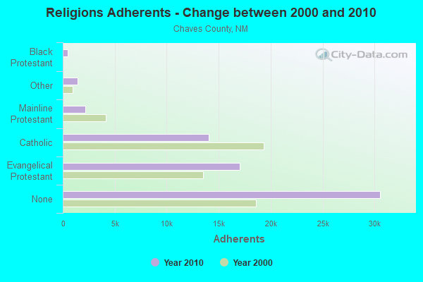
| Religion | Adherents | Congregations |
|---|---|---|
| Evangelical Protestant | 17,026 | 59 |
| Catholic | 14,031 | 6 |
| Mainline Protestant | 2,193 | 11 |
| Other | 1,399 | 10 |
| Black Protestant | 448 | 3 |
| None | 30,548 | - |
Food Environment Statistics:
| Chaves County: | 1.44 / 10,000 pop. |
| State: | 1.44 / 10,000 pop. |
| This county: | 0.32 / 10,000 pop. |
| New Mexico: | 0.21 / 10,000 pop. |
| Chaves County: | 0.32 / 10,000 pop. |
| New Mexico: | 0.32 / 10,000 pop. |
| This county: | 4.16 / 10,000 pop. |
| New Mexico: | 4.06 / 10,000 pop. |
| This county: | 7.85 / 10,000 pop. |
| New Mexico: | 7.12 / 10,000 pop. |
| Here: | 8.1% |
| State: | 6.4% |
| This county: | 25.6% |
| New Mexico: | 22.1% |
| This county: | 10.6% |
| State: | 11.5% |
Strongest AM radio stations in Southeast Chaves:
- KINF (1020 AM; 50 kW; ROSWELL, NM; Owner: JAMES CRYSTAL HOLDINGS OF NEW MEXICO, INC.)
- KBIM (910 AM; 5 kW; ROSWELL, NM; Owner: KING BROADCASTING COMPANY)
- KCRX (1430 AM; 5 kW; ROSWELL, NM; Owner: ROSENDO CASAREZ, JR.)
- KICA (980 AM; 50 kW; CLOVIS, NM; Owner: BROADCAST ENTERTAINMENT CORPORATION)
- KMUL (1380 AM; 50 kW; MULESHOE, TX; Owner: BROADCAST ENTERTAINMENT CORPORATION)
- KRDD (1320 AM; 1 kW; ROSWELL, NM; Owner: TRINNIE B. ESPINOZA)
- KPSA (1230 AM; 1 kW; ROSWELL, NM; Owner: ROSWELL RADIO, INC.)
- KKOB (770 AM; 50 kW; ALBUQUERQUE, NM; Owner: CITADEL BROADCASTING COMPANY)
- KELP (1590 AM; 50 kW; EL PASO, TX; Owner: MCCLATCHEY BROADCASTING)
- KYKK (1110 AM; daytime; 5 kW; HUMBLE CITY, NM; Owner: NOALMARK BROADCASTING CORPORATION)
- KIJN (1060 AM; daytime; 10 kW; FARWELL, TX; Owner: METROPOLITIAN RADIO GROUP, INC.)
- KSVP (990 AM; 1 kW; ARTESIA, NM)
- KHOB (1390 AM; 5 kW; HOBBS, NM; Owner: AMERICAN ASSET MANAGEMENT, INC.)
Strongest FM radio stations in Southeast Chaves:
- KEND (106.5 FM; ROSWELL, NM; Owner: BURKBERY COMMUNICATIONS GROUP INC.)
- KBIM-FM (94.9 FM; ROSWELL, NM; Owner: KING BROADCASTING COMPANY)
- KBCQ (97.1 FM; ROSWELL, NM; Owner: ROSWELL RADIO, INC.)
- KSFX (100.5 FM; ROSWELL, NM; Owner: ROSWELL RADIO, INC.)
- KTZA (92.9 FM; ARTESIA, NM; Owner: PECOS VALLEY BROADCASTING COMPANY)
- KWMW (105.1 FM; MALJAMAR, NM; Owner: M.T.D. INC)
- KWFL (99.5 FM; ROSWELL, NM; Owner: ROSWELL CHRISTIAN RADIO, INC.)
- KMTH (98.7 FM; MALJAMAR, NM; Owner: BD. OF REGENTS EASTERN N.M. UNIV.)
- KMOU (104.7 FM; ROSWELL, NM; Owner: ROSWELL RADIO, INC.)
TV broadcast stations around Southeast Chaves:
- KOBR (Channel 8; ROSWELL, NM; Owner: STANLEY S. HUBBARD REVOCABLE TRUST)
- KPLP-LP (Channel 44; ROSWELL, NM; Owner: PRIME TIME CHRISTIAN B/CING., INC.)
- K15FT (Channel 15; ROSWELL, NM; Owner: RAYCOM NATIONAL, INC.)
- K17EM (Channel 17; ROSWELL, NM; Owner: ACME TV LICENSES OF NEW MEXICO, LLC)
- KOCT (Channel 6; CARLSBAD, NM; Owner: KOAT HEARST-ARGYLE TELEVISION, INC.)
- KRPV (Channel 27; ROSWELL, NM; Owner: PRIME TIME CHRISTIAN BROADCASTING, INC.)
- K50FG (Channel 62; ROSWELL, NM; Owner: KOAT HEARST-ARGYLE TELEVISION, INC.)
- K13RK (Channel 13; ROSWELL, NM; Owner: KOAT HEARST-ARGYLE TELEVISION, INC.)

- 36.6%Bottled, tank, or LP gas
- 31.4%Utility gas
- 24.5%Electricity
- 5.4%Wood
- 1.8%Other fuel
- 0.3%Fuel oil, kerosene, etc.

- 43.1%Bottled, tank, or LP gas
- 41.2%Utility gas
- 15.6%Electricity
Southeast Chaves compared to New Mexico state average:
- Median house value below state average.
- Unemployed percentage below state average.
- Black race population percentage significantly below state average.
- Foreign-born population percentage significantly below state average.
- Length of stay since moving in significantly above state average.
- Number of rooms per house significantly below state average.
- House age significantly below state average.