Temple Hill, Kentucky
Submit your own pictures of this place and show them to the world
- OSM Map
- General Map
- Google Map
- MSN Map

| Males: 1,696 | |
| Females: 1,704 |
| Median resident age: | 36.8 years |
| Kentucky median age: | 35.9 years |
Zip code: 42141
| Temple Hill: | $48,802 |
| KY: | $59,341 |
Estimated per capita income in 2022: $23,387 (it was $13,987 in 2000)
Temple Hill CCD income, earnings, and wages data
Estimated median house or condo value in 2022: $142,946 (it was $60,500 in 2000)
| Temple Hill: | $142,946 |
| KY: | $196,300 |
Mean prices in 2022: all housing units: $207,216; detached houses: $217,176; townhouses or other attached units: $214,547; mobile homes: $121,044
Detailed information about poverty and poor residents in Temple Hill, KY
Compare current foreclosures near Temple Hill, KY:
| Photo | Address | Area | Beds / Baths | Price | Details |
|---|---|---|---|---|---|

|
#1
Summermont Cir
Summer Shade, KY 42166
|
1,400 sq. feet
|
1 baths 3 beds |
show details | |

|
#2
Walker Ct
Cave City, KY 42127
|
1,318 sq. feet
|
1 baths 2 beds |
show details | |

|
#3
Green Valley Rd
Edmonton, KY 42129
|
1,232 sq. feet
|
2 baths 2 beds |
show details | |

|
#4
Rogers Rd
Glasgow, KY 42141
|
1,040 sq. feet
|
1 baths 3 beds |
show details | |

|
#5
Branstetter St
Cave City, KY 42127
|
1,216 sq. feet
|
2 baths 3 beds |
show details | |

|
#6
Glasgow Rd
Edmonton, KY 42129
|
1,036 sq. feet
|
1 baths 2 beds |
show details | |

|
#7
Mckenna St
Glasgow, KY 42141
|
1,038 sq. feet
|
1 baths 2 beds |
show details | |

|
#8
Kelly Dr
Glasgow, KY 42141
|
1,462 sq. feet
|
1 baths 3 beds |
show details | |

|
#9
Bunch Rd
Cave City, KY 42127
|
1,288 sq. feet
|
2 baths 3 beds |
show details | |

|
#10
Greensburg Rd
Edmonton, KY 42129
|
2,016 sq. feet
|
1 baths 2 beds |
show details |
| Photo | Address | Area | Beds / Baths | Price | Details |
|---|---|---|---|---|---|

|
#11
Beverly Hills Dr
Glasgow, KY 42141
|
1,508 sq. feet
|
2 baths 3 beds |
show details | |

|
#12
Hickory Hollow Rd
Edmonton, KY 42129
|
1,440 sq. feet
|
2 baths 3 beds |
show details | |

|
#13
Society Hill Rd
Edmonton, KY 42129
|
1,144 sq. feet
|
1 baths 3 beds |
show details | |

|
#14
Old Munfordville Rd
Glasgow, KY 42141
|
1,425 sq. feet
|
1 baths 3 beds |
show details | |

|
#15
Scottsville Rd
Glasgow, KY 42141
|
1,100 sq. feet
|
1 baths 2 beds |
show details | |

|
#16
Hutcherson Dr
Glasgow, KY 42141
|
1,835 sq. feet
|
1 baths 2 beds |
show details | |

|
#17
Sulphur Lick Rd
Tompkinsville, KY 42167
|
1,716 sq. feet
|
4 baths 3 beds |
show details | |

|
#18
Virginia Ave
Glasgow, KY 42141
|
1,040 sq. feet
|
1 baths 3 beds |
show details | |

|
#19
Knob Lick Rd
Edmonton, KY 42129
|
934 sq. feet
|
1 baths 3 beds |
show details | |

|
#20
Austin Tracy Rd
Fountain Run, KY 42133
|
1,671 sq. feet
|
1 baths 3 beds |
show details |
| Photo | Address | Area | Beds / Baths | Price | Details |
|---|---|---|---|---|---|

|
#21
E Main St
Glasgow, KY 42141
|
1,770 sq. feet
|
1 baths 4 beds |
show details | |

|
#22
Leech Ct
Glasgow, KY 42141
|
2,352 sq. feet
|
1 baths 3 beds |
show details | |

|
#23
W Stockton St
Edmonton, KY 42129
|
1,836 sq. feet
|
1 baths 3 beds |
show details | |

|
#24
Bristletown Rd
Glasgow, KY 42141
|
414 sq. feet
|
1 baths 1 beds |
show details | |

|
#25
Green Valley Rd
Glasgow, KY 42141
|
684 sq. feet
|
1 baths 2 beds |
show details | |

|
#26
Wilburn Rd
Mount Hermon, KY 42157
|
1,624 sq. feet
|
1 baths 3 beds |
show details | |

|
#27
Dover Church Rd
Glasgow, KY 42141
|
1,154 sq. feet
|
1 baths 3 beds |
show details | |

|
#28
Beverly Dr
Glasgow, KY 42141
|
1,908 sq. feet
|
2 baths 3 beds |
show details | |

|
#29
Patton Rd
Glasgow, KY 42141
|
1,944 sq. feet
|
2 baths 3 beds |
show details | |

|
#30
S Main St
Tompkinsville, KY 42167
|
1,072 sq. feet
|
1 baths 2 beds |
show details |
| Photo | Address | Area | Beds / Baths | Price | Details |
|---|---|---|---|---|---|

|
#31
River Falls Dr
Glasgow, KY 42141
|
1,512 sq. feet
|
1 baths 3 beds |
show details | |

|
#32
Sunset Ave
Glasgow, KY 42141
|
- sq. feet
|
1 baths 2 beds |
show details | |

|
#33
Peter Creek Rd
Glasgow, KY 42141
|
2,772 sq. feet
|
- baths - beds |
show details | |

|
#34
Dawn St
Glasgow, KY 42141
|
1,377 sq. feet
|
1 baths - beds |
show details | |

|
#35
Leslie Ave
Glasgow, KY 42141
|
- sq. feet
|
1 baths 6 beds |
show details | |

|
#36
Jefferson St
Glasgow, KY 42141
|
- sq. feet
|
1 baths 3 beds |
show details | |

|
#37
Scott Dr # 5
Edmonton, KY 42129
|
- sq. feet
|
- baths - beds |
show details | |

|
#38
Mud Lick Flippin Rd
Tompkinsville, KY 42167
|
- sq. feet
|
- baths - beds |
show details | |

|
#39
Settlers Point Rd
Fountain Run, KY 42133
|
- sq. feet
|
- baths - beds |
show details | |

|
#40
Sawmill Holw
Burkesville, KY 42717
|
- sq. feet
|
- baths - beds |
show details |
| Photo | Address | Area | Beds / Baths | Price | Details |
|---|---|---|---|---|---|

|
#41
Old Jackson Highway Loop
Glasgow, KY 42141
|
- sq. feet
|
- baths - beds |
show details | |

|
#42
Harvey Hurt Rd
Edmonton, KY 42129
|
- sq. feet
|
- baths - beds |
show details | |

|
#43
Hiseville Rd
Glasgow, KY 42141
|
- sq. feet
|
- baths - beds |
show details | |

|
#44
Scottsville Rd
Glasgow, KY 42141
|
- sq. feet
|
- baths - beds |
show details | |

|
#45
New Bowling Green Rd
Smiths Grove, KY 42171
|
- sq. feet
|
- baths - beds |
show details | |

|
#46
Dripping Springs Rd
Glasgow, KY 42141
|
1,144 sq. feet
|
- baths - beds |
show details | |

|
#47
Whispering Woods Rd
Glasgow, KY 42141
|
- sq. feet
|
- baths - beds |
show details | |

|
#48
W 5th St
Tompkinsville, KY 42167
|
- sq. feet
|
- baths - beds |
show details | |

|
#49
Old Munfordville Rd
Cave City, KY 42127
|
1,713 sq. feet
|
- baths - beds |
show details | |

|
Check over 1 million property listings on Foreclosure.com!
|
browse all offers | |||

- 3,10298.3%White alone
- 240.8%Hispanic
- 140.4%Black alone
- 60.2%Two or more races
- 40.1%American Indian alone
- 40.1%Asian alone
- 20.06%Other race alone

Races in Temple Hill detailed stats: ancestries, foreign born residents, place of birth
 Recent articles from our blog. Our writers, many of them Ph.D. graduates or candidates, create easy-to-read articles on a wide variety of topics.
Current Local Time: CST time zone
Elevation: 803 feet
Land area: 71.7 square miles.
Population density: 47 people per square mile (very low).

| Temple Hill CCD: | 0.6% ($365) |
| Kentucky: | 0.8% ($610) |
Nearest city with pop. 50,000+: Nashville-Davidson, TN  (74.2 miles , pop. 545,524).
Nearest city with pop. 1,000,000+: Chicago, IL (356.3 miles , pop. 2,896,016).
Nearest cities:
), ), ), Latitude: 36.90 N, Longitude: 85.80 W
Area code: 270


| Here: | 4.1% |
| Kentucky: | 3.8% |

- Health care (12.0%)
- Transportation equipment (11.9%)
- Construction (7.8%)
- Agriculture, forestry, fishing & hunting (6.4%)
- Educational services (5.1%)
- Accommodation & food services (4.6%)
- Printing & related support activities (4.1%)

- Transportation equipment (16.5%)
- Construction (13.6%)
- Agriculture, forestry, fishing & hunting (11.2%)
- Printing & related support activities (5.8%)
- Repair & maintenance (4.8%)
- Machinery (4.5%)
- Truck transportation (4.1%)

- Health care (24.3%)
- Educational services (8.8%)
- Accommodation & food services (8.8%)
- Transportation equipment (6.7%)
- Department & other general merchandise stores (4.8%)
- Finance & insurance (3.6%)
- Arts, entertainment, recreation (3.2%)

- Metal workers and plastic workers (7.6%)
- Other production occupations, including supervisors (6.1%)
- Farmers and farm managers (4.9%)
- Driver/sales workers and truck drivers (4.2%)
- Other management occupations, except farmers and farm managers (3.8%)
- Laborers and material movers, hand (3.5%)
- Other office and administrative support workers, including supervisors (3.3%)

- Metal workers and plastic workers (9.2%)
- Other production occupations, including supervisors (9.2%)
- Farmers and farm managers (8.4%)
- Driver/sales workers and truck drivers (7.9%)
- Electrical equipment mechanics and other installation, maintenance, and repair workers, including supervisors (4.9%)
- Material recording, scheduling, dispatching, and distributing workers (4.3%)
- Other material moving workers, except laborers (4.3%)

- Other office and administrative support workers, including supervisors (7.1%)
- Nursing, psychiatric, and home health aides (7.0%)
- Metal workers and plastic workers (5.8%)
- Information and record clerks, except customer service representatives (5.4%)
- Other sales and related occupations, including supervisors (5.3%)
- Health technologists and technicians (5.0%)
- Other management occupations, except farmers and farm managers (4.5%)
Average climate in Temple Hill, Kentucky
Based on data reported by over 4,000 weather stations


(lower is better)

Air Quality Index (AQI) level in 2023 was 3.79. This is significantly better than average.
| City: | 3.79 |
| U.S.: | 72.56 |

Carbon Monoxide (CO) [ppm] level in 2023 was 0.178. This is significantly better than average. Closest monitor was 24.9 miles away from the city center.
| City: | 0.178 |
| U.S.: | 0.251 |

Sulfur Dioxide (SO2) [ppb] level in 2023 was 0.108. This is significantly better than average. Closest monitor was 9.1 miles away from the city center.
| City: | 0.108 |
| U.S.: | 1.515 |

Particulate Matter (PM2.5) [µg/m3] level in 2019 was 8.47. This is about average. Closest monitor was 24.9 miles away from the city center.
| City: | 8.47 |
| U.S.: | 8.11 |
Tornado activity:
Temple Hill-area historical tornado activity is slightly above Kentucky state average. It is 52% greater than the overall U.S. average.
On 4/27/1971, a category F4 (max. wind speeds 207-260 mph) tornado 26.0 miles away from the Temple Hill place center killed 6 people and injured 58 people.
On 4/3/1974, a category F4 tornado 28.7 miles away from the place center injured 56 people and caused between $500,000 and $5,000,000 in damages.
Earthquake activity:
Temple Hill-area historical earthquake activity is significantly above Kentucky state average. It is 142% greater than the overall U.S. average.On 4/18/2008 at 09:36:59, a magnitude 5.4 (5.1 MB, 4.8 MS, 5.4 MW, 5.2 MW, Class: Moderate, Intensity: VI - VII) earthquake occurred 156.8 miles away from the city center
On 7/27/1980 at 18:52:21, a magnitude 5.2 (5.1 MB, 4.7 MS, 5.0 UK, 5.2 UK) earthquake occurred 136.1 miles away from the city center
On 4/18/2008 at 09:36:59, a magnitude 5.2 (5.2 MW, Depth: 8.9 mi) earthquake occurred 156.8 miles away from Temple Hill center
On 6/18/2002 at 17:37:15, a magnitude 5.0 (4.3 MB, 4.6 MW, 5.0 LG) earthquake occurred 132.3 miles away from Temple Hill center
On 6/10/1987 at 23:48:54, a magnitude 5.1 (4.9 MB, 4.4 MS, 4.6 MS, 5.1 LG) earthquake occurred 175.1 miles away from Temple Hill center
On 4/29/2003 at 08:59:39, a magnitude 4.9 (4.4 MB, 4.6 MW, 4.9 LG, Class: Light, Intensity: IV - V) earthquake occurred 166.6 miles away from Temple Hill center
Magnitude types: regional Lg-wave magnitude (LG), body-wave magnitude (MB), surface-wave magnitude (MS), moment magnitude (MW)
Natural disasters:
The number of natural disasters in Barren County (11) is smaller than the US average (15).Major Disasters (Presidential) Declared: 7
Emergencies Declared: 3
Causes of natural disasters: Floods: 5, Storms: 5, Winter Storms: 3, Tornadoes: 2, Blizzard: 1, Freeze: 1, Hurricane: 1, Mudslide: 1, Snow: 1, Snowfall: 1, Other: 1 (Note: some incidents may be assigned to more than one category).
Hospitals and medical centers near Temple Hill:
- FMC - GLASGOW KIDNEY CENTER (Dialysis Facility, about 10 miles away; GLASGOW, KY)
- T. J. SAMSON COMM HOSP HOME CARE PROGRAM (Home Health Center, about 10 miles away; GLASGOW, KY)
- T J SAMSON COMMUNITY HOSPITAL Acute Care Hospitals (about 10 miles away; GLASGOW, KY)
- GLENVIEW HEALTH CARE FACILITY (Nursing Home, about 10 miles away; GLASGOW, KY)
- GLASGOW HEALTH AND REHABILITATION CENTER (Nursing Home, about 10 miles away; GLASGOW, KY)
- GLASGOW HEALTH CARE FACILITY (Nursing Home, about 10 miles away; GLASGOW, KY)
- BARREN COUNTY HEALTH CARE CENTER (Nursing Home, about 10 miles away; GLASGOW, KY)
Colleges/universities with over 2000 students nearest to Temple Hill:
- Lindsey Wilson College (about 31 miles; Columbia, KY; Full-time enrollment: 2,552)
- Western Kentucky University (about 37 miles; Bowling Green, KY; FT enrollment: 16,942)
- Southcentral Kentucky Community and Technical College (about 38 miles; Bowling Green, KY; FT enrollment: 2,794)
- Campbellsville University (about 40 miles; Campbellsville, KY; FT enrollment: 2,948)
- Tennessee Technological University (about 53 miles; Cookeville, TN; FT enrollment: 9,761)
- Volunteer State Community College (about 54 miles; Gallatin, TN; FT enrollment: 5,311)
- Elizabethtown Community and Technical College (about 56 miles; Elizabethtown, KY; FT enrollment: 3,762)
Points of interest:
Notable location: Temple Hill Fire Department (A). Display/hide its location on the map
Churches in Temple Hill include: Lick Branch Church (A), Whites Chapel (B), Poplar Spring Church (C), Antioch Church (D), Words Chapel (E), Beech Grove Church (F), Bethel Church (G), Union Number 2 Church (H), Mount Union Number 5 Church (I). Display/hide their locations on the map
Cemeteries: Bowles Cemetery (1), Buckley Cemetery (2), Peers Cemetery (3), Peden Cemetery (4), Barbour Cemetery (5), Freedom Cemetery (6), Simmons Cemetery (7). Display/hide their locations on the map
Streams, rivers, and creeks: Bowles Branch (A), Brushy Fork (B), Watt Branch (C), Pierce Creek (D), Steam Mill Branch (E), Lick Branch (F), Raccoon Branch (G), Nobob Creek (H), Ritter Branch (I). Display/hide their locations on the map
| This place: | 2.5 people |
| Kentucky: | 2.5 people |
| This place: | 75.2% |
| Whole state: | 66.9% |
| This place: | 5.6% |
| Whole state: | 6.4% |
Likely homosexual households (counted as self-reported same-sex unmarried-partner households)
- Lesbian couples: 0.2% of all households
- Gay men: 0.1% of all households
| This place: | 10.8% |
| Whole state: | 15.8% |
| This place: | 3.0% |
| Whole state: | 6.6% |
For population 15 years and over in Temple Hill:

- Never married: 18.1%
- Now married: 68.5%
- Separated: 0.4%
- Widowed: 5.6%
- Divorced: 7.8%
For population 25 years and over in Temple Hill:
- High school or higher: 70.1%
- Bachelor's degree or higher: 5.8%
- Graduate or professional degree: 1.4%
- Unemployed: 4.3%
- Mean travel time to work (commute): 23.2 minutes


| Here: | 12.3 |
| Kentucky average: | 13.8 |

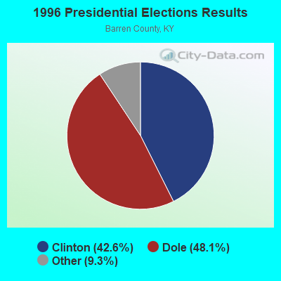
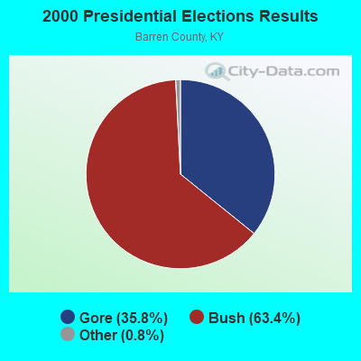


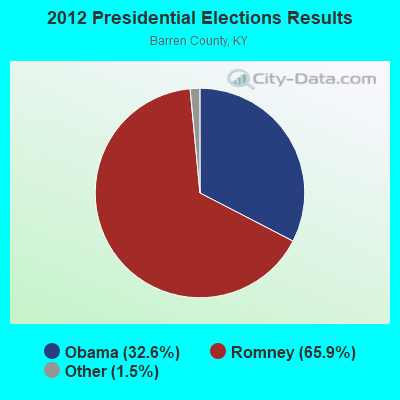
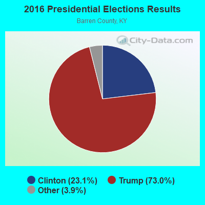
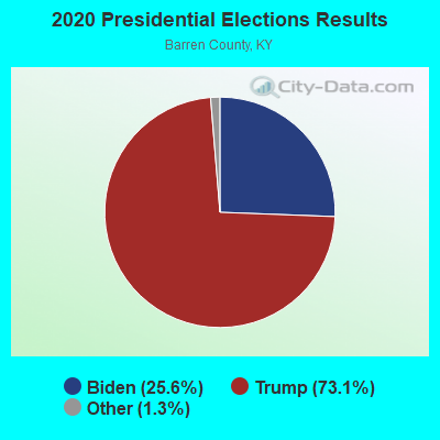
Graphs represent county-level data. Detailed 2008 Election Results
Religion statistics for Temple Hill, KY (based on Barren County data)
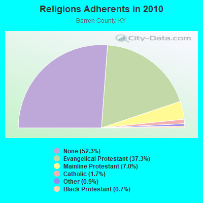
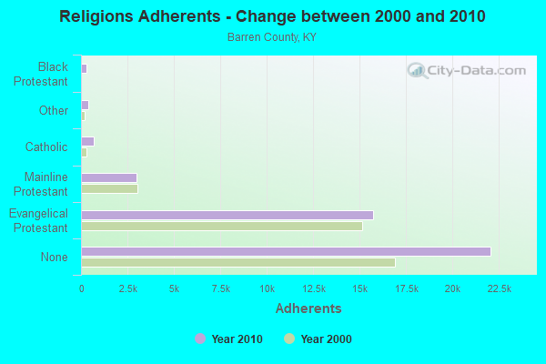
| Religion | Adherents | Congregations |
|---|---|---|
| Evangelical Protestant | 15,741 | 59 |
| Mainline Protestant | 2,965 | 19 |
| Catholic | 704 | 1 |
| Other | 384 | 2 |
| Black Protestant | 307 | 1 |
| None | 22,072 | - |
Food Environment Statistics:
| Barren County: | 2.43 / 10,000 pop. |
| Kentucky: | 2.19 / 10,000 pop. |
| Barren County: | 0.73 / 10,000 pop. |
| Kentucky: | 0.74 / 10,000 pop. |
| Barren County: | 7.06 / 10,000 pop. |
| Kentucky: | 4.36 / 10,000 pop. |
| Barren County: | 7.30 / 10,000 pop. |
| State: | 5.74 / 10,000 pop. |
| Barren County: | 12.9% |
| Kentucky: | 11.0% |
| Barren County: | 28.2% |
| State: | 30.0% |
| Barren County: | 19.3% |
| State: | 15.9% |
Strongest AM radio stations in Temple Hill:
- WSM (650 AM; 50 kW; NASHVILLE, TN; Owner: GAYLORD ENTERTAINMENT COMPANY)
- WAMB (1160 AM; 50 kW; DONELSON, TN; Owner: GREAT SOUTHERN BROADCASTING COMPANY, INC.)
- WTKY (1370 AM; daytime; 2 kW; TOMPKINSVILLE, KY; Owner: WHITTIMORE ENTERPRISES, INC.)
- WCLU (1490 AM; 1 kW; GLASGOW, KY; Owner: ROYSE RADIO, INC.)
- WKDA (1200 AM; 50 kW; NASHVILLE, TN; Owner: RADIO NASHVILLE, INC.)
- WLAC (1510 AM; 50 kW; NASHVILLE, TN; Owner: CAPSTAR TX LIMITED PARTNERSHIP)
- WNQM (1300 AM; 50 kW; NASHVILLE, TN; Owner: WNQM. INC.)
- WHAS (840 AM; 50 kW; LOUISVILLE, KY; Owner: CLEAR CHANNEL BROADCASTING LICENSES, INC.)
- WKVL (850 AM; daytime; 50 kW; KNOXVILLE, TN; Owner: HORNE RADIO, LLC)
- WKCT (930 AM; 5 kW; BOWLING GREEN, KY; Owner: DAILY NEWS BROADCASTING CO.)
- WWAM (820 AM; daytime; 50 kW; JASPER, TN; Owner: SHELTON BROADCASTING SYSTEM)
- WCDS (1440 AM; 0 kW; GLASGOW, KY; Owner: NEWBERRY BROADCASTING, INC.)
- WFLI (1070 AM; 50 kW; LOOKOUT MOUNTAIN, TN; Owner: WFLI, INC.)
Strongest FM radio stations in Temple Hill:
- WOVO (105.3 FM; GLASGOW, KY; Owner: NEWBERRY BROADCASTING, INC.)
- WGBV (94.1 FM; GLASGOW, KY; Owner: FOREVER COMMUNICATIONS,INC.)
- WTKY-FM (92.1 FM; TOMPKINSVILLE, KY; Owner: WHITTIMORE ENTERPRISES, INC.)
- WSGP (88.3 FM; GLASGOW, KY; Owner: SOMERSET EDUCATIONAL BROADCASTING FOUNDATION)
- WGGC (95.1 FM; GLASGOW, KY; Owner: HERITAGE COMMUNICATIONS, INC.)
- WPTQ (103.7 FM; CAVE CITY, KY; Owner: NEWBERRY BROADCASTING, INC.)
- WHHT (106.7 FM; HORSE CAVE, KY; Owner: NEWBERRY BROADCASTING, INC.)
- WKWY (102.7 FM; TOMPKINSVILLE, KY; Owner: J.K. WHITTIMORE)
- WKNK (99.1 FM; EDMONTON, KY; Owner: HART COUNTY COMMUNICATIONS, INC.)
- WCLU-FM (102.3 FM; MUNFORDVILLE, KY; Owner: ROYSE RADIO, INC)
- WDNS (93.3 FM; BOWLING GREEN, KY; Owner: DAILY NEWS BROADCASTING COMPANY)
- WKLX (100.7 FM; BROWNSVILLE, KY; Owner: CHARLES M. ANDERSON)
- WUHU (107.1 FM; SMITHS GROVE, KY; Owner: FOREVER COMMUNICATIONS INC)
- WVLE (99.3 FM; SCOTTSVILLE, KY; Owner: SHERANDAN BROADCASTING COMPANY, INC.)
- WKYR-FM (107.9 FM; BURKESVILLE, KY; Owner: RAY MULLINIX)
TV broadcast stations around Temple Hill:
- WPBM-LP (Channel 48; SCOTTSVILLE, KY; Owner: PROCLAIM BROADCASTING, INC.)
- WNKY (Channel 40; BOWLING GREEN, KY; Owner: MMK LICENSE LLC)
- WPGD (Channel 50; HENDERSONVILLE, TN; Owner: TRINITY BROADCASTING NETWORK)

- 43.2%Electricity
- 40.2%Bottled, tank, or LP gas
- 10.1%Wood
- 5.8%Utility gas
- 0.7%Fuel oil, kerosene, etc.

- 44.8%Electricity
- 36.6%Bottled, tank, or LP gas
- 8.8%Utility gas
- 7.2%Wood
- 2.6%Fuel oil, kerosene, etc.
Temple Hill compared to Kentucky state average:
- Unemployed percentage significantly below state average.
- Black race population percentage significantly below state average.
- Hispanic race population percentage significantly below state average.
- Median age below state average.
- Foreign-born population percentage significantly below state average.
- Renting percentage below state average.
- Length of stay since moving in significantly above state average.
- Number of rooms per house significantly below state average.
- House age significantly below state average.
- Percentage of population with a bachelor's degree or higher significantly below state average.