Turnersville, Texas
Submit your own pictures of this place and show them to the world
- OSM Map
- General Map
- Google Map
- MSN Map

| Males: 1,488 | |
| Females: 600 |
| Median resident age: | 24.5 years |
| Texas median age: | 32.3 years |
Zip code: 76528
| Turnersville: | $75,145 |
| TX: | $72,284 |
Estimated per capita income in 2022: $40,611 (it was $19,853 in 2000)
Turnersville CCD income, earnings, and wages data
Estimated median house or condo value in 2022: $172,287 (it was $66,500 in 2000)
| Turnersville: | $172,287 |
| TX: | $275,400 |
Mean prices in 2022: all housing units: $237,248; detached houses: $243,391; townhouses or other attached units: $232,664; in 2-unit structures: $134,782; in 5-or-more-unit structures: $150,229; mobile homes: $186,802; occupied boats, rvs, vans, etc.: $72,290
Detailed information about poverty and poor residents in Turnersville, TX


- 1,46167.7%White alone
- 41619.3%Black alone
- 2039.4%Hispanic
- 291.3%Asian alone
- 200.9%Two or more races
- 160.7%American Indian alone
- 90.4%Native Hawaiian and Other
Pacific Islander alone - 40.2%Other race alone

Races in Turnersville detailed stats: ancestries, foreign born residents, place of birth
 Recent articles from our blog. Our writers, many of them Ph.D. graduates or candidates, create easy-to-read articles on a wide variety of topics.
Current Local Time: CST time zone
Land area: 135.2 square miles.
Population density: 15 people per square mile (very low).

| Turnersville CCD: | 0.7% ($441) |
| Texas: | 1.8% ($1,393) |
Nearest city with pop. 50,000+: Killeen, TX  (34.7 miles , pop. 86,911).
Nearest city with pop. 200,000+: Fort Worth, TX (82.3 miles , pop. 534,694).
Nearest city with pop. 1,000,000+: Dallas, TX (100.4 miles , pop. 1,188,580).
Nearest cities:
), ), ), ), )Latitude: 31.61 N, Longitude: 97.76 W
Area code: 254


| Here: | 3.8% |
| Texas: | 3.5% |

- Agriculture, forestry, fishing & hunting (25.0%)
- Public administration (21.0%)
- Educational services (10.3%)
- Health care (9.0%)
- Construction (7.6%)
- Transportation equipment (2.3%)
- Finance & insurance (2.3%)

- Agriculture, forestry, fishing & hunting (33.5%)
- Public administration (16.3%)
- Construction (12.8%)
- Educational services (7.0%)
- Finance & insurance (2.9%)
- Nonmetallic mineral products (2.6%)
- Transportation equipment (2.6%)
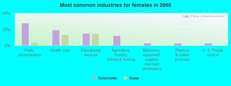
- Public administration (28.0%)
- Health care (19.4%)
- Educational services (15.2%)
- Agriculture, forestry, fishing & hunting (12.3%)
- Machinery, equipment, supplies merchant wholesalers (3.3%)
- Plastics & rubber products (3.3%)
- U. S. Postal service (3.3%)

- Farmers and farm managers (15.6%)
- Law enforcement workers, including supervisors (7.4%)
- Agricultural workers, including supervisors (6.9%)
- Other office and administrative support workers, including supervisors (6.7%)
- Health technologists and technicians (5.5%)
- Preschool, kindergarten, elementary, and middle school teachers (5.2%)
- Pipelayers, plumbers, pipefitters, and steamfitters (3.8%)

- Farmers and farm managers (20.8%)
- Agricultural workers, including supervisors (11.5%)
- Pipelayers, plumbers, pipefitters, and steamfitters (6.4%)
- Law enforcement workers, including supervisors (5.4%)
- Other office and administrative support workers, including supervisors (5.1%)
- Metal workers and plastic workers (5.1%)
- Electricians (4.8%)

- Law enforcement workers, including supervisors (10.4%)
- Health technologists and technicians (10.0%)
- Preschool, kindergarten, elementary, and middle school teachers (9.0%)
- Other office and administrative support workers, including supervisors (9.0%)
- Farmers and farm managers (8.1%)
- Material recording, scheduling, dispatching, and distributing workers (6.6%)
- Information and record clerks, except customer service representatives (5.7%)
Average climate in Turnersville, Texas
Based on data reported by over 4,000 weather stations


Tornado activity:
Turnersville-area historical tornado activity is slightly above Texas state average. It is 77% greater than the overall U.S. average.
On 5/6/1973, a category F5 (max. wind speeds 261-318 mph) tornado 16.7 miles away from the Turnersville place center .
On 5/11/1953, a category F5 tornado 36.3 miles away from the place center killed 114 people and injured 597 people and caused between $5,000,000 and $50,000,000 in damages.
Earthquake activity:
Turnersville-area historical earthquake activity is significantly above Texas state average. It is 336% greater than the overall U.S. average.On 11/6/2011 at 03:53:10, a magnitude 5.7 (5.7 MW, Depth: 3.2 mi, Class: Moderate, Intensity: VI - VII) earthquake occurred 277.6 miles away from Turnersville center
On 6/16/1978 at 11:46:54, a magnitude 5.3 (4.4 MB, 4.6 UK, 5.3 ML) earthquake occurred 201.3 miles away from the city center
On 9/3/2016 at 12:02:44, a magnitude 5.8 (5.8 MW, Depth: 3.5 mi) earthquake occurred 336.7 miles away from Turnersville center
On 4/14/1995 at 00:32:56, a magnitude 5.7 (5.6 MB, 5.7 MS, 5.7 MW, Depth: 11.1 mi) earthquake occurred 344.8 miles away from Turnersville center
On 10/20/2011 at 12:24:41, a magnitude 4.8 (4.8 MW, Depth: 3.1 mi, Class: Light, Intensity: IV - V) earthquake occurred 190.5 miles away from the city center
On 5/17/2012 at 08:12:00, a magnitude 4.8 (4.8 MW, Depth: 3.1 mi) earthquake occurred 200.8 miles away from the city center
Magnitude types: body-wave magnitude (MB), local magnitude (ML), surface-wave magnitude (MS), moment magnitude (MW)
Natural disasters:
The number of natural disasters in Coryell County (16) is near the US average (15).Major Disasters (Presidential) Declared: 7
Emergencies Declared: 6
Causes of natural disasters: Fires: 6, Storms: 6, Floods: 5, Hurricanes: 3, Tornadoes: 3, Wind: 1, Other: 1 (Note: some incidents may be assigned to more than one category).
Hospitals and medical centers near Turnersville:
- CORYELL MEMORIAL HOSPITAL HOME HEALTH CARE SERVICE (Home Health Center, about 12 miles away; GATESVILLE, TX)
- OSAGE CARE CENTER (Nursing Home, about 12 miles away; GATESVILLE, TX)
- CORYELL MEMORIAL HEALTHCARE SYSTEM Critical Access Hospitals (about 12 miles away; GATESVILLE, TX)
- HILLSIDE MANOR NURSING CENTER (Nursing Home, about 13 miles away; GATESVILLE, TX)
- HILLSIDE NURSING AND REHABILITATION LP (Nursing Home, about 13 miles away; GATESVILLE, TX)
- GOODALL WITCHER HOME HEALTH AGENCY (Home Health Center, about 16 miles away; CLIFTON, TX)
- SUNSET HOME (Nursing Home, about 16 miles away; CLIFTON, TX)
Colleges/universities with over 2000 students nearest to Turnersville:
- Central Texas College (about 34 miles; Killeen, TX; Full-time enrollment: 15,911)
- McLennan Community College (about 35 miles; Waco, TX; FT enrollment: 6,673)
- Baylor University (about 39 miles; Waco, TX; FT enrollment: 14,800)
- Texas State Technical College-Waco (about 41 miles; Waco, TX; FT enrollment: 4,210)
- University of Mary Hardin-Baylor (about 42 miles; Belton, TX; FT enrollment: 2,885)
- Temple College (about 45 miles; Temple, TX; FT enrollment: 3,796)
- Hill College (about 49 miles; Hillsboro, TX; FT enrollment: 2,968)
Points of interest:
Notable locations in Turnersville: Pickens Pool (A), White-Hall (B), Ames Community Center (C), Turnersville Volunteer Fire Department (D), Jonesboro Volunteer Fire Department (E). Display/hide their locations on the map
Churches in Turnersville include: Ames Church (A), Liberty Church (B). Display/hide their locations on the map
Cemeteries: Weaver Chapel Cemetery (1), Turnersville Cemetery (2), Young Cemetery (3), Prairie View Cemetery (4), Wood Cemetery (5), Post Oak Cemetery (6). Display/hide their locations on the map
Reservoir: Mom Grazing Association Lake (A). Display/hide its location on the map
Streams, rivers, and creeks: South Fork Hog Creek (A), Kelly Branch (B), Hurst Branch (C), Plum Creek (D), Goldys Branch (E), Thorp Branch (F), Pickens Branch (G), Eagle Creek (H). Display/hide their locations on the map
Birthplace of: Ewing Y. Freeland - Football player and coach.
| This place: | 2.5 people |
| Texas: | 2.8 people |
| This place: | 76.5% |
| Whole state: | 69.9% |
| This place: | 5.3% |
| Whole state: | 6.0% |
Likely homosexual households (counted as self-reported same-sex unmarried-partner households)
- Lesbian couples: 0.5% of all households
- Gay men: 0.5% of all households
| This place: | 6.8% |
| Whole state: | 15.4% |
| This place: | 1.9% |
| Whole state: | 6.7% |
For population 15 years and over in Turnersville:

- Never married: 50.1%
- Now married: 41.2%
- Separated: 1.2%
- Widowed: 2.7%
- Divorced: 6.0%
For population 25 years and over in Turnersville:
- High school or higher: 89.6%
- Bachelor's degree or higher: 19.3%
- Graduate or professional degree: 7.9%
- Unemployed: 5.8%
- Mean travel time to work (commute): 16.8 minutes


| Here: | 9.8 |
| Texas average: | 15.6 |
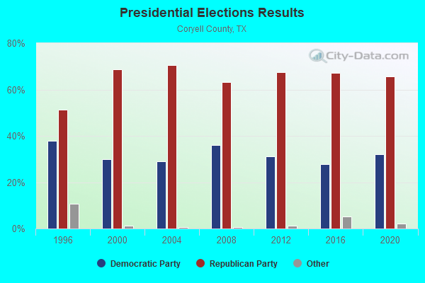
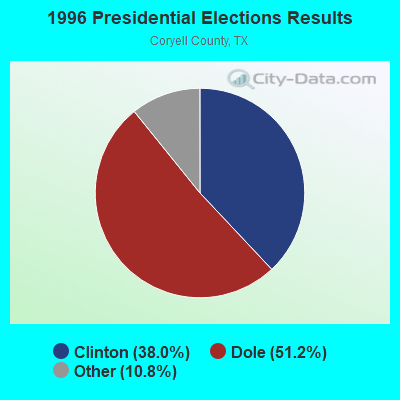

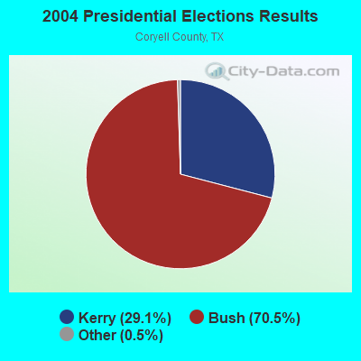
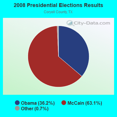

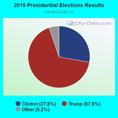
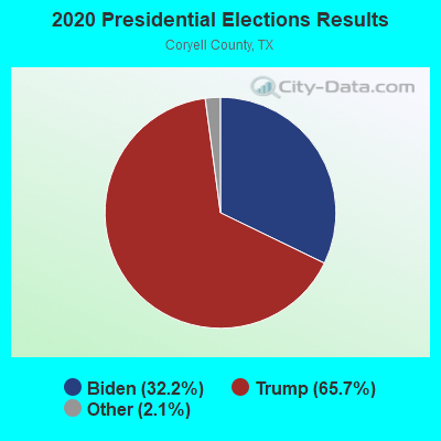
Graphs represent county-level data. Detailed 2008 Election Results
Religion statistics for Turnersville, TX (based on Coryell County data)
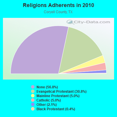
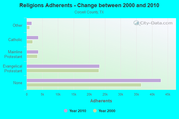
| Religion | Adherents | Congregations |
|---|---|---|
| Evangelical Protestant | 23,206 | 80 |
| Mainline Protestant | 3,749 | 14 |
| Catholic | 3,735 | 2 |
| Other | 1,574 | 6 |
| Black Protestant | 291 | 2 |
| None | 42,833 | - |
Food Environment Statistics:
| Here: | 0.69 / 10,000 pop. |
| Texas: | 1.47 / 10,000 pop. |
| Here: | 0.14 / 10,000 pop. |
| Texas: | 0.14 / 10,000 pop. |
| This county: | 0.28 / 10,000 pop. |
| State: | 1.11 / 10,000 pop. |
| Coryell County: | 2.36 / 10,000 pop. |
| State: | 3.95 / 10,000 pop. |
| This county: | 3.05 / 10,000 pop. |
| Texas: | 6.13 / 10,000 pop. |
| Coryell County: | 7.8% |
| State: | 8.9% |
| Here: | 27.0% |
| Texas: | 26.6% |
| Coryell County: | 7.3% |
| State: | 15.7% |
18.00% of this county's 2021 resident taxpayers lived in other counties in 2020 ($40,558 average adjusted gross income)
| Here: | 18.00% |
| Texas average: | 8.12% |
0.45% of residents moved from foreign countries ($1,164 average AGI)
Coryell County: 0.45% Texas average: 0.04%
Top counties from which taxpayers relocated into this county between 2020 and 2021:
| from Bell County, TX | |
| from Lampasas County, TX | |
| from McLennan County, TX |
15.75% of this county's 2020 resident taxpayers moved to other counties in 2021 ($41,019 average adjusted gross income)
| Here: | 15.75% |
| Texas average: | 7.40% |
0.29% of residents moved to foreign countries ($979 average AGI)
Coryell County: 0.29% Texas average: 0.03%
Top counties to which taxpayers relocated from this county between 2020 and 2021:
| to Bell County, TX | |
| to Lampasas County, TX | |
| to McLennan County, TX |
Strongest AM radio stations in Turnersville:
- WBAP (820 AM; 50 kW; FORT WORTH, TX; Owner: WBAP-KSCS OPERATING, LTD.)
- KESS (1270 AM; 50 kW; FORT WORTH, TX; Owner: KESS-AM LICENSE CORP.)
- KAHZ (1360 AM; 50 kW; HURST, TX)
- KRZX (1660 AM; 10 kW; WACO, TX; Owner: VAN D. GOODALL, JR.)
- KBBW (1010 AM; 10 kW; WACO-MARLIN, TX; Owner: AMERICAN BROADCASTING OF TEXAS)
- KRZI (1580 AM; 10 kW; WACO, TX; Owner: VAN D. GOODALL, JR.)
- KRLD (1080 AM; 50 kW; DALLAS, TX; Owner: TEXAS INFINITY BROADCASTING L.P.)
- KZMP (1540 AM; 50 kW; UNIVERSITY PARK, TX; Owner: ENTRAVISION HOLDINGS, LLC)
- KFXR (1190 AM; 50 kW; DALLAS, TX; Owner: CLEAR CHANNEL BROADCASTING LICENSES, INC.)
- KSKY (660 AM; 20 kW; BALCH SPRINGS, TX; Owner: BISON MEDIA, INC.)
- KKYX (680 AM; 50 kW; SAN ANTONIO, TX; Owner: CXR HOLDINGS, INC.)
- KTKR (760 AM; 50 kW; SAN ANTONIO, TX; Owner: CCB TEXAS LICENSES, L.P.)
- KBIS (1150 AM; 25 kW; HIGHLAND PARK, TX; Owner: DALLAS AM RADIO PARTNERS, L.P.)
Strongest FM radio stations in Turnersville:
- WACO-FM (99.9 FM; WACO, TX; Owner: CAPSTAR TX LIMITED PARTNERSHIP)
- KWOW (104.1 FM; CLIFTON, TX; Owner: M&M BROADCASTERS, LTD.)
- KWTX-FM (97.5 FM; WACO, TX; Owner: CAPSTAR TX LIMITED PARTNERSHIP)
- KBGO (95.7 FM; WACO, TX; Owner: CAPSTAR TX LIMITED PARTNERSHIP)
- KDHT (93.3 FM; CEDAR PARK, TX; Owner: EMMIS AUSTIN RADIO BROADCASTING COMPANY, L.P.)
- KTFW-FM (92.1 FM; GLEN ROSE, TX; Owner: M&M BROADCASTERS, LTD.)
- KVLZ (98.3 FM; GATESVILLE, TX; Owner: EDUCATIONAL MEDIA FOUNDATION)
- KNCT-FM (91.3 FM; KILLEEN, TX; Owner: CENTRAL TEXAS COLLEGE)
TV broadcast stations around Turnersville:
- KXXV (Channel 25; WACO, TX; Owner: CENTEX TELEVISION LIMITED PARTNERSHIP)
- KWKT (Channel 44; WACO, TX; Owner: COMCORP OF TEXAS LICENSE CORP.)
- KWTX-TV (Channel 10; WACO, TX; Owner: KWTX-KBTX LICENSEE CORP.)
- KCEN-TV (Channel 6; TEMPLE, TX; Owner: CHANNEL 6, INC.)
- KWBU-TV (Channel 34; WACO, TX; Owner: BRAZOS VALLEY PUBLIC BROADCASTING FOUNDATION)
- KNCT (Channel 46; BELTON, TX; Owner: CENTRAL TEXAS COLLEGE)
FCC Registered Microwave Towers:
6- Turnersville, Lat: 31.633528 Lon: -97.759278, Type: Ltower, Structure height: 57 m, Overall height: 57.9 m, Call Sign: WQJC218,
Assigned Frequencies: 3650.00 MHz, Grant Date: 07/25/2018, Expiration Date: 10/17/2020, Cancellation Date: 12/19/2020, Certifier: Douglas Campbell, Registrant: Ama Techtel Communications, 7201 I-40w, Suite 200, Lubbock, TX 79464, Phone: (806) 722-2247, Fax: (806) 322-2121, Email:
- Turnersville, Lat: 31.633528 Lon: -97.759278, Type: Ltower, Structure height: 57 m, Overall height: 57.9 m, Call Sign: WQJC218,
Assigned Frequencies: 3650.00 MHz, Grant Date: 07/25/2018, Expiration Date: 10/17/2020, Cancellation Date: 12/19/2020, Certifier: Douglas Campbell, Registrant: Ama Techtel Communications, 7201 I-40w, Suite 200, Lubbock, TX 79464, Phone: (806) 722-2247, Fax: (806) 322-2121, Email:
- TURNERSVILLE, S. Turnersville Rd (Lat: 30.073056 Lon: -97.782944), Type: Ltower, Structure height: 59 m, Overall height: 59.4 m, Call Sign: WRZG257,
Assigned Frequencies: 11605.0 MHz, 11605.0 MHz, 11605.0 MHz, 11605.0 MHz, 11605.0 MHz, 11605.0 MHz, 11605.0 MHz, 11605.0 MHz, 11605.0 MHz, 11605.0 MHz, Grant Date: 10/30/2023, Expiration Date: 10/30/2033, Certifier: Michael A Nunez, Registrant: Lower Colorado River Authority, 3505 Montopolis Drive, Austin, TX 78744-1499, Phone: (512) 730-8918, Email:
- TURNERSVILL, Lat: 31.617917 Lon: -97.741111, Overall height: 45.7 m, Call Sign: WCU577, Licensee ID: L00121008,
Assigned Frequencies: 2121.60 MHz, Grant Date: 03/22/2001, Expiration Date: 02/01/2011, Cancellation Date: 04/08/2004, Registrant: Central Telephone Company Of Texas Inc

- 52.5%Bottled, tank, or LP gas
- 38.0%Electricity
- 6.3%Wood
- 3.2%Utility gas

- 63.3%Bottled, tank, or LP gas
- 36.7%Electricity
Turnersville compared to Texas state average:
- Median house value below state average.
- Unemployed percentage below state average.
- Hispanic race population percentage significantly below state average.
- Median age below state average.
- Foreign-born population percentage significantly below state average.
- Renting percentage below state average.
- Length of stay since moving in significantly above state average.
- Number of rooms per house significantly below state average.
- House age significantly below state average.
Turnersville on our top lists:
- #4 on the list of "Top 101 cities with the largest percentage of people in military barracks, etc. (population 1,000+)"
- #3 on the list of "Top 101 counties with the highest percentage of residents relocating from other counties between 2010 and 2011 (pop. 50,000+)"
- #3 on the list of "Top 101 counties with the highest percentage of residents relocating to other counties in 2011 (pop. 50,000+)"
- #4 on the list of "Top 101 counties with the highest percentage of residents relocating to foreign countries in 2011 (pop. 50,000+)"
- #6 on the list of "Top 101 counties with the lowest total withdrawal of fresh water for public supply (pop. 50,000+)"
- #7 on the list of "Top 101 counties with the highest percentage of residents relocating from foreign countries between 2010 and 2011 (pop. 50,000+)"