Upper Siuslaw, Oregon
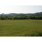
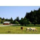
Upper Siuslaw: Pasture...
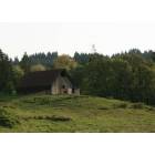
Upper Siuslaw: Barn on a hill....

Upper Siuslaw: Inpenetrable.....
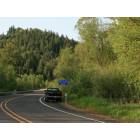
Upper Siuslaw: Gimpl Hill RD.....
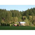
Upper Siuslaw: Farm in the hills.....
Upper Siuslaw: Grazing....
- add
your
Submit your own pictures of this place and show them to the world
- OSM Map
- General Map
- Google Map
- MSN Map

| Males: 881 | |
| Females: 907 |
| Median resident age: | 41.3 years |
| Oregon median age: | 36.3 years |
Zip code: 97487
| Upper Siuslaw: | $68,649 |
| OR: | $75,657 |
Estimated per capita income in 2022: $35,070 (it was $19,282 in 2000)
Upper Siuslaw CCD income, earnings, and wages data
Estimated median house or condo value in 2022: $513,105 (it was $160,900 in 2000)
| Upper Siuslaw: | $513,105 |
| OR: | $475,600 |
Mean prices in 2022: all housing units: $467,161; detached houses: $507,773; townhouses or other attached units: $393,851; in 2-unit structures: $407,947; in 3-to-4-unit structures: $352,759; in 5-or-more-unit structures: $252,275; mobile homes: $154,945; occupied boats, rvs, vans, etc.: $16,903
Detailed information about poverty and poor residents in Upper Siuslaw, OR


- 1,59294.9%White alone
- 422.5%Two or more races
- 201.2%American Indian alone
- 140.8%Hispanic
- 50.3%Black alone
- 40.2%Asian alone
- 10.06%Native Hawaiian and Other
Pacific Islander alone

Races in Upper Siuslaw detailed stats: ancestries, foreign born residents, place of birth
 Recent articles from our blog. Our writers, many of them Ph.D. graduates or candidates, create easy-to-read articles on a wide variety of topics.
Current Local Time: PST time zone
Land area: 302.9 square miles.
Population density: 5.9 people per square mile (very low).

| Upper Siuslaw CCD: | 0.6% ($1,024) |
| Oregon: | 1.2% ($1,687) |
Nearest city with pop. 50,000+: Eugene, OR  (18.8 miles , pop. 137,893).
Nearest city with pop. 200,000+: Northwest Clackamas, OR (110.3 miles , pop. 224,220).
Nearest city with pop. 1,000,000+: Los Angeles, CA (731.4 miles , pop. 3,694,820).
Nearest cities:
), ), Latitude: 43.91 N, Longitude: 123.43 W
Area code commonly used in this area: 541


| Here: | 4.2% |
| Oregon: | 3.9% |

- Construction (13.3%)
- Agriculture, forestry, fishing & hunting (12.2%)
- Health care (10.0%)
- Wood products (6.8%)
- Educational services (6.2%)
- Food & beverage stores (4.9%)
- Professional, scientific, technical services (4.4%)

- Agriculture, forestry, fishing & hunting (18.1%)
- Construction (16.9%)
- Wood products (9.9%)
- Health care (6.7%)
- Beverage & tobacco products (6.5%)
- Administrative & support & waste management services (4.2%)
- Repair & maintenance (3.6%)

- Educational services (16.4%)
- Health care (15.4%)
- Food & beverage stores (10.7%)
- Professional, scientific, technical services (9.4%)
- Construction (7.2%)
- Department & other general merchandise stores (4.1%)
- Electronic shopping & mail-order houses (3.5%)

- Other production occupations, including supervisors (8.1%)
- Other management occupations, except farmers and farm managers (5.0%)
- Agricultural workers, including supervisors (4.3%)
- Material recording, scheduling, dispatching, and distributing workers (3.8%)
- Other sales and related occupations, including supervisors (3.7%)
- Farmers and farm managers (3.6%)
- Electrical equipment mechanics and other installation, maintenance, and repair workers, including supervisors (3.3%)

- Other production occupations, including supervisors (12.0%)
- Farmers and farm managers (5.7%)
- Other management occupations, except farmers and farm managers (5.7%)
- Vehicle and mobile equipment mechanics, installers, and repairers (5.3%)
- Top executives (4.4%)
- Metal workers and plastic workers (4.4%)
- Electrical equipment mechanics and other installation, maintenance, and repair workers, including supervisors (4.2%)

- Secretaries and administrative assistants (6.9%)
- Material recording, scheduling, dispatching, and distributing workers (6.9%)
- Registered nurses (5.3%)
- Therapists (4.7%)
- Cashiers (4.7%)
- Information and record clerks, except customer service representatives (4.4%)
- Other sales and related occupations, including supervisors (4.4%)
Average climate in Upper Siuslaw, Oregon
Based on data reported by over 4,000 weather stations


(lower is better)

Air Quality Index (AQI) level in 2023 was 92.6. This is worse than average.
| City: | 92.6 |
| U.S.: | 72.6 |

Carbon Monoxide (CO) [ppm] level in 2010 was 0.410. This is significantly worse than average. Closest monitor was 18.9 miles away from the city center.
| City: | 0.410 |
| U.S.: | 0.251 |


Particulate Matter (PM10) [µg/m3] level in 2022 was 16.0. This is about average. Closest monitor was 17.4 miles away from the city center.
| City: | 16.0 |
| U.S.: | 19.2 |

Particulate Matter (PM2.5) [µg/m3] level in 2023 was 6.02. This is better than average. Closest monitor was 17.9 miles away from the city center.
| City: | 6.02 |
| U.S.: | 8.11 |

Lead (Pb) [µg/m3] level in 2003 was 0.00258. This is significantly better than average. Closest monitor was 18.9 miles away from the city center.
| City: | 0.00258 |
| U.S.: | 0.00931 |
Earthquake activity:
Upper Siuslaw-area historical earthquake activity is significantly above Oregon state average. It is 2354% greater than the overall U.S. average.On 1/31/1922 at 13:17:28, a magnitude 7.6 (7.6 UK, Class: Major, Intensity: VIII - XII) earthquake occurred 247.2 miles away from the city center
On 11/8/1980 at 10:27:34, a magnitude 7.2 (6.2 MB, 7.2 MS, 7.2 MW, 7.0 ML) earthquake occurred 198.7 miles away from Upper Siuslaw center
On 8/17/1991 at 22:17:14, a magnitude 7.1 (6.2 MB, 7.1 MS, 7.1 MW, 6.8 ML, Depth: 8.4 mi) earthquake occurred 185.3 miles away from the city center
On 6/15/2005 at 02:50:54, a magnitude 7.2 (7.2 MW, Depth: 9.9 mi) earthquake occurred 222.1 miles away from the city center
On 6/15/2005 at 02:50:54, a magnitude 7.2 (6.1 MB, 7.1 MS, 7.2 MW, 7.1 MW) earthquake occurred 228.1 miles away from the city center
On 7/13/1991 at 02:50:14, a magnitude 6.9 (6.2 MB, 6.9 MS, 6.8 MW, 6.7 ML, Depth: 6.8 mi, Class: Strong, Intensity: VII - IX) earthquake occurred 166.9 miles away from the city center
Magnitude types: body-wave magnitude (MB), local magnitude (ML), surface-wave magnitude (MS), moment magnitude (MW)
Natural disasters:
The number of natural disasters in Lane County (17) is near the US average (15).Major Disasters (Presidential) Declared: 13
Emergencies Declared: 1
Causes of natural disasters: Floods: 10, Winter Storms: 7, Storms: 6, Winds: 4, Landslides: 3, Mudslides: 3, Fire: 1, Heavy Rain: 1, Hurricane: 1, Snow: 1, Other: 1 (Note: some incidents may be assigned to more than one category).
Amtrak stations near Upper Siuslaw:
- 20 miles: EUGENE-SPRINGFIELD (EUGENE, 433 WILLAMETTE ST.) . Services: ticket office, partially wheelchair accessible, enclosed waiting area, public restrooms, public payphones, full-service food facilities, paid short-term parking, call for car rental service, call for taxi service, public transit connection.
- 20 miles: COTTAGE GROVE (1140 N. STATE HWY 99) - Bus Station . Services: public payphones, full-service food facilities, free short-term parking.
Colleges/universities with over 2000 students nearest to Upper Siuslaw:
- University of Oregon (about 20 miles; Eugene, OR; Full-time enrollment: 23,329)
- Lane Community College (about 21 miles; Eugene, OR; FT enrollment: 6,373)
- Oregon State University (about 46 miles; Corvallis, OR; FT enrollment: 23,206)
- Linn-Benton Community College (about 50 miles; Albany, OR; FT enrollment: 4,511)
- Western Oregon University (about 66 miles; Monmouth, OR; FT enrollment: 5,131)
- Willamette University (about 74 miles; Salem, OR; FT enrollment: 2,551)
- Chemeketa Community College (about 78 miles; Salem, OR; FT enrollment: 10,746)
Points of interest:
Notable locations in Upper Siuslaw: Lorane Guard Station (A), King Ranch (B), Siuslaw Guard Station (C), Walton Guard Station (D), Gillespie Corners (E), Globe (F), Richardson (G), Whittaker Creek Timber Pole Slide (H), Richardson Pole Slide (I), Wolf Creek Store (J), Linslaw Park Boat Ramp (K), Ford Access Boat Ramp (L), Turner Creek Camp (M), Austa Boat Ramp (N), Lane County Fire District 1 Station 18 - 2 (O), Lorane Rural Fire Protection District (P), Lane County Fire District 1 Station 18 - 4 (Q). Display/hide their locations on the map
Cemeteries: Linslaw Cemetery (1), Heatherly Cemetery (2), Crow Family Cemetery (3), Independent Order of Good Templars Cemetery (4), Lorane Grange Cemetery (5). Display/hide their locations on the map
Reservoirs: Farnam Creek Reservoir (A), Smith Reservoir (B), Clay Creek Recreational Reservoir (C), Whittaker Creek Recreational Reservoir (D). Display/hide their locations on the map
Streams, rivers, and creeks: Kirk Creek (A), Sutherland Creek (B), Preston Creek (C), Haskins Creek (D), Esmond Creek (E), Big Canyon Creek (F), Bounds Creek (G), Battle Creek (H), Schoolhouse Creek (I). Display/hide their locations on the map
Parks in Upper Siuslaw include: Clay Creek Recreation Site (1), Haight Creek Picnic Area (2), Siuslaw Falls County Park (3), Camp Lane (4), Whittaker Creek Recreation Site (5), Linslaw County Park (6), Camp Lane County Park (7), Austa Landing County Park (8). Display/hide their locations on the map
| This place: | 2.7 people |
| Oregon: | 2.5 people |
| This place: | 63.5% |
| Whole state: | 66.3% |
| This place: | 6.8% |
| Whole state: | 6.3% |
Likely homosexual households (counted as self-reported same-sex unmarried-partner households)
- Lesbian couples: 1.3% of all households
- Gay men: 0.0% of all households
| This place: | 9.1% |
| Whole state: | 11.6% |
| This place: | 4.3% |
| Whole state: | 5.0% |
For population 15 years and over in Upper Siuslaw:

- Never married: 22.2%
- Now married: 59.7%
- Separated: 1.0%
- Widowed: 3.8%
- Divorced: 14.2%
For population 25 years and over in Upper Siuslaw:
- High school or higher: 86.2%
- Bachelor's degree or higher: 28.1%
- Graduate or professional degree: 8.2%
- Unemployed: 6.0%
- Mean travel time to work (commute): 28.9 minutes


| Here: | 10.0 |
| Oregon average: | 11.5 |
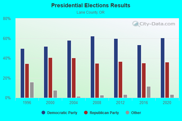
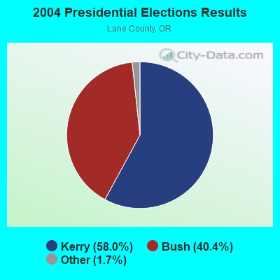
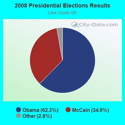
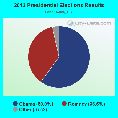
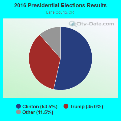
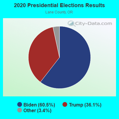
Graphs represent county-level data. Detailed 2008 Election Results
Religion statistics for Upper Siuslaw, OR (based on Lane County data)
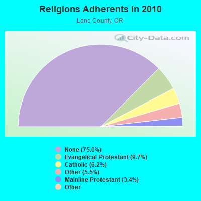
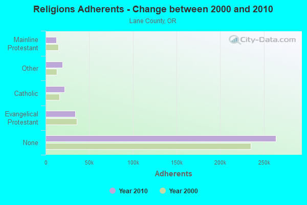
| Religion | Adherents | Congregations |
|---|---|---|
| Evangelical Protestant | 34,051 | 216 |
| Catholic | 21,785 | 15 |
| Other | 19,303 | 72 |
| Mainline Protestant | 12,082 | 50 |
| Black Protestant | 295 | 2 |
| Orthodox | 240 | 2 |
| None | 263,959 | - |
Food Environment Statistics:
| This county: | 1.95 / 10,000 pop. |
| State: | 2.03 / 10,000 pop. |
| This county: | 0.44 / 10,000 pop. |
| Oregon: | 0.33 / 10,000 pop. |
| Lane County: | 2.68 / 10,000 pop. |
| Oregon: | 2.01 / 10,000 pop. |
| Lane County: | 1.69 / 10,000 pop. |
| Oregon: | 1.69 / 10,000 pop. |
| Lane County: | 8.40 / 10,000 pop. |
| Oregon: | 9.93 / 10,000 pop. |
| Lane County: | 6.5% |
| State: | 7.4% |
| Lane County: | 26.1% |
| Oregon: | 25.6% |
| Here: | 15.3% |
| Oregon: | 14.2% |
Strongest AM radio stations in Upper Siuslaw:
- KPNW (1120 AM; 50 kW; EUGENE, OR; Owner: CAPSTAR TX LIMITED PARTNERSHIP)
- KDUN (1030 AM; 50 kW; REEDSPORT, OR; Owner: PAMPLIN BROADCASTING-OREGON, INC.)
- KZTU (660 AM; 10 kW; JUNCTION CITY, OR; Owner: PAMPLIN BROADCASTING-OREGON, INC.)
- KUGN (590 AM; 5 kW; EUGENE, OR; Owner: CUMULUS LICENSING CORP.)
- KGRV (700 AM; 25 kW; WINSTON, OR; Owner: PACIFIC CASCADE COMMUNICATIONS CORP.)
- KORE (1050 AM; 5 kW; SPRINGFIELD-EUGENE, OR; Owner: SUPPORT CHRISTIAN BROADCASTING)
- KEED (1600 AM; 5 kW; EUGENE, OR; Owner: INTEGRITY MEDIA INCORPORATED)
- KRVM (1280 AM; 5 kW; EUGENE, OR; Owner: LANE COUNTY SCHOOL DISTRICT 4J)
- KPOJ (620 AM; 50 kW; PORTLAND, OR; Owner: CITICASTERS LICENSES, L.P.)
- KXL (750 AM; 50 kW; PORTLAND, OR; Owner: ROSE CITY RADIO CORPORATION)
- KPAM (860 AM; 50 kW; TROUTDALE, OR; Owner: PAMPLIN BROADCASTING-OREGON, INC.)
- KEX (1190 AM; 50 kW; PORTLAND, OR; Owner: CITICASTERS LICENSES, L.P.)
- KOAC (550 AM; 5 kW; CORVALLIS, OR; Owner: OREGON PUBLIC BROADCASTING)
Strongest FM radio stations in Upper Siuslaw:
- KKNU (93.1 FM; SPRINGFIELD-EUGENE, OR; Owner: MCKENZIE RIVER BROADCASTING COMPANY, INC.)
- KMGE (94.5 FM; EUGENE, OR; Owner: MCKENZIE RIVER BROADCASTING COMPANY, INC.)
- KUJZ (95.3 FM; CRESWELL, OR; Owner: CUMULUS LICENSING CORP.)
- KDUK-FM (104.7 FM; FLORENCE, OR; Owner: CAPSTAR TX LIMITED PARTNERSHIP)
- KZEL-FM (96.1 FM; EUGENE, OR; Owner: CUMULUS LICENSING CORP.)
- KFLY (101.5 FM; CORVALLIS, OR; Owner: CITICASTERS LICENSES, L.P.)
- KNRQ-FM (97.9 FM; EUGENE, OR; Owner: CUMULUS LICENSING CORP.)
- KWAX (91.1 FM; EUGENE, OR; Owner: STATE OF OREGON ACTING BY & THROUGH)
- KLCC (89.7 FM; EUGENE, OR; Owner: LANE COMMUNITY COLLEGE)
- K207BX (89.3 FM; EUGENE, OR; Owner: PENSACOLA CHRISTIAN COLLEGE, INC.)
- K203BT (88.5 FM; EUGENE, OR; Owner: CALVARY CHAPEL OF TWIN FALLS, INC.)
- K214CI (90.7 FM; EUGENE, OR; Owner: EDUCATIONAL MEDIA FOUNDATION)
- KQFE (88.9 FM; SPRINGFIELD, OR; Owner: FAMILY STATIONS, INC.)
- KODZ (99.1 FM; EUGENE, OR; Owner: CAPSTAR TX LIMITED PARTNERSHIP)
- K245AA (96.9 FM; EUGENE, OR; Owner: ALBANY RADIO CORPORATION)
- K261BF (100.1 FM; BLACK BUTTE, ETC., OR; Owner: FAMILY STATIONS, INC.)
- K265DF (100.9 FM; EUGENE, OR; Owner: EDUCATIONAL MEDIA FOUNDATION)
- KRVM-FM (91.9 FM; EUGENE, OR; Owner: SCHOOL DIST. 4J, LANE COUNTY, OREGON)
- KEUG (105.5 FM; COTTAGE GROVE, OR; Owner: SIGNAL COMMUNICATIONS, INC)
- KWVZ (91.5 FM; FLORENCE, OR; Owner: OREGON STATE BOARD OF HIGHER ED.)
TV broadcast stations around Upper Siuslaw:
- KLSR-TV (Channel 34; EUGENE, OR; Owner: CALIFORNIA OREGON BROADCASTING, INC.)
- KVAL-TV (Channel 13; EUGENE, OR; Owner: FISHER BROADCASTING - OREGON TV, L.L.C.)
- KEPB-TV (Channel 28; EUGENE, OR; Owner: OREGON PUBLIC BROADCASTING)
- KEVU-LP (Channel 23; EUGENE, OR; Owner: CALIFORNIA OREGON BROADCASTING, INC.)
- KAMK-LP (Channel 53; EUGENE, OR; Owner: ROSEBURG BROADCASTING, INC.)
- KMOR-LP (Channel 51; EUGENE, OR; Owner: ACKERLEY MEDIA GROUP, INC.)
- K36FJ (Channel 36; EUGENE, OR; Owner: THREE ANGELS BROADCASTING NETWORK, INC.)
- KMTR (Channel 16; EUGENE, OR; Owner: ACKERLEY MEDIA GROUP, INC.)
- K19EC (Channel 19; MAPLETON, OR; Owner: OREGON PUBLIC BROADCASTING)

- 45.0%Wood
- 35.3%Electricity
- 9.7%Bottled, tank, or LP gas
- 4.8%Fuel oil, kerosene, etc.
- 3.2%Other fuel
- 2.0%Utility gas

- 71.5%Electricity
- 22.6%Wood
- 5.8%Bottled, tank, or LP gas
Upper Siuslaw compared to Oregon state average:
- Unemployed percentage below state average.
- Black race population percentage significantly below state average.
- Hispanic race population percentage significantly below state average.
- Median age above state average.
- Foreign-born population percentage significantly below state average.
- Renting percentage significantly below state average.
- Length of stay since moving in significantly above state average.
- Number of rooms per house significantly below state average.
- House age significantly below state average.