Westville, South Carolina
Submit your own pictures of this place and show them to the world
- OSM Map
- General Map
- Google Map
- MSN Map

| Males: 1,284 | |
| Females: 1,315 |
| Median resident age: | 43.3 years |
| South Carolina median age: | 35.4 years |
Zip code: 29020
| Westville: | $57,601 |
| SC: | $64,115 |
Estimated per capita income in 2022: $39,744 (it was $22,699 in 2000)
Westville CCD income, earnings, and wages data
Estimated median house or condo value in 2022: $207,107 (it was $79,300 in 2000)
| Westville: | $207,107 |
| SC: | $254,600 |
Detailed information about poverty and poor residents in Westville, SC


- 1,63569.6%White alone
- 67128.6%Black alone
- 271.1%Hispanic
- 100.4%Two or more races
- 40.2%Asian alone
- 30.1%American Indian alone

Races in Westville detailed stats: ancestries, foreign born residents, place of birth
 Recent articles from our blog. Our writers, many of them Ph.D. graduates or candidates, create easy-to-read articles on a wide variety of topics.
Current Local Time: EST time zone
Land area: 117.9 square miles.
Population density: 22 people per square mile (very low).

| Westville CCD: | 0.5% ($366) |
| South Carolina: | 0.6% ($510) |
Nearest city with pop. 50,000+: Columbia, SC  (32.4 miles , pop. 116,278).
Nearest city with pop. 200,000+: Charlotte, NC (55.1 miles , pop. 540,828).
Nearest city with pop. 1,000,000+: Philadelphia, PA (493.0 miles , pop. 1,517,550).
Nearest cities:
), ), ), Latitude: 34.42 N, Longitude: 80.72 W
Area code commonly used in this area: 803


| Here: | 3.1% |
| South Carolina: | 3.1% |

- Textile mills & textile products (10.5%)
- Health care (8.7%)
- Educational services (7.4%)
- Finance & insurance (6.7%)
- Department & other general merchandise stores (6.7%)
- Public administration (6.1%)
- Construction (6.0%)

- Construction (10.6%)
- Textile mills & textile products (10.1%)
- Metal & metal products (7.3%)
- Paper (5.2%)
- Transportation equipment (4.4%)
- Public administration (4.4%)
- Utilities (4.2%)

- Health care (15.6%)
- Educational services (14.5%)
- Finance & insurance (11.9%)
- Textile mills & textile products (10.8%)
- Department & other general merchandise stores (9.9%)
- Public administration (8.0%)
- Accommodation & food services (5.9%)

- Other production occupations, including supervisors (5.1%)
- Building and grounds cleaning and maintenance occupations (5.0%)
- Electrical equipment mechanics and other installation, maintenance, and repair workers, including supervisors (4.5%)
- Secretaries and administrative assistants (4.4%)
- Other sales and related occupations, including supervisors (4.4%)
- Other office and administrative support workers, including supervisors (4.2%)
- Driver/sales workers and truck drivers (3.7%)

- Electrical equipment mechanics and other installation, maintenance, and repair workers, including supervisors (8.8%)
- Other production occupations, including supervisors (8.4%)
- Driver/sales workers and truck drivers (7.3%)
- Metal workers and plastic workers (6.9%)
- Building and grounds cleaning and maintenance occupations (5.9%)
- Electricians (5.1%)
- Other sales and related occupations, including supervisors (5.1%)

- Secretaries and administrative assistants (9.0%)
- Other office and administrative support workers, including supervisors (7.4%)
- Preschool, kindergarten, elementary, and middle school teachers (5.9%)
- Textile, apparel, and furnishings workers (5.5%)
- Nursing, psychiatric, and home health aides (4.6%)
- Building and grounds cleaning and maintenance occupations (4.1%)
- Other teachers, instructors, education, training, and library occupations (4.1%)
Average climate in Westville, South Carolina
Based on data reported by over 4,000 weather stations


(lower is better)

Air Quality Index (AQI) level in 2023 was 19.9. This is significantly better than average.
| City: | 19.9 |
| U.S.: | 72.6 |

Nitrogen Dioxide (NO2) [ppb] level in 2023 was 2.97. This is significantly better than average. Closest monitor was 13.1 miles away from the city center.
| City: | 2.97 |
| U.S.: | 5.11 |

Ozone [ppb] level in 2001 was 32.6. This is about average. Closest monitor was 21.7 miles away from the city center.
| City: | 32.6 |
| U.S.: | 33.3 |

Lead (Pb) [µg/m3] level in 2001 was 0.00360. This is significantly better than average. Closest monitor was 13.1 miles away from the city center.
| City: | 0.00360 |
| U.S.: | 0.00931 |
Tornado activity:
Westville-area historical tornado activity is slightly above South Carolina state average. It is 33% greater than the overall U.S. average.
On 3/28/1984, a category F4 (max. wind speeds 207-260 mph) tornado 9.3 miles away from the Westville place center injured 36 people and caused between $5,000,000 and $50,000,000 in damages.
On 3/28/1984, a category F4 tornado 11.7 miles away from the place center killed 5 people and injured 49 people and caused between $5,000,000 and $50,000,000 in damages.
Earthquake activity:
Westville-area historical earthquake activity is significantly above South Carolina state average. It is 28% smaller than the overall U.S. average.On 8/9/2020 at 12:07:37, a magnitude 5.1 (5.1 MW, Depth: 4.7 mi, Class: Moderate, Intensity: VI - VII) earthquake occurred 144.0 miles away from Westville center
On 8/23/2011 at 17:51:04, a magnitude 5.8 (5.8 MW, Depth: 3.7 mi) earthquake occurred 287.1 miles away from the city center
On 8/2/1974 at 08:52:09, a magnitude 4.9 (4.3 MB, 4.9 LG, Class: Light, Intensity: IV - V) earthquake occurred 108.2 miles away from the city center
On 11/22/1974 at 05:25:55, a magnitude 4.7 (4.7 MB) earthquake occurred 109.9 miles away from Westville center
On 8/21/1992 at 16:31:55, a magnitude 4.4 (4.1 MB, 4.1 LG, 4.4 LG, Depth: 6.2 mi) earthquake occurred 100.6 miles away from the city center
On 4/13/1998 at 09:56:11, a magnitude 3.9 (3.5 MB, 3.9 LG, Depth: 3.1 mi, Class: Light, Intensity: II - III) earthquake occurred 19.5 miles away from Westville center
Magnitude types: regional Lg-wave magnitude (LG), body-wave magnitude (MB), moment magnitude (MW)
Natural disasters:
The number of natural disasters in Kershaw County (17) is near the US average (15).Major Disasters (Presidential) Declared: 9
Emergencies Declared: 6
Causes of natural disasters: Hurricanes: 7, Storms: 4, Floods: 3, Winter Storms: 2, Drought: 1, Ice Storm: 1, Tornado: 1, Tropical Storm: 1, Other: 1 (Note: some incidents may be assigned to more than one category).
Hospitals and medical centers near Westville:
- FAIRFIELD HEALTHCARE CENTER, LLC (Nursing Home, about 12 miles away; RIDGEWAY, SC)
- SPRINGDALE HEALTHCARE CENTER (Nursing Home, about 13 miles away; CAMDEN, SC)
- KERSHAWHEALTH HOME HEALTH (Home Health Center, about 13 miles away; CAMDEN, SC)
- HOSPICE OF KERSHAW COUNTY (Hospital, about 13 miles away; CAMDEN, SC)
- CAMDEN I (Hospital, about 13 miles away; CAMDEN, SC)
- CAMDEN II COMMUNITY RESIDENCE (Hospital, about 13 miles away; CAMDEN, SC)
- AMEDISYS HOME HEALTH OF CAMDEN (Home Health Center, about 14 miles away; CAMDEN, SC)
Colleges/universities with over 2000 students nearest to Westville:
- Benedict College (about 34 miles; Columbia, SC; Full-time enrollment: 3,039)
- University of South Carolina-Columbia (about 34 miles; Columbia, SC; FT enrollment: 27,789)
- Central Carolina Technical College (about 39 miles; Sumter, SC; FT enrollment: 3,108)
- York Technical College (about 40 miles; Rock Hill, SC; FT enrollment: 3,572)
- Midlands Technical College (about 40 miles; West Columbia, SC; FT enrollment: 8,916)
- Winthrop University (about 41 miles; Rock Hill, SC; FT enrollment: 5,575)
- Wingate University (about 42 miles; Wingate, NC; FT enrollment: 2,125)
Points of interest:
Notable locations in Westville: Warrens Old Muster Ground (A), Kershaw County Fire Station Beaver Creek (B), Kershaw County Fire Department Westville (C), Kershaw County Fire Station Baron DeKalb (D). Display/hide their locations on the map
Churches in Westville include: Rock Spring Church (A), Saint Johns Church (B), Oak Spring Church (C), Beaver Creek Church (D), Bethel Church (E), Belmont Baptist Church (F), Church of God (G), Damascus Church (H), Ebenezer Church (I). Display/hide their locations on the map
Cemeteries: New Grove Cemetery (1), Beaver Creek Cemetery (2), Duncan Cemetery (3), Smyrles Cemetery (4), White Oak Cemetery (5), Saint Johns Cemetery (6). Display/hide their locations on the map
Reservoirs: Lake Wateree (A), George West Pond (B), Little Barfield Millpond (C), McGuirts Flint Hill Pond (D), Hilton House Pond (E). Display/hide their locations on the map
Streams, rivers, and creeks: White Oak Creek (A), Stillhouse Branch (B), Showerbath Branch (C), Rocky Branch (D), Singleton Creek (E), McDow Creek (F), Tranham Creek (G), Langley Branch (H), Beaver Creek (I). Display/hide their locations on the map
Park in Westville: Liberty Hill Historic District (1). Display/hide its location on the map
Birthplace of: Richmond H. Hilton - Army Medal of Honor recipient.
| This place: | 2.3 people |
| South Carolina: | 2.5 people |
| This place: | 67.3% |
| Whole state: | 67.5% |
| This place: | 5.5% |
| Whole state: | 6.0% |
Likely homosexual households (counted as self-reported same-sex unmarried-partner households)
- Lesbian couples: 0.4% of all households
- Gay men: 0.2% of all households
| This place: | 13.8% |
| Whole state: | 14.1% |
| This place: | 4.5% |
| Whole state: | 6.5% |
For population 15 years and over in Westville:

- Never married: 18.9%
- Now married: 64.9%
- Separated: 2.0%
- Widowed: 8.3%
- Divorced: 7.9%
For population 25 years and over in Westville:
- High school or higher: 73.1%
- Bachelor's degree or higher: 12.2%
- Graduate or professional degree: 3.5%
- Unemployed: 4.6%
- Mean travel time to work (commute): 39.9 minutes


| Here: | 12.4 |
| South Carolina average: | 13.2 |
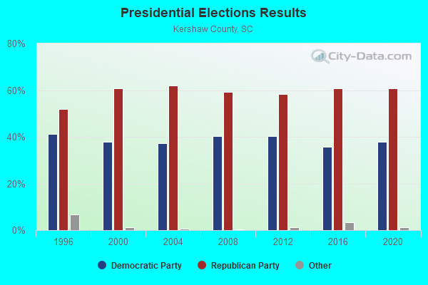
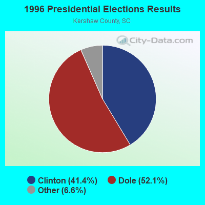
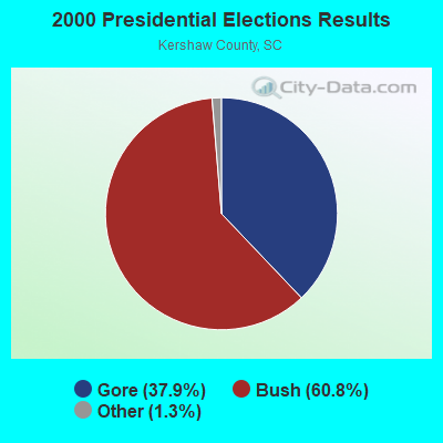
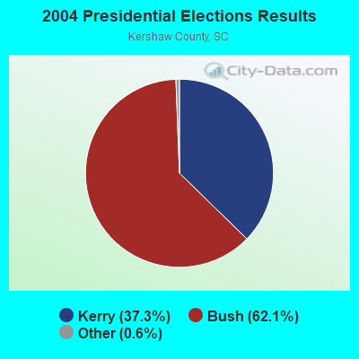
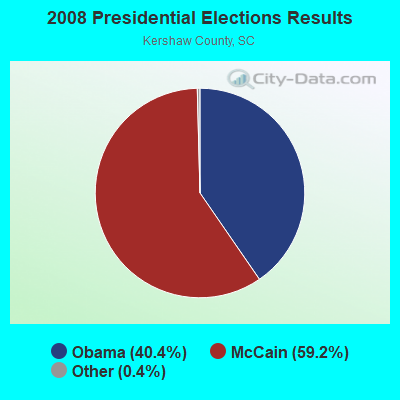


Graphs represent county-level data. Detailed 2008 Election Results
Religion statistics for Westville, SC (based on Kershaw County data)
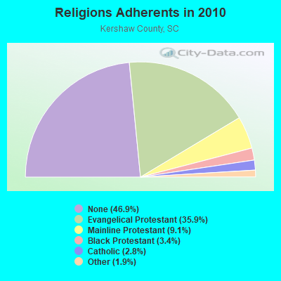
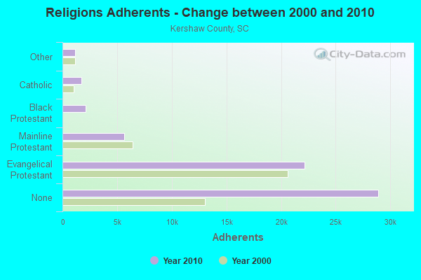
| Religion | Adherents | Congregations |
|---|---|---|
| Evangelical Protestant | 22,139 | 83 |
| Mainline Protestant | 5,627 | 30 |
| Black Protestant | 2,126 | 13 |
| Catholic | 1,724 | 1 |
| Other | 1,166 | 4 |
| None | 28,915 | - |
Food Environment Statistics:
| Kershaw County: | 1.55 / 10,000 pop. |
| State: | 1.99 / 10,000 pop. |
| Here: | 0.17 / 10,000 pop. |
| South Carolina: | 0.15 / 10,000 pop. |
| Kershaw County: | 0.86 / 10,000 pop. |
| South Carolina: | 0.85 / 10,000 pop. |
| Kershaw County: | 5.85 / 10,000 pop. |
| South Carolina: | 5.38 / 10,000 pop. |
| Kershaw County: | 5.85 / 10,000 pop. |
| South Carolina: | 7.75 / 10,000 pop. |
| Here: | 11.5% |
| State: | 10.6% |
| Here: | 30.0% |
| State: | 29.4% |
| This county: | 15.3% |
| State: | 13.4% |
8.75% of this county's 2021 resident taxpayers lived in other counties in 2020 ($59,796 average adjusted gross income)
| Here: | 8.75% |
| South Carolina average: | 8.89% |
0.09% of residents moved from foreign countries ($639 average AGI)
Kershaw County: 0.09% South Carolina average: 0.04%
Top counties from which taxpayers relocated into this county between 2020 and 2021:
| from Richland County, SC | |
| from Lexington County, SC | |
| from Lancaster County, SC |
Strongest AM radio stations in Westville:
- WCEO (840 AM; daytime; 50 kW; COLUMBIA, SC; Owner: EASTERN BROADCASTING GROUP, INC.)
- WBAJ (890 AM; daytime; 50 kW; BLYTHEWOOD, SC; Owner: FAMILY FIRST)
- WAGL (1560 AM; daytime; 50 kW; LANCASTER, SC; Owner: PALMETTO BROADCASTING SYSTEM, INC.)
- WBT (1110 AM; 50 kW; CHARLOTTE, NC; Owner: JEFFERSON-PILOT COMMUNICATNS CO. OF NORTH CAROLINA)
- WBCU (1460 AM; 50 kW; UNION, SC)
- WLFJ (660 AM; daytime; 50 kW; GREENVILLE, SC; Owner: CLEAR CHANNEL BROADCASTING LICENSES, INC.)
- WVOC (560 AM; 5 kW; COLUMBIA, SC; Owner: CAPSTAR TX LIMITED PARTNERSHIP)
- WLGO (1170 AM; daytime; 10 kW; LEXINGTON, SC; Owner: LEVAS COMMUNICATIONS, LLC)
- WCSZ (1070 AM; 50 kW; SANS SOUCI, SC; Owner: WHYZ RADIO, L.P.)
- WHKY (1290 AM; 50 kW; HICKORY, NC; Owner: LONG COMMUNICATIONS, LLC.)
- WTRU (830 AM; 50 kW; KERNERSVILLE, NC; Owner: TRUTH BROADCASTING CORPORATION)
- WLTC (1370 AM; 20 kW; GASTONIA, NC)
- WCAM (1590 AM; 1 kW; CAMDEN, SC; Owner: KERSHAW RADIO CORP.)
Strongest FM radio stations in Westville:
- WWDM (101.3 FM; SUMTER, SC; Owner: URBAN RADIO OF SOUTH CAROLINA, LLC)
- WNOK (104.7 FM; COLUMBIA, SC; Owner: CAPSTAR TX LIMITED PARTNERSHIP)
- WNMX-FM (106.1 FM; WAXHAW, NC; Owner: GHB OF WAXHAW, INC)
- WMHK (89.7 FM; COLUMBIA, SC; Owner: COLUMBIA BIBLE COLLEGE B/CING CO.)
- WCOS-FM (97.5 FM; COLUMBIA, SC; Owner: CAPSTAR TX LIMITED PARTNERSHIP)
- W207BQ (89.3 FM; COLUMBIA, SC; Owner: CALVARY CHAPEL OF TWIN FALLS, INC.)
- WLTR (91.3 FM; COLUMBIA, SC; Owner: SOUTH CAROLINA EDUCATIONAL TV COMMISSION)
- WPUB-FM (102.7 FM; CAMDEN, SC; Owner: KERSHAW RADIO CORPORATION)
- WWMG (96.1 FM; SHELBY, NC; Owner: CLEAR CHANNEL BROADCASTING LICENSES, INC.)
- WKKT (96.9 FM; STATESVILLE, NC; Owner: CAPSTAR TX LIMITED PARTNERSHIP)
- WRBK (90.3 FM; RICHBURG, SC; Owner: RICHBURG EDUCATIONAL BROADCASTERS, INC.)
- WNSC-FM (88.9 FM; ROCK HILL, SC; Owner: SOUTH CAROLINA EDUCATIONAL TV COMMISSION)
- WRHM (107.1 FM; LANCASTER, SC; Owner: OUR THREE SONS BROADCASTING, LLP)
- W240AX (95.9 FM; COLUMBIA, SC; Owner: BIBLE BROADCASTING NETWORK, INC.)
TV broadcast stations around Westville:
- WOLO-TV (Channel 25; COLUMBIA, SC; Owner: SOUTH CAROLINA BROADCASTING PARTNERS)
- WACH (Channel 57; COLUMBIA, SC; Owner: RAYCOM AMERICA, INC.)
- WIS (Channel 10; COLUMBIA, SC; Owner: LIBCO, INC.)
- WLTX (Channel 19; COLUMBIA, SC; Owner: PACIFIC AND SOUTHERN COMPANY, INC.)
- WBHQ (Channel 63; SUMTER, SC; Owner: COLUMBIA BROADCASTING, INC.)
- WRLK-TV (Channel 35; COLUMBIA, SC; Owner: SOUTH CAROLINA EDUCATIONAL TV COMMISSION)
- WRJA-TV (Channel 27; SUMTER, SC; Owner: SOUTH CAROLINA EDUCATIONAL TV COMMISSION)
- W39CL (Channel 39; COLUMBIA, SC; Owner: NATIONAL MINORITY T.V., INC.)
- WNSC-TV (Channel 30; ROCK HILL, SC; Owner: SOUTH CAROLINA EDUCATIONAL TV COMMISSION)
- W21CA (Channel 21; COLUMBIA, SC; Owner: DOVE BROADCASTING, INC.)
Medal of Honor Recipients
Medal of Honor Recipient born in Westville: Richmond H. Hilton.
FCC Registered Cell Phone Towers:
1- Flat Rock Cell Site 1 Mile Ssw Of (Lat: 34.444861 Lon: -80.607861), Structure height: 77.7 m, Call Sign: KNKN973
Assigned Frequencies: 869.040 MHz, 824.040 MHz, 890.010 MHz, 845.010 MHzGrant Date: 08/31/2021, Expiration Date: 10/01/2031, Certifier: Gregory M RomanoRegistrant: Verizon Wireless, 5055 North Point Pkwy, Np2ne Network Engineering, Alpharetta, GA 30022, Phone: (770) 797-1070, Email:
FCC Registered Antenna Towers:
6- PETER M CONNOLLY, 1 Mile Ssw (Lat: 34.445000 Lon: -80.607778), Type: 77.7, Overall height: 73.2 m, Registrant: Holland & Knight LLP, Pconnoll@hklaw.Com, , Washi-ngton, Phone: (202) 862-5989
- Peter M Connolly, 1 Mile Ssw (Lat: 34.445167 Lon: -80.608417), Type: 77.1, Overall height: 73.2 m, Registrant: Holland & Knight LLP, Pconnoll@hklaw.Com, , Washi-ngton, Phone: (202) 862-5989
- Peter M Connolly, 1 Mile Ssw (Lat: 34.445167 Lon: -80.608417), Type: 77.1, Overall height: 73.2 m, Registrant: Holland & Knight LLP, Pconnoll@hklaw.Com, , Washi-ngton, Phone: (202) 862-5989
- STEVEN T CAMPBELL, 1 Mile Ssw (Lat: 34.445167 Lon: -80.608417), Type: 77.1, Structure height: 45055 m, Overall height: 73.2 m, Registrant: Holland & Knight LLP, Peter.Connolly@hklaw.Com, , Washi-ngton, Phone: (202) 862-5989
- Laurie Gebhadt, 1 Mile Ssw (Lat: 34.445167 Lon: -80.608417), Type: 77.1, Structure height: 45055 m, Overall height: 73.2 m, Registrant: Cellco Partnership, Network.Regulatory@verizonwireless.Com, Np2ne Network Engineering, Alpha-retta, Phone: (770) 797-1070
- 1 Mile Ssw (Lat: 34.445000 Lon: -80.607778), Type: 77.7, Overall height: 73.2 m, Registrant: United States Cellular Corporation, Linda.Hartman@koteen.Com, , Washi-ngton, Phone: (202) 467-5700
FCC Registered Broadcast Land Mobile Towers:
1- Westville Fire Tower Westville Tower Rd .3 Mi E Int Us Hwy 601 (Lat: 34.475167 Lon: -80.587306), Call Sign: KIF800, Licensee ID: L00135262,
Assigned Frequencies: 159.270 MHz, 159.405 MHz, Grant Date: 10/24/2001, Expiration Date: 01/10/2012, Cancellation Date: 10/25/2011, Registrant: State Of South Carolina, Columbia, SC 29221, Phone: (803) 737-8800
FCC Registered Microwave Towers:
1- FLAT ROCK ENH, 1 Mile Ssw (Lat: 34.445167 Lon: -80.608417), Type: Gtower, Structure height: 73.2 m, Overall height: 77.1 m, Call Sign: WPNN232,
Assigned Frequencies: 6256.54 MHz, 6345.49 MHz, 6256.54 MHz, 6345.49 MHz, 6256.54 MHz, 6345.49 MHz, 6256.54 MHz, 6345.49 MHz, Grant Date: 05/30/2018, Expiration Date: 05/20/2028, Cancellation Date: 01/29/2021, Registrant: Holland & Knight LLP, 800 17th Street, N.W., Suite #1100, Washington, DC 20006-3906, Phone: (202) 955-3000, Fax: (202) 955-5564, Email:

- 50.2%Electricity
- 34.0%Bottled, tank, or LP gas
- 7.8%Wood
- 4.0%Utility gas
- 3.9%Fuel oil, kerosene, etc.

- 40.9%Bottled, tank, or LP gas
- 38.6%Electricity
- 12.6%Fuel oil, kerosene, etc.
- 4.7%Wood
- 3.1%No fuel used
Westville compared to South Carolina state average:
- Unemployed percentage significantly below state average.
- Hispanic race population percentage significantly below state average.
- Median age above state average.
- Foreign-born population percentage significantly below state average.
- Renting percentage significantly below state average.
- Length of stay since moving in significantly above state average.
- Number of rooms per house significantly below state average.
- House age significantly below state average.
- Number of college students below state average.
- Percentage of population with a bachelor's degree or higher below state average.