Welcome to City-Data.com Forum!
U.S. CitiesCity-Data Forum Index
Go Back   City-Data Forum > U.S. Forums > North Carolina > Coastal North Carolina
 [Register]
Please register to participate in our discussions with 2 million other members - it's free and quick! Some forums can only be seen by registered members. After you create your account, you'll be able to customize options and access all our 15,000 new posts/day with fewer ads.
View detailed profile (Advanced) or search
site with Google Custom Search

Search Forums  (Advanced)
 
Old 09-17-2011, 02:44 PM
 
20 posts, read 48,636 times
Reputation: 15

Advertisements

I have been working on a research project for the National Park Service and would like to solicit possible help from the forum. The first two images below show the results of hurricane damage to Cape Lookout at the turn of the century. Those familiar with Cape Lookout today will recognize from these old nautical charts that what locals call “the hook” (originally much smaller that we have today) did not exist in the early 1900’s; washed away by the hurricane that destroyed Diamond City on Shackelford Banks.

These images from the 1930’s demonstrate the slow accretion of sand precipitated by the 1.2 miles long rubble-stone breakwater (shown on the charts) installed by the Army Corps of Engineering in 1915. While Cape Lookout continually shifts in slow motion, in the 95 years since the breakwater installation over 500 acres of sand have accumulated, some in water that was previously as much as 35 feet deep. Only a small portion of the breakwater (locals call it the rock jetty) is visible today; most of the remaining is under the sand pointing back toward the old Coast Guard station.

Here’s how someone on the forum may help. The third image below is an undated aerial photo of the cape that was found in an old archive. This picture was taken after 1940 since Barden Inlet is clearly visible in the distance. The small spit of sand pointing back toward Barden Inlet is the remnant of the old hook, with the new hook building out of the frame to the left (westward). Does anyone know the source of this photo or more importantly the date it was taken?

Secondly, and much more difficult, there are not many people still alive today who remember the original construction of the breakwater, and even fewer who own a computer. For those will a family history tracing back to the cape do you know of any old-timers that may help me with a few questions. I have been told by a Harkers Island gentleman in his 80’s that the exposed portion of the breakwater (today barely visible at low tide) used to stand out of the water 10 feet above low tide. I would greatly appreciate identifying another confirming source of this information.

Thanks for any assistance the forum may provide.
Attached Thumbnails
Cape Lookout - Seeking Historical Information-cape-lookout-1932.jpg   Cape Lookout - Seeking Historical Information-cape_lookout_1931.jpg   Cape Lookout - Seeking Historical Information-194x_cape_lookout.jpg  

Last edited by Islandjoy; 09-17-2011 at 02:52 PM..
Reply With Quote Quick reply to this message

 
Old 09-17-2011, 03:10 PM
 
Location: Morehead City, NC
1,681 posts, read 6,032,000 times
Reputation: 1277
Here is a great starting point/resource for you. Contact Karen Amspacker from the Core Sound Waterfowl Museum & Heritage Center. I believe she's the Executive Director. Pam Morris also works at the museum and would be a great contact. Both of these ladies and all of their family are from the CoreSound/Shackleford Banks/Harker's Island area.
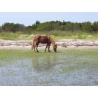
The museum is located at Shell Point on Harker's Island behind Barden's Inlet/Cape Lookout.

Core Sound Waterfowl Museum & Heritage Center
1785 Island Road
Harkers Island, NC 28531
(252) 728-1500

For some reason their website is down at the moment but here's the URL www.coresound.com
Here's the Museum's Facebook page.

https://www.facebook.com/pages/Core-...r/108800729612

The museum is staffed by island born and bred folks. There's a good chance that some of their grandparents (Heck-Maybe parents!) were born and raised in Diamond City.

You may also want to contact Scott Taylor. Scott is a well known photographer that lives in Beaufort. He worked for Duke Marine Lab as a photographer for almost 20 years before setting up his own studio about 15 years ago. Here's his URL http://www.scotttaylorphoto.com/

I just thought of another one. Katie Mosher with North Carolina Sea Grant. She's the Communications Director. I recall a publication NC Sea Grant put out about 15 years ago doing an aerial pictorial history of all NC inlets. Here's katie's contact info: http://www.ncseagrant.org/component/content/article/41

I know all of these folks. All are super nice and will help you in any way they can.

Last edited by Bill Hitchcock; 09-17-2011 at 03:25 PM..
Reply With Quote Quick reply to this message
 
Old 11-19-2013, 06:18 PM
 
1 posts, read 2,872 times
Reputation: 10
This last week I was a volunteer for the NPS staying in the Keepers Quarters next to the Cape Lookout Light. One of our visitors was telling his grand children that the rock jetty was originally started for a railroad bridge from the island to Morehead City to eventually develop the island. WWI started and ended the project. A ranger I spoke with confirmed a railroad was planned to connect the island with the mainland, but could not confirm what I had heard about the jetty.

In any respect, I am happy to say, the island is still as pristine today as it was then.
Reply With Quote Quick reply to this message
Please register to post and access all features of our very popular forum. It is free and quick. Over $68,000 in prizes has already been given out to active posters on our forum. Additional giveaways are planned.

Detailed information about all U.S. cities, counties, and zip codes on our site: City-data.com.


Reply
Please update this thread with any new information or opinions. This open thread is still read by thousands of people, so we encourage all additional points of view.

Quick Reply
Message:


Over $104,000 in prizes was already given out to active posters on our forum and additional giveaways are planned!

Go Back   City-Data Forum > U.S. Forums > North Carolina > Coastal North Carolina

All times are GMT -6.

© 2005-2024, Advameg, Inc. · Please obey Forum Rules · Terms of Use and Privacy Policy · Bug Bounty

City-Data.com - Contact Us - Archive 1, 2, 3, 4, 5, 6, 7, 8, 9, 10, 11, 12, 13, 14, 15, 16, 17, 18, 19, 20, 21, 22, 23, 24, 25, 26, 27, 28, 29, 30, 31, 32, 33, 34, 35, 36, 37 - Top