Please register to participate in our discussions with 2 million other members - it's free and quick! Some forums can only be seen by registered members. After you create your account, you'll be able to customize options and access all our 15,000 new posts/day with fewer ads.
I hope Leslie's going out to sea but it's still too early to tell. At one point they were saying Isaac would go out to sea too and we know what happened there.
Historical trends shows there is a good chance for US impact... I could see Outer Banks of NC, or Maine, Maritime Canada getting a good hit with this one, or it could just stay out to sea.
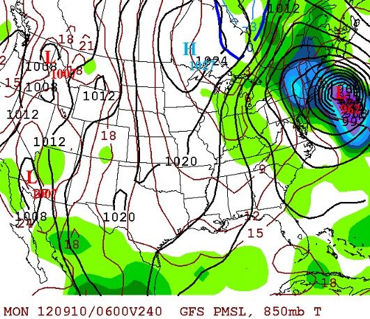
18z GFS...mother of god... 958mb!! Latest run shows it following a similar track to Igor 2010. Not affecting the US, but watch out Bermuda and Newfoundland.
Aside from some rough surf on the East coast, I am concerned about the island of Bermuda based on the latest Euro. Every model is now shifting west towards the U.S.
Quick Update: Leslie crawling for days now. The timing could be impecable with the swinging of the trough in the East. IF IF the trough moves out first, Leslie will move West towards U.S. OR if the trough goes Negative, Leslie will be caught and carried to East coast. (north of Mid Atlantic)
Here's the Euro12z. Minimum Pressure = 922mb right over Bermuda. Instant Weather Maps
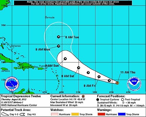
...leslie maintaining 60 mph winds...
...large swells expected to affect the u.s. East coast...
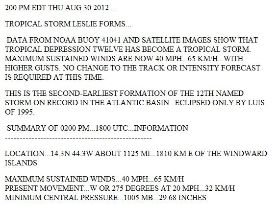
Summary of 1100 am ast...1500 utc...information
-----------------------------------------------
location...24.4n 63.1w
about 510 mi...825 km n of the leeward islands
about 555 mi...895 km s of bermuda
maximum sustained winds...60 mph...95 km/h
present movement...nnw or 330 degrees at 8 mph...13 km/h
minimum central pressure...998 mb...29.47 inches
maximum sustained winds remain near 60 mph...95 km/h...with higher
gusts. Little change in strength is forecast during the next couple
of days.
Tropical-storm-force winds extend outward up to 205 miles...335 km
from the center.
Please register to post and access all features of our very popular forum. It is free and quick. Over $68,000 in prizes has already been given out to active posters on our forum. Additional giveaways are planned.
Detailed information about all U.S. cities, counties, and zip codes on our site: City-data.com.

 Please register to participate in our discussions with 2 million other members - it's free and quick! Some forums can only be seen by registered members. After you create your account, you'll be able to customize options and access all our 15,000 new posts/day with fewer ads.