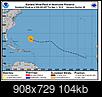
11Sept18 5aEDT - Winds 140mph, moving WNW 15mph, pressure 944mb. Holding at a Cat4 still currently.
Short version:
-Storm should stay level in intensity a few hours, then go up a little more.
-Hurricane and Surge Watches up.
-Good news: its possible but maybe not in time to help too much, that wind shear shows up at last minute and starts to weaken storm but powerful one expected still.
-Bad news: still uncertainty in landfall point.
-Good/Bad news: Storm may stall right at/near the coast. Good because that means strong winds would only go so far inland, bad because prolonged experience for those who do get it.
Long version:
Hurricane Watch for Edisto Beach, SC to NC/VA border (winds 74+mph possible within 48hours or less). This will change to a Warning once we're about 24hours from landfall and hopefully narrow down more as we get closer to event start. Hurricane force winds(74+mph) now reach up to 40miles from the storm center, Tropical Storm force winds (39+mph) up to 150miles.
When could winds start to arrive? Here are when 39mph or higher could start and this is your cut-off to be prepared, evacuated if going to do so, or at what ever location you'll be at for the duration of the storm if you need something to go by time frame wise:
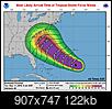
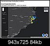
Storm Surge Watch for Edisto Beach, SC to NC/VA border including the Albemarle and Pamlico Sounds, Neuse and Pamlico Rivers.
Interactive Storm Surge map is out:
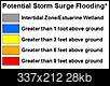
https://www.nhc.noaa.gov/refresh/gra...ation#contents This represents the plan for this, hope for less amount of surge from Florence. Surge is the rise in water above normal tide levels so if hits at high tide then worst case scenario if hits at low tide then not quite as high but near. Think of surge like a high high tide, its the entire body of water rising like a tide with waves on top and is always highest on the NE corner of the eyewall and less as you head away from that point.
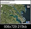
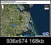
**These graphics assume storm comes in between Wilmington, NC and Morehead City NC** (again subject to shift left or right as usual):
And a selected few for closeups:

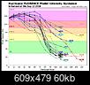
 Florence has leveled off for the time being (winds)
. Pressure and winds holding for at least a few hours. It's undergoing an ERC
(Eyewall replacement cycle), typical in Cat3 or larger storms. It's a few hour to day long process where the storm recharges it's batteries so to speak then goes back to trying to maintain itself or become stronger again. These are hard to predict when they will occur but radar and hurricane hunter aircraft flying directly into the storm taking readings can tell us if one is occurring. When an ERC occurs the winds either stay level or come down some even for those few hours.
Expected to restart it's strengthening process after the ERC (See above) is complete and NHC is calling for a border line Cat4/5 storm within 24-36 hours. But in 48 hours near landfall NHC says shear may come back into play and we could see Florence begin to weaken. Intensity guidance shows this too, but still expecting a powerful Cat4-ish storm into the coast somewhere at this time still.
The official cone map although has tightened until near the coast then still spreads considerably right at landfall. Hopefully more clarity on that today. There is still uncertainty on where it will come ashore. Please be careful watching the weather channel that continues to show a specific track and related graphics to that effect and just every now and then says it could move left or right. You also see this with the WPC NOAA group because they are providing rainfall estimates but that typically coincides with the GFS model which is more towards the right side of the 'cone' compared to the Euro which is more towards the left side of the cone. And we clearly see this with the surge maps above! Uncertainty remains unfortunately. Landfall location has NOT been called for by the NHC yet and anywhere in the cone is where the center/eye could go. I do fear that focusing on a specific graphics scenario now may result in large number of people deciding to stay instead of heed officials instructions.
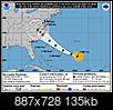
But I will say one of the main hurricane models and several members takes this into Morehead City NC which is probably why the surge graphics reflect that outcome at this time. Really hope the models come more in line today so we can yea or nay here. But we shall see. Wilmington NC and Morehead City NC have several models showing that way.

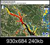
And here's the Euro 'ensembles' (the models that make up the Euro) once again about half it's members come into SC coast still:
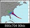
This also means the affects felt may move around until we know where it will go.
Euro rain map:
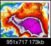
and GFS rain map:
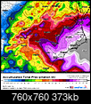
Guidance still at odds. Still what we can take from this is that heavy rains, very likely inland flooding as well, is coming. They agree on that at least. NHC says 15-20inches, isolated 30inches somewhere inland.

 Please register to participate in our discussions with 2 million other members - it's free and quick! Some forums can only be seen by registered members. After you create your account, you'll be able to customize options and access all our 15,000 new posts/day with fewer ads.


