9Sept18 2aPDT/5aEDT: Invest 92E became Tropical Depression 18E and now Tropical Storm Paul well off the W Mexico coast. Estimated winds 40mph(65km/h), moving NW 8mph(13km/h), pressure 1004mb.
Steady slow strengthening currently expected, but eventual weakening though by late this week.
Official updates for East Pacific basin storms comes from the US National Hurricane Center based in Miami, FL. Updates are issued at 2 & 8am/pmPDT(5 & 11am/pmEDT) (If Watches/Warnings issued then updates are also added at 5 & 11am/pmPDT (2 & 8am/pmEDT) here:
https://www.nhc.noaa.gov/?epac
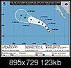
Cone map (Shows: Current storm wind field at storm center(orange: winds 39mph+, red: 74mph+), Classification (Black/white dots with letters: "D" = Depression, "S" = Tropical Storm, "H" = Cat1 or Cat2 Hurricane, "M" = Major Hurricane (Cat3+)), any coastal tropical Watches/Warnings, and the "cone" is where the center of the storm could be over time (it's NOT the size of the storm), effects of the storm can be felt outside this area:
Some Satellite imagery sources:
-Tropical Tidbits:
https://www.tropicaltidbits.com/sat/
-GOESeast(GOES16):
https://www.star.nesdis.noaa.gov/GOES/index.php
-WeatherNerds:
https://www.weathernerds.org/satellite/floaters/
 Please register to participate in our discussions with 2 million other members - it's free and quick! Some forums can only be seen by registered members. After you create your account, you'll be able to customize options and access all our 15,000 new posts/day with fewer ads.


