How mountain ranges were created...(for serious scientist only please)
Please register to participate in our discussions with 2 million other members - it's free and quick! Some forums can only be seen by registered members. After you create your account, you'll be able to customize options and access all our 15,000 new posts/day with fewer ads.
cjg5 brought up an interesting premise about the ice-age, a few posts back...and I was like 'duh'...I forgot about that...
They fed off of my observed sight science, when I mentioned or wondered why some mountains looked as if they had been 'carved up from the surface' rather than created from beneath...
Also, my constant observation of how many parts of the SW desert look like gigantic drain basins...the kind you see in your back yard or if you live in the mid west, like kansas or any other farmland in Nebraska, you notice how after the spring floods, the fields which the ice melts from, leaves behind simular drain basins, as you see in the desert, only on a much smaller scale...
So I did a bit of reseach...or as Trackwatch says 'homework'...and found this out...
Around 10,000 years ago...(let's not get hung up in dates to much ok, it's just a generic guess that I'm quoting from what I read)...
Anyways...around 10-12,000 years ago...Ice covered 1/3 of the land mass...
Ok...that's a lot of ice...lots of stored kenetic or potential energy stored, frozen...
This is very significant folks...
Cause what happened is for whatever reason, this ice began to melt...millions of mega tons of ice, water, melting and flowing...carving up the landscape as it recieded back into the ocean....
Also...because there was so much frozen water at the time...the average sea level was about 400ft lower than it is today (got that from a guest scientest on Coast to Coast last night)...
in other words, the oceans were more shallow...
Back to my point...
As the ice melted from these glacers, and as the glacers themselves moved and slid over the landscape...they basically carved the ground beneath them, as I originally observed or noted...
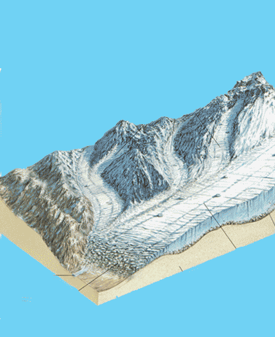
Again...if you drive through the SW desert, it basically looks like a giant drain basin...a gigantic dried up river bed in other words...
And in light of this new information about all that ice melting...and all this occuring less that 12,000 years ago...well...to put it plainly, I'm kind of joyious...cause it explains a lot...
I've always theorized that canyons were not formed over millions of years, but rather shaped and carved out in months, days, or years, by a massive recieding melt off of water...
If a small stream of water can push soil aside and carve mud, imagine what mega tons of gushing water, a flood to which the likes no man has seen, could do, did do, to anything in its path...expecially the limestone type soil of the SW...
But before I end this post...let's be clear...canyons are not the same as mountains...totally different in how they are formed...
But the connection here for me, is the speed at which they did form, and how fast acting forces of nature played an important role in that...
F= m x a....that is if you want significant change...
Which I read also explains why you find high mountain lakes....
And when water freazes between rocks, and expands, rocks break apart...
This is awesome, caus the glacier factor really does explain a lot of the 'carved' up look that mountains have...
Nobody denies the awesome power of water, flooding, and its ability to carve out landscapes fairly quickly.
You said you grew up in Eastern Washington. You should know all about Dry Falls and the coulees of Eastern Washington, created by a series of colossal floods by the draining of the ancient Lake Missoula as the ice dams holding it back broke, reformed, and broke again. These massive floods stripped a lot of top soil away from Eastern Washington, deposited boulders all the way down into the Willamette Valley of Oregon, helped to carve out the Columbia River Gorge and basin surrounding it, and sculpted out landscapes across the entire region. Very powerful forces of erosion at work. So yes, cataclysmic events such as this can take place quite quickly and suddenly under the right conditions.
However, did these forces actually CREATE the mountains? No, they most certainly did not. Again, that process happened slowly over a very long time.
BTW, boulders and rock were also deposited by glacial advances all over the world. As the glaciers moved, they scraped and carved the landscape, taking many loose soils and rocks with it. Again, this didn't build mountains, but it did help shape them. There is a difference.
cjg5 brought up an interesting premise about the ice-age, a few posts back...and I was like 'duh'...I forgot about that...
They fed off of my observed sight science, when I mentioned or wondered why some mountains looked as if they had been 'carved up from the surface' rather than created from beneath...
Also, my constant observation of how many parts of the SW desert look like gigantic drain basins...the kind you see in your back yard or if you live in the mid west, like kansas or any other farmland in Nebraska, you notice how after the spring floods, the fields which the ice melts from, leaves behind simular drain basins, as you see in the desert, only on a much smaller scale...
So I did a bit of reseach...or as Trackwatch says 'homework'...and found this out...
Around 10,000 years ago...(let's not get hung up in dates to much ok, it's just a generic guess that I'm quoting from what I read)...
Anyways...around 10-12,000 years ago...Ice covered 1/3 of the land mass...
Ok...that's a lot of ice...lots of stored kenetic or potential energy stored, frozen...
This is very significant folks...
Cause what happened is for whatever reason, this ice began to melt...millions of mega tons of ice, water, melting and flowing...carving up the landscape as it recieded back into the ocean....
Also...because there was so much frozen water at the time...the average sea level was about 400ft lower than it is today (got that from a guest scientest on Coast to Coast last night)...
in other words, the oceans were more shallow...
Back to my point...
As the ice melted from these glacers, and as the glacers themselves moved and slid over the landscape...they basically carved the ground beneath them, as I originally observed or noted...
Again...if you drive through the SW desert, it basically looks like a giant drain basin...a gigantic dried up river bed in other words...
And in light of this new information about all that ice melting...and all this occuring less that 12,000 years ago...well...to put it plainly, I'm kind of joyious...cause it explains a lot...
I've always theorized that canyons were not formed over millions of years, but rather shaped and carved out in months, days, or years, by a massive recieding melt off of water...
If a small stream of water can push soil aside and carve mud, imagine what mega tons of gushing water, a flood to which the likes no man has seen, could do, did do, to anything in its path...expecially the limestone type soil of the SW...
But before I end this post...let's be clear...canyons are not the same as mountains...totally different in how they are formed...
But the connection here for me, is the speed at which they did form, and how fast acting forces of nature played an important role in that...
F= m x a....that is if you want significant change...
Which I read also explains why you find high mountain lakes....
And when water freazes between rocks, and expands, rocks break apart...
This is awesome, caus the glacier factor really does explain a lot of the 'carved' up look that mountains have...
As I suggested in a former post...
Glaciers tend to melt on much longer time scales than would allow for "gushing" "mega tons" of water.
Additionally, aren't large portions of the southwest SANDSTONE not limestone? These means they are primarily silicates and not carbonates. The Karst formations of the SE are more typical of limestone. Many sandstones (like those found in the US SW) are much more resistant to weathering than limestone.
Taken together, the idea of glacier melting FLOOD waters carving things is less likely than the glaciers themselves generating geologic features. Especially since these "mega tons of gushing water" would obliterate the glacier till that can still be found in most of these areas.
The last ice age ended about 10,000 years ago but there were others throughout Earth's history. There are many sources of information regarding this.
A really basic program that explains Earth's geologic history is How the Earth was made.
If I can find them I will post personal pictures that show what glaciers did to the rock underneath, sometimes large rocks within the glacier were dropped when the glacier melted..
Last edited by Trackwatch; 12-29-2011 at 12:31 AM..
The last ice age ended about 10,000 years ago but there were others throughout Earth's history. There are many sources of information regarding this.
A really basic program that explains Earth's geologic history is How the Earth was made.
If I can find them I will post personal pictures that show what glaciers did to the rock underneath, sometimes large rocks within the glacier were dropped when the glacier melted..
How so ? Plate tectonics explain some mountains and glaciers explain some land formations.
Seriously? You didn't get that? Too subtle? I was being punny. I thought for sure you would have enjoyed that. Too bad that some of my best material gets lost on the audience.
I'll explain. You wrote,
Quote:
If I can find them I will post personal pictures that show what glaciers did to the rock underneath, sometimes large rocks within the glacier were dropped when the glacier melted..
Seriously? You didn't get that? Too subtle? I was being punny. I thought for sure you would have enjoyed that. Too bad that some of my best material gets lost on the audience.
I didn't get it either...until i hit that link...now I do...
erratic is the process of a rock the size of a bb to the size of a small Motor home (boulder), floating or being carried by recieding glacier...
And according to that explanation, is often times why you will see a giant boulder, just sitting in the middle of a forest or other spot where it logically should not be...cause it floated along or within the glacier until the ice melted enough for it to fall or sink to the bottom...and land wherever...
I can buy that....either that or a giant cyclops was having a boulder throwing contest...
Please register to post and access all features of our very popular forum. It is free and quick. Over $68,000 in prizes has already been given out to active posters on our forum. Additional giveaways are planned.
Detailed information about all U.S. cities, counties, and zip codes on our site: City-data.com.

 Please register to participate in our discussions with 2 million other members - it's free and quick! Some forums can only be seen by registered members. After you create your account, you'll be able to customize options and access all our 15,000 new posts/day with fewer ads.


 You didn't get that? Too subtle? I was being punny. I thought for sure you would have enjoyed that. Too bad that some of my best material gets lost on the audience.
