Please register to participate in our discussions with 2 million other members - it's free and quick! Some forums can only be seen by registered members. After you create your account, you'll be able to customize options and access all our 15,000 new posts/day with fewer ads.
All right, hopefully someone who has actually taken the 10 mile hike or just plain knows about it will help me out. Every year, I mean for about 8 years I go on to the Reserve and cannot find the 10 mile trail to the Colorado border. I've hung rights and left from the entrance and get nothing. I really want to hike it this September. I've tried to get a map without luck. When I paid to do the walk they (at the grocery store there in Chama) have no idea of where the hike is only I have to pay 5 dollars to do it. I went to Vistors Center with no luck and the Park Rangers on the phone just say it is marked. The only thing marked is a 100 foot walk to a bench under a tree talking about a lady who was a park ranger who died.
Never been there, but http://www.wildlife.state.nm.us/publ..._humphries.pdf says "At the Sargent, visitors may follow the level dirt road (on foot, horseback, or mountain bike) 10 miles to the Colorado border or turn right, 3.5 miles from the site entrance, onto a faint dirt track which leads to Nabor Lake, a small reservoir pond."
I have all that information too. Even called them last year. I guess I'll just do more exploring out there. I really wanted to do the 10 mile loop though. You'd have to be on the reserve to understand what I am saying. The local outfitters are great if you want to go horsebacking through some of the most beautiful country on earth. We spend a few weeks a year in that area alone.
Last edited by debbie at bouontiful; 03-25-2013 at 06:42 AM..
Still wondering if any of you Chama or New Mexico/Colorado people every hiked Edward Sargent wildlife. Can't figure out the traile and believe me there is mo map showing trails that I've come across. Gone to the visitor center there in Chama a few times and they don't seem to even know about the reserve. I get my pass every year to go on it but haven't had success if their is a trail or not. I am guessing not! I'll be up there in less than two weeks.
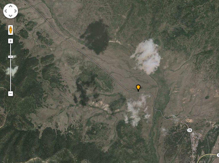
This map has the info/trail marked. Zoom in and out, move the map, turn map/satelite on and off. The map has the trail marked (There are some forks in the trail):
I am going to do the walk this year. Lets hope I do not get lost. I can walk a good 6 plus miles before I feel it but if I take the wrong turn. Maybe I should buy a compass and take water with me of course. Just kidding but last year I walked for a long time and there was no noticeable trail. Did see evidence of horses so I can't help but think there must bes a decent riding trail to follow. I certainly would never take my trail horses to a place that I couldn't find the trail for them.
I'd think about buying a hiking GPS, learn to use it and mark trail points as you go along. Pretty helpful in retracing your steps if you do get lost. Nobody ever thinks they will but it pays to be prepared.
Also, don't go where you wouldn't go without GPS thinking technology can bail you out of a bad situation. Too many folks these days end up going places they shouldn't cuz they rely too much on their GPS or cell phone.
Please register to post and access all features of our very popular forum. It is free and quick. Over $68,000 in prizes has already been given out to active posters on our forum. Additional giveaways are planned.
Detailed information about all U.S. cities, counties, and zip codes on our site: City-data.com.

 Please register to participate in our discussions with 2 million other members - it's free and quick! Some forums can only be seen by registered members. After you create your account, you'll be able to customize options and access all our 15,000 new posts/day with fewer ads.