Welcome to City-Data.com Forum!
U.S. CitiesCity-Data Forum Index
Go Back   City-Data Forum > General Forums > Politics and Other Controversies
 [Register]
Please register to participate in our discussions with 2 million other members - it's free and quick! Some forums can only be seen by registered members. After you create your account, you'll be able to customize options and access all our 15,000 new posts/day with fewer ads.
View detailed profile (Advanced) or search
site with Google Custom Search

Search Forums  (Advanced)
Reply Start New Thread
 
Old 06-24-2012, 11:58 PM
 
Location: Sarasota FL
6,864 posts, read 12,080,222 times
Reputation: 6744

Advertisements

The planet is 3.4 billion years old and has gone through hundreds of heating and cooling periods, some lasting thousands of years. Sea shells can be found hundreds of miles inland from oceans. The writer of the Yahoo news article states that 'the melting Greenland ice sheets' are causing the rising of the sea level on the east coast of the U.S. Greenland is called Greenland because, guess what, it use to be green farm land. If the ice is melting, it's just part of the thousands of years of cycles and the east coast will be a couple of feet under water as it was thousands of years ago. Sea fossils can be found hundreds of feet above the Hudson River in the NJ Palisades. 11,000 years ago, NYC, NY Harbor was under a mile thick ice and Florida was twice the width as it is now.
To blame any conditions to humans driving vehicles of the last hundred years causing climate change and make ice melt in Greenland is just a ridiculous assertion. It's just another scheme to get more money out of the pockets of the producers to 'spread the wealth' and keep research professors employed.
Reply With Quote Quick reply to this message

 
Old 06-25-2012, 01:03 AM
 
8,091 posts, read 5,912,262 times
Reputation: 1578
Quote:
Originally Posted by sickofnyc View Post
...and humankind has had no impact on it whatsoever.
Are you old enough to remember the Radon fear mongering???

What happened to it??? It just went away??? That was backed by a whole lot of pseudo-science as well.
Reply With Quote Quick reply to this message
 
Old 06-25-2012, 01:04 AM
 
8,091 posts, read 5,912,262 times
Reputation: 1578
Report update: we will die
Reply With Quote Quick reply to this message
 
Old 06-25-2012, 09:46 AM
 
15,912 posts, read 20,201,643 times
Reputation: 7693
Antarctic ice shelves not melting at all, new field data show

Quote:
Twenty-year-old models which have suggested serious ice loss in the eastern Antarctic have been compared with reality for the first time - and found to be wrong, so much so that it now appears that no ice is being lost at all.
Antarctic ice shelves not melting at all, new field data show
Reply With Quote Quick reply to this message
 
Old 06-25-2012, 09:57 AM
 
41,813 posts, read 51,059,937 times
Reputation: 17865
Quote:
Originally Posted by BentBow View Post
When the ice melts in the full glass of water, does the glass overflow?
While it's true the sea level would actually go down if it were only floating ice that's not the case, most of the ice is on land.
Reply With Quote Quick reply to this message
 
Old 06-25-2012, 10:36 AM
 
Location: Victoria, BC.
33,548 posts, read 37,145,710 times
Reputation: 14001
Quote:
Originally Posted by plwhit View Post
Antarctic ice shelves not melting at all, new field data show


Antarctic ice shelves not melting at all, new field data show
What is the A Register? They certainly misinterpreted the data... Here is the paper they reported on...It does NOT say that there is no melting, but describes the causes of melting.

Oceanic heat for basal melting is found to be sup-plied by two sources of warm water that enter below the ice: (i) eddy-like bursts of Modified Warm Deep Water accesses the cavity at depth during eight months of the record; and (ii) a seasonal inflow of warm, fresh surface water flushes parts of the ice base with temperatures above freezing, during late summer and fall. This interplay of processes implies that basal melting cannot simply be parameterized by coastal deep ocean temperatures, but is directly linked to both solar forcing at the surface as well as to coastal processes controlling deep ocean heat fluxes. Two years of oceanic observations below the Fimbul Ice Shelf, Antarctica
Reply With Quote Quick reply to this message
 
Old 06-25-2012, 10:43 AM
 
4,255 posts, read 3,480,513 times
Reputation: 992
So all the rich folks with waterfront props have to rebuild. That will be an economic stimulous. Can we speed this up?
Reply With Quote Quick reply to this message
 
Old 06-25-2012, 11:01 AM
 
14,022 posts, read 15,028,594 times
Reputation: 10471
The Lowest settlement in Boston is like 10 feet Above sea level, so oh my god, in 1000 years, we could face some problems.
Also Boston is extremly hard to get a surge into because the opening to the outer Harbor is the North East, and inner harbor is to the Southwest.
Reply With Quote Quick reply to this message
 
Old 06-25-2012, 11:32 AM
 
Location: Long Island
32,816 posts, read 19,488,320 times
Reputation: 9618
wow(according to that 'news' opinion) in a century (100 years) it will go up a total of 8 inches

the sea level is the same as it was 150 years ago

the sealevel is nearly the same as it was in 1842
...infact it is BELOW the sealevel mark made in 1842

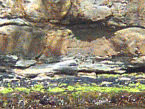
In 1842 the "Isle of the Dead" in SE Tasmania was selected for the site of a "Mean Sea Level" refernce mark by Capt. James Clark Ross. Today this mark can clearly be seen 35 cm ABOVE the current mean sea level.

For a wonderful examination of Sea Level change from 1841 to 2004, this picture is worth a thousand words:


Here is another view — this time, the mark has been traced over with line to emphasize it


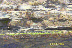
The 1841 sea level benchmark (centre) on the ‘Isle of the Dead’, Tasmania. According to Antarctic explorer, Capt. Sir James Clark Ross, it marked mean sea level in 1841. Photo taken at low tide 20 Jan 2004. Mark is 50 cm across; tidal range is less than a metre.
Let’s read that again and consider four things:

#1) - the mark was placed at mean sea level. The word “mean” in this use denotes the “mathematical average”. The sea rose above it and set below it by an equal amount during the tidal cycle.
#2) - The mark was made in the middle of the tidal range in 1841 and it was photographed 163 years later at the bottom of the tidal cycle.
#3) - the tidal cycle is one meter and the mark is 50 centimeters or one-half meter long.
#4) - the mark is sitting about 30 or 40 centimeters above the water in the photograph. Given that there is some wave surge, it looks like the level of the ocean has not changed one bit in 163 years.


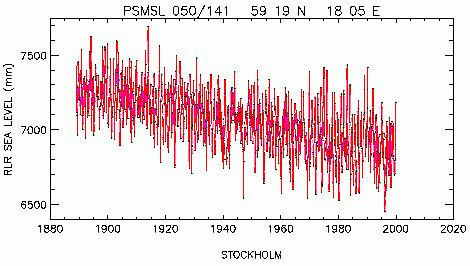
and here sealevels monitored in Stockholm


and lets not forget that sealevel rate changes all the time


oh and lets not forget that the 'land' is on MOVING TECTONIC plates.....and Mean sea level is not constant over the surface of the Earth. For instance, mean sea level at the Pacific end of the Panama Canal stands 20 cm (7.9 in) higher than at the Atlantic end.


Over most of geologic time, long-term sea level has been higher than today (see graph above). Only at the Permian-Triassic boundary ~250 million years ago was long-term sea level lower than today. Long term changes in sea level are the result of changes in the oceanic crust, with a downward trend expected to continue in the very long term.

During the glacial/interglacial cycles over the past few million years, sea level has varied by somewhat more than a hundred metres. This is primarily due to the growth and decay of ice sheets (mostly in the northern hemisphere) with water evaporated from the sea.

The Mediterranean Basin's gradual growth as the Neotethys basin, begun in the Jurassic, did not suddenly affect ocean levels. While the Mediterranean was forming during the past 100 million years, the average ocean level was generally 200 metres above current levels. However, the largest known example of marine flooding was when the Atlantic breached the Strait of Gibraltar at the end of the Messinian Salinity Crisis about 5.2 million years ago. This restored Mediterranean sea levels at the sudden end of the period when that basin had dried up, apparently due to geologic forces in the area of the Strait.
Reply With Quote Quick reply to this message
 
Old 06-25-2012, 12:47 PM
 
16,545 posts, read 13,455,215 times
Reputation: 4243
Someone needs to seriously explain how only a certain portion of the US coast is affected?!?!?! Water seeks it's own level, it doesn't rise in one area and not in adjacent areas. It either ALL rises or doesn't. What is being described sounds more like simple erosion of the coast line, not rising waters.
Reply With Quote Quick reply to this message
Please register to post and access all features of our very popular forum. It is free and quick. Over $68,000 in prizes has already been given out to active posters on our forum. Additional giveaways are planned.

Detailed information about all U.S. cities, counties, and zip codes on our site: City-data.com.


Reply
Please update this thread with any new information or opinions. This open thread is still read by thousands of people, so we encourage all additional points of view.

Quick Reply
Message:


Over $104,000 in prizes was already given out to active posters on our forum and additional giveaways are planned!

Go Back   City-Data Forum > General Forums > Politics and Other Controversies
Similar Threads

All times are GMT -6. The time now is 10:29 PM.

© 2005-2024, Advameg, Inc. · Please obey Forum Rules · Terms of Use and Privacy Policy · Bug Bounty

City-Data.com - Contact Us - Archive 1, 2, 3, 4, 5, 6, 7, 8, 9, 10, 11, 12, 13, 14, 15, 16, 17, 18, 19, 20, 21, 22, 23, 24, 25, 26, 27, 28, 29, 30, 31, 32, 33, 34, 35, 36, 37 - Top