Updated Triangle Municipal Limits Map??? (Raleigh, Durham: chapel, house, moving)
Raleigh, Durham, Chapel Hill, CaryThe Triangle Area
Please register to participate in our discussions with 2 million other members - it's free and quick! Some forums can only be seen by registered members. After you create your account, you'll be able to customize options and access all our 15,000 new posts/day with fewer ads.
Has anyone seen an updated online municipal map for the entire Triangle? I'm looking for one that clearly outlines and identifies all of the municipalities.
I'm looking for something like this but for the entire Triangle area. http://www.wakegov.com/inspect/Publi...dictionmap.jpg
Thanks!
For what purpose do you want to use the map? Just to get a feel for where city limits are? Or are you trying to drill down and see in which municipality an individual house is located?
Bumping this back up to the top. Other than the scan of the road map, does anyone know if an updated one exists. I'm interested in seeing how the municipalities are filling in the spaces between them. Probably the most interesting story to be visually told is how Cary and Apex are moving westward and what that means to their proximity to southern Durham.
if you go on Google Maps and type in the city, you can see the municipal boundaries. You can't do a side by side comparison of 2 municipalities though so you'll sort of have to remember what you saw before.
I'm surprised the Research Triangle Partnership doesn't have one on their website, but I can't find it there. You might want to call them and see if they have a paper one:
Jennifer Bosser
Executive Director, Research Triangle Cleantech Cluster
919-840-7372 ext. 9 jbosser@researchtriangle.org
Primary cities and towns
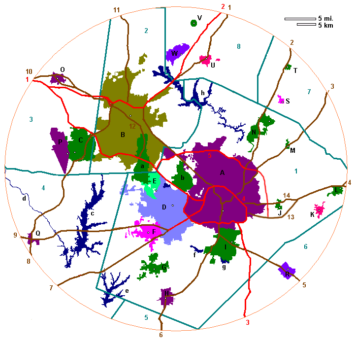
A - Raleigh
B - Durham
C - Chapel Hill
D - Cary
E - Morrisville
F - Apex
G - Holly Springs
H - Fuquay-Varina
I - Garner
J - Knightdale
K - Wendell
L - Zebulon
M - Rolesville
N - Wake Forest
O - Hillsborough
P - Carrboro
Q - Pittsboro
R - Clayton
S - Youngsville
T - Franklinton
U - Creedmoor
V - Stem
W - Butner
Counties
1 - Wake County
2 - Durham County
3 - Orange County
4 - Chatham County
5 - Harnett County
6 - Johnston County
7 - Franklin County
8 - Granville County
Parks and bodies of water
a - Research Triangle Park
b - Umstead State Park
c - Jordan Lake
d - Haw River
e - Harris Lake
f - Lake Wheeler
g - Lake Benson
h - Falls Lake
Other major highways
1 - US 15
2 - US 1
3 - US 401
4 - US 64
5 - US 70
6 - US 401
7 - US 1
8 - US 15-501
9 - US 64
10 - US 70
11 - US 501
12 - NC 147
13 - US 64-264
14 - US 64 Business
Please register to post and access all features of our very popular forum. It is free and quick. Over $68,000 in prizes has already been given out to active posters on our forum. Additional giveaways are planned.
Detailed information about all U.S. cities, counties, and zip codes on our site: City-data.com.

 Please register to participate in our discussions with 2 million other members - it's free and quick! Some forums can only be seen by registered members. After you create your account, you'll be able to customize options and access all our 15,000 new posts/day with fewer ads.