Please register to participate in our discussions with 2 million other members - it's free and quick! Some forums can only be seen by registered members. After you create your account, you'll be able to customize options and access all our 15,000 new posts/day with fewer ads.
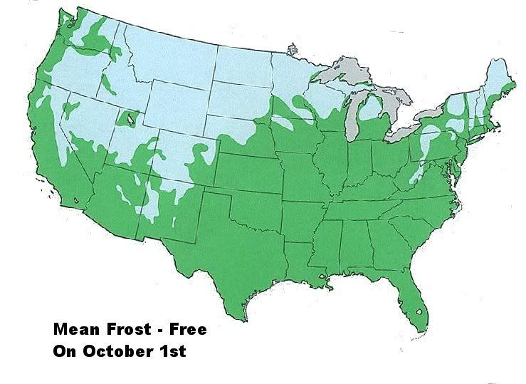
Now that we are officially in the fall season…I thought weather watchers would like to graphically see how the FROST-LINE invades the United States and moves southward. October is the month when many regions of the USA start to experience their first frost. These maps only represent a mean geographical line over a long time …your particular location might be several miles north/south of these lines in some years.
As you can see by the map...by October 1st, about 65-70% of the USA still has yet to experience a frost. Only the central/northern Western Mountain States…the Upper Midwest…parts of the Northern Great Lakes… and the higher elevations of the northern Northeast/New England… have experienced a frost so far.
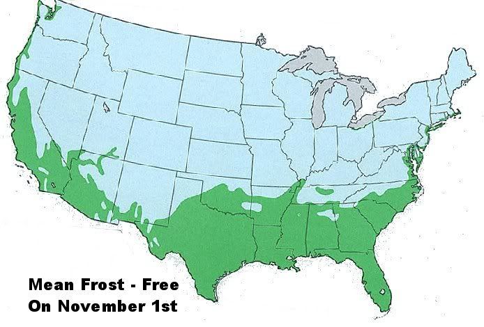
Now here is the map on November 1st...
By November 1st …the frost line has worked it’s way southward a great deal. The areas of the USA mainland that have not experience a frost yet are shaped like a deep “U” by the first days of November. Folks along the coast seem to make out the best: Only the coastal margins of the Pacific Coast, the extreme southwest, the subtropical southeast/Gulf States, and the immediate Atlantic Coast from Delaware through coastal Rhode Island/Cape Cod are still frost -free. It can be shocking to see the effect of the warmer oceans graphically on the frost-free map: Places like Seattle, Washington (49 N) are still frost-free…while places like Albuquerque, New Mexico (34 N) that are 1100 miles south have already experienced a frost…in the eastern USA a place like Cape May, New Jersey or Newport, Rhode Island (40 N) is still frost free… while Amarillo, Texas or Tulsa, Oklahoma (35 N) have already had a frost.
So, find your location and watch the blue army advance toward you. Some of us are closer to the “war front’ than others (lol). I guess we can only sit back now and wait.
Foks on the coasts have it best ... until April when most people in the "heartland" are enjoying high 60's and 70's with blooming flowers and trees getting green, while people near the coasts are suffering through cold winds off the water and temperatures in the 40's and 50s.
Foks on the coasts have it best ... until April when most people in the "heartland" are enjoying high 60's and 70's with blooming flowers and trees getting green, while people near the coasts are suffering through cold winds off the water and temperatures in the 40's and 50s.
Lol, only the southern portion of the "heartland" normally have highs in the 60's and 70's in April.
Lol, only the southern portion of the "heartland" normally have highs in the 60's and 70's in April.
Avg high is 65F in Cincinnati and 66F in St. Louis which is warmer than 61F in NYC. Not a huge difference, I guess, but it is definitely felt when winds blow from the east.
Avg high is 65F in Cincinnati and 66F in St. Louis which is warmer than 61F in NYC. Not a huge difference, I guess, but it is definitely felt when winds blow from the east.
I suppose you are right, seasonal delay is prevalent even down here in South FL...believe it or not.
Frost is not a given. Maybe we have 1-3 a year and then we could even get a hard freeze in November or in March. Snowbirds migrate here for a reason.
Please register to post and access all features of our very popular forum. It is free and quick. Over $68,000 in prizes has already been given out to active posters on our forum. Additional giveaways are planned.
Detailed information about all U.S. cities, counties, and zip codes on our site: City-data.com.

 Please register to participate in our discussions with 2 million other members - it's free and quick! Some forums can only be seen by registered members. After you create your account, you'll be able to customize options and access all our 15,000 new posts/day with fewer ads.


 .
.
