Please register to participate in our discussions with 2 million other members - it's free and quick! Some forums can only be seen by registered members. After you create your account, you'll be able to customize options and access all our 15,000 new posts/day with fewer ads.
San Fran and San Jose are always split apart according to official stats, they are only combined in CSA.
San Francisco and San Jose are 50 mi (80 km) apart, it's quite a distance, further apart than Washington, DC and Baltimore which are only 38 mi (61 km) apart.
Both San Fran and San Jose are included in the metropolitan bay area. There is no break in the urban footprint hence why it is known as a metroplex. Distance is irrelevant because the urban footprint is continuous.
Both San Fran and San Jose are included in the metropolitan bay area. There is no break in the urban footprint hence why it is known as a metroplex. Distance is irrelevant because the urban footprint is continuous.
We're seeing the pitfalls of the metro terminology because everyone has a different definition. As far as the Bay Area is concerned, yes SJ is generally included when speaking of the San Francisco Bay Area. On the west side, it's a continuous urban footprint right up through San Francisco where it ends abruptly by the Golden Gate. On the east side, it continues unbroken right up through Rodeo. This is where it gets tricky. How built up must an area be for it to be considered part of an urban footprint?
Then there's Santa Cruz. It is sometimes considered part of the Bay Area even though to get to it, you must drive through mountains filled with very thick forest. It is largely isolated from the urban footprint of the Bay Area. With Rio Del Mar, Capitola etc. it is more connected to Monterey with which it is also considered part of in metro area.
We're seeing the pitfalls of the metro terminology because everyone has a different definition. As far as the Bay Area is concerned, yes SJ is generally included when speaking of the San Francisco Bay Area. On the west side, it's a continuous urban footprint right up through San Francisco where it ends abruptly by the Golden Gate. On the east side, it continues unbroken right up through Rodeo. This is where it gets tricky. How built up must an area be for it to be considered part of an urban footprint?
Well exactly, this is why Richmond/Rodeo is included in the urban agglomeration. As for "how built up does an area need to be?" It's not that difficult to answer, basically where one constructed plot of land meets another constructed plot of land, whereby that land is not big enough to support Farmland, woodland or reserve. Hence the meaning of the term rural.
I purposefully chose the bay area because its the most tricky to explain but the idea of urban agglomeration is far easier in most cities and metroplexs like Dallas-Fort Worth.
Quote:
Originally Posted by Gentoo
Then there's Santa Cruz. It is sometimes considered part of the Bay Area even though to get to it, you must drive through mountains filled with very thick forest. It is largely isolated from the urban footprint of the Bay Area. With Rio Del Mar, Capitola etc. it is more connected to Monterey with which it is also considered part of in metro area.
Santa Cruz is only included in the 12 county CSA not the original 9 county Met area. Hence why I stress the point of urban agglomeration being the most accurate depiction. A place may be included in the Met area i.e. Windsor near London, but if it's not part of the continuous urban footprint then its not part of the urban agglomeration. It's a fact that surpasses Met area, CSA area, county/political lines, etc. which can often skew results.
Well exactly, this is why Richmond/Rodeo is included in the urban agglomeration. As for "how built up does an area need to be?" It's not that difficult to answer, basically where one constructed plot of land meets another constructed plot of land, whereby that land is not big enough to support Farmland, woodland or reserve. Hence the meaning of the term rural.
I purposefully chose the bay area because its the most tricky to explain but the idea of urban agglomeration is far easier in most cities and metroplexs like Dallas-Fort Worth.
Santa Cruz is only included in the 12 county CSA not the original 9 county Met area. Hence why I stress the point of urban agglomeration being the most accurate depiction. A place may be included in the Met area i.e. Windsor near London, but if it's not part of the continuous urban footprint then its not part of the urban agglomeration. It's a fact that surpasses Met area, CSA area, county/political lines, etc. which can often skew results.
Your last paragraph isn't entirely accurate. SC is frequently considered simply part of the Bay Area with the addition of San Benito County. Not sure where you got the 12th county from. Technically, it would be Central Coast but it tends to associate itself with the Bay Area and vice versa sometimes.
As far as how you defined continuous urban footprint, there was a post earlier that mentioned that Antioch wouldn't be included. Well, maybe/maybe not.
As you can see all 9 counties border "the bay", Santa Cruz and the other 2 do not. Antioch-Brentwood form their own urban agglomeration as do Concord-Walnut Creek separate from the San Fran-San Jose urban agglomeration. Whether o whether not they're part of the Bay Met area is by-the-by when you focus on urban agglomeration.
As you can see all 9 counties border "the bay", Santa Cruz and the other 2 do not. Antioch-Brentwood form their own urban agglomeration as do Concord-Walnut Creek separate from the San Fran-San Jose urban agglomeration. Whether o whether not they're part of the Bay Met area is by-the-by when you focus on urban agglomeration.
Being a Bay Area native, the Bay always includes the nine counties. Now the addition of San Joaquin County is one I forgot. That's a recent addition.
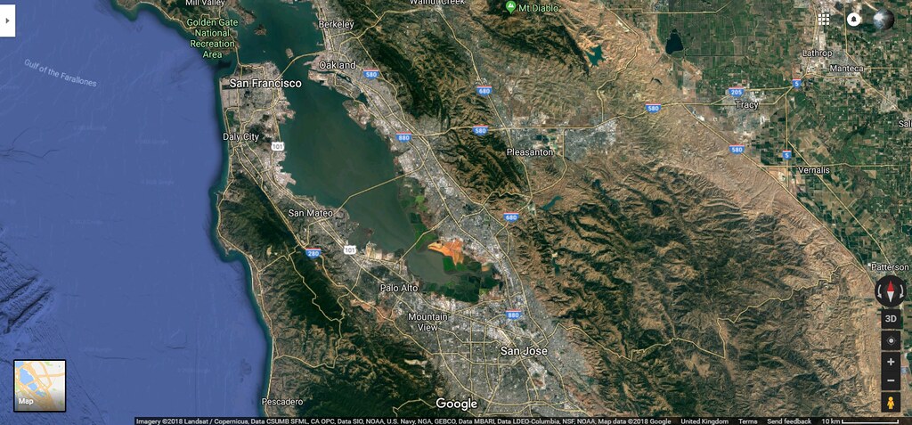
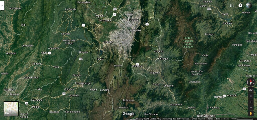
Interesting fact. Both these urban agglomerations have about the same population yet look at the difference in density. Both satellite images are taken at a distance of 10km (6.2 miles) from the Earth's surface, you can't even fit all of the Bay Area urban footprint on the image.
Yeaha, it's like comparing apples with strawberries.
Montréal is larger than Boston in reality! Don't get tricked by the US numbers, they are SOOO HIGH that people think "well, maybe this city is not sooo big but still very, very big?!".
Boston metropolitan area: 4,5 mill. Inhabitants on12105km², density: 371 people per km².
(Now Boston metro area seems to have 4,7 mill., which would mean a density of 388 per km²)
Metropolitan Montréal: 4,1 million inhabitants on 4,600km², density: 890 people per km².
Boston's metro area is 160% larger, contains towns that are more than 60km away from the core city, but has only 14,6% more residents than Montréal's metro.
If we exclude all these vast outlying lands and far-away-lying towns that Boston's metro area incorporates, Montréal's metro areas has more inhabitants than Boston's metro area.
Doing so, Montréal's metro area would shrink from 4,1 to 3,8-3,9 million inh., but Boston's metro area would shrink from 4,7 million inhabitants to only 3,3-3,6 million inhabitants.
According to Grega, Boston's urban area population is by US-American definiton:
Boston: 4,181,019 inhabitants on 4,852.2 km2, density: 861.7 people per km².
This urban area definition for Boston, nevertheless, still includes many stretches of land area, places with low-density and towns with no urban continuum to the core city. In fact, even the urban area defintion of the United States is still oversized, just less extreme.
If we want to compare Boston's urban population with Montréal, we also have to compare it to Montréal's urban area, which is:
3,5 million inhabitants on 1,294 km² with a density of 2,719 people per km².
This definition excludes anything rural or not-urban and places with low densities: Census Profile, 2016 Census - Montréal [Population centre], Quebec and Ontario [Province]
The real urban area for Boston by European and Canadian measurements is below 3 million inhabitants, and therefore smaller than Montreal, whose real urban area is 3,5 million inhabitants.
Plateau Mont Royal: 104 000 inhabitants on 8,1km² with a density of 12840 people per km².
Côte-des-Neiges–Notre-Dame-de-Grâce: 165 000 inhabitants on 21,4km² with a density of 7700km².
Ville Marie: 84 000 inhabitants on 14,5km² with a density of 5,800 people per km².
Outremont: 24 000 inhabitants on 3,9km", density 6100km².
Westmount: 20 000 inh. on 4km², density: 5000 km².
Rosemont-La Petite-Patrie: 134 000 inhabitants on 15,9km² with a density of 8,400km².
397 000 51,9 7649
The core of Île de Montréal: 531 000 inhabitants on 67,8km² with a density of 7830 people per km².
City of Boston: 687000 inhabitans on 232km² of which is 125,4km² land area. Density for land area: 5480 people per km².
Montréal is the second-largest city and second-largest real metro area after New York in the Québec, New York and New England "superregion". Boston is "only" number three and only larger by artifically bolstering its metro numbers.
You are also right, that comparing US metro regions with each other and from other countries does not make much sense. The metro regions who incorporated the largest land areas are simply more likely going to win and distort comparisons. Montréal probably is not in the lower-tier of the 25 largest metro areas in North America, it is probably in the upper-tier. It was the first Canadian city to reach more than 1,000,000 inhabitants and had Canada's largest urban area until the 1970s. It has a real dense core with an urban continuum, which is a mix of the typical super dense French big city and the less dense typical American city. It is bigger than Boston, Seattle, etc. and likely also Miami.
Yes! Good observation. American metro's are up to 8x larger than the actual primary city itself. In Russia, the metro areas usually are not more than 1,5x larger than the primary city itself, despite being also a large country.
I think your missing the point. Montréal is a dense city. Boston is not a dense city so it’s actual population is 4.1 million. Of course it includes low density areas because U.S cities have low density areas and Canadian cities don’t. Because of things like White Flight and general suburbanization which was extreme in the U.S more than any other country besides Australia. U.S has the least dense cities. Low density is a staple of the U.S city.
Basically, it has to do with the fact that people in the United States often drive so far for work.
I know people who live in south-central Pennsylvania who work in the DC area. It's quite a commute.
Great point. I think a lot of U.S cities grew in population quite substantially after WWII and a lot of that growth was accommodated in the fringes of the core city. Highways were really well developed in The U.S post WWII during the Eisenhower administration so I think that may have contributed to it.
Please register to post and access all features of our very popular forum. It is free and quick. Over $68,000 in prizes has already been given out to active posters on our forum. Additional giveaways are planned.
Detailed information about all U.S. cities, counties, and zip codes on our site: City-data.com.

 Please register to participate in our discussions with 2 million other members - it's free and quick! Some forums can only be seen by registered members. After you create your account, you'll be able to customize options and access all our 15,000 new posts/day with fewer ads.