Please register to participate in our discussions with 2 million other members - it's free and quick! Some forums can only be seen by registered members. After you create your account, you'll be able to customize options and access all our 15,000 new posts/day with fewer ads.
In your honest opinion, how would you rank the neighborhoods in terms of if you would live there or not? Which neighborhoods are fine, OK or are neighborhoods one should avoid?
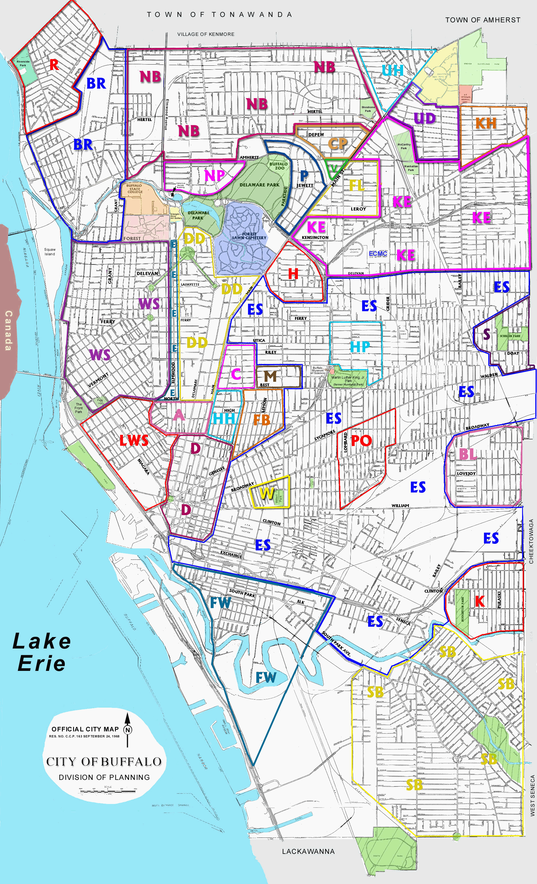
Really nice map! Very detailed and informative. The only things I would disagree with or want to change is to make Richmond Avenue the border between the West Side and the Elmwood Strip rather than Elmwood Avenue itself and perhaps make Elmwood Avenue the border between North Buffalo and Black Rock. When looking at Google Maps, streets such as Norwood Avenue, Ashland Avenue, and even Richmond Avenue itself look too pleasant and beautiful to fit in the West Side, which does look rundown in many parts.
Really nice map! Very detailed and informative. The only things I would disagree with or want to change is to make Richmond Avenue the border between the West Side and the Elmwood Strip rather than Elmwood Avenue itself and perhaps make Elmwood Avenue the border between North Buffalo and Black Rock. When looking at Google Maps, streets such as Norwood Avenue, Ashland Avenue, and even Richmond Avenue itself look too pleasant and beautiful to fit in the West Side, which does look rundown in many parts.
I have seen this map before and I think it's helpful, but its definitions are dated in many places. As you say, it doesn't even recognize "Elmwood Village," which is today the most recognizable "neighborhood" in this city (it includes parts of this map's "West Side" and "Delaware District"). Also, areas like North Buffalo, Downtown, and the East Side aren't neighborhoods in the same sense that, say, Allentown is (in fact, most people consider the neighborhood of Allentown to be a part of "downtown").
A lot of these neighborhood names are out of date. Today, "Humboldt Park" could only refer to the feeder road along the 33. This area should be called MLK Park. Also, I prefer "Broadway-Fillmore" to "Polonia." It's really only a Polish neighborhood once a year. And although the name "Midtown" is a blatant attempt to encourage gentrification, you hear it a whole lot more often than "Cold Springs" in reference to that area between Best and Utica along Main.
And where's "Grant/Ferry," or "Kleinhans"? Those are at least as legitimate as "Willert Park" as far as neighborhoods go. Looking at the recent BuffaloRising brand name neighborhoods, I'd also throw in the "Cobblestone District" and the "Near East Side" (which refers to the area of new builds just east of downtown).
Great map too bad no one can answer the OP's question. Rank the neighborhoods for livability~
Maybe its too difficult .
Can anyone distinguish between Riverside - Black Rock and West Side - these are the three neighborhoods bordering the Niagara River. Are they all the same? Blackrock seems to have a bad rep but what about the ones immediately north and south.
What about the neighborhood called WILERT PARK?
I really would like seeing someone who KNOWS Buffalo do the ranking.
Last edited by ocean2026; 02-06-2009 at 07:28 PM..
Great map too bad no one can answer the OP's question. Rank the neighborhoods for livability~
Maybe its too difficult .
I don't see how it could be difficult to crap out an opinion on whether I'd live in a given neighborhood. I just don't find it a very interesting question. For example, what's the point in saying, "Oh God, I'd never even set foot in Kensington"? This kind of thing is known as cyber slumming.
Quote:
Can anyone distinguish between Riverside - Black Rock and West Side - these are the three neighborhoods bordering the Niagara River. Are they all the same? Blackrock seems to have a bad rep but what about the ones immediately north and south.
They are very distinguishable by who lives there, vernacular architecture, geography, neighborhood amenities. I suggest you go walk the main commercial drags in each area, Grant St for the West Side, Amherst St for Black Rock and Tonawanda St (T-Street) for Riverside, to get a feel for the difference. They remain distinct areas.
Because of the 190, none of these areas really have access to the waterfront. However, if you're in the West Side on Ferry St, or in Black Rock by the Railroad bridge, you can get out onto Squaw Island, which is pretty nice.
And actually, the West Side is the one with the bad rep, although Black Rock is getting there. The West Side was largely Italian, and was devastated a long time ago by white flight. Now it's probably the most diverse area of the city with a lot of recent immigrants. Black Rock was historically a self-contained industrial area and remains isolated from the rest of the city today, due to barriers like the Scajaquada Expy, railroad tracks and the creek. Riverside, believe it or not, was created as a suburban alternative for Black Rock residents trying to escape dirty, noisy city life. The West Side probably has the most glamorous housing stock, but it's also in the most disrepair at the moment. Riverside has a beautiful park.
Quote:
What about the neighborhood called WILERT PARK?
It's not much of a neighborhood, as I said above. Fewer and fewer houses all the time, urban prairie in parts. Not really distinguishable from the rest of the East Side, as far as I can tell. The park itself is pretty small. It consists of a playground, some basketball courts, and some trees, and it seems to be pretty well used by the community. I wonder what existed there before that caused UB to recognize it as one of Buffalo's 34 "neighborhoods."
Well those are good insights I've spend a few weeks there in the last couple of years and it sounds right been on all of those streets- just a bit fuzzy.
I haven't been to the Fruitbelt area and didn't make it to Bailey-Lovejoy although most posters have been negative about the two areas.
Interesting how the East side is the only neighborhood with neighborhoods with-in it.
My understanding, as I said above, is that this is because the East Side is not a neighborhood. At least not in the same sense as those neighborhoods that are found in it. Rather, it's a large geographical area of the city that includes different places like Hamlin Park, the Fruit Belt, Broadway-Fillmore, etc. This is a weakness of the map.
The fact of the matter is, the places that are designated as "East Side" by this map aren't really neighborhoods. They are places with basically no services, no real businesses, very little community organization--places that people who live there want to leave, and people who don't live there want to avoid.
I would go as far as to say the idea of "neighborhood" is anachronistic in Buffalo. The idea of neighborhood comes from some time in the past, when there were distinct places that people of only one ethnicity lived, shopped and played (if not worked). The map is confusing because what it refers to as neighborhoods are really several things:
a) Extinct, or almost extinct, white enclaves (e.g. Polonia, Lovejoy, and Kaisertown)
b) Massive geographical areas (e.g. West Side, East Side, North Buffalo, South Buffalo)
c) Historical districts (e.g. Allentown, Hamlin Park)
d) Places defined by the major employer, although not necessarily largely populated by its employees (e.g. University Heights, Hospital Hill)
e) The contiguous wealthy or gentrifying areas in the center of the city (e.g. Delaware District, Parkside, Allentown, Elmwood Strip)
I think a more descriptive map of Buffalo would indicate the different commercial strips, and give an idea about what they contain. Or parks. Besides churches, I think these are the kind of places that a neighborhood is built around. Jefferson Ave, for example, has been one of the main streets for Buffalo's black community for decades, yet this map makes no mention of it.
I haven't been to the Fruitbelt area and didn't make it to Bailey-Lovejoy although most posters have been negative about the two areas.
The Fruit Belt is not bad. Some gang-related violence but it's pretty densely populated and not too many vacant lots, for the East Side. If the city ever repopulates, I'd bet that the Fruit Belt will be an important area for rebuilding and rehabbing, because of its proximity to downtown, UB's medical campus, City Honors, the 33, and the wealthy neighborhoods west of Main St (e.g. Allentown). Fruit Belters and Allentowners alike use the Medical Campus subway station. There has been some talk of connecting Allen St and Carlton St, in an attempt to suture the two neighborhoods together. I think that'd be a great idea, but it'll probably never happen.
Lovejoy (it is not known as "Bailey-Lovejoy") is one of the few East Side neighborhoods with a sizable white population. Its residents have a reputation for racism, which I would say is justified from talking to some of them. Can't really blame them, of course, as this is one of the most tense racial battlegrounds of the city. The commercial strip is on Lovejoy St around Gold and Ogden. The last time I went there was a coffee shop, a couple of pizza places, an indoor swimming pool, a firehouse, and a few other small shops. Kind of a strange place.
Please register to post and access all features of our very popular forum. It is free and quick. Over $68,000 in prizes has already been given out to active posters on our forum. Additional giveaways are planned.
Detailed information about all U.S. cities, counties, and zip codes on our site: City-data.com.

 Please register to participate in our discussions with 2 million other members - it's free and quick! Some forums can only be seen by registered members. After you create your account, you'll be able to customize options and access all our 15,000 new posts/day with fewer ads.