Welcome to City-Data.com Forum!
U.S. CitiesCity-Data Forum Index
Go Back   City-Data Forum > U.S. Forums > North Carolina > Coastal North Carolina
 [Register]
Please register to participate in our discussions with 2 million other members - it's free and quick! Some forums can only be seen by registered members. After you create your account, you'll be able to customize options and access all our 15,000 new posts/day with fewer ads.
View detailed profile (Advanced) or search
site with Google Custom Search

Search Forums  (Advanced)
 
Old 10-20-2010, 08:54 AM
 
Location: Cape Carteret, NC
713 posts, read 3,929,917 times
Reputation: 553

Advertisements

I just saw a sneak peak of Accuweather's Winter 2010 forecast. It is calling for our coastal area to be warmer and drier than normal.

We moved to the coast to avoid snow and ice, so a return to what we had experienced in our first three winters would be welcome. Last year's colder than normal winter curtailed some of our outdoor activities.

I enjoy mild January days for hikes and even an occasional boat ride. Mild January days were hard to come by last winter.

I keep track of temperatures when I wake up each morning. I don't have any from our first two years, but I do have them starting in 2008.

On October 19, 2008 my wake up temperature in Cape Carteret-Swansboro area was 48.6F.

On October 19, 2009 the early morning temperature was 42.6F.

Yesterday, October 19, 2010 my wake up temperature was 67F.

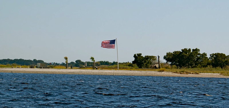
My observations so far indicate that we are having a warmer fall. In spite of a stiff breeze yesterday, we went boating. There were even some whitecaps in Swansboro Harbor when we got there.

We managed to go hide behind an island and try our luck at fall fishing. Unfortunately all we caught were lots of pinfish, a few croakers, and one hogfish. Apparently we are still feeling the effects of the 21 inches of rain that got dumped into our watershed on September 30.

Perhaps the water temperature which is still around 69F has something to do with it.

Still, we had fun, it was sunny and warm in the shelter of an island. There is little to complain about when you can go boating after the middle of October and still be comfortable wearing shorts and tee shirt.

I hope this run of great weather continues. My morning dock walk was very enjoyable even at a slightly cooler 56F.

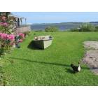
A picture from yesterday.

Reply With Quote Quick reply to this message

 
Old 10-20-2010, 09:57 AM
 
Location: VT
27 posts, read 53,492 times
Reputation: 18
I have been keeping track of your weather as well to keep a comparison to mine. I am very jealous! We had our first snow in the mountains in VT. There were reports of 20" drifts in places. I dream of your warmer weather and beautiful blue waters!!!
Reply With Quote Quick reply to this message
 
Old 10-21-2010, 11:05 AM
 
Location: Morehead City, NC
1,681 posts, read 6,030,928 times
Reputation: 1277
NOAA: Another Winter of Extremes in Store for U.S. as La Niña Strengthens
NOAA - National Oceanic and Atmospheric Administration - NOAA: Another Winter of Extremes in Store for U.S. as La Niña Strengthens

But all bets are off when it comes to coastal NC. Here is one of many reasons why. Republished here with permission.

Coastal Rain and Snow
By: Bill Hitchcock

The effect land and sea temperatures have on precipitation.

The weather on the coast is different from anywhere else. There is zone or an area that hugs the beaches that will be influenced by either the land temperatures or the water temperatures. This influence of temperatures has a direct impact as to what type of precipitation will fall within this area. The snow storm of February 13, 2010 demonstrates this phenomenon.


Take a look at the picture to the left. On the left side is a screen shot of the weather radar during the snow storm. The blue and pink areas represent snow. The green and yellow areas show rain. Going from south to north along the coastline notice how the snow fall runs right along the beach until the point of Hatteras. Then you see the snow go offshore of North Carolina and stay off shore as it continues working north off the Virginia coast.

Now take a look on the right side map. This map shows seawater surface temperatures the day of the snow storm. The pink and blue areas represent the coldest waters, somewhere in the 40 and lower 50 degrees. The yellow and red colors show the warmest temperatures with water temperatures on up into the high 60’s and higher.

Notice the warmer waters along the coast from Cape Fear all the way up to Cape Hatteras. The beach marked the dividing line of the warmer ocean waters and the colder ground temperatures. The precipitation that fell over land stayed as snow. But the precipitation that fell over the warmer ocean waters turned to rain.

Now take a look at what happens at the point of Hatteras. Notice the cold sea water surface temperatures that flow down from the north off of Virginia and wrap around Hatteras. The area of cold waters of the North Carolina and Virginia coast is the same area where the precipitation changed from rain to snow.

Wind speed and direction is strong factor in determining what type of precipitation the coast will have. During the winter the coast of North Carolina is dominated by a northerly wind. This helps to bring in the ground temperatures to the beaches and just offshore. Conversely a southerly wind will bring ocean water temperatures a short distance inland. The prevailing wind can determine what type of precipitation either will have.

Bill Hitchcock is the creator of the radio program and website Saltwater Catch
Reply With Quote Quick reply to this message
 
Old 10-22-2010, 04:54 AM
Status: "48 years in MD, 18 in NC" (set 15 days ago)
 
Location: Greenville, NC
2,309 posts, read 6,104,814 times
Reputation: 1430
Here's Richard's Forecast. Richard is not a meteorologist but his forecast record is better than most.

Weather in the Mid-Atlantic including NC & SC will be cool and windy. There will be many Alberta Clippers which will come down out of Canada all winter. The exact track of these fast moving "events" is impossible to tell for obvious reasons. Whether you're in warm air or cool air will depend on the track of the clippers. There may be one or two major snow storms which will probably produce heavy snow from NJ northward.
Reply With Quote Quick reply to this message
 
Old 10-22-2010, 05:27 AM
 
Location: Cape Carteret, NC
713 posts, read 3,929,917 times
Reputation: 553
Smile I'll vote for any forecast that keeps the snow in NJ

Quote:
Originally Posted by Richard Martin View Post
Here's Richard's Forecast. Richard is not a meteorologist but his forecast record is better than most.

Weather in the Mid-Atlantic including NC & SC will be cool and windy. There will be many Alberta Clippers which will come down out of Canada all winter. The exact track of these fast moving "events" is impossible to tell for obvious reasons. Whether you're in warm air or cool air will depend on the track of the clippers. There may be one or two major snow storms which will probably produce heavy snow from NJ northward.
Accuweather released their winter forecast (http://www.accuweather.com/blogs/news/story/40340/accuweathercom-winter-forecast-1.asp - broken link), and I will be happy if either they are right or you are right.

Their forecast says "Not much winter" for a broad swath of the country including us. I am on board with that. I like to take at least one boat ride a week even in winter.

Now we just need someone to read what the Old Farmer's Almanac is saying.
Reply With Quote Quick reply to this message
 
Old 10-22-2010, 07:25 AM
 
Location: Morehead City, NC
1,681 posts, read 6,030,928 times
Reputation: 1277
Watch for those low pressure systems to drop down and scoot off the NC coast and then head north along the coastline. First quarter of the year particularly.
Where exactly these systems hit are coastline will determine what we get. Think of Hatteras as the dividing line.
Anyone remember the March storm of '93? We had hurricane force winds here in Carteret County. Over 100mph to be exact.
Reply With Quote Quick reply to this message
 
Old 10-23-2010, 04:51 AM
Status: "48 years in MD, 18 in NC" (set 15 days ago)
 
Location: Greenville, NC
2,309 posts, read 6,104,814 times
Reputation: 1430
Long range forecasting is a whole lot easier than short range.

Weather patterns tend to change very slowly. Marty Bass, a TV weatherman at WJZ Ch 13 in Baltimore MD once said "weather is where the wind comes from." What that means is look to the past to see where the weather is going.

It didn't take a rocket scientist to see all of the storms last winter. If you remember, low pressure system after low pressure system kept riding up the eastern seaboard last summer. The trend continued right into the winter and the result was record breaking snows.

Low pressures riding up the coast this summer has been pretty rare. Only a few managed to do it. Despite a very active tropical weather season we only managed to get one tropical system even close to the coast. The reason for this is low pressure systems keep riding down from the north and pushing these offshore systems away.

It is these same low pressure systems from the north that will provide the Alberta Clippers that I talked about in my first post. They race right on through the whole continental mass and move offshore. You get a short blast of intense snow and then they leave a whole lot of cold air and wind in their wake.
Reply With Quote Quick reply to this message
 
Old 01-07-2011, 10:20 AM
Status: "48 years in MD, 18 in NC" (set 15 days ago)
 
Location: Greenville, NC
2,309 posts, read 6,104,814 times
Reputation: 1430
Quote:
Originally Posted by Richard Martin View Post
Here's Richard's Forecast. Richard is not a meteorologist but his forecast record is better than most.

Weather in the Mid-Atlantic including NC & SC will be cool and windy. There will be many Alberta Clippers which will come down out of Canada all winter. The exact track of these fast moving "events" is impossible to tell for obvious reasons. Whether you're in warm air or cool air will depend on the track of the clippers. There may be one or two major snow storms which will probably produce heavy snow from NJ northward.
I've been dead on so far. We're getting ready to have another Alberta Clipper tonight.
Reply With Quote Quick reply to this message
Please register to post and access all features of our very popular forum. It is free and quick. Over $68,000 in prizes has already been given out to active posters on our forum. Additional giveaways are planned.

Detailed information about all U.S. cities, counties, and zip codes on our site: City-data.com.


Reply
Please update this thread with any new information or opinions. This open thread is still read by thousands of people, so we encourage all additional points of view.

Quick Reply
Message:


Over $104,000 in prizes was already given out to active posters on our forum and additional giveaways are planned!

Go Back   City-Data Forum > U.S. Forums > North Carolina > Coastal North Carolina
Similar Threads

All times are GMT -6.

© 2005-2024, Advameg, Inc. · Please obey Forum Rules · Terms of Use and Privacy Policy · Bug Bounty

City-Data.com - Contact Us - Archive 1, 2, 3, 4, 5, 6, 7, 8, 9, 10, 11, 12, 13, 14, 15, 16, 17, 18, 19, 20, 21, 22, 23, 24, 25, 26, 27, 28, 29, 30, 31, 32, 33, 34, 35, 36, 37 - Top