Quote:
Originally Posted by mkurley

We will be leaving Myrtle Beach on Friday morning and driving to Nags Head for a check in on Saturday morning. We will be stopping for the night somewhere on the way to Nags head. We are looking for suggestions on a route to take and possible side trips or site seeing tips.
My idea is to drive through the souther beach towns of Ocean Isle, Holden Beach, and Oak Island. We want to check them out for a possible future vacation. Then continue onto they way to Nags head spending the night in Washington NC.
Any suggestions on site seeing along this route?
How about a different route?
Also any suggestions on a good place to stop for BBQ?
|
Another suggestion might be to head to Beaufort, then take the ferry from Cedar Isle to Ocracoke. Then drive up Ocracoke and take the ferry to Hatteras. Then take an easy cruise up Route 12 to Nags head.
We just drove from Myrtle Beach last week. It took us a little under three hours to Cape Carteret so the time to Beaufort should be about 3.5 hours or less. It should be about an hour from Beaufort to Cedar Isle.
This is the ferry schedule (http://www.ncdot.org/transit/ferry/routes/schedule/route005.html - broken link).
The ferry takes 2.5 hours
I checked and
the bridge work is done on Ocracoke.
This is
my Beaufort Travel Guide (http://coastalnc.org/beaufortnctravelguide - broken link). I recommend the Beaufort Inn. You can walk to all the shops and restaurants in Beaufort so it is a good place to relax after a car trip.
This is
Google Maps route to Cedar Island.
Directions are very simple, take Route 31 to Route 9 to Route 17.
Stay on 17 until you hit Route 24 in Jacksonville, follow it until it hits Route 70 in Morehead City. Follow 70 until you hit the ferry.
Once you get to Ocracoke, it is about 13 miles to the other end of the island and
another ferry (http://www.ncdot.org/transit/ferry/routes/schedule/route003.html - broken link) which is free and takes about 40 minutes. It runs every hour.
Once you are in Hatteras, the drive to Nags Head is a little under 60 miles and takes a little over an hour.
This is the
google map for that.
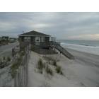
Here are some pictures of the "
Down East" area from Beaufort to Cedar Island.
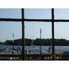
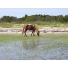
Here are some
Ocracoke pictures which include some shots from the short Ferry.
You are headed to a different world than Myrtle Beach. It took me
a number of hikes along the marshes to forget the high rises.

 Please register to participate in our discussions with 2 million other members - it's free and quick! Some forums can only be seen by registered members. After you create your account, you'll be able to customize options and access all our 15,000 new posts/day with fewer ads.