Please register to participate in our discussions with 2 million other members - it's free and quick! Some forums can only be seen by registered members. After you create your account, you'll be able to customize options and access all our 15,000 new posts/day with fewer ads.
I truly wish the Administrator would consider creating an urban planning forum so we urban design freaks could have our own place to debate, but until that day arises I am going to be posting a few polls over the next few days that I think are interesting.
Today I was doing some zooming around via Google Earth Street View in various parts of our country and saw dense communities with strict grid-shaped street networks, as well as low-density, sprawling areas with a lot of windy roads that ended abruptly, cul-de-sacs, and lollipops-on-a-stick. Some people prefer the latter because they enjoy the feel of their cars' handling as they hug these twists and turns, and they also enjoy the typically larger lot sizes such a design affords to them. However, I prefer the grid-shaped street network, and I will present my case below.
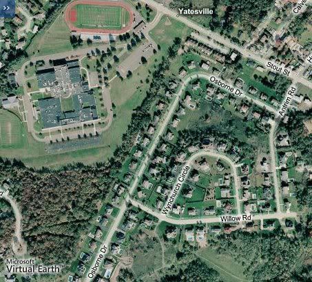
In a typical suburban-style street network it is very, very difficult to access any destinations unless one has a vehicle. For example, I have included satellite imagery of an upscale housing subdivision not far from my home that sits adjacent to my alma mater.
Even though students along Osborne Drive have their school quite literally in their backyards, due to property boundaries they must make a relatively long walk northwards along Osborne Drive to the intersection with Antrim Road, make a left, and then make a left onto Stout Street, where they will head up a steep hill to the school's main entrance. In a grid-shaped street system, those students could walk to school much more easily.
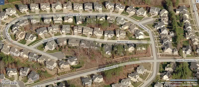
Here's another example from the Lehigh Valley of East-Central Pennsylvania of how inefficient many of today's suburbs are designed for pedestrians. If a child residing in the purple-looking two-story home just to the right of the Microsoft Virtual Earth label in the bottom-left-hand corner of the screen wanted to visit their friends' home just behind them along Dalgarven Drive, they'd have to eastward along White Dogwood Road, make a left onto Dalgarven Drive, make a left onto Manderston Lane, and then make a left onto the cul-de-sac that sits right behind their home so as not to trespass on others' property.
I just don't see how that can be construed as being "efficient" or "pedestrian-friendly" to me.
Good topic- my mother and I were just talking about this- we were comparing Chicago and Charlotte, NC streets and how we always seemed to get lost because we were used to Chicago's grid street system
I like grids better overall but throw in some long diagonal streets to break up the monotony like in DC or something. LA's street grid is just too big with virtually no diagonal streets breaking up the huge grid, some of the streets in LA, like Sepulveda Blvd, are literally over 40 miles long in one long straight line.
Good topic- my mother and I were just talking about this- we were comparing Chicago and Charlotte, NC streets and how we always seemed to get lost because we were used to Chicago's grid street system
I'm obviously biased in the direction grids myself, since they make it so much easier to get around. In Scranton's downtown and adjacent historic "Hill" neighborhood, the north/south arterials are typically alternating one-way streets named after U.S. Presidents in the order of their presidency (Washington Avenue, Adams Avenue, Jefferson Avenue, Madison Avenue, Monroe Avenue, etc.) as you head west to east. Therefore if you have a basic knowledge of our history and are on Adams Avenue and know you need to get to Madison Avenue, you know you are two blocks away from where you need to be. You don't get that with "Burning Bush Terrace." Manhattan is another great example of the efficient grid system with the east/west streets being numbered sequentially (1st Street, 2nd Street, 3rd Street, etc.) as you head from the Financial District all the way on up to Harlem. Then there are numbered avenues running north/south with just a couple of oddballs (like Broadway) thrown in for good measure. It's impossible to "get lost" in Manhattan unless you're an idiot. However, it's very easy to get lost in a place like Pittsburgh, where the varied topography has made such a grid system pretty difficult to implement.
I think the more interesting question would compare Chicago or New York to Boston or Pittsburgh. The urban grid is easy to get around, and works well for transit. A medieval street system, though, has alot of visual appeal. A street that dead-ends in a church is a pretty awesome sight.
I think there's actually two kinds of "haphazard" street styles here:
Up until the industrial revolution, very few cities were built to a grid and streets were pointing every which way. However, in the 18th and expecially 19th century, there was an interest in building great 90-degree-angle gridded cities, and this went on until WW2. Almost all American cities had their start and/or major periods of growth within this time period so they are built in large way to a grid. However, it was after WW2 that suburbinization brought this crazy and inefficient new auto-only-based haphazard street pattern.
But if it's between the grids of 1750-1950 versus the haphazard suburban developments of 1950 to present, I would go with the grid.
I'll take a grid, as someone said, with a few diagonals for interest. I would also add a few circles, that type of thing. I'm not a big fan of the "lollipop on a stick", though I don't have a big problem with cul de sacs within subdivisions. Grids are easier to find your way around, but can get boring, and you also have to take topography (hills, streams, etc) into acct.
Please register to post and access all features of our very popular forum. It is free and quick. Over $68,000 in prizes has already been given out to active posters on our forum. Additional giveaways are planned.
Detailed information about all U.S. cities, counties, and zip codes on our site: City-data.com.

 Please register to participate in our discussions with 2 million other members - it's free and quick! Some forums can only be seen by registered members. After you create your account, you'll be able to customize options and access all our 15,000 new posts/day with fewer ads.