04-20-2009, 12:31 AM
Location: New Mexico to Texas
4,552 posts, read
15,029,225 times
Reputation: 2171
Albuquerque suburbs
new development area
Rio Rancho, NM rio rancho new mexico - Google Maps >
Last edited by desert sun; 04-20-2009 at 01:08 AM ..
04-20-2009, 01:35 AM
Location: Baton Rouge
1,734 posts, read
5,689,395 times
Reputation: 699
Quote:
Originally Posted by
thedudewiththeplan
Wow, nice to see some suburbs with actual density. Outside of Miami, there are not to many cities that have dense suburbs in the south.
I think Miami and New Orleans are pretty much the only major cities in the south with dense suburbs.
04-20-2009, 05:21 AM
3,631 posts, read
10,236,486 times
Reputation: 2039
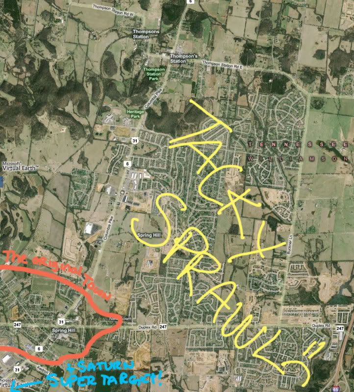
This is a town near where I used to live in Tennessee. It's Spring Hill. King of the tacky sprawl. The people running the place had nor do they have any sense of planning, unless your sense of planning is put down as many ugly subdivisions and strip malls as you can. Oh and let's not forget putting Home Depot in the town center. City pride sponsored by Home Depot!
The illustration is very clear. that little red area is where the boundaries of the town were (or smaller even) when my family moved down there 15 years ago. the rest of it has bled out into the countryside in the last 15 years thanks to the people that think it's a good idea to drive 40 or more miles to all parts of Nashville for work. I refuse to go into the horrid place when i visit my parents..
i mean, there is so much sprawl, i had to move the "old" town to the very corner of the map!
04-20-2009, 06:47 AM
6,041 posts, read
11,473,258 times
Reputation: 2386
Quote:
Originally Posted by
MetroBTR
Some Upper Class Areas of Baton Rouge Steele Place/Garden District:
Baton Rouge - Google Maps
Baton Rouge - Google Maps
City Park/University Lakes:
Baton Rouge - Google Maps
Baton Rouge - Google Maps
Some Upper Middle Class Areas Bocage
Bocage Boulevard, Baton Rouge, La - Google Maps
Old Goodwood
to: 30.414825,-91.16086 - Google Maps
Some Middle Class Areas Broadmoor/Sherwood Forest
to: 30.414825,-91.16086 - Google Maps
to: 30.414825,-91.16086 - Google Maps
Southdowns
to: 30.414825,-91.16086 - Google Maps
Kenilworth
to: 30.414825,-91.16086 - Google Maps
Some Working/Lower Class areas of Baton Rouge Scotlandville
to: 30.414825,-91.16086 - Google Maps
Mid City
to: 30.414825,-91.16086 - Google Maps
Glen Oaks
Glen Oaks, Baton Rouge, La - Google Maps
Suburbia Denham Springs
Glen Oaks, Baton Rouge, La - Google Maps
Prairieville
Glen Oaks, Baton Rouge, La - Google Maps
Zachary
Zachary, La - Google Maps
Plaquemine
Plaquemine, La - Google Maps
Port Allen/Brusly
Port Allen, La - Google Maps
Santa Maria
Port Allen, La - Google Maps
Shenandoah
Port Allen, La - Google Maps
Okay, I'm done lol
That looks like a nice area.
04-20-2009, 08:50 AM
3,368 posts, read
11,673,266 times
Reputation: 1701
Thanks for the links/pics, everyone. Keep them coming!
04-20-2009, 11:55 AM
Location: New Mexico to Texas
4,552 posts, read
15,029,225 times
Reputation: 2171
Albuquerque,NM suburbs
Corrales,NM
Link: <
corrales,nm - Google Maps >
Link: <
corrales,nm - Google Maps >
Belen,NM
Link: <
belen,nm - Google Maps >
Link: <
belen,nm - Google Maps >
Link: <
belen,nm - Google Maps >
Los Lunas,NM
Link: <
belen,nm - Google Maps >
Link: <
belen,nm - Google Maps >
Rio Rancho,NM
Link: <
belen,nm - Google Maps >
Link: <
belen,nm - Google Maps >
Link: <
belen,nm - Google Maps >
Tijeras,NM
Link: <
belen,nm - Google Maps >
Last edited by desert sun; 04-20-2009 at 12:13 PM ..
04-20-2009, 12:00 PM
Location: Underneath the Pecan Tree
15,982 posts, read
35,220,926 times
Reputation: 7428
Quote:
Originally Posted by
MetroBTR
I think Miami and New Orleans are pretty much the only major cities in the south with dense suburbs.
Houston and Dallas as well.
04-20-2009, 12:03 PM
Location: Concrete jungle where dreams are made of.
8,900 posts, read
15,942,478 times
Reputation: 1819
Quote:
Originally Posted by
jluke65780
Houston and Dallas as well.
Show some links to us so we can judge that.
04-20-2009, 12:16 PM
3,368 posts, read
11,673,266 times
Reputation: 1701
Quote:
Originally Posted by
Rachael84
Show some links to us so we can judge that.
And while you're waiting, put up some links/pics of Long Island.
04-20-2009, 12:41 PM
93,392 posts, read
124,009,048 times
Reputation: 18268
Syracuse NY area:
Mattydale(where I live):
boulevard drive, mattydale ny - Google Maps
Village of North Syracuse:
http://maps.google.com/maps?f=q&sour...54545454545455
Village of Liverpool:
http://maps.google.com/maps?f=q&sour...18181818181818
Village of Solvay:
http://maps.google.com/maps?f=q&sour...48051948051948
Village of East Syracuse:
http://maps.google.com/maps?f=q&sour...591535718,,0,5
Village of Baldwinsville:
http://maps.google.com/maps?f=q&sour...89610389610389
Village of Fayetteville:
http://maps.google.com/maps?f=q&sour...900545133,,0,5
Village of Manlius:
http://maps.google.com/maps?f=q&sour...61038961038962
Fairmount(Western suburb in town of Camillus):
http://maps.google.com/maps?f=q&sour...869012282,,0,5
Carrier Circle(in East Syracuse area):
http://maps.google.com/maps?f=q&sour...265918428,,0,5
Village of Minoa:
http://maps.google.com/maps?f=q&sour...&cbp=12,0,,0,5
Route 31 strip in Clay:
http://maps.google.com/maps?f=q&sour...285527721,,0,5
Cicero:
http://maps.google.com/maps?f=q&sour...49350649350649
Nedrow:
http://maps.google.com/maps?f=q&sour...45454545454545
Liverpool area(town of Clay):
http://maps.google.com/maps?f=q&sour...601911406,,0,5
Liverpool area(town of Salina):
http://maps.google.com/maps?f=q&sour...64935064935065
DeWitt:
http://maps.google.com/maps?f=q&sour...49350649350649
Village of Camillus:
http://maps.google.com/maps?f=q&sour...223569084,,0,5
Lyndon(part of town of DeWitt):
http://maps.google.com/maps?f=q&sour...269483693,,0,5
Lyncourt(a part of the town of Salina):
http://maps.google.com/maps?f=q&sour...90909090909097
Lakeland(a part of the town of Geddes):
http://maps.google.com/maps?f=q&sour...87012987012987
Galeville(a part of town of Salina/Liverpool Schools):
http://maps.google.com/maps?f=q&sour...09090909090908
Franklin Park and Park Hill neighborhoods(East Syracuse area/a part of the town of DeWitt):
http://maps.google.com/maps?f=q&sour...323590544,,0,5
Indian Village(is actually the Onondaga Indian Nation Reservation and they go to LaFayette Schools):
http://maps.google.com/maps?f=q&sour...61038961038962
Brewerton(is split between Onondaga(town of Cicero) and Oswego(town of Hastings) Counties):
http://maps.google.com/maps?f=q&sour...002317475,,0,5
I-690 heading East from the Baldwinsville area:
http://maps.google.com/maps?f=q&sour...31168831168838
I-81 heading South from the Liverpool area:
http://maps.google.com/maps?f=q&sour...257093386,,0,5
I-90(NY State Thruway) in the East Syracuse area:
http://maps.google.com/maps?f=q&sour...62337662337663
Jamesville(a part of the town of DeWitt):
http://maps.google.com/maps?hl=en&q=...14285714285715
You can play around and look at the areas around the villages and hamlets too.
Here's some small towns in the immediate area too:
Village of Skaneateles:
http://maps.google.com/maps?f=q&sour...437207967,,0,5
Village of Elbridge:
http://maps.google.com/maps?f=q&sour...257199364,,0,5
Last edited by ckhthankgod; 04-20-2009 at 01:46 PM ..
Please register City-data.com

 Please register to participate in our discussions with 2 million other members - it's free and quick! Some forums can only be seen by registered members. After you create your account, you'll be able to customize options and access all our 15,000 new posts/day with fewer ads.