No threat to land.
500 PM EDT TUE JUN 19 2012
...ANOTHER HIGH-LATITUDE TROPICAL STORM FORMS...NO THREAT TO LAND...
SUMMARY OF 500 PM EDT...2100 UTC...INFORMATION
----------------------------------------------
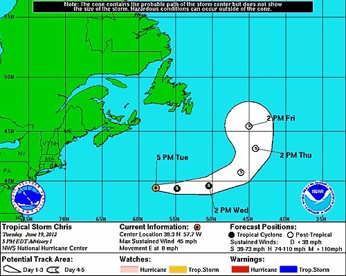
LOCATION...39.3N 57.7W
ABOUT 560 MI...905 KM SSW OF CAPE RACE NEWFOUNDLAND
MAXIMUM SUSTAINED WINDS...45 MPH...75 KM/H
PRESENT MOVEMENT...E OR 90 DEGREES AT 8 MPH...13 KM/H
MINIMUM CENTRAL PRESSURE...1005 MB...29.68 INCHES
WATCHES AND WARNINGS
--------------------
THERE ARE NO COASTAL WATCHES OR WARNINGS IN EFFECT.
DISCUSSION AND 48-HOUR OUTLOOK
------------------------------
SATELLITE IMAGERY INDICATES THE NON-TROPICAL LOW PRESSURE AREA
LOCATED WELL SOUTHEAST OF THE CANADIAN MARITIMES HAS ACQUIRED
TROPICAL CHARACTERISTICS.
AT 500 PM EDT...2100 UTC...THE CENTER OF TROPICAL STORM CHRIS WAS
LOCATED NEAR LATITUDE 39.3 NORTH...LONGITUDE 57.7 WEST. CHRIS IS
MOVING TOWARD THE EAST NEAR 8 MPH...13 KM/H. AN EASTWARD MOTION
WITH AN INCREASE IN FORWARD SPEED IS FORECAST DURING THE NEXT 24
HOURS. A TURN TOWARD THE NORTHEAST...THEN NORTH IS EXPECTED
WEDNESDAY NIGHT AND THURSDAY.
MAXIMUM SUSTAINED WINDS ARE NEAR 45 MPH...75 KM/H...WITH HIGHER
GUSTS. LITTLE CHANGE IN STRENGTH IS EXPECTED DURING THE NEXT 48
HOURS. CHRIS IS FORECAST TO BECOME A POST-TROPICAL CYCLONE
WEDNESDAY NIGHT OR THURSDAY.
TROPICAL-STORM-FORCE WINDS EXTEND OUTWARD UP TO 70 MILES...110 KM
FROM THE CENTER.
ESTIMATED MINIMUM CENTRAL PRESSURE IS 1005 MB...29.68 INCHES

 Please register to participate in our discussions with 2 million other members - it's free and quick! Some forums can only be seen by registered members. After you create your account, you'll be able to customize options and access all our 15,000 new posts/day with fewer ads.


