Please register to participate in our discussions with 2 million other members - it's free and quick! Some forums can only be seen by registered members. After you create your account, you'll be able to customize options and access all our 15,000 new posts/day with fewer ads.
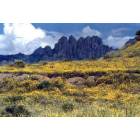
Made the loop from Alamogordo to Cloudcroft, Sunspot, Timberon, Piñon, Weed and back to Clooudcroft and then home. Even though it is mid-November and the National Solar Observatory is at 9,200 feet, it was still shirt-sleeve weather.
The road gets rough and lonesome south of Timberon. I got a huge kick out of this old sign, nearly overgrown, where the E-11 road crosses the E-12. That's Piñon if you turn left, El Paso if you turn right.
I found the track that leads into a canyon my Texas relatives homesteaded in 1884, but thought it unwise to continue too far into it by myself as the road was steep, narrow and rutted with washouts. It's a sad thing to get old and ... prudent ...
Actually, people traveling between US-54 (El Paso route) and Timberon should keep to the "improved" gravel roads. Many a modular home was hauled over those gravel roads when Timberon was first being developed. It remained the preferred route for years for those going to and from Timberon from the southwest. It wasn't until about 15 years ago that the Sacramento Canyon road (from near Sunspot to Timberon) was finally graded and paved. Before that it was frequently damaged by hard rains and was rough, twisty and narrow.
The Owen Prather Highway...
The main gravel road across the Otero Mesa (south end of Sacramento Mtns.) is named for the ornery old rancher Owen Prather, who defied the US government by refusing to move off of his ranch, finally winning approval to live in his home until his death. His story is an interesting one.
Joqua, John Prather was a great American. God rest his soul.
I tried to correct my earlier post but the time for editing had run out. Owen Prather - for whom the highway was named - was the brother who homesteaded the Prather ranch. It was John Prather who was still living on and working the ranch at the time the government exercised "eminent domain" over it - or however they acquired it.
Great pics, OB. It's been fun following your relocation. Really happy for you. Gives my husband and I hope that we'll actually be able to do it some day.
LilyMae, so far it has been wonderful. Having spent almost all 64 years of my life in the Pacific Northwest, I do not miss the rain, the mud, the wet cold or the algae on my truck one bit. And in terms of natural and human history, this section of New Mexico is exceptionally rich.
Not much of a photo here, but the very idea that Alamogordo and the Tularosa Basin are 5,000 feet below still boggles me.
I do not miss the rain, the mud, the wet cold or the algae...
...and mold and mildew!! And in recent years, the hurricane force winds at times if one lives on the coast. Those winds keep my son busy since he supervises line crews for Puget Power in the Olympia area.
Glad you are enjoying! I had a terrific time exploring all the nooks and crannies of the Sacramentos by car, foot, and dirt bike during the three years we lived in Alamogordo, and miss those mountains often. I am appending some GPS waypoints to give you ideas for exploring! Lots more of the same when I can dig through my old GPS data. An9other good lead would be the USFS station outside Cloudcroft. They would have maps with all the trailheads, FS roads, etc.
Have fun!
Bob
Benson Ridge - tied for highest point in Sacramentos - N32° 51.590' W105° 45.761'
Bluff Spring - N32° 49.872' W105° 44.241'
Car with a tree in it (pvt land) - N32° 42.907' W105° 34.757'
Cathay Vista - N32° 48.439' W105° 47.999'
Dry Canyon hang glider launch (good view over Alamo) - N32° 55.632' W105° 53.145'
FS 506 Owen Prather Rd west entrance (with 4wd, can get way up into Southern Sacs here) - N32° 31.858' W106° 01.656'
Karr Canyon picnic spot (nice in Fall) - N32° 53.839' W105° 48.782'
Long Ridge radio towers - N32° 49.805' W105° 53.249'
Lower Bridal Veil falls - N32° 57.463' W105° 51.849'
Mayhill Cafe (Rocky Mtn Oysters, blech) - N32° 53.373' W105° 28.683'
Nelson Vista - N32° 54.389' W105° 46.616'
Nuckleweed Cafe (great food if still open) - N32° 59.871' W105° 52.009'
Petting Zoo (family friendly) - N32° 53.683' W105° 13.404'
Sacramaento Tower (abandoned, incredible views) - N32° 44.809' W105° 45.650'
Ski Cloudcroft - N32° 56.956' W105° 42.366'
Snowplay - N32° 58.572' W105° 43.632'
Sunspot, NM - N32° 47.238' W105° 49.068'
Tunnel Vista (note Indian cave on southern wall above) - N32° 56.805' W105° 51.399'
UNM Apache Observatory - N32° 46.722' W105° 48.832'
Water tanks (abandoned ranchhouse nearby on pvt land) - N32° 43.584' W105° 49.299'
Weed Cafe - N32° 48.140' W105° 31.023'
Weed store (gas) - N32° 48.441' W105° 30.553'
WSMR Alamo tracking station (mil) - N32° 52.420' W105° 48.675'
WSMR Mountain Lab (abandoned; old wind tunnel etc) - N32° 47.756' W105° 47.799'
And further afield:
Abandoned Mill, Sierra Blancas (back route around White Mtns) - N33° 29.265' W105° 46.971'
Billy the Kid's jail, Las Cruces - N32° 16.455' W106° 47.704'
Capitan - N33° 36.342' W105° 21.566'
Coas Bookstore, Las Cruces - N32° 18.712' W106° 46.760'
Crest Trail - N33° 25.603' W105° 44.046'
Dripping Springs trail , Las cruces - N32° 19.412' W106° 34.906'
El Paso Tram - N31° 48.567' W106° 28.690'
Fort Stanton (annual festival) - N33° 29.714' W105° 31.420'
Hurd Gallery - N33° 24.689' W105° 20.049'
Iris Farm (visit circa May buring bloom) - N33° 23.371' W105° 16.935'
Jicarilla schoolhouse (abandoned) - N33° 51.680' W105° 39.289'
Jicarilla mining camp (abandoned, very cool, pvt) - N33° 52.163' W105° 39.781'
Jicarilla Mine (pvt) - N33° 50.441' W105° 40.748'
La Luz dirt bike play area (pvt?) - N32° 57.964' W105° 56.547'
Lincoln County Fairground (excellent annual rodeo) - N33° 32.487' W105° 34.438'
Lincoln, NM (Park Service - Billy the Kid) - N33° 29.541' W105° 23.153'
NM Farming Museum, Las Cruces - N32° 17.869' W106° 43.500'
Red Sands dirt bike trails (open through winter) - N32° 35.449' W106° 00.790'
Saddleblanket store, El Paso - N31° 46.446' W106° 23.029'
Three Rivers Petroglyphs - N33° 20.805' W105° 59.766'
Trail to Monjeau Lookout - N33° 23.922' W105° 40.849'
White Oak, NM - N33° 44.854' W105° 44.182'
White Oak Pottery (quirky and wonderful) - N33° 46.603' W105° 41.630'
White Sands Speedway (pvt) - N33° 08.083' W106° 02.703'
Windy Point, Sierra Blanca - N33° 23.738' W105° 45.849'
Please register to post and access all features of our very popular forum. It is free and quick. Over $68,000 in prizes has already been given out to active posters on our forum. Additional giveaways are planned.
Detailed information about all U.S. cities, counties, and zip codes on our site: City-data.com.


 Please register to participate in our discussions with 2 million other members - it's free and quick! Some forums can only be seen by registered members. After you create your account, you'll be able to customize options and access all our 15,000 new posts/day with fewer ads.