Census metro areas are bogus (suburbs, market, Houston, green)
Please register to participate in our discussions with 2 million other members - it's free and quick! Some forums can only be seen by registered members. After you create your account, you'll be able to customize options and access all our 15,000 new posts/day with fewer ads.
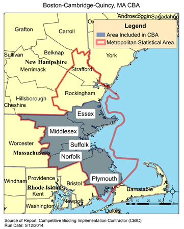
Yes! I noticed that too. Strafford county is way too far north of Boston. Pretty crazy that it's included.
Imo this is the best and most effective map for Boston
Light Blue represents the area in Massachusetts known as Greater Boston, while Dark Blue represents the Metro-Boston area and Red represents the City of Boston.
No new Hampshire at all. This varies from the Census areas quite a lot.
Location: Live:Downtown Phoenix, AZ/Work:Greater Los Angeles, CA
27,606 posts, read 14,594,858 times
Reputation: 9169
Quote:
Originally Posted by Spade
Why is LA hard to believe? 10 million people live in the county. That’s more than every other current metro not named New York. Should they add Ventura to show that it really should be 14 million in the metro or something?
Ventura County is part of Greater LA. People who live in places like Simi Valley and Thousand Oaks definitely commute into the SFV or the Westside of LA to work
The data is out for 2019 on data.census.gov for urban areas. Ill update my demographics 2019 thread with some of that.
Urban areas are terrible if any natural object gets in the way. The SF urban area ends just a few miles east of the Bay at the Berkeley Hills, and then there's a completely separate "Concord, CA urban area" which is ridiculous.
I agree that urban areas are just as bad as MSAs. I looked at a bunch of examples and most are bogus. For example, half of the town of Windsor, CT, a direct suburb of Hartford, has the entire northern portion of the town excluded simply because the population density is too low. This area has plenty of low density neighborhoods with people who have a short commute to Hartford. Ridiculous
I think it's easier to "pull in" rural counties. Boston's MSA has the oddity of including Strafford County, NH which is really disconnected from the city via highway and rail*. It's inclusion in the MSA technically makes the University of New Hampshire a Boston-area school, which is wild.
*The Downeaster notwithstanding.
New England is extra bogus since our counties are sort of arbitrary and random. One of the most bogus, in my opinion, is Portland, ME which is merely 3 counties (York, Cumberland, and Sagadahoc), but covers a land area more than double the size of Rhode Island and only has a little over 500,000 people. It's mostly pretty rural and about 1/2 of it either functions independently or had more ties to places like Portsmouth/Dover NH, Lewiston ME, or August ME, than Portland.
No one even knows that's a place. I've never heard the words "Strafford County" nor have I seen those words outside of C-D.
To be fair, Dover and Durham are more recognizable places than Strafford, just like Nashua and Portsmouth are more recognizable than Hillsborough and Rockingham.
To be fair, Dover and Durham are more recognizable places than Strafford, just like Nashua and Portsmouth are more recognizable than Hillsborough and Rockingham.
Agreed.
Never heard of either Dover nor Durham.
Please register to post and access all features of our very popular forum. It is free and quick. Over $68,000 in prizes has already been given out to active posters on our forum. Additional giveaways are planned.
Detailed information about all U.S. cities, counties, and zip codes on our site: City-data.com.

 Please register to participate in our discussions with 2 million other members - it's free and quick! Some forums can only be seen by registered members. After you create your account, you'll be able to customize options and access all our 15,000 new posts/day with fewer ads.