Urban SPRAWL....which cities have it bad? (Baltimore, Kansas, Massachusetts)
Please register to participate in our discussions with 2 million other members - it's free and quick! Some forums can only be seen by registered members. After you create your account, you'll be able to customize options and access all our 15,000 new posts/day with fewer ads.
My point is...a city can be a "much different place" due to booming population growth and development, but it's the same city underneath with "newness" on the surface. That surface is many times what non-residents and people unfamiliar with the city will use to label it a "new" city. To those of us familiar with the city for many years, we still see the same city at ground level.
Atlanta's population growth has been trememndous since 2007, increasing by 41%. But it's nothing new...it's the highest percentage of any decade since 1900, but each decade has seen huge amounts of growth:
Do you mean it's metro growth? A metro that takes up practically the entire state of Georgia? I never liked how they 'determined' msa's.
Of course I mean metro growth...otherwise Atlanta's population declined through many of those decades.
As you can see, Atlanta's MSA does not even nearly include all of Georgia. There are 72 counties in the state that are not part of Metro Atlanta. Metro Atlanta - Wikipedia, the free encyclopedia
It's pretty common for cities across the U.S. to have large metro areas:
Your figures and map for "Greater Boston" are way off. The map shows about 1/3 of Massachusetts, and then it says 7,497 square miles....however the entire state of Massachusetts is only 7,842 square miles. Greater Boston is 4,674 square miles and has a population of 4,411,835 according to the link provided....however Boston's MSA is 4,511 square miles with an estimated population of 4,522,858. Then again, the source is wikipedia so there's bound to be conflicting information.
Your figures and map for "Greater Boston" are way off. The map shows about 1/3 of Massachusetts, and then it says 7,497 square miles....however the entire state of Massachusetts is only 7,842 square miles. Greater Boston is 4,674 square miles and has a population of 4,411,835 according to the link provided....however Boston's MSA is 4,511 square miles with an estimated population of 4,522,858. Then again, the source is wikipedia so there's bound to be conflicting information.
Those numbers are for the Boston-Worcester-Manchester CSA.
I mean, Cleveland MSA doesn't even include it's bordering county of Summit. That was my whole point, some of these MSA's are so large. Heck, to say Cleveland and Akron aren't in the same metro is just a bid absurd to me.
Cleveland's MSA is 2.25 million. It's only 5 counties and a small portion of n. east Ohio. While Cincy has a 15 counties included.
Realistically, Cleveland's MSA should include the Akron/Canton region bringing in the MSA of Cleveland to 3.4 million.
You can see the population density of the state, if it helps getting an understanding at all. I know there are certain ways they determine MSA, but I don't think they follow basic common sense.
Yea I know...Wikipedia says the Boston CSA is over 10,000+ square miles, but I've always been suspicious of those numbers since it would be nearly 1.5 times the size of the state of Massachusetts.
Yea I know...Wikipedia says the Boston CSA is over 10,000+ square miles, but I've always been suspicious of those numbers since it would be nearly 1.5 times the size of the state of Massachusetts.
I couldn't find anything on Wikipedia...but the 10,000 square miles figure is for the state of Massechusetts. I think the site I referenced was from 2000, judging from the population figure:
"The CSA is approximately 7,497 square miles with a population of 5.7 million persons." Yahoo! Search
It looks like Boston's CSA includes most of Rhode Island as well as some of New Hampshire.
Please register to post and access all features of our very popular forum. It is free and quick. Over $68,000 in prizes has already been given out to active posters on our forum. Additional giveaways are planned.
Detailed information about all U.S. cities, counties, and zip codes on our site: City-data.com.

 Please register to participate in our discussions with 2 million other members - it's free and quick! Some forums can only be seen by registered members. After you create your account, you'll be able to customize options and access all our 15,000 new posts/day with fewer ads.
 I never liked how they 'determined' msa's.
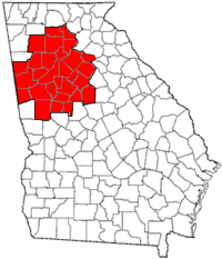


 You can see the population density of the state, if it helps getting an understanding at all. I know there are certain ways they determine MSA, but I don't think they follow basic common sense.
