Fall 2012 Thread (September - November) (Canada, dew point, moving, cloudy)
Please register to participate in our discussions with 2 million other members - it's free and quick! Some forums can only be seen by registered members. After you create your account, you'll be able to customize options and access all our 15,000 new posts/day with fewer ads.
Here are the trees I mentioned earlier. I think I saw them like this last year, I don't remember. Can't wait for fall!
Spoiler
Oh thats interesting. Thanks. I can't wait either. Reminds me to get the foliage links ready. You should check your posts from last year and see if you posted anything about the color changes. Thats whats great about forums, we can go back in time and confirm things and help our memories.. :-)
He's in southern Finland. It's strange that going by wikipedia's stats, Helsinki is about a degree warmer than Tallinn throughout the year. It's also sunnier.
Was summer terrible in Finland? July was more than a degree warmer than normal here but everyone's bitching about how cold it is. I guess they got used to the last two record hot summers.
Northern Lapland seems to be dropping near freezing regularly now but it's a cold wave, usually nights drop below freezing at the end of September there.
Yes, I've noticed the same. The only reason I can think of why Helsinki is a bit warmer could have something to do with air flow, direction of clouds and that Tallinn is more susceptible to weather fronts from the east. In contrast, that should lead to warmer summer temperatures in Estonia. Or then the data for Tallinn is just out of date.
And yes, part of the feeling that it has been a "cold" summer is just because the last two ones have been so hot, I'm not gonna deny that. July was temperature-wise pretty average, and June 1.0-1.5°C colder than usual in large parts of the country.
The big difference is the lack of warm days, which gives the feeling that the summer never quite got going. The amount of >25°C days has been the lowest since 1998.
And it has been rainy. In many parts either June or July (or both) were much rainier than usual (some places got 200% of the average).
In Lapland the mercury drops below the freezing point one or two nights in August on average, so there's no odd in that.
In Lapland the mercury drops below the freezing point one or two nights in August on average, so there's no odd in that.
If there are more freezes than the average then that is odd. I know that most of Lapland gets a freeze or two in a typical August, but "regular" freezes aren't typical (assuming the post was accurate).
If there are more freezes than the average then that is odd. I know that most of Lapland gets a freeze or two in a typical August, but "regular" freezes aren't typical (assuming the post was accurate).
Perhaps I was a bit inaccurate. The lowest temperature last night was -0.8°C. In Swedish Lapland they recorded exactly the same. The next two nights should have lows of 3-8°C, but at the end of the week, new at least near-freezing nights may be possible.
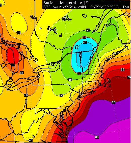
GFS Fantasy range for Sept 6th showing 20s in Vermont. While Europe continues to be torched with heat, its looking like the polar vortex wants to drop into the U.S . Getting interesting.
A cold airmass will remain over the Northern Rockies Friday night
as a ridge begins to build. The clearing associated with the ridge
will allow temperatures to drop by Saturday morning. Many
locations will be in the 30s, while valleys along the divide could
see temperatures in the upper 20s. The ridge will steadily build
through out the weekend allowing for warm and dry conditions. The
upper level flow will become southwesterly by Monday which will
allow for the warm conditions but afternoon winds will be
increasing. The dry conditions and winds could cause fire weather
concerns for the first part of next week. The models are still
struggling on the strength and timing of the next cold front for
mid next week.
Met office has lowered forecast min to 4c for Scotland northwards. Do any of you think we have a chance of a first air frost considering they are always too pessimistic with their temp predications? They do say a ground frost.
They predicted 7c a few weeks ago and a local station got down to 3c
Here is the final autumn forecast for the British Isles. There is a pattern emerging with the Greenland high staying to the north according to most models over the Autumn. This is surprising because last summer the Greenland high was there all summer like this year but it was replaced by the azores in the autumn, giving us a mild winter. If it stays probably a cold one. I don't think I agree with the Jamstec temperature predications, as it seems to flip back and forth quite a bit and it really isn't giving the British Isles a signal at all.
Met office has lowered forecast min to 4c for Scotland northwards. Do any of you think we have a chance of a first air frost considering they are always too pessimistic with their temp predications? They do say a ground frost.
They predicted 7c a few weeks ago and a local station got down to 3c
That's 39F. On a clear, calm night there usually will be rooftop frost. Ground frost is also possible at that temperature. It of course depends on whether the temperature is warmer or cooler than forecast. If it's warmer there isn't much of a chance of frost of any kind, but if it's cooler you probably will see frost somewhere if it's clear and calm.
Please register to post and access all features of our very popular forum. It is free and quick. Over $68,000 in prizes has already been given out to active posters on our forum. Additional giveaways are planned.
Detailed information about all U.S. cities, counties, and zip codes on our site: City-data.com.

 Please register to participate in our discussions with 2 million other members - it's free and quick! Some forums can only be seen by registered members. After you create your account, you'll be able to customize options and access all our 15,000 new posts/day with fewer ads.


 You should check your posts from last year and see if you posted anything about the color changes. Thats whats great about forums, we can go back in time and confirm things and help our memories.. :-)