Please register to participate in our discussions with 2 million other members - it's free and quick! Some forums can only be seen by registered members. After you create your account, you'll be able to customize options and access all our 15,000 new posts/day with fewer ads.
I held off starting this because I just dont see anything solid yet but something seems to be brewing.
Unlike last few times there was some consistancy. But since the Euro is showing something now, I figure we start tracking it. I'll post some stuff later on..
Time Frame will be 19th to 24th. Could be one event, it might actualy be 2 events. We'll have to see if a phase happens.
Latest GFS just came out continues to show a storm moving up the coast, stalling out and lasting days along the coast. Indicating major blocking going on.
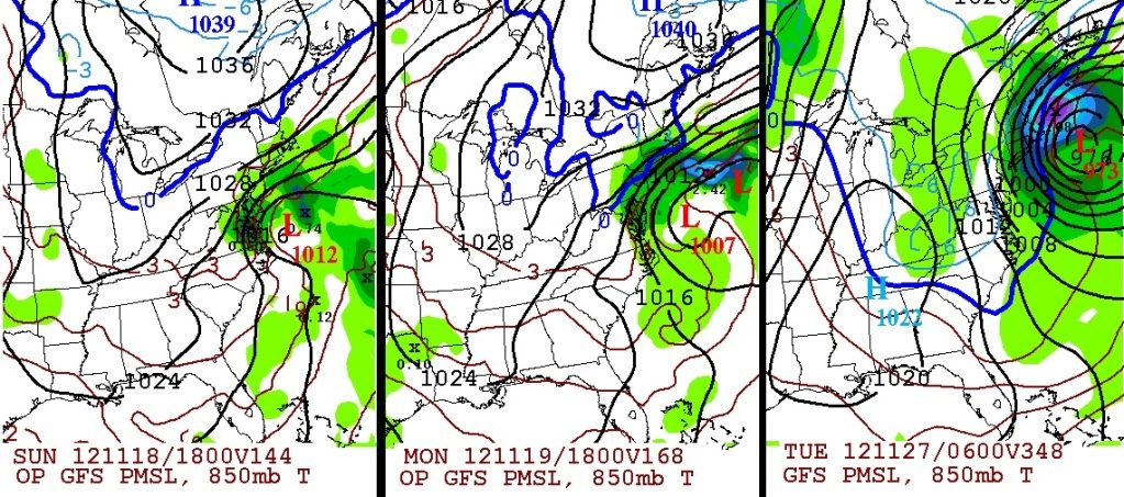
3 screen shots here.
Left = Sun the 18th Raining over Virginia, Baltimore, showers into NJ, CT, MA
Middle = Monday the 19th. Still raining over Baltimore southern NJ but snowing over Southern NY, northern CT and MA.
Right = Tuesday the 27th. Bombs away. 973mb low with the 850mb line off the coast. Blizzard like conditions for southern Maine, NH, RI, MA. Snow down to CT & NJ coast.
3 things to keep in mind...
A. This is the GFS (not performed well)
B. 3rd frame is waaayy long range and considered fantasy land.
C. This is not a locked in senario, I'm just showing what the GFS just produced.
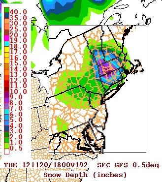
You can see the snow totals here 6-9" of snow from that run for Northern CT and MA for right before Thanksgiving.
Moral of the story something is brewing, it's just not consistant yet and too early to know. Lets keep watching for consistancy.
if you guys find an article from somewhere regarding this, please post it.
Also note... the system coming into the Pacific NorthWest will have to be sampled before we get a better idea. In other words, Winter Weather Flights have to go into the system out west and grab samples so the models can injest them and produce a result with the system in the data.
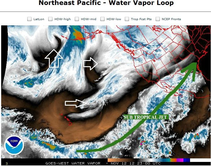
Here's a look at the Pacific Satellite... Lots of Pacific energy! and an obvious El Nino type Sub Jet in play.
A strong ocean storm may affect us. Main concern is the strengthen high pressure over the maritimes and if it will slow down or surpress the storm as it approaches the area.
Looking forward to some waves this Thursday from the NE flow after the cold front. Very much looking forward to some solid surf early next week from this system. Hopefully there will be some swell left in the water after the winds relax a bit.
Looking forward to some waves this Thursday from the NE flow after the cold front. Very much looking forward to some solid surf early next week from this system. Hopefully there will be some swell left in the water after the winds relax a bit.
Thats something that Im sure about with this storm... waves will be higher than normal.
The only thing consistant is it stays off shore. I dont know what all the hype is about out there. I do see a "possibility" it could be a big storm, but the models are not showing it so why are they throwing that in the mix at this point?
Lets see what the models show next few days.. Rain a little snow, a little wind. No big deal. If the High pressure moves south then we can have issues. or if we get a phase with a negative tilted trough then we'l have issues,... but there's nothing to mention at this point
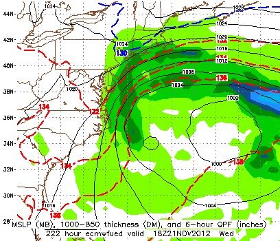
I like this thinking of the latest Euro just out...
Again, off the coast of North Carolina and OTS which has been the consistant part of all this and I believe that... HOWEVER...
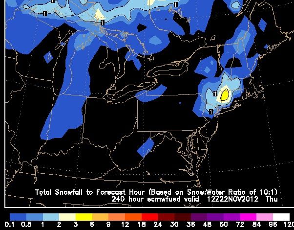
Now The Euro pulls the storm back into Maine and phases with the trough and another storm back to back which results in 6-10" of snow for Vermont, northern NY and New Hampshire.
That kind of setup I do believe in... And it happens on Thanksgiving (22nd)..
Interesting from HPC! They are agreeing on a Strong 1036 High Pressure to the north which will allow room for another storm to move in. Hmmmm
BOTH OPERATIONALS REMAIN AT ODDS WITH THE PLACEMENT OF SPOT LOWS
AND SURFACE WAVES ALONG THE STRONG BAROCLINIC ZONE IN THE WESTERN
ATLANTIC. HOWEVER...BOTH ARE IN GOOD AGREEMENT WITH THE INCREASING
DEPTH AND STRENGTH OF THE SURFACE TO THE NORTH SO PLACEMENT OF THE
STATIONARY BOUNDARY IS NOT AN ISSUE ALONG THE EAST COAST. FOR DAY
5-7...HAVE INCLUDED A 1036MB CONTOUR FOR THE CENTER OF THE HIGH
WHICH REINFORCES THE STRONG ENELY GRADIENT AND WILL ALLOW ROOM FOR
ANOTHER SURFACE WAVE TO EMERGE ALONG THE FRONT BEYOND DAY 7.
KBOX makes it easier for me. Here's their discussion. They are going with the EURO since its been consistant and has a better track record.
keep in mind, the previous storm showed a heavy snow swath from the start, this hasnt until recently, so Im not confident in snow but other issues might arise and its possible snow might come into the picture.
LONG TERM /THURSDAY THROUGH TUESDAY/...
HIGHLIGHTS...
* MAINLY DRY NORTHEAST FLOW INTO THE WEEKEND EXCEPT PERHAPS SOME
DRIZZLE IN SOUTHEAST AREAS THURSDAY.
* MINOR COASTAL FLOODING POSSIBLE AT HIGH TIDE THURSDAY. * SIGNIFICANT COASTAL STORM POSSIBLE EARLY AND MIDDLE OF NEXT
WEEK...
DETAILS...
MODELS/CONFIDENCE...
12Z MODEL GUIDANCE IS IN GENERAL AGREEMENT UNTIL THE END OF THE
PERIOD AS DIFFERENCES CONTINUE IN REGARDS TO THE EVOLUTION OF A
COASTAL STORM EARLY NEXT WEEK. A STRONG HIGH PRESSURE SYSTEM WILL
BECOME CENTERED OVER QUEBEC AND NORTHERN NEW ENGLAND THROUGH THE
WEEKEND.
AN UPPER LEVEL LOW PRESSURE SYSTEM WILL BEGIN TO CUT OFF
OVER THE TENNESSEE VALLEY FRIDAY AND SOUTHEASTERN STATES SATURDAY.
AS SOUTHERN STREAM ENERGY REACHES THE SYSTEM LATE IN THE WEEKEND
IT IS LIKELY TO BECOME NEGATIVELY TILTED ALOFT AND FORM A SURFACE
LOW WELL OFF THE COAST OF THE CAROLINAS.
THE GFS AND ITS ENSEMBLES KEEP THE LOW FAR ENOUGH OFFSHORE THAT IT BARELY SIDESWIPES US. HOWEVER THIS IS BELIEVED TO BE AN OUTLIER SOLUTION AS THE
ECMWF REMAINS CONSISTENT AND VERY STRONG WITH A BIG IMPACT FOR NEW
ENGLAND.
THE CMC IS QUICKER BUT AGREEING WITH A DEEP LOW PRESSURE
SYSTEM CLOSER TO THE COAST.
NCEP HAS THE LOW CLOSEST TO US ON MONDAY
THEN OUT TO SEA BY TUE.
WE ARE PREFERRING THE ECMWF SOLUTION AT THIS
TIME GIVEN ITS PAST PERFORMANCE AND ITS CURRENT PERSISTENCE.
Please register to post and access all features of our very popular forum. It is free and quick. Over $68,000 in prizes has already been given out to active posters on our forum. Additional giveaways are planned.
Detailed information about all U.S. cities, counties, and zip codes on our site: City-data.com.

 Please register to participate in our discussions with 2 million other members - it's free and quick! Some forums can only be seen by registered members. After you create your account, you'll be able to customize options and access all our 15,000 new posts/day with fewer ads.