Welcome to City-Data.com Forum!
U.S. CitiesCity-Data Forum Index
Go Back   City-Data Forum > General Forums > Weather
 [Register]
Please register to participate in our discussions with 2 million other members - it's free and quick! Some forums can only be seen by registered members. After you create your account, you'll be able to customize options and access all our 15,000 new posts/day with fewer ads.
View detailed profile (Advanced) or search
site with Google Custom Search

Search Forums  (Advanced)
Reply Start New Thread
 
Old 12-04-2013, 05:35 AM
 
Location: Near the Coast SWCT
83,506 posts, read 75,260,686 times
Reputation: 16619

Advertisements

Many will be seeing Ice.
Many will be seeing snow
Many will be seeing Rain.

There's 3 different events in this time frame.

Anything relating to these waves of low pressures / storms please post in here. Forecasts, discussions, thoughts, OBS.

Lets start with Soundings from the latest GFS6z for Sunday evening.

Harrisburg on left, Danbury on right. Heavy ice for MDT in Harrisburg as well as other areas around. Look at the output of temps. Clearly shows the warming mid levels and the below freezing surface.

Points northward like Danbury on the right would be all snow because the warm air hasn't moved in yet but will in the next several hours.

Reply With Quote Quick reply to this message

 
Old 12-04-2013, 05:40 AM
 
Location: Near the Coast SWCT
83,506 posts, read 75,260,686 times
Reputation: 16619
As far as timing... It's impossible to mention such a large area so check your local forecasts. For my area it should go like this...

Thursday drizzle starts
Thursday night Light rain moves in
Friday raining, damp cold air rushing in
Friday night starts changing to snow. Light Accumulations expected Saturday morning
Dry Saturday night and Sunday
Sunday evening snow starts falling with accumulations
Sunday night warm air rises over top of cold air so snow changes to sleet and ice for early morning
Monday by lunch everything changes to rain
Mid Week Frigid air moves in with 1st season single digits possible

This thread includes the snow & ice for Texas and Oklahoma as well.

Here's the current watches and warnings. Those are winter storm warnings out for Oklahoma & Arkansas now.

Reply With Quote Quick reply to this message
 
Old 12-04-2013, 05:56 AM
 
Location: Ashburn, VA
2,794 posts, read 2,932,162 times
Reputation: 4914
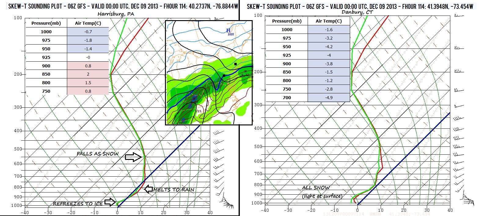
Just one big mixed bag of YUCK for my area....

Today Partly sunny, with a high near 51. Calm wind becoming southeast around 5 mph in the afternoon.
Tonight A chance of drizzle, then a chance of rain or drizzle after 11pm. Mostly cloudy, with a low around 40. East wind 3 to 5 mph. Chance of precipitation is 40%. New precipitation amounts of less than a tenth of an inch possible.
Thursday A chance of rain, mainly after 9am. Mostly cloudy, with a high near 60. Calm wind becoming southwest 5 to 7 mph in the afternoon. Chance of precipitation is 50%. New precipitation amounts of less than a tenth of an inch possible.
Thursday Night Rain likely. Cloudy, with a low around 47. Light and variable wind becoming west around 6 mph after midnight. Chance of precipitation is 70%. New precipitation amounts between a quarter and half of an inch possible.
Friday Rain likely. Cloudy, with a high near 52. North wind 7 to 10 mph. Chance of precipitation is 70%. New precipitation amounts between a tenth and quarter of an inch possible.
Friday Night Rain and sleet likely before 2am, then a chance of rain and snow between 2am and 4am, then a chance of snow after 4am. Cloudy, with a low around 32. Chance of precipitation is 60%. New precipitation amounts between a quarter and half of an inch possible.
Saturday Partly sunny, with a high near 41.
Saturday Night Partly cloudy, with a low around 23.
Sunday A chance of rain and snow. Mostly cloudy, with a high near 34. Chance of precipitation is 50%.
Sunday Night Rain, snow, freezing rain, and sleet likely. Cloudy, with a low around 32. Chance of precipitation is 60%.
Monday Rain or freezing rain likely. Cloudy, with a high near 45. Chance of precipitation is 60%.
Monday Night A chance of rain and snow. Mostly cloudy, with a low around 30. Chance of precipitation is 40%.
Tuesday A chance of rain. Partly sunny, with a high near 35. Chance of precipitation is 30%.

Reply With Quote Quick reply to this message
 
Old 12-04-2013, 05:58 AM
 
Location: Lincoln, NE
1,219 posts, read 1,507,776 times
Reputation: 566
Urgent - winter weather message
national weather service memphis tn
249 am cst wed dec 4 2013

...winter storm appearing more imminent in hitting a large
portion of the midsouth...

.ingredients are coming together better for a winter storm to hit
the midsouth starting late thursday evening across northeast
arkansas and the bootheel of missouri. Then as the cold air
slides southeast by friday morning winter precipitation will begin
affecting the mississippi delta counties...to include the memphis
metro...northeastward to the counties along the lower tennessee
river valley. A very cold shallow arctic airmass will slide into
the midsouth...while a prolonged warm and moist layer will ride
over top. This combination may generate significant amounts of
freezing rain...with some sleet and snow accumulations also
possible as the cold air becomes deeper entrenched over the area.
Midsoutherners are urged to take precautionary steps now in
preparation for hazardous winter weather. Stay tuned with the
forecast for the latest changes...to include potential warnings.

Arz049-058-msz001-007-tnz003-004-020-021-050>052-088-089-042200-
/o.new.kmeg.ws.a.0004.131206t1500z-131207t0300z/
lee ar-phillips-desoto-tunica-weakley-henry-gibson-carroll-
haywood-crockett-madison-shelby-fayette-
including the cities of...helena...southaven...olive branch...
Tunica...martin...dresden...paris...humboldt...mil an...
Huntingdon...jackson...bartlett...germantown...col lierville...
Memphis...millington...somerville
249 am cst wed dec 4 2013

...winter storm watch in effect from friday morning through
friday evening...

The national weather service in memphis has issued a winter storm
watch...which is in effect from friday morning through friday
evening.

* snow/sleet/ice accumulations...one quarter to one half of an
inch of ice accumulation. Less than one inch of snow and sleet
accumulation.

* timing...9 am friday morning through 9 pm friday evening.

* impacts...very hazardous travel. The potential for some down
tree branches and power lines...that may lead to scattered power
outages.

Precautionary/preparedness actions...

A winter storm watch means there is a potential for significant
snow...sleet...or ice accumulations that may impact travel.
Continue to monitor the latest forecasts.
Reply With Quote Quick reply to this message
 
Old 12-04-2013, 06:55 AM
 
Location: USA East Coast
4,429 posts, read 10,360,267 times
Reputation: 2157
I don't know how many places in the lower Midwest and esp the lower eastern USA (south of say 40 latitude) will see anything frozen in the next few day....temps look might warm. I think the frozen stuff will stay west of the Mississippi Valley at least till Saturday.


Reply With Quote Quick reply to this message
 
Old 12-04-2013, 07:01 AM
 
Location: Northville, MI
11,879 posts, read 14,202,675 times
Reputation: 6376
Snow initially predicted here with a high of 37 and low of 34 on December 8th. Next 2 days will constitute zero snowfall, only a possibility of heavy thunderstorms with highs in the mid 30's-low 40's F.

Accuweather has us in the 60's on December 4th & 9th. Going by their forecast, this could be one of the warmest Decembers ever, with highs around freezing next to impossible and almost zero chance of snowfall.

All other weather outlets are forecasting a normal December with some snowfall possible. Why does Accuweather forecast such absurd stuff.
Reply With Quote Quick reply to this message
 
Old 12-04-2013, 11:10 AM
 
Location: Near the Coast SWCT
83,506 posts, read 75,260,686 times
Reputation: 16619
Watches turned into Warnings for Oklahoma City and Tulsa. That's not a common thing before December 15th. Interesting pattern


Tulsa normally gets more than 1" snow after Jan 1st. OKC December 28th. OKC needs more than 3.9" of snow to get in Top 10 December snowfalls

Last edited by Cambium; 12-04-2013 at 11:27 AM..
Reply With Quote Quick reply to this message
 
Old 12-04-2013, 02:14 PM
 
Location: Near the Coast SWCT
83,506 posts, read 75,260,686 times
Reputation: 16619
Snowfall reports from Minnesota and neighboring states. http://www.crh.noaa.gov/mpx/?n=snowtotals


Duluth Minnesota here.
https://twitter.com/NewsBreaker/stat...36825564938240

Reply With Quote Quick reply to this message
 
Old 12-04-2013, 02:19 PM
 
Location: Near the Coast SWCT
83,506 posts, read 75,260,686 times
Reputation: 16619
Current radar, 1hr snowfall reports, Surface pressure & surface temps
Widespread Single digits in the afternoon and 60s in IL. Look at all that snow there.

Reply With Quote Quick reply to this message
 
Old 12-04-2013, 04:48 PM
 
Location: Near the Coast SWCT
83,506 posts, read 75,260,686 times
Reputation: 16619
Here's the Dallas forecast. 80° today to 20s and ice & snow.

http://forecast.weather.gov/MapClick.php?lat=32.8974493&lon=-97.04065330000003&site=all&smap=1&searchresult=Dal las%2FFort+Worth+International+Airport%2C+3200+Eas t+Airfield+Drive%2C+DFW+Airport%2C+TX+75261%2C+USA #.Up--NWUo7IU
Reply With Quote Quick reply to this message
Please register to post and access all features of our very popular forum. It is free and quick. Over $68,000 in prizes has already been given out to active posters on our forum. Additional giveaways are planned.

Detailed information about all U.S. cities, counties, and zip codes on our site: City-data.com.


Reply
Please update this thread with any new information or opinions. This open thread is still read by thousands of people, so we encourage all additional points of view.

Quick Reply
Message:


Over $104,000 in prizes was already given out to active posters on our forum and additional giveaways are planned!

Go Back   City-Data Forum > General Forums > Weather

All times are GMT -6.

© 2005-2024, Advameg, Inc. · Please obey Forum Rules · Terms of Use and Privacy Policy · Bug Bounty

City-Data.com - Contact Us - Archive 1, 2, 3, 4, 5, 6, 7, 8, 9, 10, 11, 12, 13, 14, 15, 16, 17, 18, 19, 20, 21, 22, 23, 24, 25, 26, 27, 28, 29, 30, 31, 32, 33, 34, 35, 36, 37 - Top