Please register to participate in our discussions with 2 million other members - it's free and quick! Some forums can only be seen by registered members. After you create your account, you'll be able to customize options and access all our 15,000 new posts/day with fewer ads.
It'll be interesting to see the impact this winter has on the drought. Hopefully some substantial improvement.
Don't worry, we could have 10x the amount of snowpack and rain we normally do and the media will always say "But this will do little to help the drought" and then go on to explain more doom and gloom and how California is screwed no matter what.
My thinking is that this is a blip in the overall California dry future. Dont want to sound like an alarmist but just what if California and the West are back into the 100-200yr drought patterns? (It has happened before) and these past couple months have only been a very tiny anomaly vs the overal scope!? Nobody knows so its just another BS thought and prediction just like global temps,sea levels, and anything relating to the future. Lol
My thinking is that this is a blip in the overall California dry future. Dont want to sound like an alarmist but just what if California and the West are back into the 100-200yr drought patterns? (It has happened before) and these past couple months have only been a very tiny anomaly vs the overal scope!? Nobody knows so its just another BS thought and prediction just like global temps,sea levels, and anything relating to the future. Lol
But what if?
That's possible. Still interesting in the short term to see decent precipitation though.
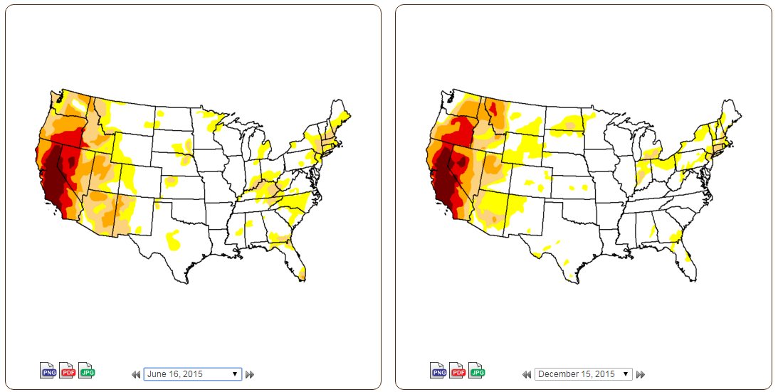
Coastal PNW is out of a drought. Some very subtle improvements in CA, but still a long way to go. Should be interesting to see what role the snowpack plays in the upcoming months:
AFTER A BREAK IN THE RAIN AND SNOW TONIGHT... ANOTHER WINTER
STORM WILL SPREAD OVER NORTHERN CALIFORNIA SUNDAY AND MONDAY.
LOWER SNOW LEVELS ARE EXPECTED WITH THIS SYSTEM AND AS A
RESULT...HIGHER ELEVATIONS WEST OF THE SACRAMENTO VALLEY ARE
LIKELY TO SEE SOME SIGNIFICANT SNOWFALL. OVER THE SIERRA SNOW
LEVELS WILL START OUT AROUND 3500 FEET...BUT RISE TO 5000 FEET
MONDAY MORNING AND ABOVE 6000 FEET MONDAY NIGHT.
SNOW ACCUMULATIONS...3 TO 6 INCHES WILL BE POSSIBLE ABOVE 2000
FEET.
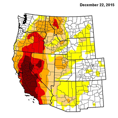
Compared to 3 months ago, big improvement up North, with some minor improvements in NorCal. Time will tell what relief CA will get in the coming months:
Please register to post and access all features of our very popular forum. It is free and quick. Over $68,000 in prizes has already been given out to active posters on our forum. Additional giveaways are planned.
Detailed information about all U.S. cities, counties, and zip codes on our site: City-data.com.

 Please register to participate in our discussions with 2 million other members - it's free and quick! Some forums can only be seen by registered members. After you create your account, you'll be able to customize options and access all our 15,000 new posts/day with fewer ads.