Please register to participate in our discussions with 2 million other members - it's free and quick! Some forums can only be seen by registered members. After you create your account, you'll be able to customize options and access all our 15,000 new posts/day with fewer ads.
Pretty amazing agreement on all models that there will be a prolonged period of snow in the Northeast from Northern Mid Atlantic to New England.
GFS & Euro starts it Saturday evening ends it Tuesday morning.
Canadian has the storm develop south more on Tuesday so it would end Wednesday morning
I have the end date on the thread as the 11th in case the Canadian model is right and we go into Wednesday with snow continuing. Will have mods adjust accordingly as we get closer.
--------------------
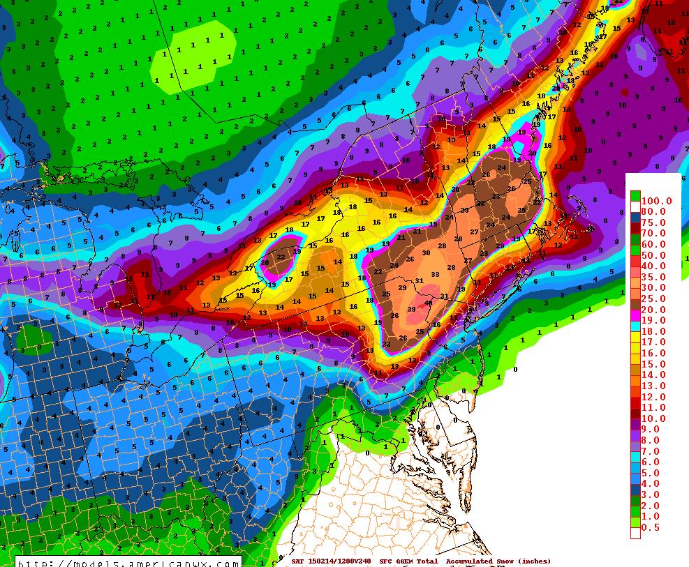
Basically, it's all going to come down to where this Polar front stalls. North of it all snow. Under it mix stuff. South of it all rain. Will it be south of NJ? North of NYC?
Here's what the Euro says for Monday morning.. North of blue line is snow. Darker greens would be moderate snows.
Some discussion tid bits from around.. It's all going to be about the front and the storm. NWS Philly says near or south of them which means it will be south of NYC which means NYC north could be all snow.
NWS NYNY
Quote:
NATIONAL WEATHER SERVICE NEW YORK NY
411 PM EST WED FEB 4 2015
SATURDAY NIGHT THROUGH MONDAY NIGHT...THE LATEST FORECAST GUIDANCE
CONTINUES TO SHOW AN ARCTIC FRONTAL BOUNDARY MOVING SOUTH OF THE AREA PUSHED BY A BUILDING AREA OF HIGH PRESSURE MOVING EAST
SOUTHEAST ACROSS THE GREAT LAKES. OVER RUNNING PRECIPITATION IS EXPECTED TO DEVELOP ALONG THIS FRONT SATURDAY NIGHT AND CONTINUE THROUGH TUESDAY...WITHLOW PRESSURE PASSING SOUTH OF LONG ISLAND MONDAY AND MONDAY NIGHT.
THE FORECAST LIQUID EQUIVALENT RANGES BETWEEN AN INCH AND AN INCH AND A QUARTER...MAINLY IN THE FORM OF SNOW.
AGAIN THERE DO REMAIN A FEW UNCERTAINTIES IN THE FORECAST...
IF THE HIGH IS STRONGER THAN FORECAST...IT WILL PUSH THE ARCTIC BOUNDARY TOO FAR SOUTH LEADING TO LESS OR NO SNOW.
IF THE HIGH IS WEAKER THAN FORECAST...THE LOW WILL TRACK FURTHER NORTHER BRINGING WARMER ALOFT WITH A POSSIBLE CHANGE IN THE PRECIPITATION TYPE FROM SNOW TO FREEZING RAIN / SLEET / OR JUST PLAIN RAIN.
THE PRECIPITATION COMES TO AN END ON TUESDAY WITH DRIER WEATHER
MOVING INTO THE REGION FOR TUESDAY NIGHT AND WEDNESDAY.
TEMPERATURES WILL REMAIN AT OR BELOW NORMAL THROUGH THE LONG TERM
PERIOD.
NWS Philly
Quote:
NATIONAL WEATHER SERVICE MOUNT HOLLY NJ
613 PM EST WED FEB 4 2015
.SYNOPSIS... A FRONTAL BOUNDARY WILL MOVE ACROSS THE AREA SATURDAY NIGHT AND STALL NEAR OR JUST SOUTH OF THE AREA SUNDAY INTO MONDAY. AN AREA
OF LOW PRESSURE IS EXPECTED TO DEVELOP ALONG THE BOUNDARY OVER THE
WEEKEND AND MOVE OFF THE MID ATLANTIC COAST AROUND MONDAY. THIS
LOW WILL TRACK TO OUR EAST THROUGH TUESDAY AS HIGH PRESSURE BUILDS
TO OUR WEST.
PTYPES ARE
STILL UNCERTAIN FOR A GOOD PORTION OF THE AREA, AS THE TRACK OF
THE LOW, AND HOW FAR SOUTH THE FRONT PUSHES, IF IT LIFTS NORTH AT
ALL, WILL ALL HELP DETERMINE WHERE ANY TRANSITION ZONE WILL
DEVELOP. IT STILL LOOKS LIKE THE NORTHERN THIRD OF THE AREA WILL
SEE ALL SNOW, WHILE FAR SOUTHERN AREAS MAY SEE ALL RAIN OR A
MAJORITY OF RAIN, WITH AREAS IN BETWEEN SOME SORT OF WINTRY MIX OF
SNOW, SLEET, RAIN, AND/OR POSSIBLE FREEZING RAIN. WE`VE INTRODUCED
SLEET INTO THE FORECAST, AND WILL SEE IN FUTURE FORECASTS IF
FREEZING RAIN BECOMES MORE OF A THREAT.
Scary that all 3 main models are showing 10"+ next 10 days.
Bridgeports normal snow total for February is 8.1".
They have 10 inches already. LOL 20th snowiest February on record.
If another 12" falls this month it will be the 6th snowiest Feb on record
NErn/ Central mass has 36-40 inches of snow on the ground +20-25 inches I don't know how cities like Lowell/Leominster/Worcester can deal with a 60 inch snow pack
Please register to post and access all features of our very popular forum. It is free and quick. Over $68,000 in prizes has already been given out to active posters on our forum. Additional giveaways are planned.
Detailed information about all U.S. cities, counties, and zip codes on our site: City-data.com.

 Please register to participate in our discussions with 2 million other members - it's free and quick! Some forums can only be seen by registered members. After you create your account, you'll be able to customize options and access all our 15,000 new posts/day with fewer ads.