Please register to participate in our discussions with 2 million other members - it's free and quick! Some forums can only be seen by registered members. After you create your account, you'll be able to customize options and access all our 15,000 new posts/day with fewer ads.
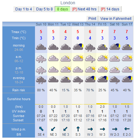
A UV of 4 on 10th February, sun all day plus 24 inches of snow on the ground?! I have just got dry and changed my clothes from getting drenched cycling home from church, and the rain still lashes down outside my window as it will all day - can I come over and visit your place?
A UV of 4 on 10th February, sun all day plus 24 inches of snow on the ground?! I have just got dry and changed my clothes from getting drenched cycling home from church, and the rain still lashes down outside my window as it will all day - can I come over and visit your place?
THE NATIONAL WEATHER SERVICE IN TAUNTON HAS ISSUED A WINTER
WEATHER ADVISORY FOR SNOW SLEET AND FREEZING RAIN|...WHICH IS IN
EFFECT FROM 6 AM TO 1 PM EST MONDAY.
* LOCATIONS...NORTHERN INTERIOR MASSACHUSETTS AND SOUTHWEST NEW
HAMPSHIRE.
* HAZARD TYPES...SNOW SLEET AND FREEZING RAIN.
* ACCUMULATIONS...SNOW ACCUMULATION OF 1 TO 2 INCHES...ALONG WITH
UP TO A TENTH OF AN INCH OF AN ICE.
* TIMING...SNOW SLEET AND FREEZING RAIN DEVELOPING AFTER 6
AM...THEN CHANGING TO RAIN BETWEEN 10 AM AND 1 PM.
* IMPACTS...THE COMBINATION OF SNOW AND ICE WILL MAKE UNTREATED
ROADS SLIPPERY.
This Afternoon A chance of rain. Cloudy, with a high near 41. Southeast wind around 10 mph. Chance of precipitation is 40%.
Tonight Rain, mainly before 3am, then areas of drizzle. Temperature rising to around 41 by 11pm. Breezy, with a south southeast wind 14 to 18 mph, with gusts as high as 24 mph. Chance of precipitation is 100%. New precipitation amounts between a tenth and quarter of an inch possible.
Monday Areas of drizzle before 11am. Cloudy, with a high near 40. Windy, with a west southwest wind 16 to 21 mph increasing to 25 to 30 mph in the afternoon. Winds could gust as high as 46 mph.
Monday Night A chance of snow showers. Mostly cloudy, with a low around 27. Windy, with a west wind 21 to 26 mph decreasing to 13 to 18 mph after midnight. Winds could gust as high as 41 mph. Chance of precipitation is 40%
Tuesday Mostly cloudy, with a high near 35. West northwest wind 10 to 14 mph, with gusts as high as 22 mph.
This I can handle. At least it's not getting ridiculously warm.
Tonight: A chance of freezing rain after 5am. Increasing clouds, with a low around -6. Calm wind. Chance of precipitation is 30%.
Monday: Periods of rain or freezing rain, becoming all rain after 4pm. Patchy fog before 2pm. High near 5. Southeast wind 5 to 13 km/h becoming southwest in the afternoon. Chance of precipitation is 100%. New ice accumulation of less than a 0.1 of a centimeter possible.
Monday Night: A chance of rain, mainly before 7pm. Cloudy, then gradually becoming partly cloudy, with a low around -1. Southwest wind 5 to 11 km/h. Chance of precipitation is 30%.
Tuesday: Mostly cloudy, with a high near 5. Southwest wind 11 to 21 km/h.
Tuesday Night: Partly cloudy, with a low around -7. West wind 8 to 13 km/h becoming light after midnight.
Wednesday: Sunny, with a high near 4.
Wednesday Night: A chance of snow after 2am. Mostly cloudy, with a low around -4. Chance of precipitation is 30%.
Thursday: Partly sunny, with a high near 7.
Thursday Night: A chance of snow showers. Mostly cloudy, with a low around -4. Chance of precipitation is 30%.
Friday: A chance of snow showers. Partly sunny, with a high near 4. Chance of precipitation is 30%.
Friday Night: A chance of snow. Mostly cloudy, with a low around -3. Chance of precipitation is 30%.
Saturday: A chance of snow. Mostly cloudy, with a high near 1. Chance of precipitation is 50%.
Saturday Night: A chance of snow. Mostly cloudy, with a low around -6. Chance of precipitation is 50%.
Sunday: A chance of snow showers. Partly sunny, with a high near -2. Chance of precipitation is 40%.
Tonight: Snow, mainly before 2am. Low around -4. Southeast wind 5 to 8 km/h becoming north after midnight. Chance of precipitation is 80%. New snow accumulation of 2 to 4 centimeters possible.
Thursday: Mostly sunny, with a high near 6. Northwest wind 8 to 10 km/h becoming southwest in the afternoon.
Thursday Night: Mostly cloudy, with a low around -3. South wind 5 to 8 km/h.
Friday: A slight chance of snow showers before 10am, then a slight chance of rain showers. Partly sunny, with a high near 9. Southwest wind 8 to 13 km/h increasing to 18 to 23 km/h in the afternoon. Chance of precipitation is 20%.
Friday Night: A slight chance of rain showers before 10pm, then a slight chance of snow showers. Mostly cloudy, with a low around -5. Chance of precipitation is 20%.
Saturday: Mostly cloudy, with a high near 1.
Saturday Night: Mostly cloudy, with a low around -9.
Sunday: Mostly sunny, with a high near -3. Blustery.
Sunday Night: Partly cloudy, with a low around -10.
Washington's Birthday: Mostly sunny, with a high near 2.
Monday Night: Partly cloudy, with a low around -6.
Tuesday: A chance of showers. Mostly cloudy, with a high near 6. Chance of precipitation is 40%.
Tuesday Night: A chance of snow. Mostly cloudy, with a low around -4. Chance of precipitation is 50%.
Wednesday: Partly sunny, with a high near 1. Breezy.
Stillwater Weather Forecast - Outlook This Afternoon & Tonight This
Afternoon
Sunny
Hi 50 °FNWS forecast: Sunny, with a high near 50. Southwest wind around 10 mph. Tonight
Partly
Cloudy
Lo 29 °FNWS forecast: Partly cloudy, with a low around 29. Southwest wind 5 to 9 mph. Short Term Weather Forecast For Stillwater Thursday
Increasing
Clouds
Hi 54 °F Thursday
Night
Mostly
Cloudy
Lo 28 °F Friday
Mostly
Sunny
Hi 44 °F Friday
Night
Flurries
Lo 27 °F Saturday
Mostly
Sunny
Hi 49 °F Saturday
Night
Mostly
Clear
Lo 30 °F Sunday
Looks like a glaring day for the big paddle tomorrow -some cloud would be nice.
Please register to post and access all features of our very popular forum. It is free and quick. Over $68,000 in prizes has already been given out to active posters on our forum. Additional giveaways are planned.
Detailed information about all U.S. cities, counties, and zip codes on our site: City-data.com.

 Please register to participate in our discussions with 2 million other members - it's free and quick! Some forums can only be seen by registered members. After you create your account, you'll be able to customize options and access all our 15,000 new posts/day with fewer ads.