Please register to participate in our discussions with 2 million other members - it's free and quick! Some forums can only be seen by registered members. After you create your account, you'll be able to customize options and access all our 15,000 new posts/day with fewer ads.
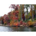
Planning a mini trip. When is the best time to see the leaves, end of Oct or Nov? And, is there a festival in the fall on a weekend that you would recommend?
Another incredible event, weekend of October 5th, if you have the time (about 1.5 hrs. each way) for a day trip:
If you decide to go, be sure to attend the music events which you will get you toe-tapping and singing all the way home. Children and teens also will like it; they have some farm animals there, alpacas, sheep, etc. and yarn spinning exhibits. Plenty of food vendors as well.
Due to portions of parkway closure, here a list of different scenic routes
Quote:
Originally Posted by SunnyKayak
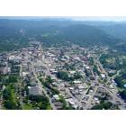
Central to Lower NC Appalachians
Black Mountain Rag Length: 31 miles Drive Time: 45 minutes
The route follows State Highway 9 to Bat Cave, then forks. Drivers can opt to take US 64 southeasterly past Hickory Nut Gorge and Chimney Rock State Park to Lake Lure, or travel in a southwesterly direction on US 64 west to the apple orchards of Edneyville.
Drovers Road Length: 16.5 miles Drive Time: 25 minutes
It takes travelers through the scenic Hickory Nut Gorge, near Chimney Rock State Park and Lake Lure.
French Broad Overview Length: 17 miles Drive Time: 25 minutes
From Weaverville, to Alexander and then north on US 251 to just past Marshall, this Scenic Byway winds through rolling hills and peaceful farmland along the French Broad River.
Historic Flat Rock Scenic BywayLength: 8.3 miles Drive Time: 20 minutes
Consists of several roads in the Flat Rock community, near Hendersonville. The village was a popular haven for affluent Charlestonians, Europeans and plantation owners.
The eight-mile byway leads past many beautiful historic homes, the St. John in the Wilderness gothic revival church, the Flat Rock Playhouse, the Historic Woodfield Inn, and the Carl Sandburg Home historic site.
Pacolet River BywayLength: 10 miles Drive Time: 20 minutes
Runs along US 176 between Tryon and Saluda, in the southwestern part of North Carolina.
Includies passing old railroad depots, log cabins, and the Saluda Grade, the steepest mainline railroad grade in the country and Pearson's Falls.
Forest Heritage Scenic BywayLength: 65 miles Drive Time: 2 hours Will pass beautiful mountain scenery and waterfalls and have the opportunity to stop in Brevard and at the Cradle of Forestry
Follows State Highway 276 northward out of Brevard to Woodrow, then turns south again on State Highway 215 to Rosman.
NC folk are the nicest and not all FL folk are rude. ha
Please register to post and access all features of our very popular forum. It is free and quick. Over $68,000 in prizes has already been given out to active posters on our forum. Additional giveaways are planned.
Detailed information about all U.S. cities, counties, and zip codes on our site: City-data.com.

 Please register to participate in our discussions with 2 million other members - it's free and quick! Some forums can only be seen by registered members. After you create your account, you'll be able to customize options and access all our 15,000 new posts/day with fewer ads.