Please register to participate in our discussions with 2 million other members - it's free and quick! Some forums can only be seen by registered members. After you create your account, you'll be able to customize options and access all our 15,000 new posts/day with fewer ads.
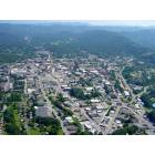
Asheville surprised me by how mountainous it is, curious if Brevard is the same?
I'm surprised you were surprised! Turn the "terrain" feature on in google maps. It's under the menu (3 lines icon next to the search box). Asheville is not even that mountainous compared to other places in the mountains like Boone and Blowing Rock, Cullowhee, Maggie Valley, or Waynesville. Brevard is probably a little moreso than Asheville, but of course it depends on where you are in either town.
Where in town is the 2134 elevation (just curious since it varies significantly within city limits). The airport is 2165 and my residence is at 2158. Pack Square is 2231. Going back to the OP, though...Brevard does have considerably more precip than Asheville and a bit less snowfall as it's slightly warmer in the winter.
Where in town is the 2134 elevation (just curious since it varies significantly within city limits). The airport is 2165 and my residence is at 2158. Pack Square is 2231. Going back to the OP, though...Brevard does have considerably more precip than Asheville and a bit less snowfall as it's slightly warmer in the winter.
Hi zoo
used the official city data elevation numbers and linked to the pages for OPS own research. Pictures on the city pages often tell the story too.
To the OP
Hope you enjoy your trip. check out romanticasheville for activities. But other than parking/staying downtown and walking around the shops and restaurants; for the most part you have to drive where you want to go (e.g. skinny dipping falls, Blue Ridge Parkway).
My personal favorite is Mount Mitchell State park. The first time there when I was 17 days old and it has been the go to place for both sides of my family to meet for picnics and hikes.
We used to visit my cousins who lived in MN and I remember it fondly. It is different than WNC but nice.
Fwiw, Wiki lists 'Brevard' at 2231...no idea where that elevation was recorded.
Wiki also lists Waynesville at "2752", but much of Waynesville is ringed by 5-6000+ ft peaks, and has considerable population at elevations of 3,000 to 4,000 ft elevation.
GL, mD
Brevard is located within a temperate rain forest, and the plateau that the Asheville airport sits on and the surrounding area gets the least rain in Weatern NC.
Brevard is located within a temperate rain forest, and the plateau that the Asheville airport sits on and the surrounding area gets the least rain in Weatern NC.
Downtown is even drier than the airport. It's just more of a pain to get the observations taken at the federal building.
Please register to post and access all features of our very popular forum. It is free and quick. Over $68,000 in prizes has already been given out to active posters on our forum. Additional giveaways are planned.
Detailed information about all U.S. cities, counties, and zip codes on our site: City-data.com.

 Please register to participate in our discussions with 2 million other members - it's free and quick! Some forums can only be seen by registered members. After you create your account, you'll be able to customize options and access all our 15,000 new posts/day with fewer ads.