Please register to participate in our discussions with 2 million other members - it's free and quick! Some forums can only be seen by registered members. After you create your account, you'll be able to customize options and access all our 15,000 new posts/day with fewer ads.
Red Flag Warning, Western Half of the State, 8-10-12
Urgent - fire weather message
national weather service billings mt
115 pm mdt fri aug 10 2012
mtz124>131-wyz274-284-110600-
/o.con.kbyz.fw.w.0017.000000t0000z-120811t0600z/
wheatland county/sweet grass county-stillwater county-
beartooth ranger district custer national forest-
golden valley county/musselshell county-yellowstone county-
crow indian reservation/big horn canyon rec area-
northern rosebud/northern treasure counties-
northern cheyenne indian reservation/ashland ranger district
custer natl forest-sheridan county-big horn national forest-
115 pm mdt fri aug 10 2012
...red flag warning remains in effect until midnight mdt tonight
for increasing thunderstorm activity for most of south central
montana...parts of southeast montana...and parts of north central
wyoming...
* affected area...in montana...fire zones...124...125...126...127
128...129...130...131
in wyoming...fire zones...274...284
* impacts...critical fire weather conditions will develop this
afternoon and evening due to increased thunderstorm activity and
the potential for frequent lightning and strong erratic wind
gusts.
* wind...gusts of 40 to 50 mph are possible near thunderstorms.
* rainfall...thunderstorms will be wet and may produce moderate
to heavy rainfall.
Precautionary/preparedness actions...
A red flag warning means that critical fire weather conditions are
either occurring now...or will shortly. A combination of strong
winds...low relative humidity...and warm temperatures will create
explosive fire growth potential.
Severe Thunderstorm Warning, Mule Creek Junction, 8-10-12
Severe thunderstorm warning
wyc009-027-110045-
/o.new.kcys.sv.w.0083.120810t2339z-120811t0045z/
bulletin - immediate broadcast requested
severe thunderstorm warning
national weather service cheyenne wy
539 pm mdt fri aug 10 2012
the national weather service in cheyenne has issued a
* severe thunderstorm warning for...
East central converse county in east central wyoming...
Northern niobrara county in east central wyoming...
* until 645 pm mdt
* at 537 pm mdt...national weather service doppler radar indicated a
severe thunderstorm capable of producing quarter size hail...and
destructive winds in excess of 70 mph. This storm was located 12
miles east of bill...or 34 miles northeast of douglas...and moving
east at 10 mph.
* locations impacted include...
Redbird and mule creek junction.
Precautionary/preparedness actions...
If you are in the path of this storm...prepare immediately for large
hail and damaging winds. People outside should move to a shelter...
Preferably inside a strong building and away from windows.
Red Flag Warning, Conflicting reports, please read, 8-28-2012
I am getting two conflicting reports this morning. One report says almost the entire state is covered by Red Flag Fire Danger and the other report says only the North East quarter of the state. At any rate, we are expected to have near record high temps, most everywhere. So please be careful and report anything you see. We can't be too careful when it comes to fire danger.
URGENT - FIRE WEATHER MESSAGE
NATIONAL WEATHER SERVICE BILLINGS MT
405 AM MDT TUE AUG 28 2012
MTZ123>133-WYZ274-284-282230-
/O.UPG.KBYZ.FW.A.0014.120828T1800Z-120830T0600Z/
/O.NEW.KBYZ.FW.W.0021.120828T1800Z-120830T0600Z/
GALLATIN NATIONAL FOREST-WHEATLAND COUNTY/SWEET GRASS COUNTY-
STILLWATER COUNTY-BEARTOOTH RANGER DISTRICT CUSTER NATIONAL FOREST-
GOLDEN VALLEY COUNTY/MUSSELSHELL COUNTY-YELLOWSTONE COUNTY-
CROW INDIAN RESERVATION/BIG HORN CANYON REC AREA-
NORTHERN ROSEBUD/NORTHERN TREASURE COUNTIES-
NORTHERN CHEYENNE INDIAN RESERVATION/ASHLAND RANGER DISTRICT
CUSTER NATL FOREST-CUSTER COUNTY-
SIOUX RANGER DISTRICT CUSTER NATIONAL FOREST-SHERIDAN COUNTY-
BIG HORN NATIONAL FOREST-
405 AM MDT TUE AUG 28 2012
...RED FLAG WARNING IN EFFECT FROM NOON TODAY TO MIDNIGHT MDT
WEDNESDAY NIGHT FOR LOW HUMIDITIES...HOT TEMPERATURES...STRONG
GUSTY WINDS...AND WIND SHIFT WITH A COLD FRONT FOR ALL OF SOUTH
CENTRAL MONTANA...ALL OF SOUTHEAST MONTANA...PARTS OF NORTHWEST
SOUTH DAKOTA...AND PARTS OF NORTH CENTRAL WYOMING...
THE NATIONAL WEATHER SERVICE IN BILLINGS HAS ISSUED A RED FLAG
WARNING...WHICH IS IN EFFECT FROM NOON TODAY TO MIDNIGHT MDT
WEDNESDAY NIGHT.
* AFFECTED AREA...IN MONTANA...FIRE ZONES...123...124...125...126
127...128...129...130
131...132...133
IN WYOMING...FIRE ZONES...274...284
* IMPACTS...A COMBINATION OF VERY LOW HUMIDITIES...NEAR RECORD
TEMPERATURES AND BRISK WINDS WILL CAUSE EXTREMELY DANGEROUS FIRE
WEATHER CONDITIONS. NEW OR EXISTING FIRE COULD GROW AND SPREAD
RAPIDLY.
* COLD FRONT...THE FRONT IS EXPECTED TO MOVE INTO THE REGION FROM
THE NORTHWEST BY EARLY WEDNESDAY EVENING...AND ACROSS MOST OF
THE WARNED AREA BY MIDNIGHT.
* WIND...WEST TO SOUTHWEST WINDS FROM 5 TO 15 MPH WILL BE COMMON
TODAY. WIND WILL BECOME 15 TO 30 MPH WEDNESDAY AHEAD OF THE COLD
FRONT. WINDS WILL SHIFT TO THE NORTH BEHIND THE FRONT WEDNESDAY
EVENING WITH GUSTS FROM 40 TO 45 MPH POSSIBLE.
* HUMIDITY...AFTERNOON READINGS WILL RANGE FROM 5 TO 12 PERCENT.
OVERNIGHT RECOVERIES WILL BE QUITE POOR AS WELL.
PRECAUTIONARY/PREPAREDNESS ACTIONS...
A RED FLAG WARNING MEANS THAT CRITICAL FIRE WEATHER CONDITIONS ARE
EXPECTED TO OCCUR. A COMBINATION OF STRONG WIND...VERY LOW
RELATIVE HUMIDITY...AND NEAR RECORD TEMPERATURES WILL CREATE
EXPLOSIVE FIRE GROWTH POTENTIAL.
Urgent - fire weather message
national weather service rapid city sd
358 am mdt sun sep 9 2012
...red flag warning in effect on sunday for low relative humidity and
gusty winds for the northeast wyoming plains...the black
hills...and far western south dakota...
...fire weather watch in effect from monday morning through
monday evening for low relative humidity and gusty winds for the
northeast wyoming plains...the black hills...and all of western
south dakota...
.very low humidity and gusty winds will be found across the area
today and monday.
For today...gusty south winds will develop across northeast
wyoming and far western south dakota...with 15 to 30 mph winds.
Minimum relative humidity sunday afternoon will range from around
8 percent in northeast wyoming to around 15 percent in western
south dakota. Locally gusty winds will persist into monday across
northeast wyoming and western south dakota. Relative humidity
recovery will be poor tonight across northeast wyoming and
western south dakota...with the maximum relative humidity reaching
30 to 45 percent.
Temperatures will be hot on monday...with highs in the 90s to
around 100 degrees. The minimum relative humidity on monday will
range from 7 to 15 percent...with gusty southwest winds. A strong
cold front will slide through the area late monday night with
winds shifting to the northwest and gusting over 40 mph. Isolated
thunderstorms are possible monday evening across northeast
wyoming and western south dakota. Gusty winds and very little rain
is expected with the thunderstorms.
Sdz260>264-wyz259-297>299-091800-
/o.con.kunr.fw.w.0030.120909t1600z-120910t0300z/
/o.con.kunr.fw.a.0027.120910t1500z-120912t0300z/
northern black hills-northwestern south dakota plains-
southern black hills-southwestern south dakota-badlands area-
southern campbell-northern campbell-
lower elevations of crook and weston counties-wyoming black hills-
358 am mdt sun sep 9 2012
...red flag warning remains in effect from 10 am this morning to
9 pm mdt this evening for low relative humidity and gusty winds
for northeast wyoming...the black hills...and far western south
dakota...
...fire weather watch remains in effect from monday morning
through tuesday evening for low relative humidity and gusty winds
for the northeast wyoming plains...the black hills...and all of
western south dakota...
* affected area...fire weather zone 259 southern campbell...fire
weather zone 260 northern black hills...fire weather zone 261
northwestern south dakota plains...fire weather zone 262
southern black hills...fire weather zone 263 southwestern
south dakota...fire weather zone 264 badlands area...fire
weather zone 297 northern campbell...fire weather zone 298
lower elevations of crook and weston counties and fire weather
zone 299 wyoming black hills.
* winds...south winds 15 to 30 mph today. Southwest winds 15 to 25
mph tonight and monday. Winds becoming northwest 15 to 30 mph
monday night with gusts over 40 mph.
* relative humidity...minimum relative humidity 7 to 15 percent
today and monday. Maximum relative humidity tonight 30 to 45
percent.
* temperatures...highs in the mid 80s to lower 90s today. Highs in
the upper 80s to around 100 on monday
* lightning...isolated thunderstorms possible monday evening with
very little rainfall.
* impacts...rapid and large fire growth could occur.
Precautionary/preparedness actions...
A fire weather watch means that critical fire weather conditions
are forecast to occur. Listen for later forecasts and possible
red flag warnings.
A red flag warning means that critical fire weather conditions
are either occurring now...or will shortly. A combination of
strong winds...low relative humidity...and warm temperatures will
create explosive fire growth potential.
Normal First Frost ...September 11
Earliest Frost ...July 2
Normal First Freeze ....September 20
Earliest Freeze ....August 17
Normal First Hard Freeze ....October 3
Earliest Hard Freeze....August 25
Frost based on 36° F
Freeze based on 32° F
Hard Freeze based on 28° F
Ranchester, NOAA station This year only
First Frost..... August 4
First Freeze..... September 5
First Hard Freeze..... September 12
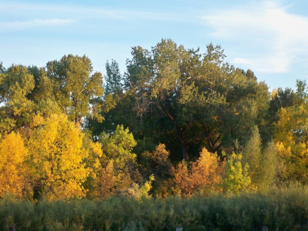
Does it show? This was taken from my porch, a couple days ago.
Sep 17: On this day in 2000 Cheyenne reached a high of 91 degrees, which is the latest
day in history that Cheyenne reached at least 90 degrees. Conversely, on this
day in 1965, Cheyenne only reached a high of 31 degrees, the earliest day in
fall that Cheyenne has remained below freezing.
Today is the average first freeze date in fall for Rawlins, Wyoming.
Sep 18: The greatest daily precipitation amount ever recorded in Chadron, Nebraska
occurred on this day in 1986 when 4.40 inches of rain flooded the area.
Cheyenne recorded a 4.0 inch snowfall on this day in 1942.
Sep 19: An early season winter storm began across portions of east-central Wyoming
and the northern Nebraska panhandle on this day in 1995. 1 to 4 inches of snow
was recorded by the end of the day with the snow continuing into the 20th.
Sep 20: The 1995 winter storm ended after producing 2 to 8 inches of snow. Some
power outages occurred due to heavy snow breaking tree branches onto power
lines.
Today is the average first freeze date in fall over parts of the northern Nebraska
panhandle including Harrison.
Sep 21: Two and a half inches of snow was recorded in Scottsbluff on this day in 1895.
Sep 22: The heaviest September snowstorm ever recorded in Cheyenne began on this
day in 2000. Just 1.2 inches of snow had fallen by the end of the day, but much
more was to come. Also on this day in 1979 Cheyenne was buffeted by strong
winds, with a peak gust of 74 mph.
Sep 23: The 2000 snowstorm dropped an additional 4.2 inches of snow on Cheyenne
on this day while Scottsbluff received 2.7 inches of snow.
Today has been the average first freeze date over the last 30 years in
Wheatland and Alliance.
Severe Thunderstorm Warning, Johnson County, 9-28-2012
Severe thunderstorm warning
wyc019-282215-
/o.new.kriw.sv.w.0024.120928t2120z-120928t2215z/
bulletin - immediate broadcast requested
severe thunderstorm warning
national weather service riverton wy
320 pm mdt fri sep 28 2012
the national weather service in riverton has issued a
* severe thunderstorm warning for...
East central johnson county in north central wyoming...
* until 415 pm mdt
* at 316 pm mdt...national weather service doppler radar indicated a
severe thunderstorm capable of producing half dollar size hail.
This storm was located 12 miles east of i25 exit 280...or 26 miles
northeast of kaycee...and moving southeast at 10 mph.
* the severe thunderstorm will be near...
Fort reno historical site around 415 pm mdt.
Precautionary/preparedness actions...
If you are in the path of this storm...prepare immediately for large
hail and deadly cloud to ground lightning. People outside should move
to a shelter...preferably inside a strong building and away from
windows.
&&
report severe weather to the national weather service office in
riverton at 1-800-211-1448.
Please register to post and access all features of our very popular forum. It is free and quick. Over $68,000 in prizes has already been given out to active posters on our forum. Additional giveaways are planned.
Detailed information about all U.S. cities, counties, and zip codes on our site: City-data.com.

 Please register to participate in our discussions with 2 million other members - it's free and quick! Some forums can only be seen by registered members. After you create your account, you'll be able to customize options and access all our 15,000 new posts/day with fewer ads.