Dalton, Massachusetts
Submit your own pictures of this town and show them to the world
- OSM Map
- General Map
- Google Map
- MSN Map
Population change since 2000: -2.0%
 |
| Males: 3,241 | |
| Females: 3,515 |
| Median resident age: | 44.7 years |
| Massachusetts median age: | 39.2 years |
Zip codes: 01226.
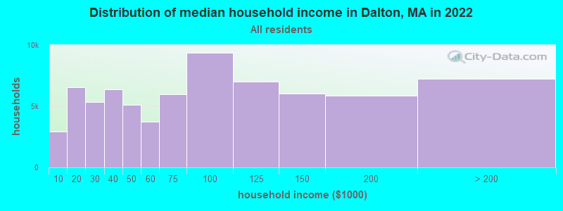
| Dalton: | $90,977 |
| MA: | $94,488 |
Estimated per capita income in 2022: $53,011 (it was $23,634 in 2000)
Dalton town income, earnings, and wages data
Estimated median house or condo value in 2022: $301,649 (it was $112,800 in 2000)
| Dalton: | $301,649 |
| MA: | $534,700 |
Mean prices in 2022: all housing units: $357,971; detached houses: $376,086; townhouses or other attached units: $341,816; in 2-unit structures: $250,940; in 3-to-4-unit structures: $400,871; in 5-or-more-unit structures: $281,990; mobile homes: $80,872
Detailed information about poverty and poor residents in Dalton, MA
Compare current foreclosures near Dalton, MA:
| Photo | Address | Area | Beds / Baths | Price | Details |
|---|---|---|---|---|---|

|
#1
Ashuelot St
Dalton, MA 01226
|
1,792 sq. feet
|
2 baths 3 beds |
show details | |

|
#2
North St
Dalton, MA 01226
|
1,852 sq. feet
|
2 baths 4 beds |
show details | |

|
#3
Elmwood Ave
North Adams, MA 01247
|
2,777 sq. feet
|
3 baths 5 beds |
$215,000
|
show details |

|
#4
Crystal St
Lenox Dale, MA 01242
|
1,918 sq. feet
|
2 baths 3 beds |
$165,900
|
show details |

|
#5
Washington Mountain Rd
Lee, MA 01238
|
- sq. feet
|
1 baths 3 beds |
$155,000
|
show details |

|
#6
Robbins Ave
Pittsfield, MA 01201
|
1,872 sq. feet
|
2 baths 4 beds |
show details | |

|
#7
Grove St
Adams, MA 01220
|
2,644 sq. feet
|
2 baths 7 beds |
show details | |

|
#8
Barbour St
North Adams, MA 01247
|
1,224 sq. feet
|
1 baths 2 beds |
show details | |

|
#9
Arnold Ct
Cheshire, MA 01225
|
1,600 sq. feet
|
2 baths 2 beds |
show details | |

|
#10
Houghton St
North Adams, MA 01247
|
1,614 sq. feet
|
2 baths 4 beds |
show details |
| Photo | Address | Area | Beds / Baths | Price | Details |
|---|---|---|---|---|---|

|
#11
Madison Ave
Pittsfield, MA 01201
|
2,192 sq. feet
|
2 baths 6 beds |
show details | |

|
#12
Tierney Pl
Pittsfield, MA 01201
|
1,103 sq. feet
|
1 baths 3 beds |
show details | |

|
#13
North St
Pittsfield, MA 01201
|
1,661 sq. feet
|
2 baths 4 beds |
show details | |

|
#14
Circular Ave
Pittsfield, MA 01201
|
2,808 sq. feet
|
4 baths 8 beds |
show details | |

|
#15
Daniels Ave
Pittsfield, MA 01201
|
3,040 sq. feet
|
3 baths 6 beds |
show details | |

|
#16
Wilshire Dr
Cheshire, MA 01225
|
4,302 sq. feet
|
2 baths 3 beds |
show details | |

|
#17
North St
North Adams, MA 01247
|
1,164 sq. feet
|
1 baths 3 beds |
show details | |

|
#18
Franklin St
North Adams, MA 01247
|
1,386 sq. feet
|
1 baths 3 beds |
show details | |

|
#19
Weller Ave
Pittsfield, MA 01201
|
3,376 sq. feet
|
3 baths 6 beds |
show details | |

|
#20
Richmond St
Adams, MA 01220
|
1,920 sq. feet
|
2 baths 4 beds |
show details |
| Photo | Address | Area | Beds / Baths | Price | Details |
|---|---|---|---|---|---|

|
#21
Linden St
Williamstown, MA 01267
|
2,298 sq. feet
|
3 baths 4 beds |
show details | |

|
#22
W Mountain Rd
Adams, MA 01220
|
1,173 sq. feet
|
1 baths 3 beds |
show details | |

|
#23
Phelps Rd
North Adams, MA 01247
|
1,286 sq. feet
|
1 baths 4 beds |
show details | |

|
#24
Imperial Ave
Pittsfield, MA 01201
|
1,326 sq. feet
|
1 baths 3 beds |
show details | |

|
#25
Daniels Ct
Adams, MA 01220
|
1,400 sq. feet
|
1 baths 3 beds |
show details | |

|
#26
Old North Rd
Worthington, MA 01098
|
2,369 sq. feet
|
3 baths 4 beds |
show details | |

|
#27
Garfield Ave
Pittsfield, MA 01201
|
2,432 sq. feet
|
2 baths 4 beds |
show details | |

|
#28
Weber St # 12
Adams, MA 01220
|
1,728 sq. feet
|
2 baths 4 beds |
show details | |

|
#29
North St
North Adams, MA 01247
|
1,164 sq. feet
|
1 baths 3 beds |
show details | |

|
#30
Morgan St
Lenox, MA 01240
|
3,959 sq. feet
|
2 baths 3 beds |
show details |
| Photo | Address | Area | Beds / Baths | Price | Details |
|---|---|---|---|---|---|

|
#31
Loop Rd
Savoy, MA 01256
|
1,040 sq. feet
|
1 baths 3 beds |
show details | |

|
#32
Valley St
Adams, MA 01220
|
1,680 sq. feet
|
2 baths 4 beds |
show details | |

|
#33
E Hoosac St
Adams, MA 01220
|
594 sq. feet
|
1 baths 2 beds |
show details | |

|
#34
Anthony St # B
Adams, MA 01220
|
1,622 sq. feet
|
2 baths 3 beds |
show details | |

|
#35
East St
Lee, MA 01238
|
1,478 sq. feet
|
2 baths 3 beds |
show details | |

|
#36
Grange Hall Rd
Stephentown, NY 12168
|
1,670 sq. feet
|
1 baths 2 beds |
show details | |

|
#37
Chapel St
Lee, MA 01238
|
1,584 sq. feet
|
1 baths 3 beds |
show details | |

|
#38
Main St
Becket, MA 01223
|
1,512 sq. feet
|
2 baths 2 beds |
show details | |

|
#39
Middlefield Rd
Chester, MA 01011
|
1,760 sq. feet
|
2 baths 3 beds |
show details | |

|
#40
W Shaft Rd
North Adams, MA 01247
|
1,144 sq. feet
|
1 baths 3 beds |
show details |
| Photo | Address | Area | Beds / Baths | Price | Details |
|---|---|---|---|---|---|

|
#41
Upper Queechy Rd
Canaan, NY 12029
|
912 sq. feet
|
1 baths 2 beds |
show details | |

|
#42
Church Rd
Drury, MA 01343
|
2,560 sq. feet
|
2 baths 4 beds |
show details | |

|
#43
Melville Ct
Lenox, MA 01240
|
3,988 sq. feet
|
6 baths 5 beds |
show details | |

|
#44
David Dr
Hinsdale, MA 01235
|
1,664 sq. feet
|
2 baths 3 beds |
show details | |

|
#45
Donovan St
Pittsfield, MA 01201
|
1,652 sq. feet
|
2 baths 3 beds |
show details | |

|
#46
Briggs Ave
Pittsfield, MA 01201
|
2,116 sq. feet
|
2 baths 4 beds |
show details | |

|
#47
Kathy Way
Pittsfield, MA 01201
|
2,136 sq. feet
|
2 baths 3 beds |
show details | |

|
#48
Elberon Ave
Pittsfield, MA 01201
|
1,794 sq. feet
|
1 baths 4 beds |
show details | |

|
#49
Longfellow Ave
Pittsfield, MA 01201
|
1,356 sq. feet
|
1 baths 4 beds |
show details | |

|
Check over 1 million property listings on Foreclosure.com!
|
browse all offers | |||

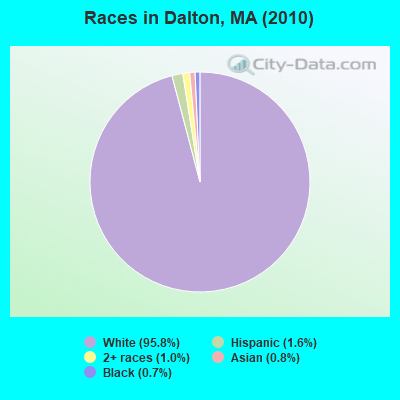
- 6,46995.8%White alone
- 1091.6%Hispanic
- 681.0%Two or more races
- 530.8%Asian alone
- 480.7%Black alone
- 40.06%American Indian alone
- 40.06%Other race alone
- 10.01%Native Hawaiian and Other
Pacific Islander alone
Races in Dalton detailed stats: ancestries, foreign born residents, place of birth
According to our research of Massachusetts and other state lists, there were 6 registered sex offenders living in Dalton, Massachusetts as of May 19, 2024.
The ratio of all residents to sex offenders in Dalton is 1,126 to 1.
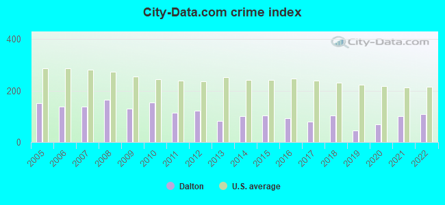
Type |
2009 |
2010 |
2011 |
2012 |
2013 |
2014 |
2015 |
2016 |
2017 |
2018 |
2019 |
2020 |
2021 |
2022 |
|---|---|---|---|---|---|---|---|---|---|---|---|---|---|---|
| Murders (per 100,000) | 0 (0.0) | 0 (0.0) | 0 (0.0) | 0 (0.0) | 0 (0.0) | 0 (0.0) | 0 (0.0) | 0 (0.0) | 0 (0.0) | 0 (0.0) | 0 (0.0) | 0 (0.0) | 0 (0.0) | 0 (0.0) |
| Rapes (per 100,000) | 1 (15.1) | 3 (44.4) | 1 (14.7) | 0 (0.0) | 2 (29.7) | 3 (44.7) | 2 (30.0) | 1 (15.1) | 0 (0.0) | 4 (61.0) | 1 (15.3) | 0 (0.0) | 2 (31.0) | 2 (31.9) |
| Robberies (per 100,000) | 1 (15.1) | 0 (0.0) | 0 (0.0) | 3 (44.3) | 0 (0.0) | 0 (0.0) | 1 (15.0) | 0 (0.0) | 0 (0.0) | 0 (0.0) | 0 (0.0) | 0 (0.0) | 1 (15.5) | 3 (47.8) |
| Assaults (per 100,000) | 17 (257.0) | 21 (310.8) | 16 (235.4) | 18 (265.7) | 3 (44.6) | 9 (134.0) | 12 (179.7) | 11 (165.6) | 15 (227.2) | 10 (152.5) | 5 (76.4) | 17 (261.5) | 16 (248.0) | 12 (191.3) |
| Burglaries (per 100,000) | 29 (438.3) | 17 (251.6) | 20 (294.2) | 27 (398.6) | 20 (297.4) | 19 (282.9) | 22 (329.5) | 17 (255.9) | 17 (257.5) | 5 (76.3) | 8 (122.2) | 3 (46.2) | 9 (139.5) | 6 (95.6) |
| Thefts (per 100,000) | 49 (740.6) | 49 (725.3) | 35 (514.9) | 35 (516.7) | 47 (698.9) | 29 (431.7) | 24 (359.4) | 44 (662.5) | 24 (363.5) | 21 (320.3) | 12 (183.3) | 13 (200.0) | 15 (232.5) | 26 (414.5) |
| Auto thefts (per 100,000) | 1 (15.1) | 8 (118.4) | 11 (161.8) | 5 (73.8) | 1 (14.9) | 1 (14.9) | 2 (30.0) | 2 (30.1) | 1 (15.1) | 5 (76.3) | 2 (30.6) | 4 (61.5) | 3 (46.5) | 5 (79.7) |
| Arson (per 100,000) | 0 (0.0) | 3 (44.4) | 1 (14.7) | 2 (29.5) | 2 (29.7) | 2 (29.8) | 7 (104.8) | 1 (15.1) | 0 (0.0) | 0 (0.0) | 1 (15.3) | 1 (15.4) | 1 (15.5) | 0 (0.0) |
| City-Data.com crime index | 129.5 | 153.8 | 113.0 | 120.9 | 82.7 | 100.8 | 104.2 | 92.0 | 79.2 | 103.6 | 45.8 | 68.5 | 101.8 | 107.8 |
The City-Data.com crime index weighs serious crimes and violent crimes more heavily. Higher means more crime, U.S. average is 246.1. It adjusts for the number of visitors and daily workers commuting into cities.
Crime rate in Dalton detailed stats: murders, rapes, robberies, assaults, burglaries, thefts, arson
Full-time law enforcement employees in 2021, including police officers: 13 (12 officers - 10 male; 2 female).
| Officers per 1,000 residents here: | 1.86 |
| Massachusetts average: | 2.53 |
 Recent articles from our blog. Our writers, many of them Ph.D. graduates or candidates, create easy-to-read articles on a wide variety of topics.

 | 2023 Real Estate Observations (5278 replies) |
| How About Those Patriots? (1187 replies) |
| 2022 Real Estate Observations (1122 replies) |
| Why is BPS so bad and what should be done to improve it? (589 replies) |
| Boston (the city) Has Lost Its Allure for Me (141 replies) |
| Black bear sightings (42 replies) |
Latest news from Dalton, MA collected exclusively by city-data.com from local newspapers, TV, and radio stations
Dalton, MA City Guides:
Ancestries: Irish (28.0%), Italian (18.0%), English (17.8%), German (14.8%), French (10.1%), Polish (7.7%).
Current Local Time: EST time zone
Incorporated in 1784
Elevation: 1199 feet
Land area: 21.8 square miles.
Population density: 310 people per square mile (very low).
115 residents are foreign born
| This town: | 1.7% |
| Massachusetts: | 12.2% |
| Dalton town: | 1.7% ($1,917) |
| Massachusetts: | 1.3% ($2,336) |
Nearest city with pop. 50,000+: Albany, NY  (34.1 miles , pop. 95,658).
Nearest city with pop. 200,000+: Boston, MA (106.4 miles , pop. 589,141).
Nearest city with pop. 1,000,000+: Bronx, NY (118.2 miles , pop. 1,332,650).
Nearest cities:
), ), ), ), ), ), )Latitude: 42.47 N, Longitude: 73.16 W
Area code: 413

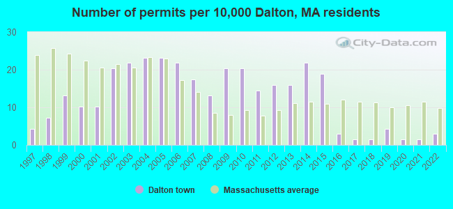
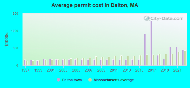
Single-family new house construction building permits:
- 2022: 2 buildings, average cost: $447,900
- 2021: 1 building, cost: $536,000
- 2020: 1 building, cost: $536,000
- 2019: 3 buildings, average cost: $186,100
- 2018: 1 building, cost: $300,000
- 2017: 1 building, cost: $1,295,000
- 2016: 2 buildings, average cost: $909,200
- 2015: 13 buildings, average cost: $178,600
- 2014: 15 buildings, average cost: $178,600
- 2013: 11 buildings, average cost: $178,600
- 2012: 11 buildings, average cost: $178,600
- 2011: 10 buildings, average cost: $178,600
- 2010: 14 buildings, average cost: $178,600
- 2009: 14 buildings, average cost: $178,600
- 2008: 9 buildings, average cost: $178,600
- 2007: 12 buildings, average cost: $178,600
- 2006: 15 buildings, average cost: $178,600
- 2005: 16 buildings, average cost: $178,600
- 2004: 16 buildings, average cost: $178,600
- 2003: 15 buildings, average cost: $178,600
- 2002: 14 buildings, average cost: $178,600
- 2001: 7 buildings, average cost: $191,000
- 2000: 7 buildings, average cost: $191,000
- 1999: 9 buildings, average cost: $139,900
- 1998: 5 buildings, average cost: $160,400
- 1997: 3 buildings, average cost: $166,700
| Here: | 3.2% |
| Massachusetts: | 3.5% |
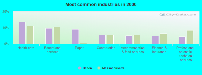
- Health care (13.6%)
- Educational services (9.7%)
- Paper (9.0%)
- Construction (5.4%)
- Accommodation & food services (5.1%)
- Finance & insurance (5.0%)
- Professional, scientific, technical services (4.5%)
- Paper (13.1%)
- Construction (9.6%)
- Professional, scientific, technical services (5.5%)
- Health care (5.5%)
- Educational services (4.7%)
- Public administration (4.2%)
- Finance & insurance (3.9%)
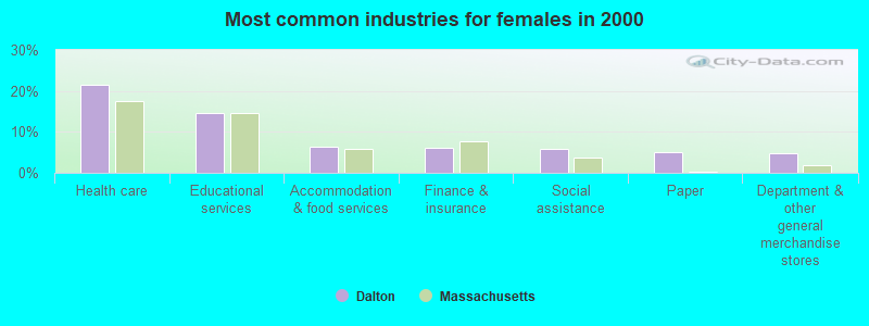
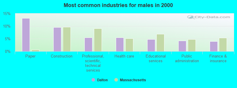
- Health care (21.6%)
- Educational services (14.6%)
- Accommodation & food services (6.5%)
- Finance & insurance (6.1%)
- Social assistance (5.7%)
- Paper (4.9%)
- Department & other general merchandise stores (4.8%)
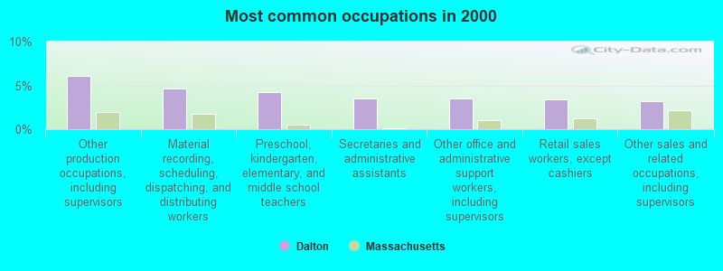
- Other production occupations, including supervisors (6.1%)
- Material recording, scheduling, dispatching, and distributing workers (4.7%)
- Preschool, kindergarten, elementary, and middle school teachers (4.2%)
- Secretaries and administrative assistants (3.5%)
- Other office and administrative support workers, including supervisors (3.5%)
- Retail sales workers, except cashiers (3.4%)
- Other sales and related occupations, including supervisors (3.2%)
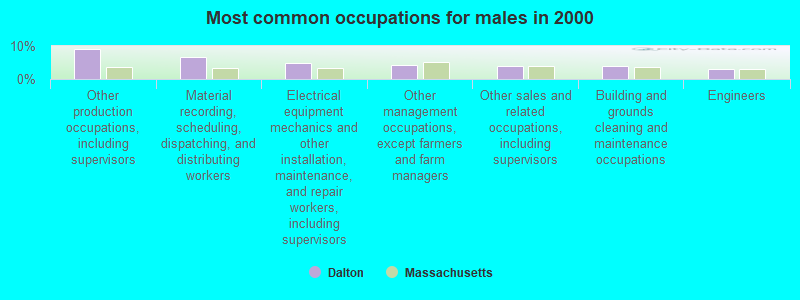
- Other production occupations, including supervisors (9.1%)
- Material recording, scheduling, dispatching, and distributing workers (6.7%)
- Electrical equipment mechanics and other installation, maintenance, and repair workers, including supervisors (4.8%)
- Other management occupations, except farmers and farm managers (4.3%)
- Other sales and related occupations, including supervisors (3.9%)
- Building and grounds cleaning and maintenance occupations (3.8%)
- Engineers (3.0%)

- Preschool, kindergarten, elementary, and middle school teachers (6.4%)
- Secretaries and administrative assistants (6.0%)
- Other office and administrative support workers, including supervisors (5.3%)
- Registered nurses (4.7%)
- Health technologists and technicians (4.3%)
- Nursing, psychiatric, and home health aides (4.3%)
- Retail sales workers, except cashiers (4.2%)
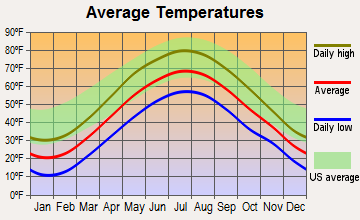
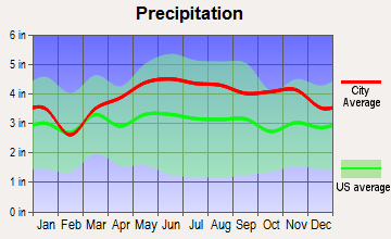
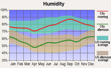
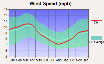
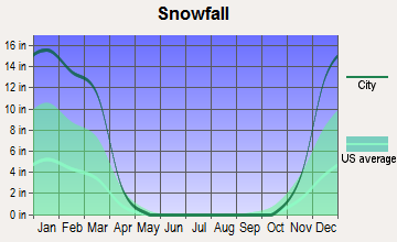
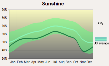
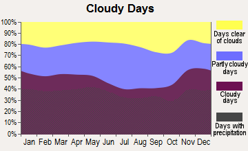
Average climate in Dalton, Massachusetts
Based on data reported by over 4,000 weather stations
(lower is better)
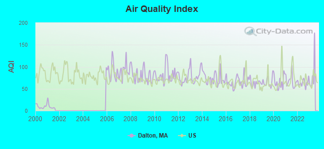
Air Quality Index (AQI) level in 2022 was 63.5. This is about average.
| City: | 63.5 |
| U.S.: | 72.6 |
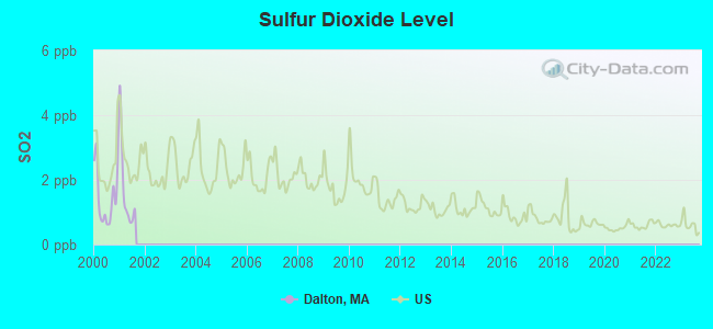
Sulfur Dioxide (SO2) [ppb] level in 2001 was 1.71. This is about average. Closest monitor was 0.5 miles away from the city center.
| City: | 1.71 |
| U.S.: | 1.51 |
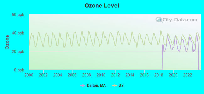
Ozone [ppb] level in 2022 was 27.5. This is better than average. Closest monitor was 2.3 miles away from the city center.
| City: | 27.5 |
| U.S.: | 33.3 |
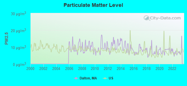
Particulate Matter (PM2.5) [µg/m3] level in 2022 was 6.68. This is better than average. Closest monitor was 4.1 miles away from the city center.
| City: | 6.68 |
| U.S.: | 8.11 |
Tornado activity:
Dalton-area historical tornado activity is slightly above Massachusetts state average. It is 19% smaller than the overall U.S. average.
On 8/28/1973, a category F4 (max. wind speeds 207-260 mph) tornado 13.6 miles away from the Dalton town center killed 4 people and injured 36 people and caused between $5,000,000 and $50,000,000 in damages.
On 5/29/1995, a category F4 tornado 20.8 miles away from the town center killed 3 people and injured 24 people and caused between $5,000,000 and $50,000,000 in damages.
Earthquake activity:
Dalton-area historical earthquake activity is significantly above Massachusetts state average. It is 69% smaller than the overall U.S. average.On 10/7/1983 at 10:18:46, a magnitude 5.3 (5.1 MB, 5.3 LG, 5.1 ML, Class: Moderate, Intensity: VI - VII) earthquake occurred 118.5 miles away from the city center
On 4/20/2002 at 10:50:47, a magnitude 5.3 (5.3 ML, Depth: 3.0 mi) earthquake occurred 143.7 miles away from the city center
On 4/20/2002 at 10:50:47, a magnitude 5.2 (5.2 MB, 4.2 MS, 5.2 MW, 5.0 MW) earthquake occurred 142.2 miles away from the city center
On 1/19/1982 at 00:14:42, a magnitude 4.7 (4.5 MB, 4.7 MD, 4.5 LG, Class: Light, Intensity: IV - V) earthquake occurred 106.4 miles away from the city center
On 10/16/2012 at 23:12:25, a magnitude 4.7 (4.7 ML, Depth: 10.0 mi) earthquake occurred 148.8 miles away from the city center
On 6/17/1991 at 08:53:16, a magnitude 4.1 (4.0 MB, 4.0 LG, Depth: 3.1 mi) earthquake occurred 78.0 miles away from the city center
Magnitude types: regional Lg-wave magnitude (LG), body-wave magnitude (MB), duration magnitude (MD), local magnitude (ML), surface-wave magnitude (MS), moment magnitude (MW)
Natural disasters:
The number of natural disasters in Berkshire County (21) is greater than the US average (15).Major Disasters (Presidential) Declared: 10
Emergencies Declared: 10
Causes of natural disasters: Floods: 5, Snowstorms: 5, Storms: 5, Hurricanes: 4, Winter Storms: 4, Blizzards: 2, Snows: 2, Snowfall: 1, Tropical Storm: 1, Wind: 1, Other: 1 (Note: some incidents may be assigned to more than one category).

Hospitals and medical centers in Dalton:
Other hospitals and medical centers near Dalton:
- MT GREYLOCK EXTENDED CARE FACILITY (Nursing Home, about 5 miles away; PITTSFIELD, MA)
- BERKSHIRE MEDICAL CENTER INC Acute Care Hospitals (about 5 miles away; PITTSFIELD, MA)
- BERKSHIRE PLACE (Nursing Home, about 5 miles away; PITTSFIELD, MA)
- HOSPICE OF THE BERKSHIRES, INC (Hospital, about 6 miles away; PITTSFIELD, MA)
- HILLCREST COMMONS NURSING AND REHABILITATION CENTER (Nursing Home, about 6 miles away; PITTSFIELD, MA)
- CENTER FOR OPTIMUM CARE-BERKSHIRE (Nursing Home, about 6 miles away; PITTSFIELD, MA)
- BERKSHIRE VISITING NURSE ASSOCIATION (Home Health Center, about 7 miles away; PITTSFIELD, MA)
Colleges/universities with over 2000 students nearest to Dalton:
- Williams College (about 17 miles; Williamstown, MA; Full-time enrollment: 2,141)
- Smith College (about 29 miles; Northampton, MA; FT enrollment: 3,549)
- Westfield State University (about 31 miles; Westfield, MA; FT enrollment: 5,548)
- Hudson Valley Community College (about 31 miles; Troy, NY; FT enrollment: 9,346)
- Rensselaer Polytechnic Institute (about 32 miles; Troy, NY; FT enrollment: 6,940)
- The Sage Colleges (about 33 miles; Troy, NY; FT enrollment: 2,499)
- Holyoke Community College (about 33 miles; Holyoke, MA; FT enrollment: 4,911)
Public high school in Dalton:
- HORACE MANN SCHOOL FOR THE DEAF (Students: 133, Location: 40 ARMINGTON STREET, Grades: PK-12)
Private high school in Dalton:
Public elementary/middle schools in Dalton:
- JACKSON MANN (Students: 579, Location: 40 ARMINGTON STREET, Grades: PK-8)
- GARDNER PILOT ACADEMY (Location: 30 ATHOL STREET, Grades: PK-8)
Private elementary/middle school in Dalton:
Points of interest:
Notable locations in Dalton: Wahconah County Club (A), Dalton Ambulance and Rescue (B), Dalton Fire Department (C), Crane Museum (D), Dalton Townhall (E), Dalton Free Public Library (F), Dalton Grange Hall Number 23 (G). Display/hide their locations on the map
Churches in Dalton include: Grace Episcopal Church (A), First Congregational Church (B), Dalton United Methodist Church (C), Berkshire First Church of the Nazarene (D). Display/hide their locations on the map
Cemeteries: East Main Street Cemetery (1), Ashuelot Cemetery (2), Fairview Cemetery (3). Display/hide their locations on the map
Lakes and reservoirs: Gore Pond (A), Anthony Pond (B), East Branch Housatonic River Reservoir (C), Center Pond (D), Hathaway Reservoir (E), Egypt Reservoir (F), Little Egypt Reservoir (G). Display/hide their locations on the map
Streams, rivers, and creeks: Weston Brook (A), Walker Brook (B), Wahconah Falls Brook (C), Anthony Brook (D), Hathaway Brook (E), Cleveland Brook (F). Display/hide their locations on the map
Parks in Dalton include: Pine Grove Park (1), Wahconah Falls State Park (2), American Legion Park (3). Display/hide their locations on the map
Hotels: Dalton House the Lodgings (955 Main Street) (1), Shamrock Village Inn (633 Main Street) (2). Display/hide their approximate locations on the map
Birthplace of: Burr Chamberlain - Football player and coach, Jeff Reardon - Baseball player, Winthrop M. Crane - Politician, Byron Weston - Politician.
Drinking water stations with addresses in Dalton that have no violations reported:
- DALTON FIRE DISTRICT (Population served: 6,441, Primary Water Source Type: Purch surface water)
| This town: | 2.4 people |
| Massachusetts: | 2.5 people |
| This town: | 66.8% |
| Whole state: | 63.0% |
| This town: | 7.8% |
| Whole state: | 7.0% |
Likely homosexual households (counted as self-reported same-sex unmarried-partner households)
- Lesbian couples: 0.4% of all households
- Gay men: 0.2% of all households
| This town: | 2.7% |
| Whole state: | 9.3% |
| This town: | 0.8% |
| Whole state: | 4.4% |
112 people in nursing homes in 2000
Banks with branches in Dalton (2011 data):
- TD Bank, National Association: Dalton Branch at 431 Main Street, branch established on 1962/10/01. Info updated 2010/10/04: Bank assets: $188,912.6 mil, Deposits: $153,149.8 mil, headquarters in Wilmington, DE, positive income, 1314 total offices, Holding Company: Toronto-Dominion Bank, The
- Berkshire Bank: Dalton Branch at 397 Main Street, branch established on 2008/11/03. Info updated 2011/08/24: Bank assets: $3,955.6 mil, Deposits: $3,176.2 mil, headquarters in Pittsfield, MA, positive income, Commercial Lending Specialization, 64 total offices
- The Pittsfield Co-operative Bank: Dalton Branch at 488 Main Street, branch established on 1962/01/01. Info updated 2006/11/03: Bank assets: $230.2 mil, Deposits: $182.7 mil, headquarters in Pittsfield, MA, positive income, 4 total offices
For population 15 years and over in Dalton:
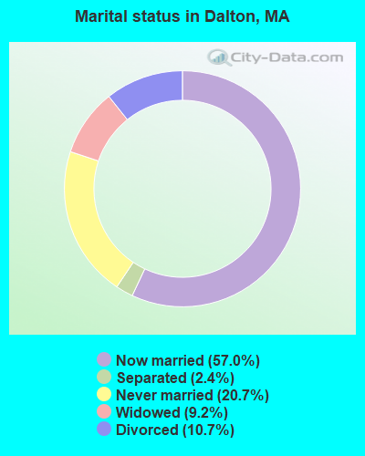
- Never married: 20.7%
- Now married: 57.0%
- Separated: 2.4%
- Widowed: 9.2%
- Divorced: 10.7%
For population 25 years and over in Dalton:
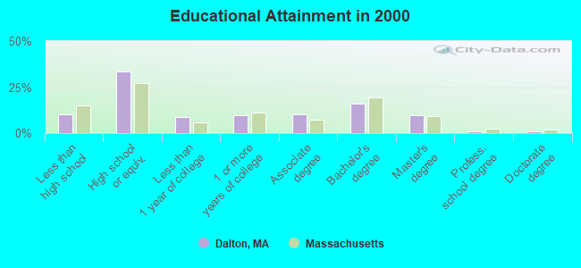
- High school or higher: 90.0%
- Bachelor's degree or higher: 28.0%
- Graduate or professional degree: 12.0%
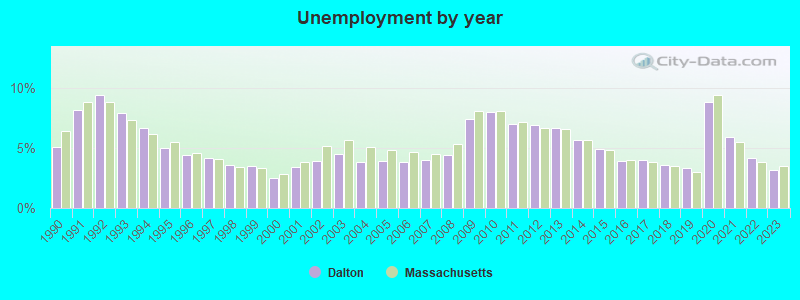
- Unemployed: 2.0%
- Mean travel time to work (commute): 17.7 minutes
| Here: | 9.8 |
| Massachusetts average: | 13.1 |


Graphs represent county-level data. Detailed 2008 Election Results
Religion statistics for Dalton, MA (based on Berkshire County data)


| Religion | Adherents | Congregations |
|---|---|---|
| Catholic | 50,187 | 32 |
| Mainline Protestant | 9,895 | 63 |
| Other | 3,647 | 20 |
| Evangelical Protestant | 2,817 | 28 |
| Black Protestant | 233 | 2 |
| Orthodox | 225 | 2 |
| None | 64,215 | - |
Food Environment Statistics:
| Berkshire County: | 2.54 / 10,000 pop. |
| Massachusetts: | 1.98 / 10,000 pop. |
| Berkshire County: | 1.61 / 10,000 pop. |
| Massachusetts: | 2.22 / 10,000 pop. |
| Berkshire County: | 4.08 / 10,000 pop. |
| Massachusetts: | 1.77 / 10,000 pop. |
| Berkshire County: | 15.00 / 10,000 pop. |
| Massachusetts: | 8.76 / 10,000 pop. |
| Berkshire County: | 8.0% |
| Massachusetts: | 8.1% |
| Here: | 22.8% |
| Massachusetts: | 22.5% |
| Berkshire County: | 9.9% |
| Massachusetts: | 16.5% |
Businesses in Dalton, MA
- MasterBrand Cabinets: 1
Strongest AM radio stations in Dalton:
- WUHN (1110 AM; daytime; 5 kW; PITTSFIELD, MA; Owner: WEINER BROADCASTING, INC.)
- WNNZ (640 AM; 50 kW; WESTFIELD, MA; Owner: CLEAR CHANNEL BROADCASTING LICENSES, INC.)
- WBRK (1340 AM; 1 kW; PITTSFIELD, MA; Owner: WBRK, INC.)
- WGY (810 AM; 50 kW; SCHENECTADY, NY; Owner: CLEAR CHANNEL BROADCASTING LICENSES, INC.)
- WPTR (1540 AM; 50 kW; ALBANY, NY; Owner: KIMTRON, INC.)
- WBEC (1420 AM; 1 kW; PITTSFIELD, MA; Owner: GREAT NORTHERN RADIO, LLC)
- WTIC (1080 AM; 50 kW; HARTFORD, CT; Owner: INFINITY RADIO OPERATIONS INC.)
- WCRN (830 AM; 50 kW; WORCESTER, MA; Owner: CARTER BROADCASTING CORPORATION)
- WVNE (760 AM; daytime; 25 kW; LEICESTER, MA; Owner: BLOUNT MASSCOM, INC.)
- WHYN (560 AM; 5 kW; SPRINGFIELD, MA; Owner: CLEAR CHANNEL BROADCASTING LICENSES, INC.)
- WSBS (860 AM; 3 kW; GREAT BARRINGTON, MA; Owner: BERKSHIRE BROADCASTING CO., INC.)
- WIZZ (1520 AM; daytime; 10 kW; GREENFIELD, MA; Owner: P. & M. RADIO, LLC)
- WROW (590 AM; 5 kW; ALBANY, NY; Owner: 6 JOHNSON ROAD LICENSES, INC.)
Strongest FM radio stations in Dalton:
- WAMC-FM (90.3 FM; ALBANY, NY; Owner: WAMC)
- WBEC-FM (105.5 FM; PITTSFIELD, MA; Owner: GREAT NORTHERN RADIO, LLC)
- WUPE (95.9 FM; PITTSFIELD, MA; Owner: WEINER BROADCASTING, INC.)
- WHVP (91.1 FM; HUDSON, NY; Owner: SOUND OF LIFE, INC.)
- WZEC (97.5 FM; HOOSICK FALLS, NY; Owner: GREAT NORTHERN RADIO, LLC)
- WBRK-FM (101.7 FM; PITTSFIELD, MA; Owner: WBRK, INC.)
- WEQX (102.7 FM; MANCHESTER, VT; Owner: NORTHSHIRE COMMUNICATIONS, INC.)
- WJAN (95.1 FM; SUNDERLAND, VT; Owner: 6 JOHNSON ROAD LICENSES, INC.)
- WVAY (100.7 FM; WILMINGTON, VT; Owner: GREAT NORTHERN RADIO, L.L.C.)
- WMNB (100.1 FM; NORTH ADAMS, MA; Owner: BERKSHIRE BROADCASTING CO., INC.)
- WAMQ (105.1 FM; GREAT BARRINGTON, MA; Owner: WAMC)
- WHYN-FM (93.1 FM; SPRINGFIELD, MA; Owner: CLEAR CHANNEL BROADCASTING LICENSES, INC.)
- WRNX (100.9 FM; AMHERST, MA; Owner: WESTERN MASSACHUSETTS RADIO COMPANY)
- WPVQ (95.3 FM; GREENFIELD, MA; Owner: GREAT NORTHERN RADIO, L.L.C.)
- WFCR (88.5 FM; AMHERST, MA; Owner: UNIVERSITY OF MASSACHUSETTS)
- WAJZ (96.3 FM; VOORHEESVILLE, NY; Owner: 6 JOHNSON ROAD LICENSES, INC.)
- WZMR (104.9 FM; ALTAMONT, NY; Owner: 6 JOHNSON ROAD LICENSES, INC.)
- WAQY (102.1 FM; SPRINGFIELD, MA; Owner: SAGA COMMUNICATIONS OF NEW ENGLAND, LLC)
- WYJB (95.5 FM; ALBANY, NY; Owner: 6 JOHNSON ROAD LICENSES, INC.)
- WRSY (101.5 FM; MARLBORO, VT; Owner: GREAT NORTHERN RADIO, L.L.C.)
TV broadcast stations around Dalton:
- WCDC-TV (Channel 19; ADAMS, MA; Owner: YOUNG BROADCASTING OF ALBANY, INC.)
- WTIC-TV (Channel 61; HARTFORD, CT; Owner: TRIBUNE TELEVISION COMPANY)
- W38DL (Channel 38; ADAMS, ETC., MA; Owner: WNYT-TV, LLC)
- W35BK (Channel 35; PLAINFIELD, MA; Owner: LYDIA SYLVANE STOCKWELL)
- W07AI (Channel 7; PITTSFIELD, ETC., MA; Owner: WNYT-TV, LLC)
- National Bridge Inventory (NBI) Statistics
- 12Number of bridges
- 102ft / 31.3mTotal length
- $19,707,000Total costs
- 60,501Total average daily traffic
- 5,576Total average daily truck traffic
- 82,046Total future (year 2032) average daily traffic
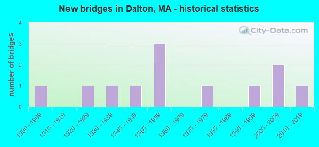
- New bridges - historical statistics
- 11900-1909
- 11920-1929
- 11930-1939
- 11940-1949
- 31950-1959
- 11970-1979
- 11990-1999
- 22000-2009
- 12010-2019
FCC Registered Antenna Towers:
1- Windsor Mountain (Lat: 42.511944 Lon: -73.117222), Type: 60.3, Overall height: 54.8 m, Registrant: Venic-e, Phone: (941) 488-4205
FCC Registered Private Land Mobile Towers:
2- 12 Cleveland Rd (Lat: 42.512028 Lon: -73.117333), Type: Tower, Structure height: 15 m, Overall height: 49 m, Call Sign: WPJR783,
Assigned Frequencies: 929.187 MHz, Grant Date: 09/26/1996, Expiration Date: 09/26/2006, Cancellation Date: 08/08/2001, Certifier: Steven D Jacoby, Registrant: Fiorio Communications Consulting, 12110451 Twin Rivers Rd Ste 207, Columbia, MD 21044, Fax: (301) 591-5961
- 12 Cleveland Rd (Lat: 42.512028 Lon: -73.117333), Type: Tower, Structure height: 15 m, Overall height: 49 m, Call Sign: WPKS667,
Assigned Frequencies: 929.387 MHz, Grant Date: 06/25/1997, Expiration Date: 06/25/2007, Cancellation Date: 11/10/2004, Certifier: Kenneth Goldstein, Registrant: Alston & Bird LLP, 601 Pennsylvania Ave., Nw, North Building, 10th Floor, Washington, DC 20004, Phone: (202) 756-3376, Fax: (202) 756-3333, Email:
FCC Registered Broadcast Land Mobile Towers:
5- 20 Flansburg Ave Fire Station (Lat: 42.472028 Lon: -73.166222), Call Sign: WYX538,
Assigned Frequencies: 154.740 MHz, 154.875 MHz, Grant Date: 03/25/2014, Expiration Date: 03/08/2024, Registrant: Washington Radio Reports, Gettysburg, PA 17325, Phone: (717) 334-0668, Fax: (717) 334-6440
- DALTON BASE, End Of Monahan Road (Lat: 42.521389 Lon: -73.130556), Type: Tower, Structure height: 24.4 m, Call Sign: KYU480,
Assigned Frequencies: 151.340 MHz, Grant Date: 04/13/2022, Expiration Date: 07/08/2032, Certifier: William Sanger, Registrant: American Medical Response, 6200 S Syracuse Way Ste 200, Greenwood Village, CO 80111, Phone: (303) 495-1541, Fax: (800) 396-0038, Email:
- 1 Mi N Of Dalton Ave On Rt 8 (Lat: 42.482583 Lon: -73.173444), Call Sign: KTG958, Licensee ID: L00030601,
Assigned Frequencies: 151.595 MHz, Grant Date: 07/11/1996, Expiration Date: 08/26/2001, Cancellation Date: 10/29/2001, Registrant: Transit Mixed Concrete Corporation, Pittsfield, MA 01201, Phone: (413) 442-6926
- Lat: 42.473167 Lon: -73.134000, Call Sign: WPYG975,
Assigned Frequencies: 452.187 MHz, 457.187 MHz, Grant Date: 07/11/2023, Expiration Date: 08/11/2033, Certifier: Jeremy Stachowicz, Registrant: Wahconah Country Club, 20 Orchard Rd, Dalton, MA 01226, Phone: (508) 254-4396, Email:
- Lat: 42.468000 Lon: -73.136083, Call Sign: WQKZ249,
Assigned Frequencies: 467.212 MHz, Grant Date: 09/24/2019, Expiration Date: 11/03/2029, Certifier: Margaret K Foster, Registrant: Central Berkshire Regional School District, 254 Hinsdale Road, Dalton, MA 01227, Phone: (413) 684-0320, Fax: (413) 684-4088, Email:
FCC Registered Microwave Towers:
1- 7775 Ft N Of Junction Of Berkshire Trail And Wahconah Rd (Lat: 42.513972 Lon: -73.117028), Overall height: 30.5 m, Call Sign: WPNM838,
Assigned Frequencies: 7100.00 MHz, Grant Date: 07/09/1998, Expiration Date: 04/01/2023, Registrant: Nexstar Media Inc., 545 E. John Carpenter Freeway, Irving, TX 75062, Phone: (972) 373-8800, Fax: (972) 373-8888, Email:
FCC Registered Amateur Radio Licenses:
54 (See the full list of FCC Registered Amateur Radio Licenses in Dalton)FAA Registered Aircraft Manufacturers and Dealers:
2- STREAMLINE AVIATION INC, 839 Main St, Dalton, MA 01226
Certificate: 00-0774 (Corporation), Certificate Issue Date: 04/18/2000, Expiration Date: 04/17/2001 - WEBER WILLIAM A, 839 Main St, Dalton, MA 01226
Certificate: 03-1426 (Individual), Certificate Issue Date: 08/20/2003, Expiration Date: 08/19/2004
FAA Registered Aircraft:
2- Aircraft: SCHWEIZER SGS 1-26B (Category: Land, Weight: Up to 12,499 Pounds, Speed: 58 mph), Engine: None
N-Number: 3813A, N3813A, N-3813A, Serial Number: 86, Year manufactured: 1958, Airworthiness Date: 10/02/1958, Certificate Issue Date: 04/05/1972
Registrant (Individual): David C Badeau, 66 Sunnyside Drive, Dalton, MA 01226 - Aircraft: PIPER PA-23-250 (Category: Land, Engines: 2, Seats: 6, Weight: Up to 12,499 Pounds, Speed: 150 mph), Engine: LYCOMING TI0-540 SER (310 HP) (Reciprocating)
N-Number: 5470Y, N5470Y, N-5470Y, Serial Number: 27-2560, Year manufactured: 1964, Airworthiness Date: 05/22/1964, Certificate Issue Date: 07/03/2014
Registrant (Individual): Mark J Weber, 52 East St, Dalton, MA 01226
2002 - 2018 National Fire Incident Reporting System (NFIRS) incidents
- Fire incident types reported to NFIRS in Dalton, MA
- 24568.1%Structure Fires
- 7220.0%Outside Fires
- 328.9%Mobile Property/Vehicle Fires
- 113.1%Other
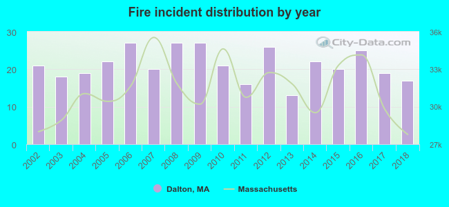 Based on the data from the years 2002 - 2018 the average number of fire incidents per year is 21. The highest number of fires - 27 took place in 2006, and the least - 13 in 2013. The data has a decreasing trend.
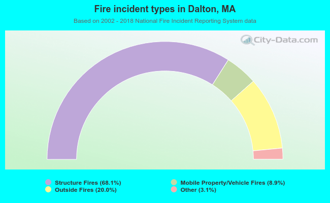 When looking into fire subcategories, the most incidents belonged to: Structure Fires (68.1%), and Outside Fires (20.0%).
| Most common first names in Dalton, MA among deceased individuals | ||
| Name | Count | Lived (average) |
|---|---|---|
| Mary | 86 | 83.0 years |
| William | 77 | 72.9 years |
| John | 71 | 74.8 years |
| Margaret | 51 | 81.5 years |
| George | 50 | 78.6 years |
| Edward | 40 | 73.5 years |
| Charles | 37 | 77.3 years |
| Elizabeth | 37 | 81.3 years |
| Robert | 35 | 71.9 years |
| Joseph | 34 | 74.4 years |
| Most common last names in Dalton, MA among deceased individuals | ||
| Last name | Count | Lived (average) |
|---|---|---|
| Smith | 28 | 79.0 years |
| Schnopp | 18 | 80.9 years |
| White | 15 | 78.0 years |
| Callahan | 15 | 77.1 years |
| Daly | 14 | 76.3 years |
| Crosier | 13 | 76.8 years |
| Adams | 13 | 80.5 years |
| Martin | 13 | 77.1 years |
| Phillips | 12 | 72.9 years |
| Clark | 12 | 79.7 years |
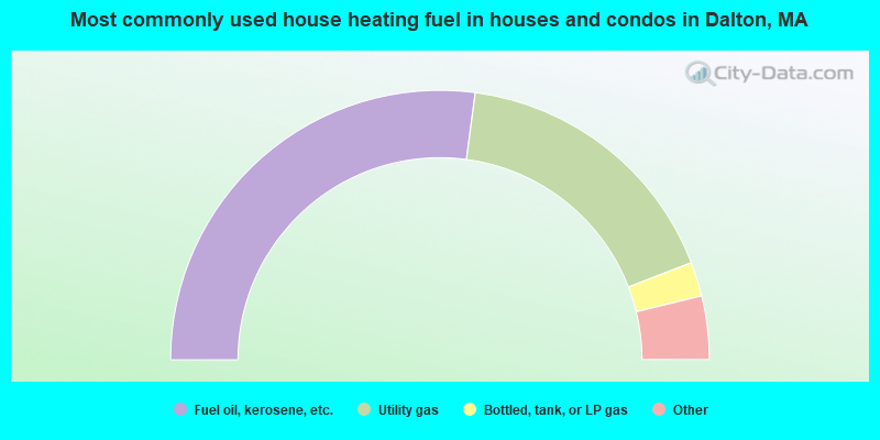
- 54.2%Fuel oil, kerosene, etc.
- 34.1%Utility gas
- 4.1%Bottled, tank, or LP gas
- 4.0%Electricity
- 2.4%Wood
- 1.2%Other fuel
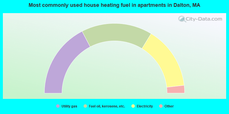
- 34.7%Utility gas
- 32.8%Fuel oil, kerosene, etc.
- 28.9%Electricity
- 2.3%Bottled, tank, or LP gas
- 1.3%Wood
Dalton compared to Massachusetts state average:
- Median house value below state average.
- Unemployed percentage significantly below state average.
- Black race population percentage significantly below state average.
- Hispanic race population percentage significantly below state average.
- Median age above state average.
- Foreign-born population percentage significantly below state average.
- Length of stay since moving in significantly above state average.
- Number of rooms per house significantly below state average.
- House age significantly below state average.
- Number of college students below state average.
Dalton on our top lists:
- #9 on the list of "Top 101 cities with largest percentage of males in industries: paper (population 5,000+)"
- #9 on the list of "Top 101 cities with largest percentage of females in industries: paper (population 5,000+)"
- #15 on the list of "Top 101 cities with largest percentage of males in occupations: material recording, scheduling, dispatching, and distributing workers (population 5,000+)"
- #16 on the list of "Top 101 cities with largest percentage of males in occupations: secretaries and administrative assistants (population 5,000+)"
- #17 on the list of "Top 101 cities with largest percentage of females in occupations: communications equipment operators (population 5,000+)"
- #23 on the list of "Top 101 cities with largest percentage of males in occupations: bus drivers (population 5,000+)"
- #26 on the list of "Top 101 cities with largest percentage of males in industries: fuel dealers (population 5,000+)"
- #27 on the list of "Top 101 cities with largest percentage of females in industries: jewelry, luggage, and leather goods stores (population 5,000+)"
- #35 on the list of "Top 101 cities with largest percentage of males in occupations: plant and system operators (population 5,000+)"
- #35 on the list of "Top 101 cities with largest percentage of females in industries: furniture and home furnishing merchant wholesalers (population 5,000+)"
- #51 on the list of "Top 101 cities with largest percentage of males in occupations: architects, surveyors, and cartographers (population 5,000+)"
- #64 on the list of "Top 101 cities with largest percentage of males in industries: lumber and other construction materials merchant wholesalers (population 5,000+)"
- #81 on the list of "Top 101 cities with largest percentage of males in industries: building material and garden equipment and supplies dealers (population 5,000+)"
- #83 on the list of "Top 101 cities with largest percentage of females in industries: plastics and rubber products (population 5,000+)"
- #86 on the list of "Top 101 cities with largest percentage of males in industries: plastics and rubber products (population 5,000+)"
- #14 on the list of "Top 101 counties with the lowest number of births per 1000 residents 2007-2013"
- #22 on the list of "Top 101 counties with the lowest percentage of residents relocating from other counties between 2010 and 2011"
- #28 on the list of "Top 101 counties with the lowest percentage of residents relocating to other counties in 2011"
- #53 on the list of "Top 101 counties with highest percentage of residents voting for Obama (Democrat) in the 2012 Presidential Election"
- #71 on the list of "Top 101 counties with the largest number of people moving out compared to moving in (pop. 50,000+)"

|
|
Total of 37 patent applications in 2008-2024.