Montague, Massachusetts
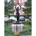
Montague: The Spinner, by Leon Cugnot, Displayed on Avenue A in Montague, Ma
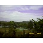
Montague: Unity Park
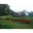
Montague: Barn and Flowers in Mondatuge MA
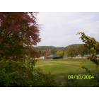
Montague: Unity Park
- add
your
Submit your own pictures of this town and show them to the world
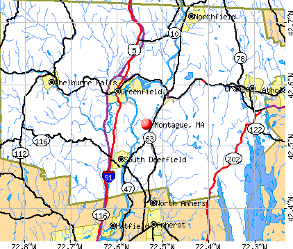
- OSM Map
- General Map
- Google Map
- MSN Map
Population change since 2000: -0.6%
 |
| Males: 4,106 | |
| Females: 4,331 |
| Median resident age: | 43.1 years |
| Massachusetts median age: | 39.2 years |
Zip codes: 01351.
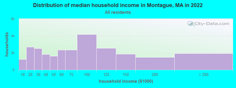
| Montague: | $58,203 |
| MA: | $94,488 |
Estimated per capita income in 2022: $32,419 (it was $17,794 in 2000)
Montague town income, earnings, and wages data
Estimated median house or condo value in 2022: $279,830 (it was $112,600 in 2000)
| Montague: | $279,830 |
| MA: | $534,700 |
Mean prices in 2022: all housing units: $313,377; detached houses: $324,224; townhouses or other attached units: $284,225; in 2-unit structures: $287,978; in 3-to-4-unit structures: $183,938; in 5-or-more-unit structures: $249,762; mobile homes: $62,200
Detailed information about poverty and poor residents in Montague, MA


- 7,62190.3%White alone
- 4385.2%Hispanic
- 1972.3%Two or more races
- 811.0%Black alone
- 670.8%Asian alone
- 150.2%American Indian alone
- 170.2%Other race alone
- 10.01%Native Hawaiian and Other
Pacific Islander alone
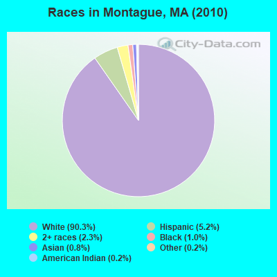
Races in Montague detailed stats: ancestries, foreign born residents, place of birth
According to our research of Massachusetts and other state lists, there were 10 registered sex offenders living in Montague, Massachusetts as of May 19, 2024.
The ratio of all residents to sex offenders in Montague is 844 to 1.
Type |
2009 |
2010 |
2011 |
2012 |
2013 |
2014 |
2015 |
2016 |
2017 |
2018 |
2019 |
2020 |
2021 |
2022 |
|---|---|---|---|---|---|---|---|---|---|---|---|---|---|---|
| Murders (per 100,000) | 0 (0.0) | 0 (0.0) | 0 (0.0) | 0 (0.0) | 0 (0.0) | 0 (0.0) | 0 (0.0) | 0 (0.0) | 0 (0.0) | 0 (0.0) | 0 (0.0) | 0 (0.0) | 0 (0.0) | 0 (0.0) |
| Rapes (per 100,000) | 5 (59.5) | 10 (118.5) | 0 (0.0) | 7 (82.0) | 4 (47.5) | 3 (35.9) | 2 (24.1) | 3 (36.4) | 8 (97.4) | 5 (60.7) | 4 (48.2) | 3 (36.7) | 0 (0.0) | 1 (11.7) |
| Robberies (per 100,000) | 3 (35.7) | 1 (11.9) | 4 (47.1) | 1 (11.7) | 3 (35.6) | 9 (107.6) | 4 (48.2) | 5 (60.7) | 0 (0.0) | 2 (24.3) | 4 (48.2) | 0 (0.0) | 4 (48.9) | 1 (11.7) |
| Assaults (per 100,000) | 40 (475.8) | 22 (260.8) | 57 (671.5) | 30 (351.3) | 38 (451.4) | 44 (526.0) | 68 (819.3) | 49 (594.5) | 56 (682.0) | 51 (619.3) | 41 (494.1) | 44 (537.6) | 61 (745.9) | 49 (571.0) |
| Burglaries (per 100,000) | 60 (713.7) | 47 (557.1) | 75 (883.6) | 81 (948.5) | 72 (855.3) | 57 (681.4) | 44 (530.1) | 65 (788.6) | 51 (621.1) | 22 (267.2) | 18 (216.9) | 16 (195.5) | 25 (305.7) | 19 (221.4) |
| Thefts (per 100,000) | 95 (1,130) | 85 (1,007) | 132 (1,555) | 127 (1,487) | 147 (1,746) | 140 (1,674) | 127 (1,530) | 111 (1,347) | 71 (864.7) | 71 (862.2) | 64 (771.3) | 45 (549.8) | 58 (709.2) | 40 (466.1) |
| Auto thefts (per 100,000) | 7 (83.3) | 7 (83.0) | 6 (70.7) | 6 (70.3) | 3 (35.6) | 4 (47.8) | 6 (72.3) | 2 (24.3) | 4 (48.7) | 2 (24.3) | 2 (24.1) | 3 (36.7) | 4 (48.9) | 8 (93.2) |
| Arson (per 100,000) | 3 (35.7) | 7 (83.0) | 3 (35.3) | 2 (23.4) | 2 (23.8) | 5 (59.8) | 2 (24.1) | 3 (36.4) | 0 (0.0) | 1 (12.1) | 0 (0.0) | 0 (0.0) | 0 (0.0) | 0 (0.0) |
| City-Data.com crime index | 255.3 | 236.5 | 278.2 | 270.8 | 271.6 | 284.6 | 301.7 | 277.2 | 296.3 | 234.9 | 199.8 | 175.4 | 217.5 | 168.6 |
The City-Data.com crime index weighs serious crimes and violent crimes more heavily. Higher means more crime, U.S. average is 246.1. It adjusts for the number of visitors and daily workers commuting into cities.
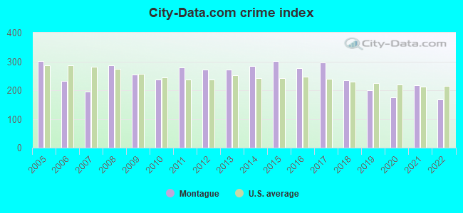
Crime rate in Montague detailed stats: murders, rapes, robberies, assaults, burglaries, thefts, arson
Full-time law enforcement employees in 2021, including police officers: 22 (17 officers - 16 male; 1 female).
| Officers per 1,000 residents here: | 2.08 |
| Massachusetts average: | 2.53 |
 Recent articles from our blog. Our writers, many of them Ph.D. graduates or candidates, create easy-to-read articles on a wide variety of topics.

 | Hillbilly Massachusetts (103 replies) |
| Is Massachusetts really just as expensive as NJ? (57 replies) |
| Is it possible to escape hunters, ATVs and noise in a rural area? (278 replies) |
| Coronavirus in Massachusetts (18048 replies) |
| UNBOXING MASSACHUSETTS: Did they get this right? (66 replies) |
| When is the insanity going to end? There has to be a real estate market crash, right? (99 replies) |
Latest news from Montague, MA collected exclusively by city-data.com from local newspapers, TV, and radio stations
Ancestries: Polish (21.1%), French (16.8%), English (14.6%), Irish (14.3%), German (9.2%), French Canadian (6.6%).
Current Local Time: EST time zone
Incorporated in 1775
Elevation: 235 feet
Land area: 30.4 square miles.
Population density: 278 people per square mile (very low).
349 residents are foreign born (1.9% Europe, 1.2% Asia, 0.5% Latin America, 0.5% North America).
| This town: | 4.1% |
| Massachusetts: | 12.2% |
| Montague town: | 1.6% ($1,748) |
| Massachusetts: | 1.3% ($2,336) |
Nearest city with pop. 50,000+: Chicopee, MA  (27.8 miles , pop. 54,653).
Nearest city with pop. 200,000+: Boston, MA (75.8 miles , pop. 589,141).
Nearest city with pop. 1,000,000+: Bronx, NY (137.7 miles , pop. 1,332,650).
Nearest cities:
), ), ), Latitude: 42.57 N, Longitude: 72.54 W
Area code: 413

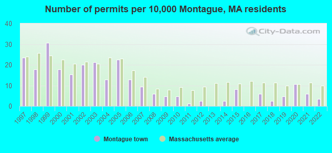
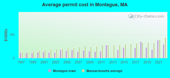
Single-family new house construction building permits:
- 2022: 3 buildings, average cost: $295,400
- 2021: 5 buildings, average cost: $381,100
- 2020: 9 buildings, average cost: $183,200
- 2019: 4 buildings, average cost: $227,500
- 2018: 2 buildings, average cost: $356,100
- 2017: 5 buildings, average cost: $220,000
- 2015: 7 buildings, average cost: $226,800
- 2014: 2 buildings, average cost: $178,500
- 2012: 2 buildings, average cost: $277,500
- 2011: 1 building, cost: $150,000
- 2010: 4 buildings, average cost: $141,300
- 2009: 4 buildings, average cost: $150,000
- 2008: 5 buildings, average cost: $165,500
- 2007: 8 buildings, average cost: $139,600
- 2006: 11 buildings, average cost: $174,500
- 2005: 19 buildings, average cost: $160,000
- 2004: 11 buildings, average cost: $176,600
- 2003: 18 buildings, average cost: $124,000
- 2002: 17 buildings, average cost: $124,000
- 2001: 13 buildings, average cost: $131,600
- 2000: 15 buildings, average cost: $128,600
- 1999: 26 buildings, average cost: $109,800
- 1998: 15 buildings, average cost: $105,700
- 1997: 20 buildings, average cost: $113,800
| Here: | 4.1% |
| Massachusetts: | 3.5% |
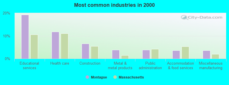
- Educational services (19.3%)
- Health care (11.8%)
- Construction (6.6%)
- Metal & metal products (3.9%)
- Public administration (3.8%)
- Accommodation & food services (3.6%)
- Miscellaneous manufacturing (3.6%)

- Educational services (14.1%)
- Construction (12.7%)
- Metal & metal products (5.9%)
- Public administration (4.7%)
- Miscellaneous manufacturing (4.6%)
- Health care (4.2%)
- Administrative & support & waste management services (3.7%)
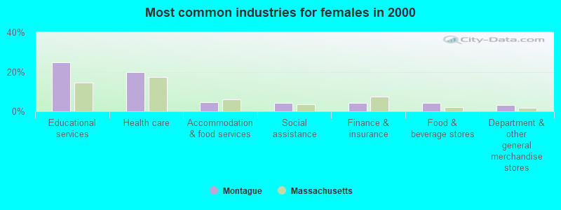
- Educational services (24.8%)
- Health care (19.9%)
- Accommodation & food services (4.5%)
- Social assistance (4.3%)
- Finance & insurance (4.3%)
- Food & beverage stores (4.2%)
- Department & other general merchandise stores (3.1%)
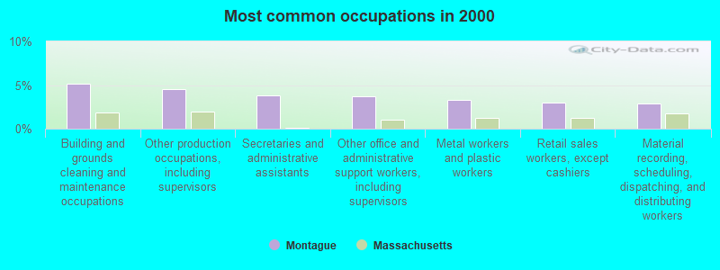
- Building and grounds cleaning and maintenance occupations (5.1%)
- Other production occupations, including supervisors (4.5%)
- Secretaries and administrative assistants (3.8%)
- Other office and administrative support workers, including supervisors (3.7%)
- Metal workers and plastic workers (3.3%)
- Retail sales workers, except cashiers (3.0%)
- Material recording, scheduling, dispatching, and distributing workers (2.9%)
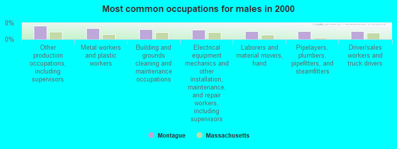
- Other production occupations, including supervisors (6.6%)
- Metal workers and plastic workers (5.3%)
- Building and grounds cleaning and maintenance occupations (4.8%)
- Electrical equipment mechanics and other installation, maintenance, and repair workers, including supervisors (4.7%)
- Laborers and material movers, hand (4.0%)
- Pipelayers, plumbers, pipefitters, and steamfitters (3.9%)
- Driver/sales workers and truck drivers (3.8%)
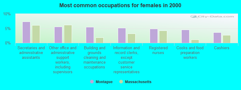
- Secretaries and administrative assistants (7.4%)
- Other office and administrative support workers, including supervisors (5.6%)
- Building and grounds cleaning and maintenance occupations (5.5%)
- Information and record clerks, except customer service representatives (5.2%)
- Registered nurses (4.8%)
- Cooks and food preparation workers (4.5%)
- Cashiers (3.6%)
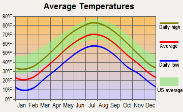
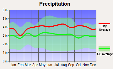
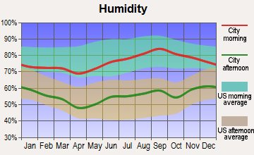
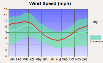
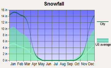
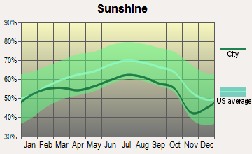
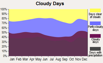
Average climate in Montague, Massachusetts
Based on data reported by over 4,000 weather stations
(lower is better)
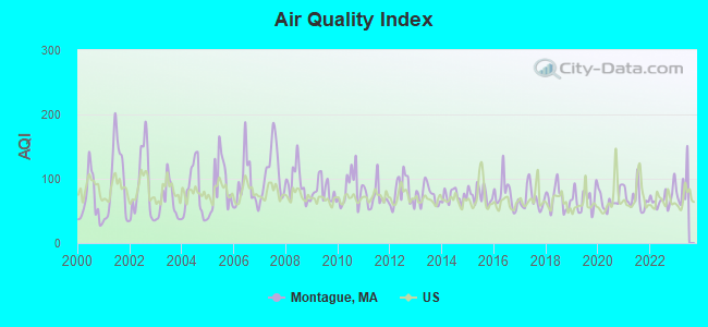
Air Quality Index (AQI) level in 2022 was 69.2. This is about average.
| City: | 69.2 |
| U.S.: | 72.6 |
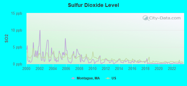
Sulfur Dioxide (SO2) [ppb] level in 2022 was 0.216. This is significantly better than average. Closest monitor was 3.1 miles away from the city center.
| City: | 0.216 |
| U.S.: | 1.515 |
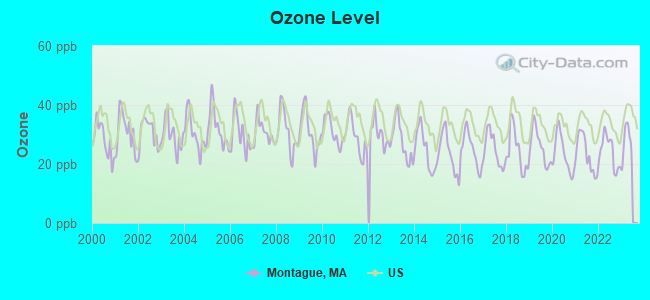
Ozone [ppb] level in 2022 was 24.1. This is better than average. Closest monitor was 0.4 miles away from the city center.
| City: | 24.1 |
| U.S.: | 33.3 |
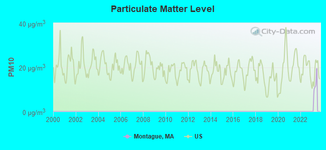
Particulate Matter (PM2.5) [µg/m3] level in 2022 was 7.26. This is about average. Closest monitor was 4.0 miles away from the city center.
| City: | 7.26 |
| U.S.: | 8.11 |
Tornado activity:
Montague-area historical tornado activity is above Massachusetts state average. It is 12% smaller than the overall U.S. average.
On 6/9/1953, a category F4 (max. wind speeds 207-260 mph) tornado 19.9 miles away from the Montague town center killed 90 people and injured 1228 people and caused between $50,000,000 and $500,000,000 in damages.
On 10/3/1979, a category F4 tornado 36.9 miles away from the town center killed 3 people and injured 500 people and caused between $50,000,000 and $500,000,000 in damages.
Earthquake activity:
Montague-area historical earthquake activity is significantly above Massachusetts state average. It is 70% smaller than the overall U.S. average.On 10/7/1983 at 10:18:46, a magnitude 5.3 (5.1 MB, 5.3 LG, 5.1 ML, Class: Moderate, Intensity: VI - VII) earthquake occurred 132.0 miles away from Montague center
On 4/20/2002 at 10:50:47, a magnitude 5.3 (5.3 ML, Depth: 3.0 mi) earthquake occurred 146.5 miles away from Montague center
On 4/20/2002 at 10:50:47, a magnitude 5.2 (5.2 MB, 4.2 MS, 5.2 MW, 5.0 MW) earthquake occurred 145.3 miles away from Montague center
On 1/19/1982 at 00:14:42, a magnitude 4.7 (4.5 MB, 4.7 MD, 4.5 LG, Class: Light, Intensity: IV - V) earthquake occurred 79.9 miles away from Montague center
On 10/16/2012 at 23:12:25, a magnitude 4.7 (4.7 ML, Depth: 10.0 mi) earthquake occurred 118.6 miles away from the city center
On 10/2/1994 at 11:27:22, a magnitude 3.7 (3.5 LG, 3.7 LG, Depth: 6.2 mi, Class: Light, Intensity: II - III) earthquake occurred 20.3 miles away from the city center
Magnitude types: regional Lg-wave magnitude (LG), body-wave magnitude (MB), duration magnitude (MD), local magnitude (ML), surface-wave magnitude (MS), moment magnitude (MW)
Natural disasters:
The number of natural disasters in Franklin County (20) is greater than the US average (15).Major Disasters (Presidential) Declared: 9
Emergencies Declared: 10
Causes of natural disasters: Floods: 5, Storms: 5, Hurricanes: 4, Snowstorms: 4, Winter Storms: 3, Blizzards: 2, Snows: 2, Snowfall: 1, Tropical Storm: 1, Wind: 1, Other: 1 (Note: some incidents may be assigned to more than one category).

Hospitals and medical centers near Montague:
- NURSE'S HOUSE CALL - GREENFIELD (Home Health Center, about 4 miles away; GREENFIELD, MA)
- YANKEE FAMILY DIALYSIS CENTER (Dialysis Facility, about 4 miles away; GREENFIELD, MA)
- POET'S SEAT HEALTH CARE CENTER (Nursing Home, about 4 miles away; GREENFIELD, MA)
- BAYSTATE FRANKLIN MEDICAL CENTER Acute Care Hospitals (about 4 miles away; GREENFIELD, MA)
- HOSPICE OF FRANKLIN COUNTY (Hospital, about 4 miles away; GREENFIELD, MA)
- GENTIVA HEALTH SERVICES (Home Health Center, about 4 miles away; GREENFIELD, MA)
- HOME CARE PRN INC (Home Health Center, about 4 miles away; GREENFIELD, MA)
Airports located in Montague:
- Turners Falls Airport (0B5) (Runways: 1, Air Taxi Ops: 100, Itinerant Ops: 5,000, Local Ops: 12,500)
Amtrak stations near Montague:
- 14 miles: AMHERST (RAILROAD ST.) . Services: enclosed waiting area, public payphones, free short-term parking, paid long-term parking, call for car rental service, call for taxi service, public transit connection.
- 19 miles: BRATTLEBORO (VERNON RD.) . Services: enclosed waiting area, public restrooms, call for car rental service, call for taxi service.
Operable nuclear power plant near Montague:
- 14 miles: Vermont Yankee in Vernon, VT.
Colleges/universities with over 2000 students nearest to Montague:
- University of Massachusetts-Amherst (about 13 miles; Amherst, MA; Full-time enrollment: 26,583)
- Smith College (about 19 miles; Northampton, MA; FT enrollment: 3,549)
- Mount Holyoke College (about 22 miles; South Hadley, MA; FT enrollment: 2,573)
- Holyoke Community College (about 27 miles; Holyoke, MA; FT enrollment: 4,911)
- Keene State College (about 28 miles; Keene, NH; FT enrollment: 5,098)
- Mount Wachusett Community College (about 29 miles; Gardner, MA; FT enrollment: 3,143)
- Franklin Pierce University (about 29 miles; Rindge, NH; FT enrollment: 2,139)
Public high school in Montague:
- TURNERS FALL HIGH (Students: 384, Location: 222 TURNPIKE RD, Grades: 9-12)
Public elementary/middle school in Montague:
- GREAT FALLS MIDDLE (Students: 178, Location: 224 TURNPIKE RD, Grades: 6-8)
Points of interest:
Notable locations in Montague: Massachusetts State Fish Hatchery (A), Montague Fire Department (B), Turners Falls Fire Department (C), Montague Town Hall (D). Display/hide their locations on the map
Churches in Montague include: Saint Andrews Episcopal Church (A), Grace Church (B), First Congregational Church (C). Display/hide their locations on the map
Cemeteries: Highland Cemetery (1), Town Farm Cemetery (2), Old South Cemetery (3), Elm Grove Cemetery (4), Our Lady of Czechowski Cemetery (5), Aaron Clark Memorial Cemetery (6), Springdale Cemetery (7). Display/hide their locations on the map
Lakes, reservoirs, and swamps: Deep Hole (A), Green Pond (B), Turners Falls Reservoir (C), Lake Pleasant (D), Bowens Pond (E), Montague Power Canal Reservoir (F), Power Canal Reservoir (G), Connecticut River Reservoir (H). Display/hide their locations on the map
Streams, rivers, and creeks: Spaulding Brook (A), Pond Brook (B), Hannegan Brook (C), Sawmill River (D), Goddard Brook (E). Display/hide their locations on the map
Parks in Montague include: Turner Falls Historic District (1), Montague Wildlife Management Area (2), Lake Minola Park (3). Display/hide their locations on the map
Beach: Horse Race (A). Display/hide its location on the map
Tourist attraction: Montague Town - Libraries- Montague Branch (Cultural Attractions- Events- & Facilities; Central) (1). Display/hide its approximate location on the map
Birthplace of: John W. Haigis - Politician, Cornelia Clapp - Zoologist, Samuel L. Montague - Politician, James F. Powers - Politician.
Drinking water stations with addresses in Montague and their reported violations in the past:
MONTAGUE CENTER WATER DISTRICT (Population served: 450, Groundwater):Past monitoring violations:
- One regular monitoring violation
| This town: | 2.2 people |
| Massachusetts: | 2.5 people |
| This town: | 57.1% |
| Whole state: | 63.0% |
| This town: | 10.1% |
| Whole state: | 7.0% |
Likely homosexual households (counted as self-reported same-sex unmarried-partner households)
- Lesbian couples: 1.1% of all households
- Gay men: 0.2% of all households
| This town: | 13.1% |
| Whole state: | 9.3% |
| This town: | 3.8% |
| Whole state: | 4.4% |
20 people in emergency and transitional shelters (with sleeping facilities) for people experiencing homelessness in 2010
People in group quarters in Montague in 2000:
- 117 people in nursing homes
- 19 people in other nonhousehold living situations
- 3 people in homes or halfway houses for drug/alcohol abuse
- 3 people in other group homes
- 2 people in other noninstitutional group quarters
For population 15 years and over in Montague:
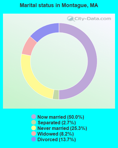
- Never married: 25.3%
- Now married: 50.0%
- Separated: 2.7%
- Widowed: 8.2%
- Divorced: 13.7%
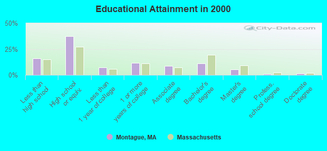
For population 25 years and over in Montague:
- High school or higher: 84.0%
- Bachelor's degree or higher: 19.0%
- Graduate or professional degree: 7.6%
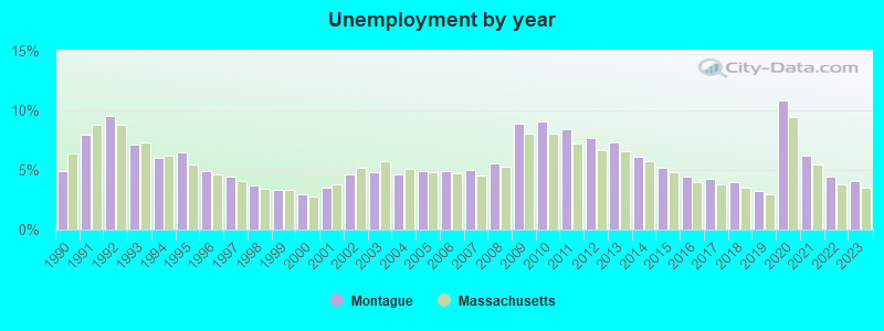
- Unemployed: 5.8%
- Mean travel time to work (commute): 23.0 minutes
| Here: | 11.5 |
| Massachusetts average: | 13.1 |


Graphs represent county-level data. Detailed 2008 Election Results
Religion statistics for Montague, MA (based on Franklin County data)


| Religion | Adherents | Congregations |
|---|---|---|
| Catholic | 16,509 | 15 |
| Mainline Protestant | 4,617 | 38 |
| Evangelical Protestant | 2,079 | 20 |
| Other | 1,580 | 21 |
| None | 46,587 | - |
Food Environment Statistics:
| Franklin County: | 3.63 / 10,000 pop. |
| State: | 1.98 / 10,000 pop. |
| Franklin County: | 0.14 / 10,000 pop. |
| Massachusetts: | 0.05 / 10,000 pop. |
| This county: | 1.67 / 10,000 pop. |
| Massachusetts: | 2.22 / 10,000 pop. |
| Franklin County: | 3.21 / 10,000 pop. |
| Massachusetts: | 1.77 / 10,000 pop. |
| Franklin County: | 8.10 / 10,000 pop. |
| Massachusetts: | 8.76 / 10,000 pop. |
| Franklin County: | 7.5% |
| Massachusetts: | 8.1% |
| Here: | 22.2% |
| Massachusetts: | 22.5% |
| This county: | 15.1% |
| State: | 16.5% |
Strongest AM radio stations in Montague:
- WIZZ (1520 AM; daytime; 10 kW; GREENFIELD, MA; Owner: P. & M. RADIO, LLC)
- WNNZ (640 AM; 50 kW; WESTFIELD, MA; Owner: CLEAR CHANNEL BROADCASTING LICENSES, INC.)
- WHMQ (1240 AM; 1 kW; GREENFIELD, MA; Owner: SAGA COMMUNICATIONS OF NEW ENGLAND, LLC)
- WCRN (830 AM; 50 kW; WORCESTER, MA; Owner: CARTER BROADCASTING CORPORATION)
- WVNE (760 AM; daytime; 25 kW; LEICESTER, MA; Owner: BLOUNT MASSCOM, INC.)
- WCAT (700 AM; daytime; 2 kW; ORANGE-ATHOL, MA; Owner: CITADEL BROADCASTING COMPANY)
- WPNI (1430 AM; 5 kW; AMHERST, MA; Owner: WESTERN MASSACHUSETTS RADIO COMPANY)
- WRKO (680 AM; 50 kW; BOSTON, MA; Owner: ENTERCOM BOSTON LICENSE, LLC)
- WTIC (1080 AM; 50 kW; HARTFORD, CT; Owner: INFINITY RADIO OPERATIONS INC.)
- WEEI (850 AM; 50 kW; BOSTON, MA; Owner: ENTERCOM BOSTON LICENSE, LLC)
- WALE (990 AM; 50 kW; GREENVILLE, RI; Owner: NORTH AMERICAN BROADCASTING CO., INC.)
- WKOX (1200 AM; 50 kW; FRAMINGHAM, MA; Owner: CAPSTAR TX LIMITED PARTNERSHIP)
- WHYN (560 AM; 5 kW; SPRINGFIELD, MA; Owner: CLEAR CHANNEL BROADCASTING LICENSES, INC.)
Strongest FM radio stations in Montague:
- WHAI (98.3 FM; GREENFIELD, MA; Owner: SAGA COMMUNICATIONS OF NEW ENGLAND, LLC)
- WGAJ (91.7 FM; DEERFIELD, MA; Owner: TRUATEES OF DEERFIELD ACADEMY)
- WRSI (93.9 FM; TURNERS FALLS, MA; Owner: GREAT NORTHERN RADIO, LLC)
- WPVQ (95.3 FM; GREENFIELD, MA; Owner: GREAT NORTHERN RADIO, L.L.C.)
- WFCR (88.5 FM; AMHERST, MA; Owner: UNIVERSITY OF MASSACHUSETTS)
- WAMC-FM (90.3 FM; ALBANY, NY; Owner: WAMC)
- WAMH (89.3 FM; AMHERST, MA; Owner: TRUSTEES OF AMHERST COLLEGE)
- WYRY (104.9 FM; HINSDALE, NH; Owner: TRI-VALLEY BROADCASTING CORPORATION)
- WJDF (97.3 FM; ORANGE, MA; Owner: DEANE BROTHERS BROADCASTING CORP.)
- WHYN-FM (93.1 FM; SPRINGFIELD, MA; Owner: CLEAR CHANNEL BROADCASTING LICENSES, INC.)
- W246AM (97.1 FM; AMHERST, MA; Owner: GREAT NORTHERN RADIO, LLC)
- WVAY (100.7 FM; WILMINGTON, VT; Owner: GREAT NORTHERN RADIO, L.L.C.)
- WRNX (100.9 FM; AMHERST, MA; Owner: WESTERN MASSACHUSETTS RADIO COMPANY)
- WEQX (102.7 FM; MANCHESTER, VT; Owner: NORTHSHIRE COMMUNICATIONS, INC.)
- WRSY (101.5 FM; MARLBORO, VT; Owner: GREAT NORTHERN RADIO, L.L.C.)
- WJAN (95.1 FM; SUNDERLAND, VT; Owner: 6 JOHNSON ROAD LICENSES, INC.)
- WOQL (98.7 FM; WINCHESTER, NH; Owner: SAGA COMMUNICATIONS OF NEW HAMPSHIRE, LLC)
- WLZX (99.3 FM; NORTHAMPTON, MA; Owner: SAGA COMMUNICATIONS OF NEW ENGLAND, LLC)
- WFEX (92.1 FM; PETERBOROUGH, NH; Owner: FNX BROADCASTING OF NEW HAMPSHIRE LLC)
- WHDQ (106.1 FM; CLAREMONT, NH; Owner: GREAT NORTHERN RADIO, L.L.C.)
TV broadcast stations around Montague:
- WYDN (Channel 48; WORCESTER, MA; Owner: EDUCATIONAL PUBLIC TV CORPORATION)
- WUNI (Channel 27; WORCESTER, MA; Owner: ENTRAVISION HOLDINGS, LLC)
- W35BK (Channel 35; PLAINFIELD, MA; Owner: LYDIA SYLVANE STOCKWELL)
- National Bridge Inventory (NBI) Statistics
- 18Number of bridges
- 151ft / 45.6mTotal length
- $34,855,000Total costs
- 46,019Total average daily traffic
- 2,729Total average daily truck traffic
- 60,296Total future (year 2031) average daily traffic
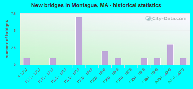
- New bridges - historical statistics
- 1Before 1900
- 11910-1919
- 71930-1939
- 21950-1959
- 11960-1969
- 11980-1989
- 11990-1999
- 32000-2009
- 12010-2019
FCC Registered Antenna Towers:
6- Christopher J Mahoney, Federal Street (Lat: 42.519556 Lon: -72.525611), Type: 48.9, Overall height: 48.9 m, Registrant: National Grid Communications, Inc., Martin.Cohen@gridcom.Com, , Westb-orough, Phone: (508) 389-3000
- Christopher F Ciolfi, Federal Street (Lat: 42.519556 Lon: -72.525611), Type: 48.9, Overall height: 48.9 m, Registrant: National Grid Communications, Inc., Martin.Cohen@gridcom.Com, , Westb-orough, Phone: (508) 389-3000
- Christopher F Ciolfi, Federal Street (Lat: 42.519556 Lon: -72.525611), Type: 48.9, Overall height: 48.9 m, Registrant: National Grid Communications, Inc., Laura.Room@us.Ngridwireless.Com, , Boxbo-rough, Phone: (978) 264-6030
- Edward G Roach, Federal Street (Lat: 42.519556 Lon: -72.525611), Type: 48.9, Overall height: 48.9 m, Registrant: Sba Towers Ii LLC, Eroach@sbasite.Com, , Boca -Raton, Phone: (561) 995-7670
- Edward G Roach, 12 Woodland Dr. (Ma13725-A) (Lat: 42.519556 Lon: -72.525611), Type: 51.8, Structure height: 25011 m, Overall height: 48.5 m, Registrant: Sba Towers Ii LLC, Eroach@sbasite.Com, , Boca -Raton, Phone: (561) 995-7670
- Edward G Roach, 12 Woodland Dr. (Ma13725-A) (Lat: 42.519556 Lon: -72.525611), Type: 51.8, Structure height: 25011 m, Overall height: 48.5 m, Registrant: Sba Towers Ii LLC, Eroach@sbasite.Com, , Boca -Raton, Phone: (561) 995-7670
FCC Registered Broadcast Land Mobile Towers:
4- Cabot Generating Station (Lat: 42.587583 Lon: -72.579250), Call Sign: KCC214, Licensee ID: L00007153,
Assigned Frequencies: 47.9800 MHz, Grant Date: 11/24/1998, Expiration Date: 11/24/2003, Cancellation Date: 07/12/2002, Registrant: Northeast Utilities Service Company, Hartford, CT 06141-0270
- No 1 Gate House Main St Turners Falls (Lat: 42.610083 Lon: -72.554250), Type: Tower, Structure height: 19 m, Call Sign: KTS486,
Assigned Frequencies: 48.0400 MHz, Grant Date: 10/29/2003, Expiration Date: 11/24/2013, Cancellation Date: 01/11/2006, Registrant: Keller And Heckman LLP, 1001 G Street Nw Suite 500 West, Washington, DC 20001, Phone: (202) 434-4130, Fax: (202) 434-4646, Email:
- Cabot Generating Sta (Lat: 42.587583 Lon: -72.579250), Call Sign: WNJQ740,
Assigned Frequencies: 37.6000 MHz, Grant Date: 06/28/2022, Expiration Date: 08/12/2032, Certifier: Stephen Herman, Registrant: Mintz, 555 12th Street, Suite 1100, Washington, DC 20004, Phone: (202) 434-7300, Fax: (202) 434-7400, Email:
- No 1 Gate House Main St Turners Falls (Lat: 42.610083 Lon: -72.554250), Call Sign: WNPL252, Licensee ID: L00007153,
Assigned Frequencies: 37.6000 MHz, Grant Date: 11/24/1998, Expiration Date: 11/24/2003, Cancellation Date: 07/12/2002, Registrant: Northeast Utilities Service Company, Hartford, CT 06141-0270, Phone: (203) 634-5748
FCC Registered Microwave Towers:
5- STATION, Turners Falls (Lat: 42.610639 Lon: -72.553417), Structure height: 6.1 m, Call Sign: WNTQ635,
Assigned Frequencies: 22025.0 MHz, Grant Date: 01/05/2008, Expiration Date: 03/18/2018, Cancellation Date: 05/19/2018, Certifier: Stephen Herman, Registrant: Firstlight Power Resources Services, LLC, 99 Millers Falls Road, Northfield, MA 01360, Phone: (413) 536-9531, Fax: (413) 536-9513, Email:
- CABOT, Cabot Generating Station (Lat: 42.587583 Lon: -72.578972), Type: Bant, Structure height: 18.3 m, Call Sign: WNTT678,
Assigned Frequencies: 6790.00 MHz, 5974.85 MHz, 5974.85 MHz, 5974.85 MHz, 5974.85 MHz, 5974.85 MHz, 5974.85 MHz, 5974.85 MHz, 5974.85 MHz, 5974.85 MHz... (+6 more), Grant Date: 05/17/2019, Expiration Date: 06/23/2029, Certifier: Stephen Herman, Registrant: Mintz, 555 12th Street, Suite 1100, Washington, DC 20004, Phone: (202) 434-7300, Fax: (202) 434-7400, Email:
- COUNTRY HILL, Off Ellis Rd (Lat: 42.561111 Lon: -72.475889), Type: Tower, Structure height: 21.3 m, Call Sign: WPRU301,
Assigned Frequencies: 942.375 MHz, Grant Date: 12/24/2020, Expiration Date: 01/30/2031, Certifier: Richard Hanlon, Registrant: Massachusetts, Commonwealth Of, 470 Worcester Rd, Framingham, MA 01702, Phone: (774) 462-3767, Email:
- COUNTRY HILL, County Hill ( Montague, Ma ) (Lat: 42.560833 Lon: -72.475889), Type: Mast, Structure height: 30 m, Call Sign: WQDV762,
Assigned Frequencies: 10618.7 MHz, Grant Date: 08/12/2015, Expiration Date: 11/09/2025, Certifier: Linda Dunlavy, Registrant: Franklin Regional Council Of Governments, 12 Olive St Ste 2, Greenfield, MA 01301-3351, Phone: (413) 774-3167, Fax: (413) 774-3169, Email:
- COUNTRY HILL, Off Ellis Road (Lat: 42.561111 Lon: -72.475889), Type: Mast, Structure height: 36.6 m, Call Sign: WQNC857,
Assigned Frequencies: 11465.0 MHz, 6256.54 MHz, 6197.24 MHz, 6560.00 MHz, 6226.89 MHz, Grant Date: 09/29/2020, Expiration Date: 12/21/2030, Certifier: Charles B Sutherland, Registrant: Massachusetts, Commonwealth Of, 470 Worcester Rd, Framingham, MA 01702, Phone: (508) 820-2264, Email:
FCC Registered Amateur Radio Licenses:
14 (See the full list of FCC Registered Amateur Radio Licenses in Montague)2002 - 2018 National Fire Incident Reporting System (NFIRS) incidents
- Fire incident types reported to NFIRS in Montague, MA
- 7252.6%Structure Fires
- 5943.1%Outside Fires
- 42.9%Other
- 21.5%Mobile Property/Vehicle Fires
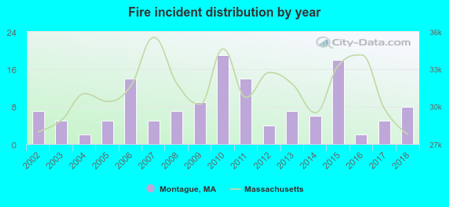 According to the data from the years 2002 - 2018 the average number of fire incidents per year is 8. The highest number of reported fire incidents - 19 took place in 2010, and the least - 2 in 2004. The data has a growing trend.
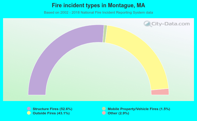 When looking into fire subcategories, the most reports belonged to: Structure Fires (52.6%), and Outside Fires (43.1%).
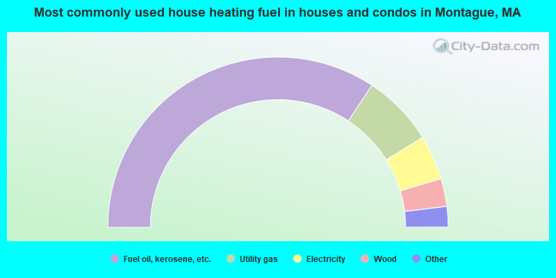
- 68.6%Fuel oil, kerosene, etc.
- 13.7%Utility gas
- 8.5%Electricity
- 5.3%Wood
- 3.6%Bottled, tank, or LP gas
- 0.3%Coal or coke
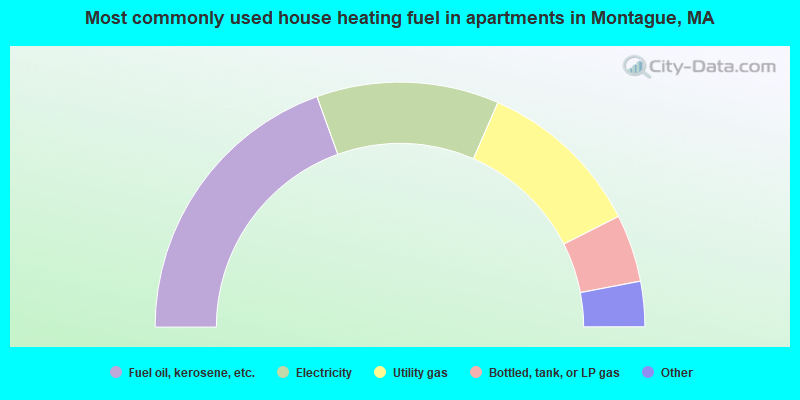
- 39.0%Fuel oil, kerosene, etc.
- 24.1%Electricity
- 22.0%Utility gas
- 8.9%Bottled, tank, or LP gas
- 2.7%Wood
- 1.7%Other fuel
- 1.5%No fuel used
Montague compared to Massachusetts state average:
- Median household income below state average.
- Median house value below state average.
- Unemployed percentage below state average.
- Black race population percentage significantly below state average.
- Hispanic race population percentage below state average.
- Foreign-born population percentage significantly below state average.
- Length of stay since moving in significantly above state average.
- Number of rooms per house significantly below state average.
- House age significantly below state average.
- Percentage of population with a bachelor's degree or higher below state average.
Montague on our top lists:
- #4 on the list of "Top 101 cities with largest percentage of males in occupations: pipelayers, plumbers, pipefitters, and steamfitters (population 5,000+)"
- #11 on the list of "Top 101 cities with largest percentage of males in industries: fuel dealers (population 5,000+)"
- #26 on the list of "Top 101 cities with largest percentage of females in industries: sewing, needlework, and piece goods stores (population 5,000+)"
- #27 on the list of "Top 101 cities with largest percentage of males in industries: miscellaneous manufacturing (population 5,000+)"
- #32 on the list of "Top 101 cities with largest percentage of males in industries: sewing, needlework, and piece goods stores (population 5,000+)"
- #36 on the list of "Top 101 cities with largest percentage of males in industries: private households (population 5,000+)"
- #38 on the list of "Top 101 cities with largest percentage of males in industries: rail transportation (population 5,000+)"
- #46 on the list of "Top 101 cities with the largest percentage of likely lesbian couples (counted as self-reported female-female unmarried-partner households) (population 5,000+)"
- #47 on the list of "Top 101 cities with largest percentage of females in occupations: business operations specialists (population 5,000+)"
- #49 on the list of "Top 101 cities with largest percentage of males in industries: other direct selling establishments (population 5,000+)"
- #54 on the list of "Top 101 cities with largest percentage of males in occupations: other teachers and instructors, education, training, and library occupations (population 5,000+)"
- #56 on the list of "Top 101 cities with largest percentage of males in occupations: food processing workers (population 5,000+)"
- #57 on the list of "Top 101 cities with largest percentage of males in occupations: painters and paperhangers (population 5,000+)"
- #58 on the list of "Top 101 cities with largest percentage of females in occupations: cooks and food preparation workers (population 5,000+)"
- #64 on the list of "Top 101 cities with largest percentage of males in industries: plastics and rubber products (population 5,000+)"
- #74 on the list of "Top 101 cities with largest percentage of males in industries: health and personal care, except drug, stores (population 5,000+)"
- #82 on the list of "Top 101 cities with largest percentage of females in industries: furniture and home furnishings, and household appliance stores (population 5,000+)"
- #85 on the list of "Top 101 cities with largest percentage of males in industries: music stores (population 5,000+)"
- #98 on the list of "Top 101 cities with largest percentage of females in industries: motor vehicles, parts and supplies merchant wholesalers (population 5,000+)"
- #101 on the list of "Top 101 cities with largest percentage of males in industries: book stores and news dealers (population 5,000+)"
- #21 on the list of "Top 101 counties with the highest percentage of residents that drank alcohol in the past 30 days"
- #65 on the list of "Top 101 counties with the lowest average weight of females"
- #84 on the list of "Top 101 counties with the lowest surface withdrawal of fresh water for public supply (pop. 50,000+)"
- #88 on the list of "Top 101 counties with the best general health status score of residents (1-5), 3 years of data"
- #92 on the list of "Top 101 counties with the highest percentage of residents that smoked 100+ cigarettes in their lives"

|
Total of 6 patent applications in 2008-2024.