Rockland, Massachusetts
Submit your own pictures of this town and show them to the world
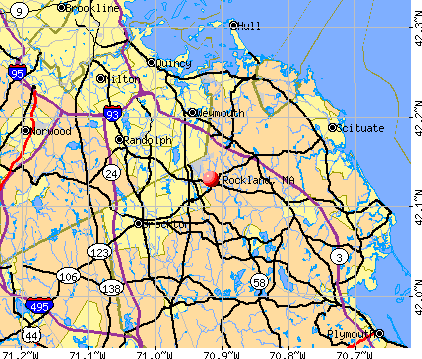
- OSM Map
- General Map
- Google Map
- MSN Map
Population change since 2000: -1.0%
 |
| Males: 8,358 | |
| Females: 9,131 |
| Median resident age: | 40.2 years |
| Massachusetts median age: | 39.2 years |
Zip codes: 02370.
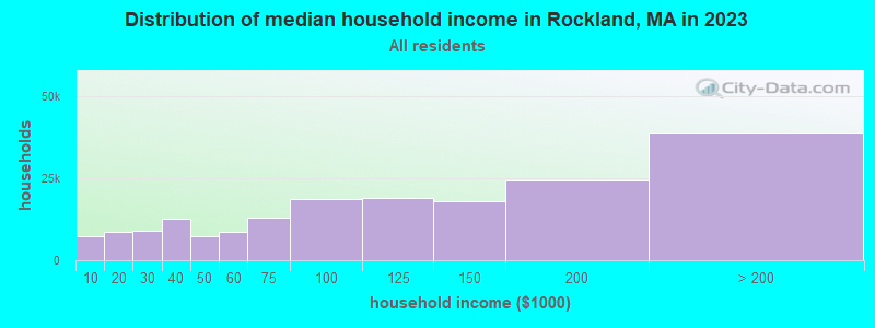
| Rockland: | $93,894 |
| MA: | $94,488 |
Estimated per capita income in 2022: $50,403 (it was $23,068 in 2000)
Rockland town income, earnings, and wages data
Estimated median house or condo value in 2022: $493,918 (it was $158,600 in 2000)
| Rockland: | $493,918 |
| MA: | $534,700 |
Mean prices in 2022: all housing units: $585,203; detached houses: $620,100; townhouses or other attached units: $487,972; in 2-unit structures: $464,355; in 3-to-4-unit structures: $429,583; in 5-or-more-unit structures: $438,441; mobile homes: $207,706; occupied boats, rvs, vans, etc.: $17,153
Detailed information about poverty and poor residents in Rockland, MA


Compare current foreclosures in Rockland, MA:
| Photo | Address | Area | Beds / Baths | Price | Details |
|---|---|---|---|---|---|

|
#1
Woodsbury Rd
Rockland, MA 02370
|
1,176 sq. feet
|
1 baths 3 beds |
show details | |

|
#2
E Water St
Rockland, MA 02370
|
2,368 sq. feet
|
2 baths 4 beds |
show details | |

|
#3
Boxberry Ln
Rockland, MA 02370
|
1,020 sq. feet
|
1 baths 2 beds |
show details | |

|
#4
Birch Bottom Cir
Rockland, MA 02370
|
1,804 sq. feet
|
2 baths 3 beds |
show details | |

|
#5
Boxberry Ln
Rockland, MA 02370
|
1,020 sq. feet
|
1 baths 2 beds |
show details | |

|
#6
Beech St
Rockland, MA 02370
|
864 sq. feet
|
1 baths 4 beds |
show details | |

|
#7
Liberty St
Rockland, MA 02370
|
1,491 sq. feet
|
1 baths 3 beds |
show details | |

|
#8
Eleanor Ln
Rockland, MA 02370
|
1,382 sq. feet
|
1 baths 3 beds |
show details | |

|
#9
Summit St
Rockland, MA 02370
|
2,036 sq. feet
|
2 baths 3 beds |
show details | |

|
#10
Willow Pond Dr
Rockland, MA 02370
|
1,660 sq. feet
|
2 baths 2 beds |
show details |
| Photo | Address | Area | Beds / Baths | Price | Details |
|---|---|---|---|---|---|

|
#11
Eleanor Ln
Rockland, MA 02370
|
1,400 sq. feet
|
1 baths 3 beds |
show details | |

|
#12
Barstow Ln
Rockland, MA 02370
|
2,016 sq. feet
|
2 baths 4 beds |
show details | |

|
#13
North Ave
Rockland, MA 02370
|
957 sq. feet
|
1 baths - beds |
show details | |

|
#14
Pond St
Rockland, MA 02370
|
960 sq. feet
|
1 baths - beds |
show details | |

|
#15
North Ave
Rockland, MA 02370
|
957 sq. feet
|
1 baths - beds |
show details | |

|
#16
Winding Way
Rockland, MA 02370
|
1,130 sq. feet
|
1 baths - beds |
show details | |

|
#17
Myrtle St # 1
Rockland, MA 02370
|
2,080 sq. feet
|
2 baths - beds |
show details | |

|
#18
Concord St
Rockland, MA 02370
|
1,148 sq. feet
|
1 baths - beds |
show details | |

|
#19
Durbeck Rd
Rockland, MA 02370
|
864 sq. feet
|
1 baths - beds |
show details | |

|
#20
Reed St
Rockland, MA 02370
|
1,855 sq. feet
|
1 baths - beds |
show details |
| Photo | Address | Area | Beds / Baths | Price | Details |
|---|---|---|---|---|---|

|
#21
Pond St
Rockland, MA 02370
|
1,260 sq. feet
|
1 baths - beds |
show details | |

|
#22
Pond St
Rockland, MA 02370
|
2,024 sq. feet
|
1 baths - beds |
show details | |

|
#23
Market St
Rockland, MA 02370
|
1,306 sq. feet
|
2 baths - beds |
show details | |

|
#24
Gardner St
Rockland, MA 02370
|
1,719 sq. feet
|
1 baths - beds |
show details | |

|
#25
Centre Ave
Rockland, MA 02370
|
4,224 sq. feet
|
4 baths - beds |
show details | |

|
#26
Old Market St
Rockland, MA 02370
|
1,628 sq. feet
|
1 baths - beds |
show details | |

|
#27
Liberty St
Rockland, MA 02370
|
2,446 sq. feet
|
3 baths - beds |
show details | |

|
#28
Arlington St # A
Rockland, MA 02370
|
3,141 sq. feet
|
4 baths - beds |
show details | |

|
#29
Weymouth St
Rockland, MA 02370
|
- sq. feet
|
- baths - beds |
show details | |

|
#30
North Ave
Rockland, MA 02370
|
- sq. feet
|
- baths - beds |
show details |
| Photo | Address | Area | Beds / Baths | Price | Details |
|---|---|---|---|---|---|

|
#31
Linwood Ter
Rockland, MA 02370
|
- sq. feet
|
- baths - beds |
show details | |

|
#32
Saw Mill Ln
Rockland, MA 02370
|
- sq. feet
|
- baths - beds |
show details | |

|
#33
Hemlock St
Rockland, MA 02370
|
- sq. feet
|
- baths - beds |
show details | |

|
Check over 1 million property listings on Foreclosure.com!
|
browse all offers | |||

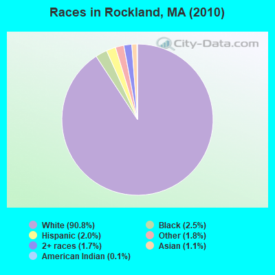
- 15,87990.8%White alone
- 4312.5%Black alone
- 3482.0%Hispanic
- 3081.8%Other race alone
- 3041.7%Two or more races
- 1921.1%Asian alone
- 220.1%American Indian alone
- 50.03%Native Hawaiian and Other
Pacific Islander alone
Races in Rockland detailed stats: ancestries, foreign born residents, place of birth
According to our research of Massachusetts and other state lists, there were 5 registered sex offenders living in Rockland, Massachusetts as of May 19, 2024.
The ratio of all residents to sex offenders in Rockland is 3,498 to 1.
The ratio of registered sex offenders to all residents in this city is lower than the state average.
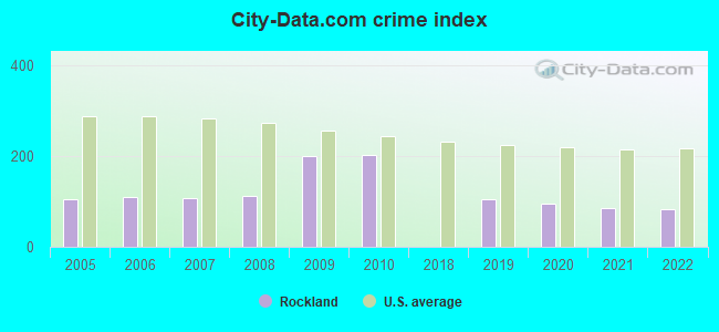
Type |
2009 |
2010 |
2018 |
2019 |
2020 |
2021 |
2022 |
|---|---|---|---|---|---|---|---|
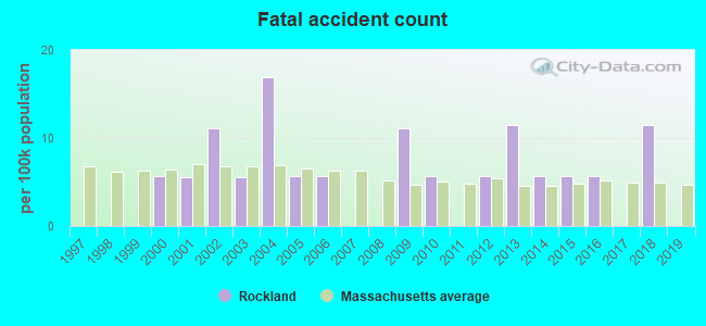
| Murders (per 100,000) | 0 (0.0) | 1 (5.7) | 0 (0.0) | 0 (0.0) | 0 (0.0) | 0 (0.0) | 0 (0.0) |
| Rapes (per 100,000) | 7 (39.0) | 1 (5.7) | 0 (0.0) | 8 (44.7) | 10 (53.6) | 8 (42.3) | 2 (10.8) |
| Robberies (per 100,000) | 13 (72.5) | 13 (74.3) | 0 (0.0) | 4 (22.4) | 1 (5.4) | 1 (5.3) | 0 (0.0) |
| Assaults (per 100,000) | 41 (228.5) | 37 (211.6) | 0 (0.0) | 41 (229.3) | 35 (187.6) | 36 (190.5) | 51 (274.9) |
| Burglaries (per 100,000) | 81 (451.5) | 101 (577.5) | 0 (0.0) | 16 (89.5) | 13 (69.7) | 8 (42.3) | 12 (64.7) |
| Thefts (per 100,000) | 273 (1,522) | 322 (1,841) | 1 (5.5) | 39 (218.1) | 25 (134.0) | 26 (137.6) | 46 (248.0) |
| Auto thefts (per 100,000) | 21 (117.1) | 19 (108.6) | 0 (0.0) | 4 (22.4) | 4 (21.4) | 5 (26.5) | 8 (43.1) |
| Arson (per 100,000) | 0 (0.0) | 0 (0.0) | 0 (0.0) | 3 (16.8) | 0 (0.0) | 1 (5.3) | 0 (0.0) |
| City-Data.com crime index | 200.5 | 203.4 | 0.2 | 105.2 | 94.0 | 84.1 | 81.5 |
The City-Data.com crime index weighs serious crimes and violent crimes more heavily. Higher means more crime, U.S. average is 246.1. It adjusts for the number of visitors and daily workers commuting into cities.
Crime rate in Rockland detailed stats: murders, rapes, robberies, assaults, burglaries, thefts, arson
Full-time law enforcement employees in 2021, including police officers: 36 (33 officers - 32 male; 1 female).
| Officers per 1,000 residents here: | 1.75 |
| Massachusetts average: | 2.53 |
 Recent articles from our blog. Our writers, many of them Ph.D. graduates or candidates, create easy-to-read articles on a wide variety of topics.

 | WFH in MA (243 replies) |
| Congestion Pricing (124 replies) |
| Boston crime thread - all posts go here. (2497 replies) |
| 2021 Real Estate Observations (1729 replies) |
| Is Weymouth on track to be the next Brockton? (42 replies) |
| Is 700k the new 300k? (236 replies) |
Latest news from Rockland, MA collected exclusively by city-data.com from local newspapers, TV, and radio stations
Ancestries: Irish (36.9%), Italian (16.0%), English (15.1%), French (6.4%), United States (5.9%), German (4.7%).
Current Local Time: EST time zone
Incorporated in 1874
Elevation: 140 feet
Land area: 10.0 square miles.
Population density: 1,745 people per square mile (low).
426 residents are foreign born (1.1% Europe, 0.7% Latin America, 0.4% North America).
| This town: | 2.4% |
| Massachusetts: | 12.2% |
| Rockland town: | 1.5% ($2,432) |
| Massachusetts: | 1.3% ($2,336) |
Nearest city with pop. 50,000+: Weymouth, MA  (5.6 miles , pop. 53,988).
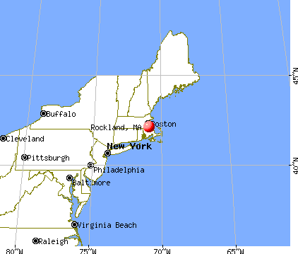
Nearest city with pop. 200,000+: Boston, MA (16.1 miles , pop. 589,141).
Nearest city with pop. 1,000,000+: Bronx, NY (177.2 miles , pop. 1,332,650).
Nearest cities:
), ), )Latitude: 42.13 N, Longitude: 70.91 W
Area codes: 781, 339

Rockland, Massachusetts accommodation & food services, waste management - Economy and Business Data
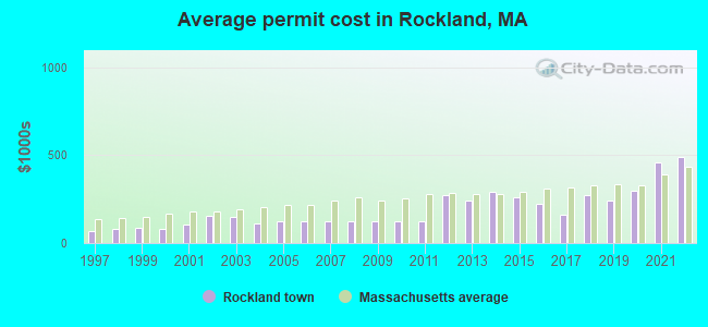
Single-family new house construction building permits:
- 2022: 1 building, cost: $488,400
- 2021: 1 building, cost: $458,000
- 2020: 2 buildings, average cost: $300,400
- 2019: 3 buildings, average cost: $241,700
- 2018: 5 buildings, average cost: $276,000
- 2017: 4 buildings, average cost: $162,200
- 2016: 4 buildings, average cost: $225,000
- 2015: 11 buildings, average cost: $258,600
- 2014: 23 buildings, average cost: $289,100
- 2013: 20 buildings, average cost: $245,000
- 2012: 6 buildings, average cost: $272,200
- 2011: 23 buildings, average cost: $122,700
- 2010: 29 buildings, average cost: $122,700
- 2009: 28 buildings, average cost: $122,700
- 2008: 35 buildings, average cost: $122,600
- 2007: 57 buildings, average cost: $122,700
- 2006: 67 buildings, average cost: $122,500
- 2005: 99 buildings, average cost: $123,300
- 2004: 39 buildings, average cost: $111,900
- 2003: 7 buildings, average cost: $149,300
- 2002: 8 buildings, average cost: $156,600
- 2001: 32 buildings, average cost: $108,000
- 2000: 30 buildings, average cost: $81,900
- 1999: 37 buildings, average cost: $87,100
- 1998: 79 buildings, average cost: $77,800
- 1997: 55 buildings, average cost: $71,400

| Here: | 3.5% |
| Massachusetts: | 3.5% |
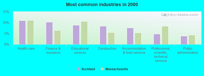
- Health care (11.0%)
- Finance & insurance (10.2%)
- Educational services (8.8%)
- Construction (8.4%)
- Accommodation & food services (7.5%)
- Professional, scientific, technical services (4.8%)
- Public administration (3.9%)
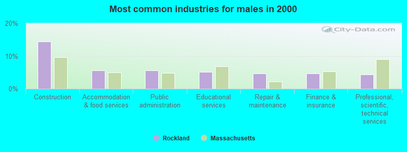
- Construction (14.5%)
- Accommodation & food services (5.6%)
- Public administration (5.6%)
- Educational services (5.1%)
- Repair & maintenance (4.7%)
- Finance & insurance (4.6%)
- Professional, scientific, technical services (4.3%)
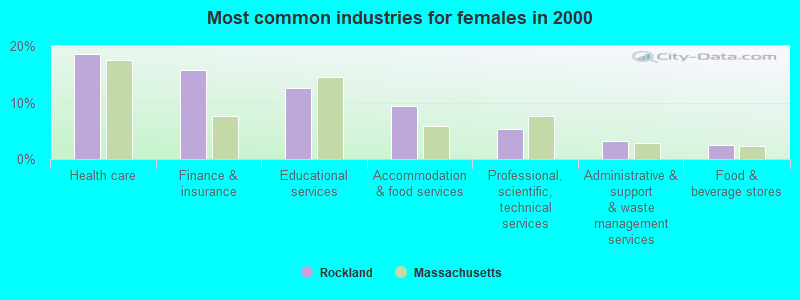
- Health care (18.5%)
- Finance & insurance (15.8%)
- Educational services (12.5%)
- Accommodation & food services (9.4%)
- Professional, scientific, technical services (5.4%)
- Administrative & support & waste management services (3.2%)
- Food & beverage stores (2.5%)
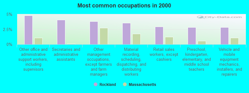
- Other office and administrative support workers, including supervisors (4.8%)
- Secretaries and administrative assistants (4.1%)
- Other management occupations, except farmers and farm managers (3.8%)
- Material recording, scheduling, dispatching, and distributing workers (3.5%)
- Retail sales workers, except cashiers (2.9%)
- Preschool, kindergarten, elementary, and middle school teachers (2.8%)
- Vehicle and mobile equipment mechanics, installers, and repairers (2.8%)
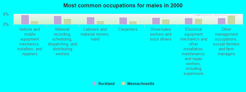
- Vehicle and mobile equipment mechanics, installers, and repairers (5.6%)
- Material recording, scheduling, dispatching, and distributing workers (5.1%)
- Laborers and material movers, hand (4.3%)
- Carpenters (4.2%)
- Driver/sales workers and truck drivers (4.0%)
- Electrical equipment mechanics and other installation, maintenance, and repair workers, including supervisors (3.9%)
- Other management occupations, except farmers and farm managers (3.8%)
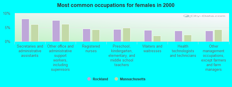
- Secretaries and administrative assistants (8.0%)
- Other office and administrative support workers, including supervisors (7.5%)
- Registered nurses (4.6%)
- Preschool, kindergarten, elementary, and middle school teachers (4.3%)
- Waiters and waitresses (4.0%)
- Health technologists and technicians (3.8%)
- Other management occupations, except farmers and farm managers (3.8%)
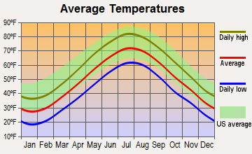
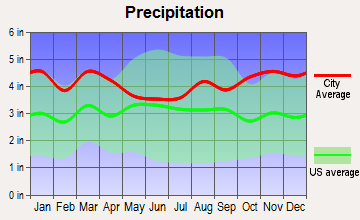
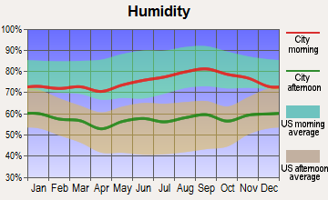
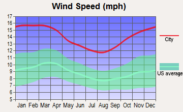
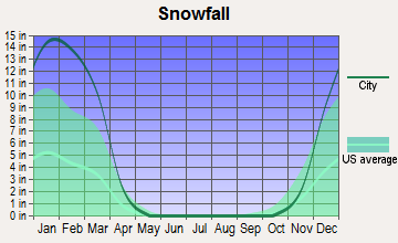
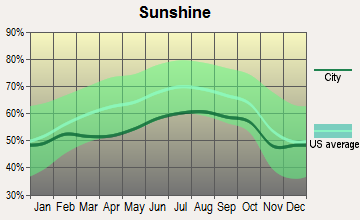
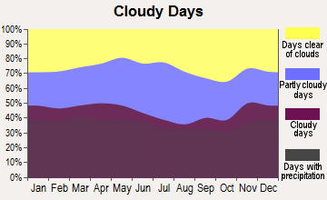
Average climate in Rockland, Massachusetts
Based on data reported by over 4,000 weather stations
(lower is better)
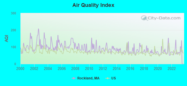
Air Quality Index (AQI) level in 2022 was 74.3. This is about average.
| City: | 74.3 |
| U.S.: | 72.6 |
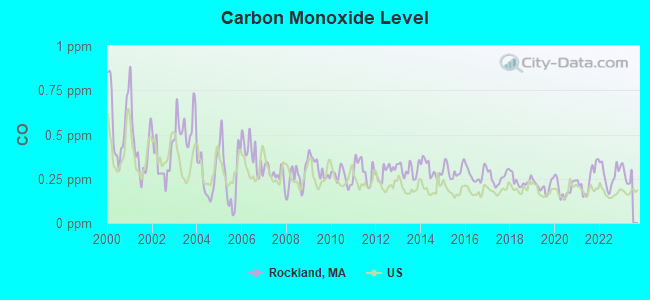
Carbon Monoxide (CO) [ppm] level in 2022 was 0.270. This is about average. Closest monitor was 8.5 miles away from the city center.
| City: | 0.270 |
| U.S.: | 0.251 |
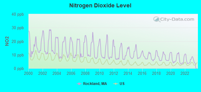
Nitrogen Dioxide (NO2) [ppb] level in 2022 was 6.09. This is about average. Closest monitor was 8.2 miles away from the city center.
| City: | 6.09 |
| U.S.: | 5.11 |
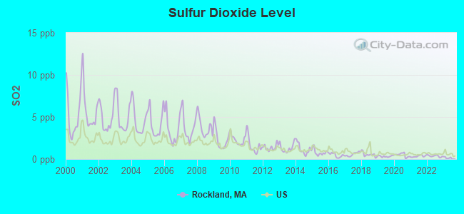
Sulfur Dioxide (SO2) [ppb] level in 2022 was 0.358. This is significantly better than average. Closest monitor was 6.3 miles away from the city center.
| City: | 0.358 |
| U.S.: | 1.515 |
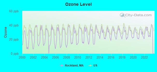
Ozone [ppb] level in 2022 was 30.3. This is about average. Closest monitor was 6.8 miles away from the city center.
| City: | 30.3 |
| U.S.: | 33.3 |
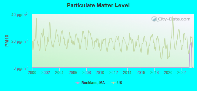
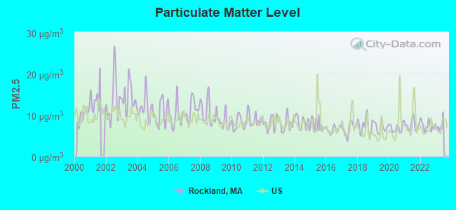
Particulate Matter (PM2.5) [µg/m3] level in 2022 was 7.37. This is about average. Closest monitor was 6.2 miles away from the city center.
| City: | 7.37 |
| U.S.: | 8.11 |
Tornado activity:
Rockland-area historical tornado activity is slightly below Massachusetts state average. It is 56% smaller than the overall U.S. average.
On 6/9/1953, a category F4 (max. wind speeds 207-260 mph) tornado 33.3 miles away from the Rockland town center killed 90 people and injured 1228 people and caused between $50,000,000 and $500,000,000 in damages.
On 6/9/1953, a category F3 (max. wind speeds 158-206 mph) tornado 15.8 miles away from the town center injured 17 people and caused between $500,000 and $5,000,000 in damages.
Earthquake activity:
Rockland-area historical earthquake activity is significantly above Massachusetts state average. It is 74% smaller than the overall U.S. average.On 10/7/1983 at 10:18:46, a magnitude 5.3 (5.1 MB, 5.3 LG, 5.1 ML, Class: Moderate, Intensity: VI - VII) earthquake occurred 214.4 miles away from Rockland center
On 4/20/2002 at 10:50:47, a magnitude 5.3 (5.3 ML, Depth: 3.0 mi) earthquake occurred 216.3 miles away from the city center
On 1/19/1982 at 00:14:42, a magnitude 4.7 (4.5 MB, 4.7 MD, 4.5 LG, Class: Light, Intensity: IV - V) earthquake occurred 101.0 miles away from the city center
On 10/16/2012 at 23:12:25, a magnitude 4.7 (4.7 ML, Depth: 10.0 mi) earthquake occurred 102.4 miles away from the city center
On 4/20/2002 at 10:50:47, a magnitude 5.2 (5.2 MB, 4.2 MS, 5.2 MW, 5.0 MW) earthquake occurred 215.7 miles away from the city center
On 8/22/1992 at 12:20:32, a magnitude 4.8 (4.8 MB, 3.8 MS, 4.7 LG, Depth: 6.2 mi) earthquake occurred 211.4 miles away from Rockland center
Magnitude types: regional Lg-wave magnitude (LG), body-wave magnitude (MB), duration magnitude (MD), local magnitude (ML), surface-wave magnitude (MS), moment magnitude (MW)
Natural disasters:
The number of natural disasters in Plymouth County (26) is a lot greater than the US average (15).Major Disasters (Presidential) Declared: 17
Emergencies Declared: 9
Causes of natural disasters: Floods: 11, Storms: 9, Hurricanes: 7, Snows: 3, Snowstorms: 3, Blizzards: 2, Winter Storms: 2, Heavy Rain: 1, Snowfall: 1, Tropical Storm: 1, Wind: 1 (Note: some incidents may be assigned to more than one category).
Main business address for: INDEPENDENT BANK CORP (STATE COMMERCIAL BANKS), BIOSPHERE MEDICAL INC (PHARMACEUTICAL PREPARATIONS).
Hospitals and medical centers in Rockland:
- AFFILIATED COMMUNITY VNA INC (200 LEDGEWOOD PLACE)
- COYNE HEALTHCARE CENTER (56 WEBSTER STREET)
- DEL-MANOR N H (54 WEBSTER ST)
- LINDEN NURSING AND RET HOME (167 W WATER ST)
- ROCKLAND NURSING HOME (384 UNION ST)
- SOUTH SHORE NURSING FACILITY (115 NORTH AVENUE)
- SOUTHSHORE HEALTH CARE CENTER (115 NORTH AVENUE)
Amtrak stations near Rockland:
- 14 miles: ROUTE 128 (WESTWOOD, UNIVERSITY AVE. & RTE. 128) . Services: ticket office, enclosed waiting area, public restrooms, public payphones, vending machines, paid short-term parking, taxi stand, public transit connection.
- 18 miles: BOSTON (SO. STA) (BOSTON, ATLANTIC AVE. & SUMMER ST.) . Services: ticket office, fully wheelchair accessible, enclosed waiting area, public restrooms, public payphones, full-service food facilities and snack bar, ATM, paid short-term parking, paid long-term parking, call for car rental service, taxi stand, intercity bus service, public transit connection.
- 18 miles: BACK BAY (BOSTON, 145 DARTMOUTH ST.) . Services: ticket office, partially wheelchair accessible, enclosed waiting area, public restrooms, public payphones, vending machines, ATM, paid short-term parking, paid long-term parking, call for car rental service, taxi stand, public transit connection.
Operable nuclear power plant near Rockland:
- 18 miles: Pilgrim in Plymouth, MA.
Colleges/universities with over 2000 students nearest to Rockland:
- Massasoit Community College (about 6 miles; Brockton, MA; Full-time enrollment: 5,442)
- Quincy College (about 10 miles; Quincy, MA; FT enrollment: 3,184)
- Stonehill College (about 10 miles; Easton, MA; FT enrollment: 2,563)
- Bridgewater State University (about 11 miles; Bridgewater, MA; FT enrollment: 9,802)
- Curry College (about 13 miles; Milton, MA; FT enrollment: 2,586)
- University of Massachusetts-Boston (about 15 miles; Boston, MA; FT enrollment: 12,625)
- Wentworth Institute of Technology (about 18 miles; Boston, MA; FT enrollment: 4,418)
Public high school in Rockland:
- ROCKLAND SENIOR HIGH (Students: 753, Location: 52 MACKINLAY WAY, Grades: PK-12)
Private high school in Rockland:
Public elementary/middle schools in Rockland:
- JOHN W ROGERS MIDDLE (Students: 615, Location: 100 TAUNTON AVENUE, Grades: 5-8)
- R STEWART ESTEN (Students: 411, Location: 733 SUMMER STREET, Grades: 1-4)
- JEFFERSON ELEMENTARY SCHOOL (Students: 393, Location: 93 GEORGE STREET, Grades: KG-4)
- MEMORIAL PARK (Students: 352, Location: 1 COL BRIAN DUFFY WAY, Grades: 1-4)
Private elementary/middle school in Rockland:
Points of interest:
Notable locations in Rockland: Rockland Plaza (A), Rockland Golf Course (B), Rockland Fire Department (C), Rockland Memorial Library (D), Rockland Town Hall (E). Display/hide their locations on the map
Main business address in Rockland include: INDEPENDENT BANK CORP (A), BIOSPHERE MEDICAL INC (B). Display/hide their locations on the map
Churches in Rockland include: Trinity Episcopal Church (A), Hatherly United Methodist Church (B), First Congregational Church (C), First Church of Christ Scientist (D), First Baptist Church of Rockland (E), Channing Unitarian Church (F). Display/hide their locations on the map
Cemeteries: Mount Pleasant Cemetery (1), Beal Cemetery (2), Maplewood Cemetery (3), Holy Family Cemetery (4), Saint Patricks Cemetery (5). Display/hide their locations on the map
Reservoirs and swamps: Studleys Pond (A), Beech Hill Swamp (B). Display/hide their locations on the map
Park in Rockland: Lower Union Street Historic District (1). Display/hide its location on the map
Tourist attraction: Country Rentals (Arcades & Amusements; 20 Spring Street).
Hotels: Holiday Inn Rockland Massachusetts (909 Hingham St), Comfort Inn Rockland (850 Hingham Street), Radisson-Rockland (929 Hingham Street), Radisson Hotel-Rockland-Grand Ballroom (929 Hingham Street).
Birthplace of: John H. Flavell - Psychologist, Jonathan Togo - Actor, John R. Buckley - Member of the Massachusetts House of Representatives, PJ Ladd - Skateboarder.
Drinking water stations with addresses in Rockland and their reported violations in the past:
ABINGTON/ROCKLAND JOINT WTR. WORKS (Population served: 33,455, Surface water):Past health violations:TEDESCHI FOOD SHOP (Serves NH, Population served: 70, Groundwater):
- MCL, Average - Between APR-2014 and JUN-2014, Contaminant: Total Haloacetic Acids (HAA5). Follow-up actions: St AO (w/o penalty) issued (AUG-26-2014)
- MCL, Monthly (TCR) - In JUN-2011, Contaminant: Coliform. Follow-up actions: St AO (w/o penalty) issued (AUG-30-2011)
- MCL, Monthly (TCR) - In OCT-2010, Contaminant: Coliform. Follow-up actions: St AO (w/o penalty) issued (FEB-10-2011), St Compliance achieved (FEB-10-2011)
Past monitoring violations:
- 5 routine major monitoring violations
| This town: | 2.6 people |
| Massachusetts: | 2.5 people |
| This town: | 66.7% |
| Whole state: | 63.0% |
| This town: | 7.7% |
| Whole state: | 7.0% |
Likely homosexual households (counted as self-reported same-sex unmarried-partner households)
- Lesbian couples: 0.5% of all households
- Gay men: 0.4% of all households
| This town: | 6.8% |
| Whole state: | 9.3% |
| This town: | 3.0% |
| Whole state: | 4.4% |
People in group quarters in Rockland in 2010:
- 188 people in nursing facilities/skilled-nursing facilities
- 26 people in group homes intended for adults
- 11 people in emergency and transitional shelters (with sleeping facilities) for people experiencing homelessness
- 3 people in other noninstitutional facilities
People in group quarters in Rockland in 2000:
- 170 people in nursing homes
- 12 people in religious group quarters
- 9 people in homes or halfway houses for drug/alcohol abuse
Banks with branches in Rockland (2011 data):
- South Coastal Bank: at 279 Union Street, branch established on 1868/03/30. Info updated 2010/07/20: Bank assets: $268.5 mil, Deposits: $207.0 mil, local headquarters, positive income, Commercial Lending Specialization, 3 total offices, Holding Company: Mountainone Financial Partners, Mhc
- Rockland Trust Company: at 288 Union Street, branch established on 1907/09/10. Info updated 2009/05/20: Bank assets: $4,974.4 mil, Deposits: $3,903.9 mil, local headquarters, positive income, Commercial Lending Specialization, 67 total offices, Holding Company: Independent Bank Corp.
For population 15 years and over in Rockland:
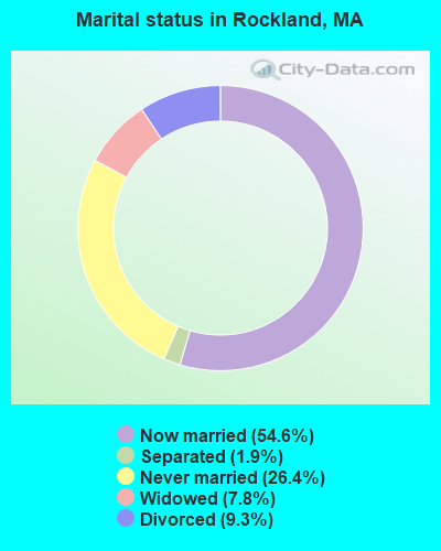
- Never married: 26.4%
- Now married: 54.6%
- Separated: 1.9%
- Widowed: 7.8%
- Divorced: 9.3%
For population 25 years and over in Rockland:
- High school or higher: 88.6%
- Bachelor's degree or higher: 18.2%
- Graduate or professional degree: 4.7%
- Unemployed: 2.9%
- Mean travel time to work (commute): 29.5 minutes
| Here: | 8.6 |
| Massachusetts average: | 13.1 |


Graphs represent county-level data. Detailed 2008 Election Results
Religion statistics for Rockland, MA (based on Plymouth County data)


| Religion | Adherents | Congregations |
|---|---|---|
| Catholic | 165,985 | 35 |
| Mainline Protestant | 23,724 | 91 |
| Evangelical Protestant | 13,159 | 96 |
| Other | 6,129 | 43 |
| Orthodox | 1,140 | 3 |
| Black Protestant | 611 | 5 |
| None | 284,171 | - |
Food Environment Statistics:
| This county: | 1.74 / 10,000 pop. |
| Massachusetts: | 1.98 / 10,000 pop. |
| Plymouth County: | 0.04 / 10,000 pop. |
| Massachusetts: | 0.05 / 10,000 pop. |
| Here: | 2.84 / 10,000 pop. |
| State: | 2.22 / 10,000 pop. |
| This county: | 2.20 / 10,000 pop. |
| Massachusetts: | 1.77 / 10,000 pop. |
| This county: | 7.37 / 10,000 pop. |
| State: | 8.76 / 10,000 pop. |
| Plymouth County: | 7.9% |
| Massachusetts: | 8.1% |
| Here: | 21.7% |
| Massachusetts: | 22.5% |
| Plymouth County: | 16.3% |
| Massachusetts: | 16.5% |
5.54% of this county's 2020 resident taxpayers moved to other counties in 2021 ($85,482 average adjusted gross income)
| Here: | 5.54% |
| Massachusetts average: | 7.18% |
0.01% of residents moved to foreign countries ($80 average AGI)
Plymouth County: 0.01% Massachusetts average: 0.02%
Top counties to which taxpayers relocated from this county between 2020 and 2021:
| to Bristol County, MA | |
| to Norfolk County, MA | |
| to Suffolk County, MA |
| Businesses in Rockland, MA | ||||
| Name | Count | Name | Count | |
|---|---|---|---|---|
| 7-Eleven | 1 | GNC | 1 | |
| AutoZone | 1 | H&R Block | 1 | |
| Best Western | 1 | Holiday Inn | 1 | |
| Burger King | 2 | Home Depot | 1 | |
| CVS | 1 | Lane Furniture | 1 | |
| Circle K | 1 | MasterBrand Cabinets | 3 | |
| Comfort Inn | 1 | McDonald's | 1 | |
| Domino's Pizza | 1 | Rite Aid | 1 | |
| Dunkin Donuts | 4 | UPS | 5 | |
| FedEx | 5 | Walgreens | 1 | |
Strongest AM radio stations in Rockland:
- WBZ (1030 AM; 50 kW; BOSTON, MA; Owner: INFINITY BROADCASTING OPERATIONS, INC.)
- WEEI (850 AM; 50 kW; BOSTON, MA; Owner: ENTERCOM BOSTON LICENSE, LLC)
- WRKO (680 AM; 50 kW; BOSTON, MA; Owner: ENTERCOM BOSTON LICENSE, LLC)
- WWZN (1510 AM; 50 kW; BOSTON, MA; Owner: ROSE CITY RADIO CORPORATION)
- WKOX (1200 AM; 50 kW; FRAMINGHAM, MA; Owner: CAPSTAR TX LIMITED PARTNERSHIP)
- WBIX (1060 AM; 40 kW; NATICK, MA; Owner: LANGER BROADCASTING CORPORATION)
- WBET (1460 AM; 5 kW; BROCKTON, MA; Owner: KJI BROADCASTING, LLC)
- WUNR (1600 AM; 20 kW; BROOKLINE, MA; Owner: CHAMPION BROADCASTING SYSTEMS, INC.)
- WALE (990 AM; 50 kW; GREENVILLE, RI; Owner: NORTH AMERICAN BROADCASTING CO., INC.)
- WAMG (890 AM; 25 kW; DEDHAM, MA; Owner: MEGA COMMUNICATIONS OF DEDHAM LICENSEE, LLC)
- WRCA (1330 AM; 25 kW; WALTHAM, MA; Owner: WRCA LICENSE, LLC)
- WMKI (1260 AM; 5 kW; BOSTON, MA; Owner: ABC, INC.)
- WCRN (830 AM; 50 kW; WORCESTER, MA; Owner: CARTER BROADCASTING CORPORATION)
Strongest FM radio stations in Rockland:
- WRPS (88.3 FM; ROCKLAND, MA; Owner: ROCKLAND PUBLIC SCHOOLS)
- WXKS-FM (107.9 FM; MEDFORD, MA; Owner: AMFM RADIO LICENSES, L.L.C.)
- WMJX (106.7 FM; BOSTON, MA; Owner: GREATER BOSTON RADIO, INC.)
- WBOT (97.7 FM; BROCKTON, MA; Owner: RADIO ONE LICENSES, LLC)
- WBMX (98.5 FM; BOSTON, MA; Owner: INFINITY RADIO OPERATIONS INC.)
- WBOS (92.9 FM; BROOKLINE, MA; Owner: GREATER BOSTON RADIO, INC.)
- WJMN (94.5 FM; BOSTON, MA; Owner: AMFM RADIO LICENSES, L.L.C.)
- WCRB (102.5 FM; WALTHAM, MA; Owner: CHARLES RIVER BROADCASTING WCRB LICE)
- WTKK (96.9 FM; BOSTON, MA; Owner: GREATER BOSTON RADIO, INC.)
- WROR-FM (105.7 FM; FRAMINGHAM, MA; Owner: GREATER BOSTON RADIO, INC.)
- WATD-FM (95.9 FM; MARSHFIELD, MA; Owner: MARSHFIELD BROADCASTING CO., INC.)
- WGBH (89.7 FM; BOSTON, MA; Owner: WGBH EDUCATIONAL FOUNDATION)
- WBUR-FM (90.9 FM; BOSTON, MA; Owner: TRUSTEES OF BOSTON UNIVERSITY)
- WBCN (104.1 FM; BOSTON, MA; Owner: HEMISPHERE BROADCASTING CORPORATION)
- WZLX (100.7 FM; BOSTON, MA; Owner: INFINITY BROADCASTING CORPORATION OF BOSTON)
- W267AI (101.3 FM; BOSTON, MA; Owner: MCC BROADCASTING COMPANY, INC.)
- WERS (88.9 FM; BOSTON, MA; Owner: EMERSON COLLEGE)
- WODS (103.3 FM; BOSTON, MA; Owner: INFINITY BROADCASTING OPERATIONS, INC.)
- WHRB (95.3 FM; CAMBRIDGE, MA; Owner: HARVARD RADIO BROADCASTING CO., INC.)
- WWBB (101.5 FM; PROVIDENCE, RI; Owner: CLEAR CHANNEL BROADCASTING LICENSES, INC.)
TV broadcast stations around Rockland:
- WWDP (Channel 46; NORWELL, MA; Owner: NORWELL TELEVISION, LLC)
- WCVB-TV (Channel 5; BOSTON, MA; Owner: WCVB HEARST-ARGYLE TV, INC.)
- WGBH-TV (Channel 2; BOSTON, MA; Owner: WGBH EDUCATIONAL FOUNDATION)
- WHDH-TV (Channel 7; BOSTON, MA; Owner: WHDH-TV)
- WMFP (Channel 62; LAWRENCE, MA; Owner: WSAH LICENSE, INC.)
- WSBK-TV (Channel 38; BOSTON, MA; Owner: VIACOM INC.)
- WLVI-TV (Channel 56; CAMBRIDGE, MA; Owner: WLVI, INC.)
- WBZ-TV (Channel 4; BOSTON, MA; Owner: VIACOM INC.)
- WGBX-TV (Channel 44; BOSTON, MA; Owner: WGBH EDUCATIONAL FOUNDATION)
- WBPX (Channel 68; BOSTON, MA; Owner: PAXSON BOSTON-68 LICENSE, INC.)
- WFXT (Channel 25; BOSTON, MA; Owner: FOX TELEVISION STATIONS INC.)
- WTMU-LP (Channel 32; BOSTON, MA; Owner: ZGS BOSTON, INC.)
- WCEA-LP (Channel 58; BOSTON, MA; Owner: CHANNEL 19 TV CORPORATION)
- W40BO (Channel 40; BOSTON, MA; Owner: PAXSON COMMUNICATIONS LPTV, INC.)
- WLNE-TV (Channel 6; NEW BEDFORD, MA; Owner: FREEDOM BROADCASTING OF SOUTHERN NEW ENGLAND, INC.)
- WPRI-TV (Channel 12; PROVIDENCE, RI; Owner: TVL BROADCASTING OF RHODE ISLAND, LLC)
- WNAC-TV (Channel 64; PROVIDENCE, RI; Owner: WNAC, LLC)
- WUTF (Channel 66; MARLBOROUGH, MA; Owner: TELEFUTURA BOSTON LLC)
- WJAR (Channel 10; PROVIDENCE, RI; Owner: OUTLET BROADCASTING, INC.)
- WLWC (Channel 28; NEW BEDFORD, MA; Owner: C-28 FCC LICENSEE SUBSIDIARY, LLC)
- WSBE-TV (Channel 36; PROVIDENCE, RI; Owner: RHODE ISLAND PUBLIC TELECOM. AUTHORITY)
- WUNI (Channel 27; WORCESTER, MA; Owner: ENTRAVISION HOLDINGS, LLC)
- National Bridge Inventory (NBI) Statistics
- 5Number of bridges
- 43ft / 13.3mTotal length
- $9,739,000Total costs
- 164,293Total average daily traffic
- 10,052Total average daily truck traffic
- 247,160Total future (year 2030) average daily traffic
FCC Registered Antenna Towers: 44 (See the full list of FCC Registered Antenna Towers)
FCC Registered Broadcast Land Mobile Towers: 14 (See the full list of FCC Registered Broadcast Land Mobile Towers in Rockland, MA)
FCC Registered Microwave Towers: 13 (See the full list of FCC Registered Microwave Towers in this town)
FCC Registered Paging Towers: 1 (See the full list of FCC Registered Paging Towers)
FCC Registered Amateur Radio Licenses: 55 (See the full list of FCC Registered Amateur Radio Licenses in Rockland)
FAA Registered Aircraft Manufacturers and Dealers: 6 (See the full list of FAA Registered Manufacturers and Dealers in Rockland)
FAA Registered Aircraft: 6 (See the full list of FAA Registered Aircraft)
2002 - 2018 National Fire Incident Reporting System (NFIRS) incidents
- Fire incident types reported to NFIRS in Rockland, MA
- 44746.3%Structure Fires
- 33434.6%Outside Fires
- 11211.6%Mobile Property/Vehicle Fires
- 727.5%Other
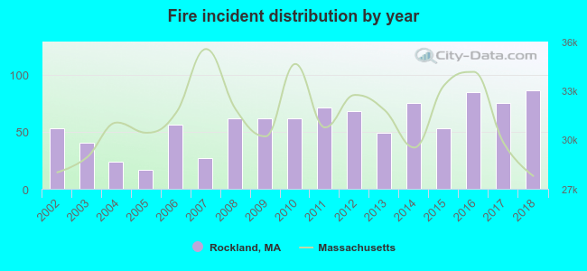 According to the data from the years 2002 - 2018 the average number of fires per year is 57. The highest number of fires - 86 took place in 2018, and the least - 17 in 2005. The data has a growing trend.
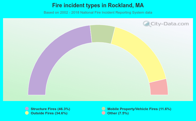 When looking into fire subcategories, the most reports belonged to: Structure Fires (46.3%), and Outside Fires (34.6%).
Fire-safe hotels and motels in Rockland, Massachusetts:
- Best Western Rockland Inn, 909 Hingham St, Rockland, Massachusetts 02370 , Phone: (781) 871-5660, Fax: (781) 871-7255
- Radisson Hotel Rockland, 929 Hingham St, Rockland, Massachusetts 02370 , Phone: (781) 871-0545, Fax: (781) 792-2873
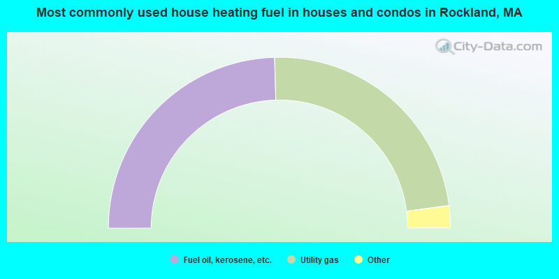
- 49.1%Fuel oil, kerosene, etc.
- 46.7%Utility gas
- 3.1%Electricity
- 1.1%Bottled, tank, or LP gas
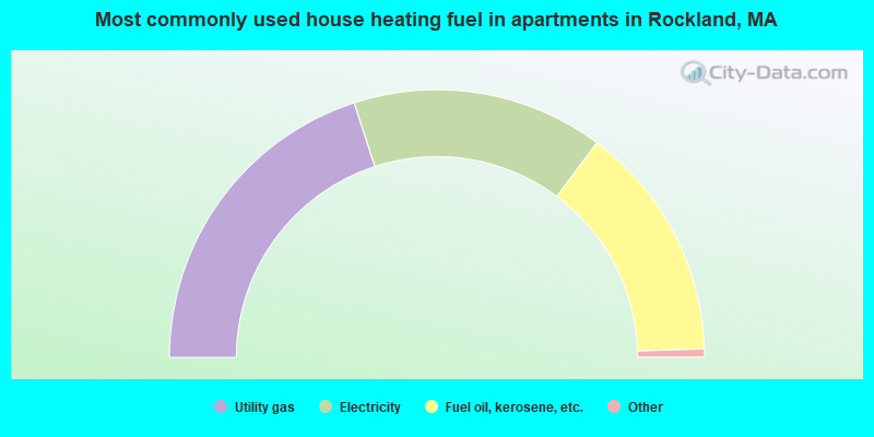
- 40.0%Utility gas
- 30.4%Electricity
- 28.6%Fuel oil, kerosene, etc.
- 0.6%Other fuel
- 0.4%Bottled, tank, or LP gas
Rockland compared to Massachusetts state average:
- Unemployed percentage significantly below state average.
- Black race population percentage below state average.
- Hispanic race population percentage significantly below state average.
- Foreign-born population percentage significantly below state average.
- Length of stay since moving in significantly above state average.
- Number of rooms per house significantly below state average.
- House age significantly below state average.
- Percentage of population with a bachelor's degree or higher below state average.
Rockland on our top lists:
- #13 on the list of "Top 101 cities with largest percentage of males in industries: u. s. postal service (population 5,000+)"
- #29 on the list of "Top 101 cities with largest percentage of males in industries: personal and laundry services (population 5,000+)"
- #37 on the list of "Top 101 cities with largest percentage of females in occupations: printing workers (population 5,000+)"
- #40 on the list of "Top 101 cities with largest percentage of females in industries: electronic shopping and mail-order houses (population 5,000+)"
- #41 on the list of "Top 101 cities with largest percentage of males in industries: electrical and electronic goods merchant wholesalers (population 5,000+)"
- #50 on the list of "Top 101 cities with largest percentage of males in occupations: art and design workers (population 5,000+)"
- #50 on the list of "Top 101 cities with largest percentage of males in occupations: special education teachers (population 5,000+)"
- #56 on the list of "Top 101 cities with largest percentage of males in industries: furniture and home furnishing merchant wholesalers (population 5,000+)"
- #63 on the list of "Top 101 cities with largest percentage of females in occupations: food and beverage serving workers except waiters/waitresses (population 5,000+)"
- #65 on the list of "Top 101 cities with largest percentage of females in industries: furniture and home furnishings, and household appliance stores (population 5,000+)"
- #67 on the list of "Top 101 cities with largest percentage of females in industries: fuel dealers (population 5,000+)"
- #70 on the list of "Top 101 cities with largest percentage of females in industries: finance and insurance (population 5,000+)"
- #72 on the list of "Top 101 cities with largest percentage of females in occupations: carpenters (population 5,000+)"
- #75 on the list of "Top 101 cities with largest percentage of males in industries: furniture and home furnishings, and household appliance stores (population 5,000+)"
- #76 on the list of "Top 101 cities with largest percentage of females in industries: clothing and accessories, including shoe, stores (population 5,000+)"
- #77 on the list of "Top 101 cities with largest percentage of females in industries: motor vehicles, parts and supplies merchant wholesalers (population 5,000+)"
- #79 on the list of "Top 101 cities with largest percentage of males in industries: retail florists (population 5,000+)"
- #80 on the list of "Top 101 cities with largest percentage of males in occupations: personal appearance workers (population 5,000+)"
- #87 on the list of "Top 101 cities with largest percentage of females in industries: drugs, sundries, and chemical and allied products merchant wholesalers (population 5,000+)"
- #88 on the list of "Top 101 cities with largest percentage of males in industries: pharmacies and drug stores (population 5,000+)"
- #92 (02370) on the list of "Top 101 zip codes with the largest percentage of Irish first ancestries (pop 5,000+)"
- #18 on the list of "Top 101 counties with the highest percentage of residents that visited a dentist within the past year"
- #24 on the list of "Top 101 counties with the highest percentage of residents that smoked 100+ cigarettes in their lives"
- #35 on the list of "Top 101 counties with the largest decrease in the number of births per 1000 residents 2000-2006 to 2007-2013 (pop 50,000+)"
- #39 on the list of "Top 101 counties with the lowest percentage of residents that keep firearms around their homes"
- #39 on the list of "Top 101 counties with the lowest number of infant deaths per 1000 residents 2007-2013 (pop. 50,000+)"

|
|
Total of 52 patent applications in 2008-2024.