North Harmony, New York
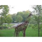
North Harmony: 13 foot tall giraffe at Cheney's Point
North Harmony: Steel Giraffe at Cheney's Point Ny
- add
your
Submit your own pictures of this town and show them to the world
- OSM Map
- Google Map
- MSN Map
Population change since 2000: -10.1%
 |
| Males: 1,156 | |
| Females: 1,111 |
| Median resident age: | 46.3 years |
| New York median age: | 40.7 years |
Zip codes: 14710.
| North Harmony: | $69,915 |
| NY: | $79,557 |
Estimated per capita income in 2022: $35,866 (it was $18,795 in 2000)
North Harmony town income, earnings, and wages data
Estimated median house or condo value in 2022: $135,981 (it was $69,600 in 2000)
| North Harmony: | $135,981 |
| NY: | $400,400 |
Mean prices in 2022: all housing units: $168,876; detached houses: $173,869; townhouses or other attached units: $92,544; in 2-unit structures: $200,826; in 3-to-4-unit structures: $86,545; in 5-or-more-unit structures: $466,469; mobile homes: $70,313
Detailed information about poverty and poor residents in North Harmony, NY

Compare current foreclosures near North Harmony, NY:
| Photo | Address | Area | Beds / Baths | Price | Details |
|---|---|---|---|---|---|

|
#1
Prendergast Ave
Jamestown, NY 14701
|
3,064 sq. feet
|
3 baths 5 beds |
$40,000
|
show details |

|
#2
Euclid Ave
Jamestown, NY 14701
|
2,290 sq. feet
|
2 baths 5 beds |
show details | |

|
#3
N Work St
Falconer, NY 14733
|
1,960 sq. feet
|
1 baths 3 beds |
show details | |

|
#4
W Main St
Falconer, NY 14733
|
1,344 sq. feet
|
1 baths 3 beds |
show details | |

|
#5
Prospect St
Jamestown, NY 14701
|
2,203 sq. feet
|
2 baths 3 beds |
show details | |

|
#6
S Main Street Ext
Jamestown, NY 14701
|
4,733 sq. feet
|
6 baths 5 beds |
show details | |

|
#7
Pardee Ave
Jamestown, NY 14701
|
1,352 sq. feet
|
1 baths 3 beds |
show details | |

|
#8
Harris Ave
Jamestown, NY 14701
|
1,500 sq. feet
|
1 baths 3 beds |
show details | |

|
#9
13th St
Jamestown, NY 14701
|
1,412 sq. feet
|
1 baths 3 beds |
show details | |

|
#10
W 10th St
Jamestown, NY 14701
|
1,796 sq. feet
|
1 baths 4 beds |
show details |
| Photo | Address | Area | Beds / Baths | Price | Details |
|---|---|---|---|---|---|

|
#11
Plank Rd
Mayville, NY 14757
|
1,122 sq. feet
|
1 baths 1 beds |
show details | |

|
#12
Niagara Ave
Jamestown, NY 14701
|
1,733 sq. feet
|
3 baths 3 beds |
show details | |

|
#13
Eagle St
Jamestown, NY 14701
|
1,056 sq. feet
|
1 baths 3 beds |
show details | |

|
#14
English St
Jamestown, NY 14701
|
3,280 sq. feet
|
2 baths 4 beds |
show details | |

|
#15
Prendergast Ave
Jamestown, NY 14701
|
- sq. feet
|
- baths - beds |
$19,900
|
show details |

|
#16
Hebner St
Jamestown, NY 14701
|
1,524 sq. feet
|
2 baths 3 beds |
show details | |

|
#17
Church St
Gerry, NY 14740
|
1,460 sq. feet
|
1 baths 3 beds |
show details | |

|
#18
Crown St
Jamestown, NY 14701
|
1,496 sq. feet
|
2 baths 3 beds |
show details | |

|
#19
E Chautauqua St
Mayville, NY 14757
|
2,012 sq. feet
|
2 baths 4 beds |
show details | |

|
#20
Stowe St
Jamestown, NY 14701
|
1,427 sq. feet
|
2 baths 3 beds |
show details |
| Photo | Address | Area | Beds / Baths | Price | Details |
|---|---|---|---|---|---|

|
#21
W Oak Hill Rd
Jamestown, NY 14701
|
1,260 sq. feet
|
2 baths 2 beds |
show details | |

|
#22
Route 394
Ashville, NY 14710
|
943 sq. feet
|
1 baths 3 beds |
show details | |

|
#23
College St
Ashville, NY 14710
|
2,248 sq. feet
|
2 baths 3 beds |
show details | |

|
#24
Cassadaga Rd
Cassadaga, NY 14718
|
1,122 sq. feet
|
1 baths 2 beds |
show details | |

|
#25
1st St
Portland, NY 14769
|
1,540 sq. feet
|
1 baths 3 beds |
show details | |

|
#26
W Main St
Ripley, NY 14775
|
1,785 sq. feet
|
2 baths 3 beds |
show details | |

|
#27
Maple Grove Rd
Bemus Point, NY 14712
|
1,404 sq. feet
|
2 baths 4 beds |
show details | |

|
#28
York St
Jamestown, NY 14701
|
1,948 sq. feet
|
2 baths 4 beds |
show details | |

|
#29
Bourne St
Westfield, NY 14787
|
1,433 sq. feet
|
2 baths 3 beds |
show details | |

|
#30
Terrace Dr
Gerry, NY 14740
|
1,740 sq. feet
|
1 baths 3 beds |
show details |
| Photo | Address | Area | Beds / Baths | Price | Details |
|---|---|---|---|---|---|

|
#31
Howard St
Jamestown, NY 14701
|
1,404 sq. feet
|
1 baths 2 beds |
show details | |

|
#32
N Pearl St
Frewsburg, NY 14738
|
1,384 sq. feet
|
2 baths 3 beds |
show details | |

|
#33
S Main St
Jamestown, NY 14701
|
1,941 sq. feet
|
2 baths 3 beds |
show details | |

|
#34
Beck Rd
Jamestown, NY 14701
|
2,636 sq. feet
|
2 baths 3 beds |
show details | |

|
#35
Hillview Dr
Lakewood, NY 14750
|
2,205 sq. feet
|
3 baths 4 beds |
show details | |

|
#36
Grove St
Westfield, NY 14787
|
1,921 sq. feet
|
1 baths 4 beds |
show details | |

|
#37
Prosser Hill Rd
Jamestown, NY 14701
|
1,584 sq. feet
|
2 baths 4 beds |
show details | |

|
#38
E Elmwood Ave
Falconer, NY 14733
|
1,420 sq. feet
|
2 baths 3 beds |
show details | |

|
#39
Louisa Ave
Jamestown, NY 14701
|
1,340 sq. feet
|
1 baths 3 beds |
show details | |

|
#40
Elm St
Jamestown, NY 14701
|
1,881 sq. feet
|
2 baths 4 beds |
show details |
| Photo | Address | Area | Beds / Baths | Price | Details |
|---|---|---|---|---|---|

|
#41
Bunce Rd
Frewsburg, NY 14738
|
1,500 sq. feet
|
1 baths 2 beds |
show details | |

|
#42
Harris Ave
Jamestown, NY 14701
|
1,500 sq. feet
|
1 baths 3 beds |
show details | |

|
#43
E Virginia Blvd
Jamestown, NY 14701
|
750 sq. feet
|
1 baths 3 beds |
show details | |

|
#44
Mohawk St
Clymer, NY 14724
|
1,594 sq. feet
|
2 baths 4 beds |
show details | |

|
#45
Woleben Rd
Portland, NY 14769
|
1,904 sq. feet
|
1 baths 4 beds |
show details | |

|
#46
Cass St
Westfield, NY 14787
|
2,706 sq. feet
|
3 baths 4 beds |
show details | |

|
#47
Water St
Frewsburg, NY 14738
|
1,248 sq. feet
|
2 baths 2 beds |
show details | |

|
#48
Fredonia Stockton Rd
Fredonia, NY 14063
|
2 sq. feet
|
3 baths 4 beds |
show details | |

|
#49
Summit Blvd
Jamestown, NY 14701
|
858 sq. feet
|
1 baths 2 beds |
show details | |

|
Check over 1 million property listings on Foreclosure.com!
|
browse all offers | |||

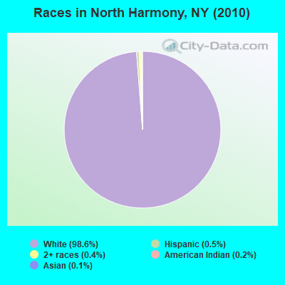
- 2,23598.6%White alone
- 120.5%Hispanic
- 90.4%Two or more races
- 50.2%American Indian alone
- 30.1%Asian alone
- 20.09%Black alone
- 10.04%Other race alone
Races in North Harmony detailed stats: ancestries, foreign born residents, place of birth
 Recent articles from our blog. Our writers, many of them Ph.D. graduates or candidates, create easy-to-read articles on a wide variety of topics.
Ancestries: English (23.1%), German (21.7%), Swedish (17.1%), Irish (13.1%), Dutch (7.9%), Italian (6.4%).
Current Local Time: EST time zone
Land area: 42.2 square miles.
Population density: 54 people per square mile (very low).
43 residents are foreign born
| This town: | 1.7% |
| New York: | 20.4% |
| North Harmony town: | 2.2% ($1,498) |
| New York: | 1.9% ($2,847) |
Nearest city with pop. 50,000+: Erie, PA  (32.8 miles , pop. 103,717).
Nearest city with pop. 200,000+: Buffalo, NY (61.1 miles , pop. 292,648).
Nearest city with pop. 1,000,000+: Philadelphia, PA (268.2 miles , pop. 1,517,550).
Nearest cities:
), ), Latitude: 42.13 N, Longitude: 79.44 W
Area code commonly used in this area: 716
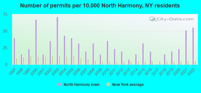
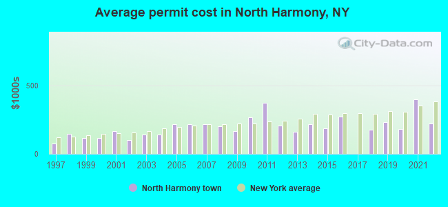
Single-family new house construction building permits:
- 2022: 14 buildings, average cost: $221,100
- 2021: 13 buildings, average cost: $399,800
- 2020: 6 buildings, average cost: $183,300
- 2019: 5 buildings, average cost: $232,000
- 2018: 4 buildings, average cost: $180,300
- 2016: 5 buildings, average cost: $272,200
- 2015: 8 buildings, average cost: $187,500
- 2014: 4 buildings, average cost: $216,300
- 2013: 2 buildings, average cost: $162,500
- 2012: 5 buildings, average cost: $206,000
- 2011: 6 buildings, average cost: $375,800
- 2010: 9 buildings, average cost: $268,300
- 2009: 4 buildings, average cost: $167,500
- 2008: 8 buildings, average cost: $201,100
- 2007: 5 buildings, average cost: $216,700
- 2006: 8 buildings, average cost: $216,700
- 2005: 10 buildings, average cost: $216,700
- 2004: 11 buildings, average cost: $140,100
- 2003: 18 buildings, average cost: $140,100
- 2002: 9 buildings, average cost: $103,400
- 2001: 4 buildings, average cost: $168,800
- 2000: 17 buildings, average cost: $115,000
- 1999: 6 buildings, average cost: $114,500
- 1998: 4 buildings, average cost: $146,800
- 1997: 10 buildings, average cost: $76,600
| Here: | 4.8% |
| New York: | 4.4% |
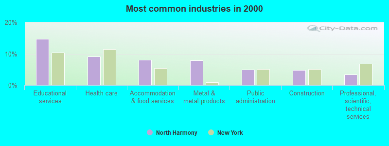
- Educational services (14.7%)
- Health care (9.1%)
- Accommodation & food services (8.1%)
- Metal & metal products (7.9%)
- Public administration (5.0%)
- Construction (4.8%)
- Professional, scientific, technical services (3.5%)
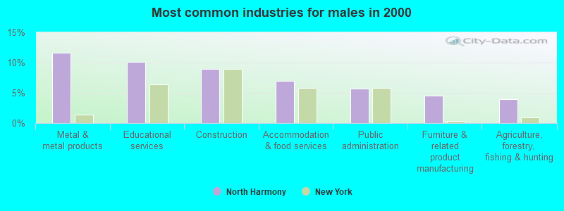
- Metal & metal products (11.6%)
- Educational services (10.2%)
- Construction (9.0%)
- Accommodation & food services (6.9%)
- Public administration (5.7%)
- Furniture & related product manufacturing (4.6%)
- Agriculture, forestry, fishing & hunting (4.0%)
- Educational services (19.9%)
- Health care (16.7%)
- Accommodation & food services (9.4%)
- Social assistance (4.4%)
- Public administration (4.0%)
- Professional, scientific, technical services (4.0%)
- Metal & metal products (3.5%)
- Metal workers and plastic workers (6.5%)
- Preschool, kindergarten, elementary, and middle school teachers (6.3%)
- Building and grounds cleaning and maintenance occupations (4.0%)
- Other management occupations, except farmers and farm managers (3.9%)
- Secretaries and administrative assistants (3.7%)
- Other production occupations, including supervisors (3.4%)
- Other sales and related occupations, including supervisors (3.3%)
- Metal workers and plastic workers (10.9%)
- Other management occupations, except farmers and farm managers (4.9%)
- Driver/sales workers and truck drivers (4.4%)
- Vehicle and mobile equipment mechanics, installers, and repairers (4.4%)
- Other production occupations, including supervisors (4.1%)
- Building and grounds cleaning and maintenance occupations (4.0%)
- Preschool, kindergarten, elementary, and middle school teachers (3.7%)
- Preschool, kindergarten, elementary, and middle school teachers (9.3%)
- Secretaries and administrative assistants (7.9%)
- Information and record clerks, except customer service representatives (5.6%)
- Cashiers (5.1%)
- Health technologists and technicians (4.6%)
- Other teachers, instructors, education, training, and library occupations (4.4%)
- Building and grounds cleaning and maintenance occupations (4.0%)
Average climate in North Harmony, New York
Based on data reported by over 4,000 weather stations


(lower is better)
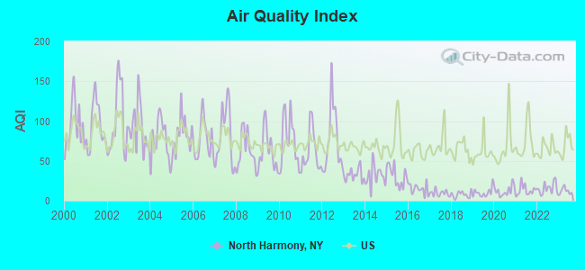
Air Quality Index (AQI) level in 2023 was 12.3. This is significantly better than average.
| City: | 12.3 |
| U.S.: | 72.6 |
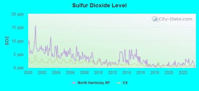
Sulfur Dioxide (SO2) [ppb] level in 2023 was 1.53. This is about average. Closest monitor was 10.4 miles away from the city center.
| City: | 1.53 |
| U.S.: | 1.51 |
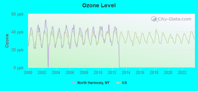
Ozone [ppb] level in 2012 was 36.2. This is about average. Closest monitor was 13.3 miles away from the city center.
| City: | 36.2 |
| U.S.: | 33.3 |
Tornado activity:
North Harmony-area historical tornado activity is above New York state average. It is 40% smaller than the overall U.S. average.
On 5/31/1985, a category F4 (max. wind speeds 207-260 mph) tornado 5.8 miles away from the North Harmony town center .
On 5/2/1983, a category F3 (max. wind speeds 158-206 mph) tornado 9.4 miles away from the town center killed 2 people and caused between $500,000 and $5,000,000 in damages.
Earthquake activity:
North Harmony-area historical earthquake activity is significantly above New York state average. It is 64% smaller than the overall U.S. average.On 9/25/1998 at 19:52:52, a magnitude 5.2 (4.8 MB, 4.3 MS, 5.2 LG, 4.5 MW, Depth: 3.1 mi, Class: Moderate, Intensity: VI - VII) earthquake occurred 66.5 miles away from North Harmony center
On 1/31/1986 at 16:46:43, a magnitude 5.0 (5.0 MB) earthquake occurred 96.0 miles away from North Harmony center
On 8/23/2011 at 17:51:04, a magnitude 5.8 (5.8 MW, Depth: 3.7 mi) earthquake occurred 302.8 miles away from the city center
On 10/7/1983 at 10:18:46, a magnitude 5.3 (5.1 MB, 5.3 LG, 5.1 ML) earthquake occurred 286.6 miles away from the city center
On 4/20/2002 at 10:50:47, a magnitude 5.3 (5.3 ML, Depth: 3.0 mi) earthquake occurred 332.3 miles away from the city center
On 1/26/2001 at 03:03:20, a magnitude 3.9 (3.9 MB, Depth: 3.1 mi, Class: Light, Intensity: II - III) earthquake occurred 71.3 miles away from North Harmony center
Magnitude types: regional Lg-wave magnitude (LG), body-wave magnitude (MB), local magnitude (ML), surface-wave magnitude (MS), moment magnitude (MW)
Natural disasters:
The number of natural disasters in Chautauqua County (21) is greater than the US average (15).Major Disasters (Presidential) Declared: 11
Emergencies Declared: 9
Causes of natural disasters: Floods: 9, Storms: 9, Snowstorms: 4, Hurricanes: 2, Winter Storms: 2, Blizzard: 1, Ice Storm: 1, Power Outage: 1, Snow: 1, Tropical Storm: 1, Wind: 1, Other: 2 (Note: some incidents may be assigned to more than one category).
Hospitals and medical centers near North Harmony:
- HOSPICE CHAUTAUQUA COUNTY INC (Hospital, about 6 miles away; MAYVILLE, NY)
- MANOR OAK SKILLED NURSING FACILITIES JAMESTOWN (Nursing Home, about 11 miles away; JAMESTOWN, NY)
- JAMESTOWN GENERAL HOSPITAL (Hospital, about 11 miles away; JAMESTOWN, NY)
- HERITAGE PARK HEALTH CARE CENTER (Nursing Home, about 11 miles away; JAMESTOWN, NY)
- WOMENS CHRISTIAN ASSOC. HOSP. (Dialysis Facility, about 11 miles away; JAMESTOWN, NY)
- WOMAN'S CHRISTIAN ASSOCIATION Acute Care Hospitals (about 11 miles away; JAMESTOWN, NY)
- CHAUTAUQUA COUNTY CHAPTER NYS ARC, INC (Hospital, about 12 miles away; JAMESTOWN, NY)
Colleges/universities with over 2000 students nearest to North Harmony:
- Jamestown Community College (about 12 miles; Jamestown, NY; Full-time enrollment: 3,384)
- SUNY at Fredonia (about 23 miles; Fredonia, NY; FT enrollment: 5,523)
- Pennsylvania State University-Penn State Erie-Behrend College (about 29 miles; Erie, PA; FT enrollment: 4,025)
- Mercyhurst University (about 32 miles; Erie, PA; FT enrollment: 2,888)
- Gannon University (about 34 miles; Erie, PA; FT enrollment: 3,760)
- Edinboro University of Pennsylvania (about 40 miles; Edinboro, PA; FT enrollment: 6,746)
- St Bonaventure University (about 50 miles; Saint Bonaventure, NY; FT enrollment: 2,286)
Points of interest:
Notable locations in North Harmony: Woodcrest Golf Course (A), Ashville Fire Department (B), Ashville Free Library (C), North Harmony Town Hall (D), Ashville Fire District Station (E). Display/hide their locations on the map
Churches in North Harmony include: Blockville United Methodist Church (A), Ashville Methodist Church (B), Wesleyan Methodist Church (C), North Harmony Church (D), Open Meadows Church (E). Display/hide their locations on the map
Cemeteries: Gardner Cemetery (1), Open Meadows Cemetery (2), Wild Rose Cemetery (3), North Harmony (4), Maple Grove Cemetery (5). Display/hide their locations on the map
Creek: Goose Creek (A). Display/hide its location on the map
| This town: | 2.5 people |
| New York: | 2.6 people |
| This town: | 75.0% |
| Whole state: | 63.5% |
| This town: | 7.3% |
| Whole state: | 6.8% |
Likely homosexual households (counted as self-reported same-sex unmarried-partner households)
- Lesbian couples: 0.2% of all households
- Gay men: 0.9% of all households
| This town: | 9.7% |
| Whole state: | 14.6% |
| This town: | 3.4% |
| Whole state: | 7.4% |
For population 15 years and over in North Harmony:
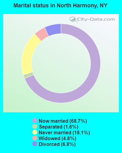
- Never married: 18.1%
- Now married: 68.7%
- Separated: 1.6%
- Widowed: 4.8%
- Divorced: 6.8%
For population 25 years and over in North Harmony:
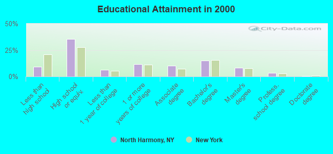
- High school or higher: 90.7%
- Bachelor's degree or higher: 27.2%
- Graduate or professional degree: 12.2%
- Unemployed: 3.3%
- Mean travel time to work (commute): 21.3 minutes
| Here: | 10.1 |
| New York average: | 14.2 |
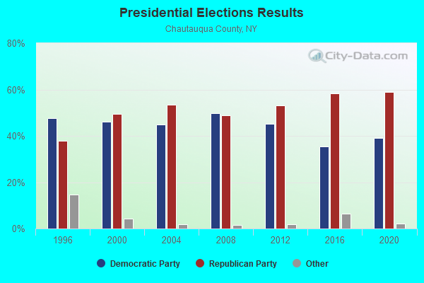
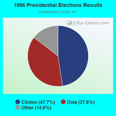
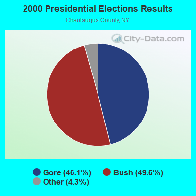
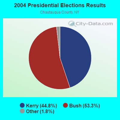
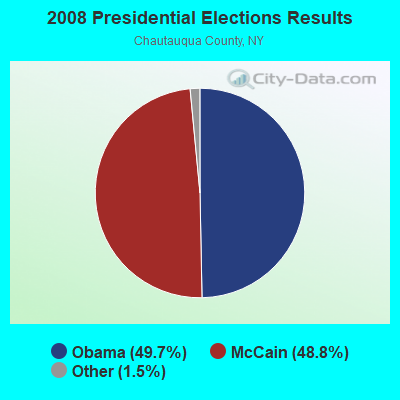
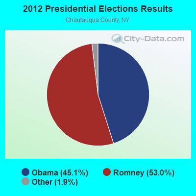
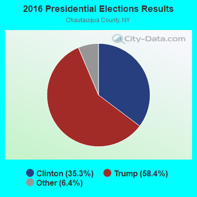
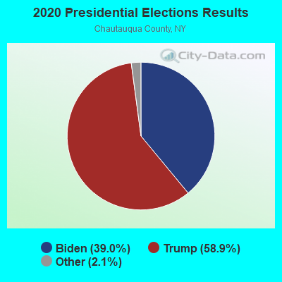
Graphs represent county-level data. Detailed 2008 Election Results
Religion statistics for North Harmony, NY (based on Chautauqua County data)
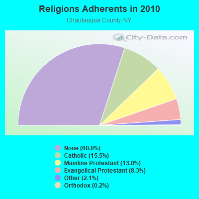
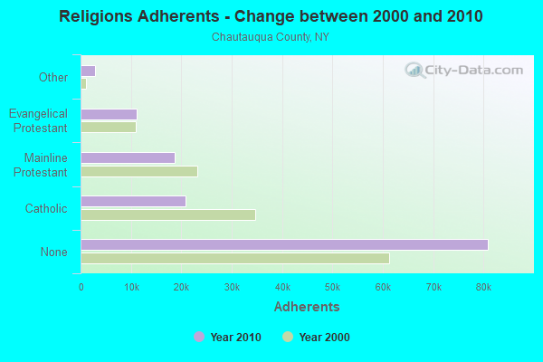
| Religion | Adherents | Congregations |
|---|---|---|
| Catholic | 20,912 | 13 |
| Mainline Protestant | 18,659 | 86 |
| Evangelical Protestant | 11,175 | 105 |
| Other | 2,884 | 19 |
| Orthodox | 230 | 2 |
| Black Protestant | 120 | 1 |
| None | 80,925 | - |
Food Environment Statistics:
| This county: | 2.76 / 10,000 pop. |
| New York: | 4.13 / 10,000 pop. |
| This county: | 0.07 / 10,000 pop. |
| New York: | 0.06 / 10,000 pop. |
| Chautauqua County: | 1.12 / 10,000 pop. |
| New York: | 0.92 / 10,000 pop. |
| Chautauqua County: | 3.06 / 10,000 pop. |
| New York: | 1.68 / 10,000 pop. |
| Here: | 11.05 / 10,000 pop. |
| New York: | 8.82 / 10,000 pop. |
| Here: | 8.1% |
| New York: | 8.2% |
| Chautauqua County: | 29.3% |
| New York: | 23.8% |
| Chautauqua County: | 12.4% |
| New York: | 15.6% |
Strongest AM radio stations in North Harmony:
- WWKB (1520 AM; 50 kW; BUFFALO, NY; Owner: ENTERCOM BUFFALO LICENSE, LLC)
- WJTN (1240 AM; 1 kW; JAMESTOWN, NY; Owner: MEDIA ONE GROUP, LLC)
- WKSN (1340 AM; 1 kW; JAMESTOWN, NY; Owner: VOX ALLEGANY, L.L.C.)
- WNAE (1310 AM; 5 kW; WARREN, PA; Owner: KINZUA BROADCASTING COMPANY)
- WRIE (1260 AM; 5 kW; ERIE, PA; Owner: REGENT LICENSEE OF ERIE, INC.)
- KDKA (1020 AM; 50 kW; PITTSBURGH, PA; Owner: INFINITY BROADCASTING OPERATIONS, INC.)
- WFNN (1330 AM; 5 kW; ERIE, PA; Owner: NM LICENSING, LLC)
- WHAM (1180 AM; 50 kW; ROCHESTER, NY; Owner: CITICASTERS LICENSES, L.P.)
- WKNR (850 AM; 50 kW; CLEVELAND, OH; Owner: CARON BROADCASTING, INC.)
- WGR (550 AM; 5 kW; BUFFALO, NY; Owner: ENTERCOM BUFFALO LICENSE, LLC)
- WTAM (1100 AM; 50 kW; CLEVELAND, OH; Owner: JACOR BROADCASTING CORPORATION)
- WHK (1220 AM; 50 kW; CLEVELAND, OH; Owner: CARON BROADCASTING, INC.)
- WWCB (1370 AM; 1 kW; CORRY, PA; Owner: CORRY COMMUNICATIONS CORPORATION)
Strongest FM radio stations in North Harmony:
- WUBJ (88.1 FM; JAMESTOWN, NY; Owner: STATE UNIVERSITY OF NEW YORK)
- W205BA (88.9 FM; JAMESTOWN, NY; Owner: BIBLE BROADCASTING NETWORK, INC.)
- WWSE (93.3 FM; JAMESTOWN, NY; Owner: MEDIA ONE GROUP, LLC)
- WKZA (106.9 FM; LAKEWOOD, NY; Owner: CROSS COUNTRY COMMUNICATIONS, LLC)
- WBKX (96.5 FM; FREDONIA, NY; Owner: CHADWICK BAY BROADCASTING CORPORATION)
- WNJA (89.7 FM; JAMESTOWN, NY; Owner: WESTERN NEW YORK PUBLIC B/CING ASSOC)
- WMHU (101.9 FM; JAMESTOWN, NY; Owner: VOX ALLEGANY, L.L.C.)
- WRKT (100.9 FM; NORTH EAST, PA; Owner: NM LICENSING, LLC)
- WCOT (90.9 FM; JAMESTOWN, NY; Owner: FAMILY LIFE MINISTRIES, INC.)
- WQFX-FM (103.1 FM; RUSSELL, PA; Owner: SOUTHBRIDGE RADIO CORPORATION)
- WRTS (103.7 FM; ERIE, PA; Owner: NM LICENSING, LLC)
- WMCE (88.5 FM; ERIE, PA; Owner: MERCYHURST COLLEGE)
- WXKC (99.9 FM; ERIE, PA; Owner: REGENT LICENSEE OF ERIE, INC.)
- WFGO (94.7 FM; ERIE, PA; Owner: NM LICENSING, LLC)
- WQHZ (102.3 FM; ERIE, PA; Owner: REGENT LICENSEE OF ERIE, INC.)
- WRRN (92.3 FM; WARREN, PA; Owner: KINZUA BROADCASTING COMPANY, INC.)
- WCTL (106.3 FM; UNION CITY, PA; Owner: INSPIRATION TIME, INC.)
- WKNB (104.3 FM; CLARENDON, PA; Owner: KINZUA BROADCASTING CO., INC)
TV broadcast stations around North Harmony:
- W46BA (Channel 46; JAMESTOWN, NY; Owner: WESTERN NEW YORK PUBLIC B/CING.ASSN.)
- WNYB (Channel 26; JAMESTOWN, NY; Owner: FAITH BROADCASTING NETWORK, INC.)
- WICU-TV (Channel 12; ERIE, PA; Owner: SJL OF PENNSYLVANIA, INC.)
- WJET-TV (Channel 24; ERIE, PA; Owner: NEXSTAR BROADCASTING OF ERIE, L.L.C.)
- WSEE-TV (Channel 35; ERIE, PA; Owner: INITIAL BROADCASTING OF PENNSYLVANIA LICENSE SUBSIDIARY, LLC)
- WQLN (Channel 54; ERIE, PA; Owner: PUBLIC B/C OF NW PENN. INC.)
- WFXP (Channel 66; ERIE, PA; Owner: MISSION BROADCASTING, INC.)
- WNGS (Channel 67; SPRINGVILLE, NY; Owner: CAROLINE K. POWLEY D/B/A UNICORN/SPRINGVILLE)
- W10BH (Channel 10; JAMESTOWN, NY; Owner: TRINITY BROADCASTING NETWORK)
- National Bridge Inventory (NBI) Statistics
- 34Number of bridges
- 203ft / 62.5mTotal length
- $54,485,000Total costs
- 55,617Total average daily traffic
- 9,872Total average daily truck traffic
- New bridges - historical statistics
- 21960-1969
- 11970-1979
- 161980-1989
- 91990-1999
- 22000-2009
- 32010-2019
- 12020-2022
FCC Registered Antenna Towers:
13 (See the full list of FCC Registered Antenna Towers in North Harmony)FCC Registered Broadcast Land Mobile Towers:
1- Stow Service Ctr Rt 17j 1 Mi W Rt 631 (Lat: 42.160889 Lon: -79.423389), Call Sign: KNFB422, Licensee ID: L00006600,
Assigned Frequencies: 158.265 MHz, Grant Date: 01/01/2002, Expiration Date: 03/10/2012, Cancellation Date: 03/25/2004, Certifier: Chris Kelly, Registrant: National Grid Usa Service Company, Inc., 300 Erie Boulevard West, Syracuse, NY 13202, Phone: (315) 428-5997, Fax: (315) 428-3132, Email:
- 42.1%Utility gas
- 21.9%Bottled, tank, or LP gas
- 13.9%Fuel oil, kerosene, etc.
- 11.2%Wood
- 7.2%Electricity
- 3.7%Other fuel
- 68.5%Utility gas
- 22.6%Fuel oil, kerosene, etc.
- 5.6%Bottled, tank, or LP gas
- 3.2%Wood
North Harmony compared to New York state average:
- Median house value significantly below state average.
- Unemployed percentage significantly below state average.
- Black race population percentage significantly below state average.
- Hispanic race population percentage significantly below state average.
- Median age above state average.
- Foreign-born population percentage significantly below state average.
- Renting percentage significantly below state average.
- Length of stay since moving in significantly above state average.
- Number of rooms per house significantly below state average.
- House age significantly below state average.