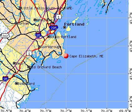
Cape Elizabeth, Maine
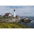
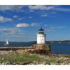
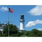
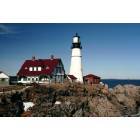
Cape Elizabeth: Portland Head Light, Cape Elizabeth, Maine
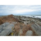
Cape Elizabeth: Rams Ledge Light - From Ft. Williams
Cape Elizabeth: Portland Head Light
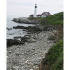
Cape Elizabeth: Portland Head Lighthouse coastal view
Cape Elizabeth: Beautiful little Bug Light! Old fort in background.
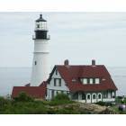
Cape Elizabeth: Portland Head Lighthouse
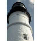
Cape Elizabeth: The Portland Head Light.
Cape Elizabeth: Random photo on our family trip to view the lighthouses,God Bless America!
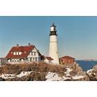
Cape Elizabeth: The Portland Head Light during winter
Cape Elizabeth: Cold December day2
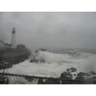
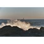
Cape Elizabeth: Portland Headlight during a storm
- see
21
more - add
your
Submit your own pictures of this town and show them to the world
- OSM Map
- General Map
- Google Map
- MSN Map
Population change since 2000: -0.6%
 |
| Males: 4,343 | |
| Females: 4,672 |
| Median resident age: | 46.8 years |
| Maine median age: | 43.0 years |
Zip codes: 04107.
| Cape Elizabeth: | $146,770 |
| ME: | $69,543 |
Estimated per capita income in 2022: $87,339 (it was $37,983 in 2000)
Cape Elizabeth town income, earnings, and wages data
Estimated median house or condo value in 2022: $638,234 (it was $187,300 in 2000)
| Cape Elizabeth: | $638,234 |
| ME: | $290,600 |
Mean prices in 2022: all housing units: $514,200; detached houses: $533,395; townhouses or other attached units: $572,947; in 2-unit structures: $538,406; in 3-to-4-unit structures: $462,507; in 5-or-more-unit structures: $450,834; mobile homes: $93,551
Cape Elizabeth, ME residents, houses, and apartments details
Detailed information about poverty and poor residents in Cape Elizabeth, ME


- 8,61695.6%White alone
- 1301.4%Hispanic
- 1211.3%Asian alone
- 861.0%Two or more races
- 380.4%Black alone
- 110.1%American Indian alone
- 80.09%Other race alone
- 50.06%Native Hawaiian and Other
Pacific Islander alone
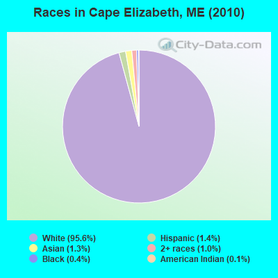
Races in Cape Elizabeth detailed stats: ancestries, foreign born residents, place of birth
Type |
2009 |
2010 |
2011 |
2012 |
2013 |
2014 |
2015 |
2016 |
2017 |
2018 |
2019 |
2020 |
2021 |
2022 |
|---|---|---|---|---|---|---|---|---|---|---|---|---|---|---|
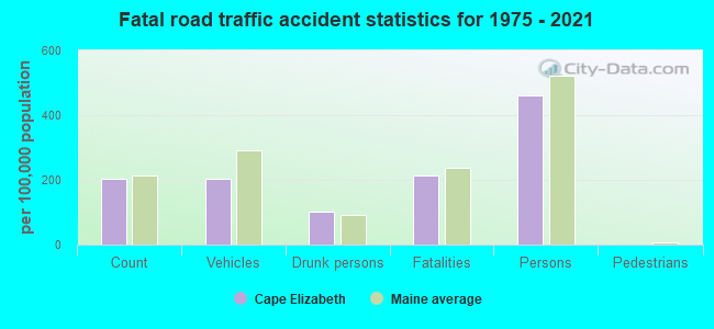
| Murders (per 100,000) | 0 (0.0) | 0 (0.0) | 0 (0.0) | 0 (0.0) | 0 (0.0) | 0 (0.0) | 0 (0.0) | 0 (0.0) | 0 (0.0) | 0 (0.0) | 0 (0.0) | 0 (0.0) | 0 (0.0) | 0 (0.0) |
| Rapes (per 100,000) | 0 (0.0) | 0 (0.0) | 0 (0.0) | 1 (11.1) | 0 (0.0) | 4 (43.7) | 0 (0.0) | 0 (0.0) | 0 (0.0) | 1 (10.7) | 1 (10.7) | 1 (10.7) | 1 (10.7) | 0 (0.0) |
| Robberies (per 100,000) | 0 (0.0) | 0 (0.0) | 1 (11.1) | 1 (11.1) | 0 (0.0) | 0 (0.0) | 0 (0.0) | 0 (0.0) | 0 (0.0) | 0 (0.0) | 0 (0.0) | 0 (0.0) | 0 (0.0) | 0 (0.0) |
| Assaults (per 100,000) | 1 (11.4) | 1 (11.1) | 0 (0.0) | 0 (0.0) | 0 (0.0) | 2 (21.9) | 0 (0.0) | 0 (0.0) | 1 (10.7) | 0 (0.0) | 0 (0.0) | 2 (21.4) | 3 (32.1) | 1 (10.5) |
| Burglaries (per 100,000) | 10 (114.0) | 14 (155.3) | 16 (177.5) | 33 (364.8) | 26 (285.6) | 18 (196.7) | 23 (249.2) | 26 (277.7) | 9 (95.9) | 8 (85.5) | 11 (117.6) | 1 (10.7) | 0 (0.0) | 5 (52.4) |
| Thefts (per 100,000) | 63 (718.4) | 104 (1,154) | 90 (998.4) | 77 (851.3) | 70 (768.9) | 69 (754.0) | 62 (671.7) | 28 (299.0) | 31 (330.4) | 35 (374.0) | 34 (363.6) | 29 (310.5) | 6 (64.1) | 19 (199.3) |
| Auto thefts (per 100,000) | 2 (22.8) | 1 (11.1) | 2 (22.2) | 5 (55.3) | 2 (22.0) | 0 (0.0) | 1 (10.8) | 0 (0.0) | 1 (10.7) | 0 (0.0) | 1 (10.7) | 0 (0.0) | 0 (0.0) | 1 (10.5) |
| Arson (per 100,000) | 0 (0.0) | 1 (11.1) | 0 (0.0) | 1 (11.1) | 2 (22.0) | 0 (0.0) | 0 (0.0) | 0 (0.0) | 0 (0.0) | 0 (0.0) | 1 (10.7) | 0 (0.0) | 0 (0.0) | 0 (0.0) |
| City-Data.com crime index | 40.8 | 60.1 | 57.5 | 76.2 | 52.5 | 83.3 | 45.2 | 31.4 | 22.9 | 29.5 | 32.2 | 26.0 | 17.5 | 14.6 |
The City-Data.com crime index weighs serious crimes and violent crimes more heavily. Higher means more crime, U.S. average is 246.1. It adjusts for the number of visitors and daily workers commuting into cities.
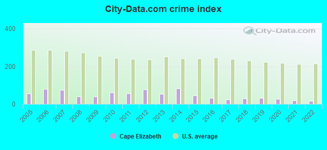
Crime rate in Cape Elizabeth detailed stats: murders, rapes, robberies, assaults, burglaries, thefts, arson
Full-time law enforcement employees in 2021, including police officers: 13 (12 officers - 12 male; 0 female).
| Officers per 1,000 residents here: | 1.28 |
| Maine average: | 1.71 |
 Recent articles from our blog. Our writers, many of them Ph.D. graduates or candidates, create easy-to-read articles on a wide variety of topics.


Latest news from Cape Elizabeth, ME collected exclusively by city-data.com from local newspapers, TV, and radio stations
Cape Elizabeth, ME City Guides:
Ancestries: English (27.0%), Irish (25.5%), Italian (10.3%), German (9.7%), French (7.3%), Scottish (6.5%).
Current Local Time: EST time zone
Incorporated on 11/01/1765
Land area: 14.7 square miles.
Population density: 612 people per square mile (low).
271 residents are foreign born (1.8% Europe, 0.6% Asia, 0.4% North America).
| This town: | 3.0% |
| Maine: | 2.9% |
| Cape Elizabeth town: | 1.6% ($3,047) |
| Maine: | 1.5% ($1,417) |
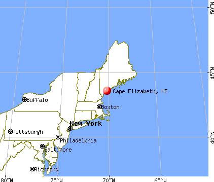
Nearest city with pop. 50,000+: Portland, ME  (4.7 miles , pop. 64,249).
Nearest city with pop. 200,000+: Boston, MA (98.9 miles , pop. 589,141).
Nearest city with pop. 1,000,000+: Bronx, NY (266.9 miles , pop. 1,332,650).
Nearest cities:
), Latitude: 43.60 N, Longitude: 70.23 W
Area code commonly used in this area: 207


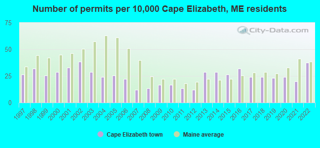
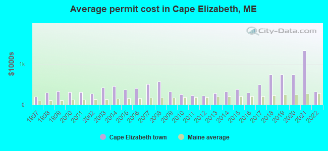
Single-family new house construction building permits:
- 2022: 34 buildings, average cost: $315,100
- 2021: 18 buildings, average cost: $1,327,800
- 2020: 22 buildings, average cost: $739,300
- 2019: 21 buildings, average cost: $739,300
- 2018: 22 buildings, average cost: $739,300
- 2017: 22 buildings, average cost: $488,600
- 2016: 29 buildings, average cost: $289,000
- 2015: 24 buildings, average cost: $375,700
- 2014: 26 buildings, average cost: $320,100
- 2013: 26 buildings, average cost: $285,500
- 2012: 11 buildings, average cost: $221,000
- 2011: 12 buildings, average cost: $237,900
- 2010: 15 buildings, average cost: $254,000
- 2009: 15 buildings, average cost: $324,700
- 2008: 12 buildings, average cost: $559,700
- 2007: 11 buildings, average cost: $501,800
- 2006: 20 buildings, average cost: $408,600
- 2005: 23 buildings, average cost: $374,300
- 2004: 22 buildings, average cost: $457,100
- 2003: 26 buildings, average cost: $413,100
- 2002: 35 buildings, average cost: $266,500
- 2001: 30 buildings, average cost: $309,600
- 2000: 26 buildings, average cost: $307,800
- 1999: 23 buildings, average cost: $328,100
- 1998: 29 buildings, average cost: $301,300
- 1997: 24 buildings, average cost: $197,700
| Here: | 2.4% |
| Maine: | 3.4% |
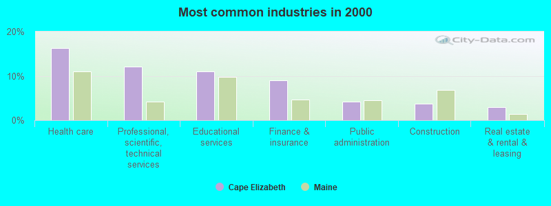
- Health care (16.2%)
- Professional, scientific, technical services (12.1%)
- Educational services (11.0%)
- Finance & insurance (8.9%)
- Public administration (4.2%)
- Construction (3.7%)
- Real estate & rental & leasing (3.0%)
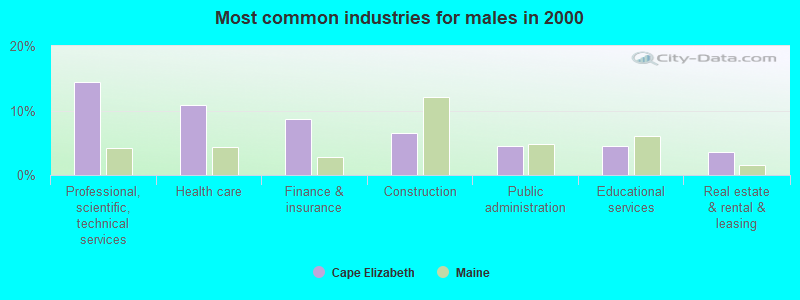
- Professional, scientific, technical services (14.4%)
- Health care (10.8%)
- Finance & insurance (8.7%)
- Construction (6.5%)
- Public administration (4.5%)
- Educational services (4.4%)
- Real estate & rental & leasing (3.6%)
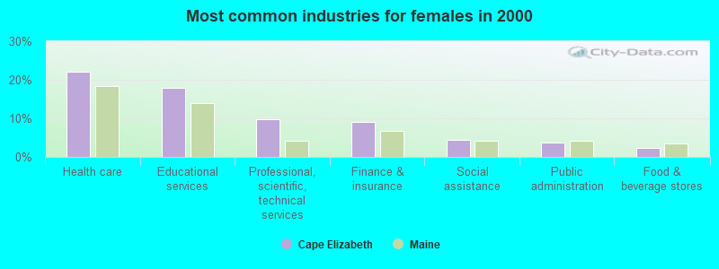
- Health care (22.0%)
- Educational services (18.0%)
- Professional, scientific, technical services (9.7%)
- Finance & insurance (9.2%)
- Social assistance (4.4%)
- Public administration (3.8%)
- Food & beverage stores (2.4%)
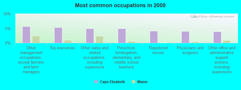
- Other management occupations, except farmers and farm managers (5.7%)
- Top executives (5.4%)
- Other sales and related occupations, including supervisors (4.9%)
- Preschool, kindergarten, elementary, and middle school teachers (4.9%)
- Registered nurses (4.1%)
- Physicians and surgeons (4.0%)
- Other office and administrative support workers, including supervisors (3.9%)
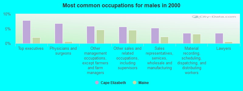
- Top executives (7.8%)
- Physicians and surgeons (6.8%)
- Other management occupations, except farmers and farm managers (5.8%)
- Other sales and related occupations, including supervisors (5.7%)
- Sales representatives, services, wholesale and manufacturing (5.3%)
- Material recording, scheduling, dispatching, and distributing workers (3.5%)
- Lawyers (3.5%)
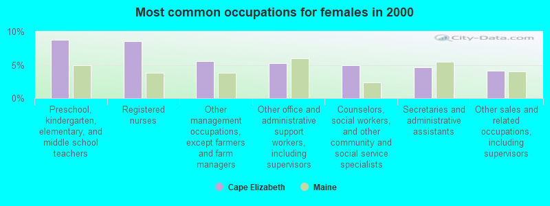
- Preschool, kindergarten, elementary, and middle school teachers (8.8%)
- Registered nurses (8.5%)
- Other management occupations, except farmers and farm managers (5.5%)
- Other office and administrative support workers, including supervisors (5.2%)
- Counselors, social workers, and other community and social service specialists (4.9%)
- Secretaries and administrative assistants (4.7%)
- Other sales and related occupations, including supervisors (4.1%)
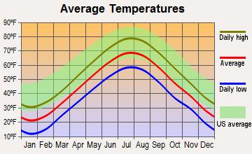
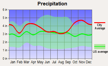
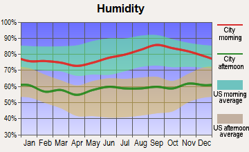
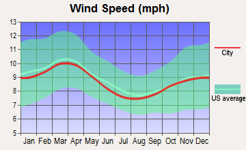
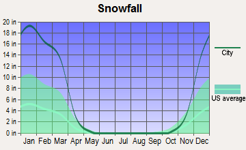
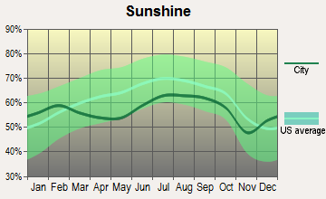
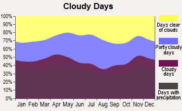
Average climate in Cape Elizabeth, Maine
Based on data reported by over 4,000 weather stations
(lower is better)
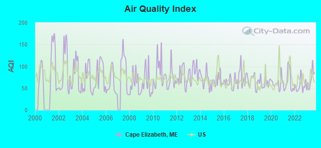
Air Quality Index (AQI) level in 2023 was 69.7. This is about average.
| City: | 69.7 |
| U.S.: | 72.6 |
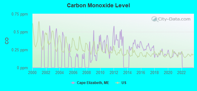
Carbon Monoxide (CO) [ppm] level in 2021 was 0.192. This is better than average. Closest monitor was 3.2 miles away from the city center.
| City: | 0.192 |
| U.S.: | 0.251 |
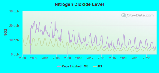
Nitrogen Dioxide (NO2) [ppb] level in 2023 was 5.47. This is about average. Closest monitor was 3.2 miles away from the city center.
| City: | 5.47 |
| U.S.: | 5.11 |
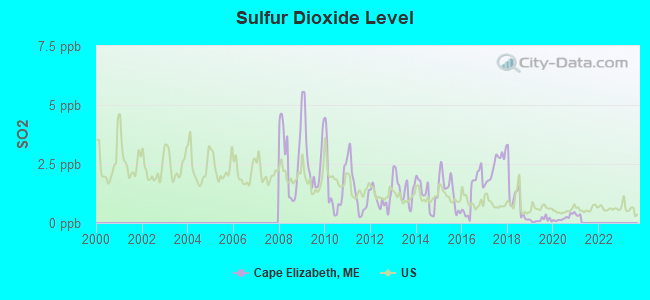
Sulfur Dioxide (SO2) [ppb] level in 2020 was 0.222. This is significantly better than average. Closest monitor was 1.5 miles away from the city center.
| City: | 0.222 |
| U.S.: | 1.515 |
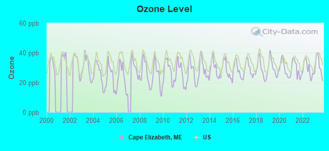
Ozone [ppb] level in 2023 was 31.4. This is about average. Closest monitor was 3.0 miles away from the city center.
| City: | 31.4 |
| U.S.: | 33.3 |
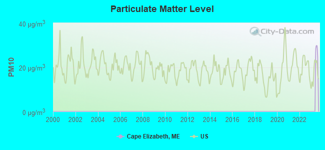
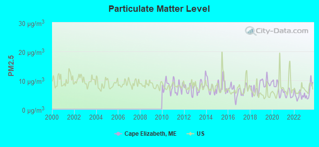
Particulate Matter (PM2.5) [µg/m3] level in 2023 was 6.40. This is better than average. Closest monitor was 3.2 miles away from the city center.
| City: | 6.40 |
| U.S.: | 8.11 |
Tornado activity:
Cape Elizabeth-area historical tornado activity is above Maine state average. It is 78% smaller than the overall U.S. average.
On 10/10/1966, a category F2 (max. wind speeds 113-157 mph) tornado 30.3 miles away from the Cape Elizabeth town center caused between $5000 and $50,000 in damages.
On 6/9/1953, a category F3 (max. wind speeds 158-206 mph) tornado 57.7 miles away from the town center injured 5 people and caused between $5000 and $50,000 in damages.
Earthquake activity:
Cape Elizabeth-area historical earthquake activity is significantly above Maine state average. It is 75% smaller than the overall U.S. average.On 10/16/2012 at 23:12:25, a magnitude 4.7 (4.7 ML, Depth: 10.0 mi, Class: Light, Intensity: IV - V) earthquake occurred 21.5 miles away from Cape Elizabeth center
On 4/20/2002 at 10:50:47, a magnitude 5.3 (5.3 ML, Depth: 3.0 mi, Class: Moderate, Intensity: VI - VII) earthquake occurred 183.6 miles away from Cape Elizabeth center
On 1/19/1982 at 00:14:42, a magnitude 4.7 (4.5 MB, 4.7 MD, 4.5 LG) earthquake occurred 69.2 miles away from Cape Elizabeth center
On 4/20/2002 at 10:50:47, a magnitude 5.2 (5.2 MB, 4.2 MS, 5.2 MW, 5.0 MW) earthquake occurred 184.0 miles away from the city center
On 10/7/1983 at 10:18:46, a magnitude 5.3 (5.1 MB, 5.3 LG, 5.1 ML) earthquake occurred 206.9 miles away from the city center
On 8/21/1996 at 07:54:14, a magnitude 3.8 (3.8 LG, 3.6 LG, Depth: 6.2 mi, Class: Light, Intensity: II - III) earthquake occurred 68.9 miles away from the city center
Magnitude types: regional Lg-wave magnitude (LG), body-wave magnitude (MB), duration magnitude (MD), local magnitude (ML), surface-wave magnitude (MS), moment magnitude (MW)
Natural disasters:
The number of natural disasters in Cumberland County (33) is a lot greater than the US average (15).Major Disasters (Presidential) Declared: 22
Emergencies Declared: 10
Causes of natural disasters: Floods: 19, Storms: 13, Snows: 7, Winter Storms: 6, Heavy Rains: 3, Hurricanes: 3, Winds: 3, Blizzard: 1, Ice Storm: 1, Mudslide: 1, Snowfall: 1, Snowstorm: 1, Tornado: 1, Other: 2 (Note: some incidents may be assigned to more than one category).
Hospitals and medical centers in Cape Elizabeth:
Other hospitals and medical centers near Cape Elizabeth:
- SOUTH PORTLAND NURSING HOME (Nursing Home, about 3 miles away; SO PORTLAND, ME)
- HILLSIDE REST AND NURSING HOME (Nursing Home, about 3 miles away; PORTLAND, ME)
- BEACON HOSPICE (Hospital, about 4 miles away; SO PORTLAND, ME)
- INTERIM HEALTHCARE OF PORTLAND, MAINE (Home Health Center, about 4 miles away; SO PORTLAND, ME)
- MERCY HOSPITAL Acute Care Hospitals (about 4 miles away; PORTLAND, ME)
- MAINE MEDICAL CENTER Acute Care Hospitals (about 5 miles away; PORTLAND, ME)
- AMEDISYS HOME HEALTH (Home Health Center, about 5 miles away; PORTLAND, ME)
Amtrak stations near Cape Elizabeth:
Colleges/universities with over 2000 students nearest to Cape Elizabeth:
- Southern Maine Community College (about 3 miles; South Portland, ME; Full-time enrollment: 4,666)
- University of Southern Maine (about 5 miles; Portland, ME; FT enrollment: 6,647)
- University of New England (about 13 miles; Biddeford, ME; FT enrollment: 4,539)
- Saint Joseph's College of Maine (about 21 miles; Standish, ME; FT enrollment: 2,010)
- University of New Hampshire-Main Campus (about 49 miles; Durham, NH; FT enrollment: 15,243)
- University of Maine at Augusta (about 56 miles; Augusta, ME; FT enrollment: 3,204)
- Northern Essex Community College (about 70 miles; Haverhill, MA; FT enrollment: 4,737)
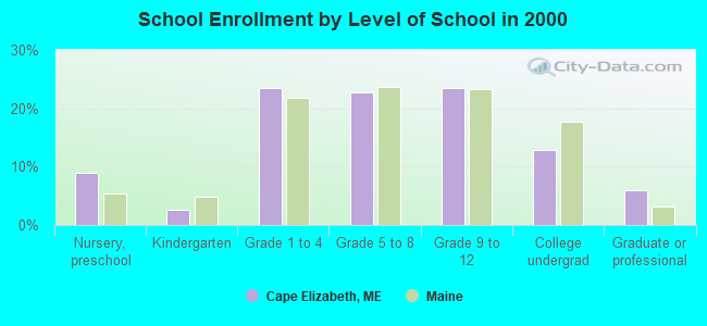
Public high school in Cape Elizabeth:
- CAPE ELIZABETH HIGH SCHOOL (Students: 598, Location: 345 OCEAN HOUSE ROAD, Grades: 9-12)
Private high school in Cape Elizabeth:
Public elementary/middle schools in Cape Elizabeth:
- CAPE ELIZABETH MIDDLE SCHOOL (Students: 573, Location: 14 SCOTT DYER ROAD, Grades: 5-8)
- POND COVE ELEMENTARY (Location: 12 SCOTT DYER ROAD, Grades: KG-4)
Points of interest:
Notable locations in Cape Elizabeth: Cape Elizabeth Light (A), Cape Elizabeth Town Hall (B), Cape Cottage Fire Station (C), Thomas Memorial Library (D), Town Center Station Cape Elizabeth Company 3 (E). Display/hide their locations on the map
Shopping Center: Pond Cove Shopping Center (1). Display/hide its location on the map
Churches in Cape Elizabeth include: Cape Elizabeth Church (A), Cape Elizabeth United Methodist Church (B), The Church of Jesus Christ of Latter Day Saints (C), Saint Albans Episcopal Church (D), Spurwink Church (E). Display/hide their locations on the map
Cemetery: Riverside Cemetery (1). Display/hide its location on the map
Lakes: Great Pond (A), Little Pond (B), Richards Pond (C). Display/hide their locations on the map
Streams, rivers, and creeks: Alewife Brook (A), Willow Brook (B), Pond Cove Brook (C), Dyer Brook (D). Display/hide their locations on the map
Parks in Cape Elizabeth include: Two Lights State Park (1), Crescent Beach State Park (2). Display/hide their locations on the map
Beaches: Crescent Beach (A), Cliff House Beach (B). Display/hide their locations on the map
Tourist attraction: The Lobster Shack (225 Two Lights Road).
Hotel: Inn by the Sea (Hotel Bowery Beach R).
Birthplace of: Joan Benoit - Long-distance runner.
Drinking water stations with addresses in Cape Elizabeth and their reported violations in the past:
ALFORD LAKE CAMP #2 (Population served: 245, Groundwater):Past monitoring violations:ISLAND HOME CLUB (Population served: 240, Surface water):
- 3 regular monitoring violations
Past monitoring violations:
- One routine major monitoring violation
- One regular monitoring violation
| This town: | 2.5 people |
| Maine: | 2.3 people |
| This town: | 72.5% |
| Whole state: | 62.9% |
| This town: | 4.9% |
| Whole state: | 9.4% |
Likely homosexual households (counted as self-reported same-sex unmarried-partner households)
- Lesbian couples: 0.7% of all households
- Gay men: 0.6% of all households
| This town: | 3.1% |
| Whole state: | 10.9% |
| This town: | 1.5% |
| Whole state: | 4.1% |
Banks with branches in Cape Elizabeth (2011 data):
- KeyBank National Association: Cape Elizabeth Branch at 1234 Shore Road, branch established on 1966/04/30. Info updated 2008/03/03: Bank assets: $86,198.8 mil, Deposits: $64,214.8 mil, headquarters in Cleveland, OH, positive income, Commercial Lending Specialization, 1067 total offices, Holding Company: Keycorp
For population 15 years and over in Cape Elizabeth:
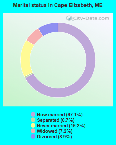
- Never married: 16.2%
- Now married: 67.1%
- Separated: 0.7%
- Widowed: 7.2%
- Divorced: 8.9%
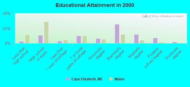
For population 25 years and over in Cape Elizabeth:
- High school or higher: 96.8%
- Bachelor's degree or higher: 58.7%
- Graduate or professional degree: 26.8%
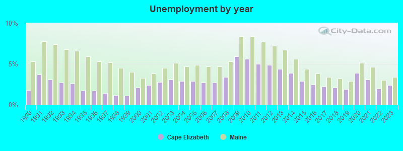
- Unemployed: 3.3%
- Mean travel time to work (commute): 18.8 minutes
| Here: | 9.6 |
| Maine average: | 11.2 |
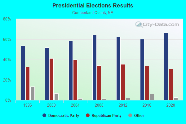
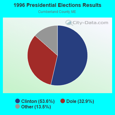
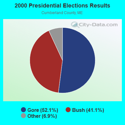
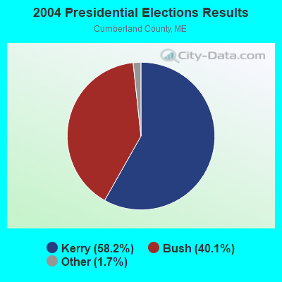
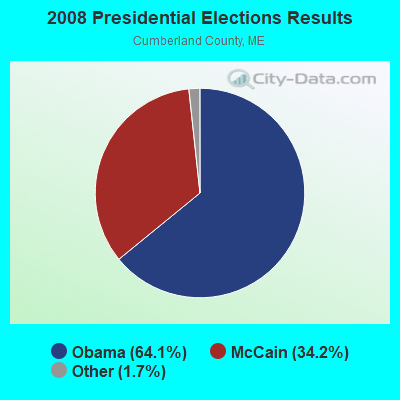
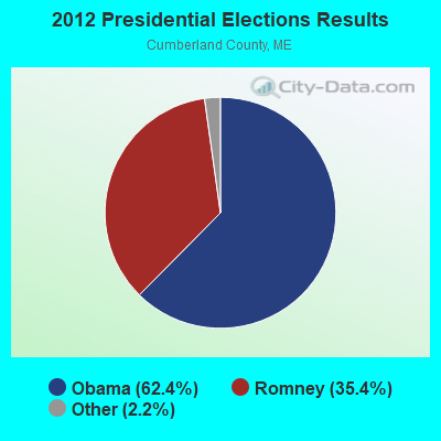
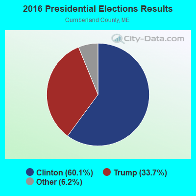
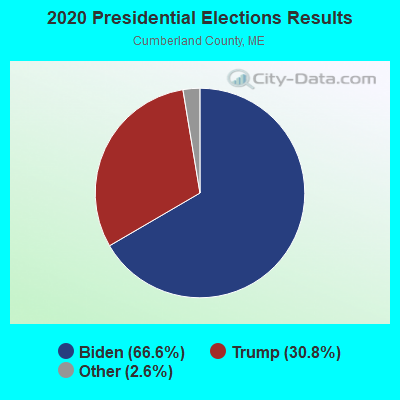
Graphs represent county-level data. Detailed 2008 Election Results
Political contributions by individuals in Cape Elizabeth, ME
Religion statistics for Cape Elizabeth, ME (based on Cumberland County data)
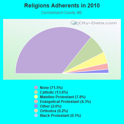
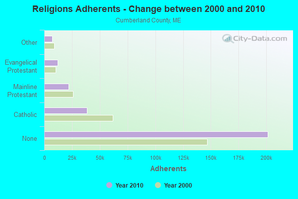
| Religion | Adherents | Congregations |
|---|---|---|
| Catholic | 38,243 | 19 |
| Mainline Protestant | 22,030 | 96 |
| Evangelical Protestant | 12,007 | 85 |
| Other | 7,187 | 44 |
| Orthodox | 500 | 1 |
| Black Protestant | 285 | 2 |
| None | 201,422 | - |
Food Environment Statistics:
| Cumberland County: | 2.62 / 10,000 pop. |
| State: | 2.80 / 10,000 pop. |
| Cumberland County: | 0.11 / 10,000 pop. |
| Maine: | 0.14 / 10,000 pop. |
| Cumberland County: | 2.44 / 10,000 pop. |
| Maine: | 2.20 / 10,000 pop. |
| Cumberland County: | 3.82 / 10,000 pop. |
| Maine: | 5.75 / 10,000 pop. |
| Here: | 12.01 / 10,000 pop. |
| Maine: | 11.02 / 10,000 pop. |
| This county: | 7.1% |
| State: | 8.2% |
| Here: | 19.5% |
| Maine: | 25.0% |
Businesses in Cape Elizabeth, ME
- CVS: 1
- Circle K: 1
Strongest AM radio stations in Cape Elizabeth:
- WZAN (970 AM; 5 kW; PORTLAND, ME; Owner: SAGA COMMUNICATIONS OF NEW ENGLAND, LLC)
- WGAN (560 AM; 5 kW; PORTLAND, ME; Owner: SAGA COMMUNICATIONS OF NEW ENGLAND, LLC)
- WLOB (1310 AM; 5 kW; PORTLAND, ME; Owner: ATLANTIC COAST RADIO, LLC)
- WMTW (870 AM; 10 kW; GORHAM, ME; Owner: RADIO PARTNERS OF MAINE, L.P.)
- WJAE (1440 AM; 5 kW; WESTBROOK, ME; Owner: ALTANTIC COAST RADIO, LLC)
- WBAE (1490 AM; 1 kW; PORTLAND, ME; Owner: SAGA COMMUNICATIONS OF NEW ENGLAND, LLC)
- WRKO (680 AM; 50 kW; BOSTON, MA; Owner: ENTERCOM BOSTON LICENSE, LLC)
- WGIN (930 AM; 10 kW; ROCHESTER, NH; Owner: CAPSTAR TX LIMITED PARTNERSHIP)
- WEEI (850 AM; 50 kW; BOSTON, MA; Owner: ENTERCOM BOSTON LICENSE, LLC)
- WBZ (1030 AM; 50 kW; BOSTON, MA; Owner: INFINITY BROADCASTING OPERATIONS, INC.)
- WCRN (830 AM; 50 kW; WORCESTER, MA; Owner: CARTER BROADCASTING CORPORATION)
- WWZN (1510 AM; 50 kW; BOSTON, MA; Owner: ROSE CITY RADIO CORPORATION)
- WKOX (1200 AM; 50 kW; FRAMINGHAM, MA; Owner: CAPSTAR TX LIMITED PARTNERSHIP)
Strongest FM radio stations in Cape Elizabeth:
- WMGX (93.1 FM; PORTLAND, ME; Owner: SAGA COMMUNICATIONS OF NEW ENGLAND, LLC)
- W245AA (96.9 FM; PORTLAND, ME; Owner: RADIO PARTNERS OF MAINE, L.P.)
- WCYY (94.3 FM; BIDDEFORD, ME; Owner: CITADEL BROADCASTING COMPANY)
- WPOR (101.9 FM; PORTLAND, ME; Owner: SAGA COMMUNICATIONS OF NEW ENGLAND, LLC)
- WRED (95.9 FM; SACO, ME; Owner: ATLANTIC COAST RADIO, LLC)
- WBQW (106.3 FM; SCARBOROUGH, ME; Owner: MARINER BROADCASTING LIMITED PARTNER)
- WMEA (90.1 FM; PORTLAND, ME; Owner: MAINE PUBLIC BROADCASTING CORPORATION)
- WJBQ (97.9 FM; PORTLAND, ME; Owner: CITADEL BROADCASTING COMPANY)
- WBLM (102.9 FM; PORTLAND, ME; Owner: CITADEL BROADCASTING COMPANY)
- WYNZ (100.9 FM; WESTBROOK, ME; Owner: SAGA COMMUNICATIONS OF NEW ENGLAND, LLC)
- WMSJ (89.3 FM; FREEPORT, ME; Owner: DOWNEAST CHRISTIAN COMMUNICATIONS)
- WMTW-FM (106.7 FM; NORTH WINDHAM, ME; Owner: RADIO PARTNERS OF MAINE, L.P.)
- WPKQ (103.7 FM; NORTH CONWAY, NH; Owner: CITADEL BROADCASTING COMPANY)
- WTHT (107.5 FM; LEWISTON, ME; Owner: RADIO PARTNERS OF MAINE, L.P.)
- WHOM (94.9 FM; MT. WASHINGTON, NH; Owner: CITADEL BROADCASTING COMPANY)
- WSCY (106.9 FM; MOULTONBOROUGH, NH; Owner: NORTHEAST COMMUNICATIONS CORPORATION)
- WMEK-FM (99.9 FM; AUBURN, ME; Owner: RADIO PARTNERS OF MAINE, L.P.)
- WYFP (91.9 FM; HARPSWELL, ME; Owner: BIBLE BROADCASTING NETWORK, INC.)
- WMPG (90.9 FM; GORHAM, ME; Owner: UNIVERSITY OF MAINE SYSTEM)
- WQEZ (104.7 FM; KENNEBUNKPORT, ME; Owner: MARINER BROADCASTING L.P.)
TV broadcast stations around Cape Elizabeth:
- WGME-TV (Channel 13; PORTLAND, ME; Owner: WGME LICENSEE, LLC)
- WMTW-TV (Channel 8; POLAND SPRING, ME; Owner: WMTW BROADCAST GROUP, LLC)
- WMEA-TV (Channel 26; BIDDEFORD, ME; Owner: MAINE PUBLIC BROADCASTING CORP.)
- WPXT (Channel 51; PORTLAND, ME; Owner: HMW, INC.)
- WCSH (Channel 6; PORTLAND, ME; Owner: PACIFIC AND SOUTHERN COMPANY, INC.)
- WPME (Channel 35; LEWISTON, ME; Owner: KB PRIME MEDIA LLC)
- WLLB-LP (Channel 15; PORTLAND, ME; Owner: CARTER BROADCASTING CORPORATION)
- W32CA (Channel 32; PORTLAND, ME; Owner: NATIONAL MINORITY T.V., INC.)
- W58CM (Channel 58; BANGOR, ME; Owner: MS COMMUNICATIONS, LLC)
- W57AP (Channel 57; FALMOUTH, ME; Owner: SHERWOOD H. CRAIG)
- National Bridge Inventory (NBI) Statistics
- 3Number of bridges
- 33ft / 10.3mTotal length
- 8,038Total average daily traffic
- 401Total average daily truck traffic
- 11,292Total future (year 2036) average daily traffic
FCC Registered Cell Phone Towers:
3 (See the full list of FCC Registered Cell Phone Towers in Cape Elizabeth)FCC Registered Antenna Towers:
24 (See the full list of FCC Registered Antenna Towers)FCC Registered Broadcast Land Mobile Towers:
16 (See the full list of FCC Registered Broadcast Land Mobile Towers in Cape Elizabeth, ME)FCC Registered Microwave Towers:
2- 351 Spurwink Ave (Lat: 43.601472 Lon: -70.249472), Overall height: 28 m, Call Sign: WNTX459,
Assigned Frequencies: 928.037 MHz, 952.037 MHz, 928.237 MHz, 952.237 MHz, Grant Date: 02/09/1995, Expiration Date: 02/09/2000, Cancellation Date: 05/14/2000, Phone: (800) 222-6525
- CAPE ELIZABETH, 351 Spurwink Avenue (Lat: 43.601472 Lon: -70.249500), Type: Mast, Structure height: 24.4 m, Overall height: 28 m, Call Sign: WPQX388,
Assigned Frequencies: 928.037 MHz, 928.237 MHz, 952.037 MHz, 952.237 MHz, Grant Date: 10/07/2010, Expiration Date: 11/02/2020, Cancellation Date: 10/16/2015, Certifier: Victor P Patrick, Registrant: Alarmnet Inc, 2 Corporate Center Drive, Melville, NY 11747, Phone: (516) 577-5514, Fax: (631) 351-5574, Email:
FCC Registered Maritime Coast & Aviation Ground Towers:
1- 351 Spurwink Ave (Lat: 43.601472 Lon: -70.249500), Type: Tower, Overall height: 34 m, Call Sign: KEW831, Licensee ID: L00020285,
Assigned Frequencies: 156.450 MHz, 156.550 MHz, 156.800 MHz, Grant Date: 03/17/2015, Expiration Date: 05/11/2025, Registrant: Portland Pilots Inc, 48 Union Wharf, Portland, ME 04101, Phone: (207) 774-5624
FCC Registered Amateur Radio Licenses:
54 (See the full list of FCC Registered Amateur Radio Licenses in Cape Elizabeth)FAA Registered Aircraft Manufacturers and Dealers:
2 (See the full list of FAA Registered Manufacturers and Dealers in Cape Elizabeth)FAA Registered Aircraft:
27 (See the full list of FAA Registered Aircraft)2005 - 2018 National Fire Incident Reporting System (NFIRS) incidents
- Fire incident types reported to NFIRS in Cape Elizabeth, ME
- 8366.4%Structure Fires
- 2923.2%Outside Fires
- 108.0%Mobile Property/Vehicle Fires
- 32.4%Other
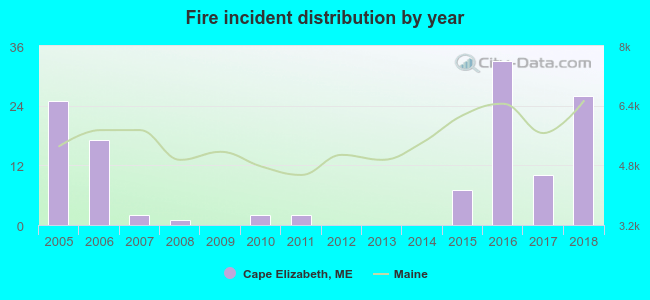 Based on the data from the years 2005 - 2018 the average number of fires per year is 9. The highest number of fire incidents - 33 took place in 2016, and the least - 0 in 2009. The data has a growing trend.
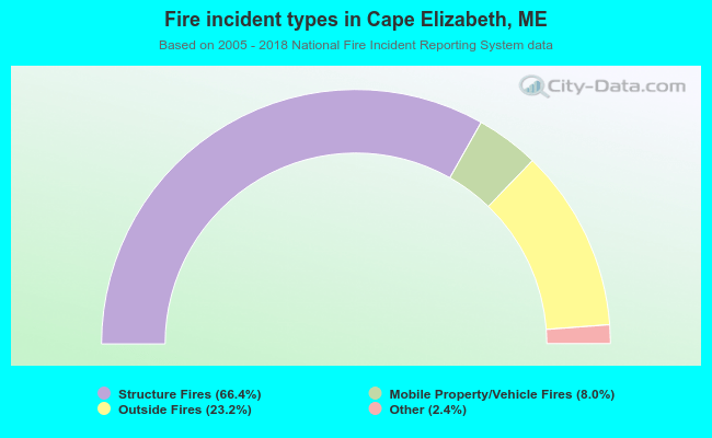 When looking into fire subcategories, the most reports belonged to: Structure Fires (66.4%), and Outside Fires (23.2%).
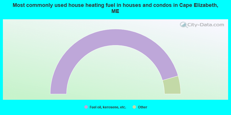
- 91.0%Fuel oil, kerosene, etc.
- 4.0%Bottled, tank, or LP gas
- 2.6%Utility gas
- 1.0%Wood
- 1.0%Electricity
- 0.4%Solar energy
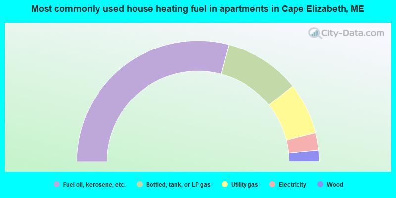
- 58.3%Fuel oil, kerosene, etc.
- 20.3%Bottled, tank, or LP gas
- 13.8%Utility gas
- 4.7%Electricity
- 3.0%Wood
Cape Elizabeth compared to Maine state average:
- Median household income above state average.
- Median house value above state average.
- Unemployed percentage significantly below state average.
- Black race population percentage significantly below state average.
- Renting percentage below state average.
- Length of stay since moving in significantly above state average.
- Number of rooms per house significantly below state average.
- House age significantly below state average.
- Percentage of population with a bachelor's degree or higher above state average.
Cape Elizabeth on our top lists:
- #7 on the list of "Top 101 cities with largest percentage of males in occupations: physicians and surgeons (population 5,000+)"
- #8 on the list of "Top 101 cities with largest percentage of females in occupations: counselors, social workers, and other community and social service specialists (population 5,000+)"
- #10 on the list of "Top 101 cities with largest percentage of females in occupations: social scientists and related workers (population 5,000+)"
- #16 on the list of "Top 101 cities with largest percentage of males in industries: health care (population 5,000+)"
- #17 on the list of "Top 101 cities with largest percentage of females in occupations: registered nurses (population 5,000+)"
- #22 on the list of "Top 101 cities with largest percentage of females in occupations: top executives (population 5,000+)"
- #25 on the list of "Top 101 cities with largest percentage of females in occupations: lawyers (population 5,000+)"
- #26 on the list of "Top 101 cities with largest percentage of females in industries: electronic shopping and mail-order houses (population 5,000+)"
- #27 on the list of "Top 101 cities with largest percentage of males in industries: water transportation (population 5,000+)"
- #28 on the list of "Top 101 cities with largest percentage of males in industries: used merchandise, gift, novelty, and souvenir, and other miscellaneous stores (population 5,000+)"
- #67 on the list of "Top 101 cities with largest percentage of males in industries: other direct selling establishments (population 5,000+)"
- #71 on the list of "Top 101 cities with the lowest number of assaults per 100,000 residents (population 5,000+)"
- #77 on the list of "Top 101 cities with largest percentage of males in industries: paper and paper products merchant wholesalers (population 5,000+)"
- #87 on the list of "Top 101 cities with largest percentage of females in industries: health care (population 5,000+)"
- #90 on the list of "Top 101 cities with largest percentage of males in industries: electronic shopping and mail-order houses (population 5,000+)"
- #97 on the list of "Top 101 cities with largest percentage of males in industries: office supplies and stationery stores (population 5,000+)"
- #98 on the list of "Top 101 cities with largest percentage of males in industries: management of companies and enterprises (population 5,000+)"
- #99 on the list of "Top 101 cities with largest percentage of males in industries: sporting goods, camera, and hobby and toy stores (population 5,000+)"
- #28 on the list of "Top 101 counties with the highest percentage of residents that exercised in the past month"
- #30 on the list of "Top 101 counties with the best general health status score of residents (1-5), 3 years of data"
- #40 on the list of "Top 101 counties with the highest percentage of residents that visited a dentist within the past year"
- #43 on the list of "Top 101 counties with the highest Nitrogen Dioxide air pollution readings in 2012 (ppm)"
- #49 on the list of "Top 101 counties with the lowest number of births per 1000 residents 2007-2013"

|
|
Total of 163 patent applications in 2008-2024.