The Norse exploration of southeast Canada and possibly the US is exciting because it's a time of discovery and exploration in the medieval period. In the period of the 10th-14th centuries, the Vikings interacted with Vinland, particularly for a few decades around 1000 AD. The Norse voyages provided practically the only literary knowledge of the Americas for the European community outside of possible scattered references to it, like the monk's journeys in the lost ~14th century Inventio Fortunata.
The
archaeological trail shows that the Vikings inhabited a settlement for about 10 years at
L'anse aux Meadows on the northern tip of Newfoundland. Archaeologists say that the site was used for ship repairs, and its geography conflicts with the geography of the four settlements named in the two Viking Sagas about Vinland, the Saga of the Greenlanders and the Saga of Eric the Red. The four settlements in those Sagas are Leifsbudir (Leif's Buildings), Straumsfjord (Current Fjord), Hop (Tidal Pool Estuary), and a cape between Straumsfjord and Hop where the VIkings cows grazed heavily.
Archaeologists found that the Vikings used
Jack Pine at their Greenland settlements, and that they had
butternuts at their site in L'anse aux Meadows. Today, Jack Pine grows only as far northeast as the St. Lawrence River, New Brunswick, and central Nova Scotia. Butternuts only grow as far northeast as Quebec City and New Brunswick, specifically a southern tributary of the Miramichi River that flows into the St. Lawrence Gulf and the St. John's River that flows into the Bay of Fundy. Scholars don't think that butternuts grew in Newfoundland in the Vikings' era, so these finds suggest that they went south, particularly to New Brunswick.
Archaeologists also found a Norse penny from the reign of Norwegian King Olaf Kyrre (reigned in 1067–1093 AD), called the
"Maine Penny," in a pile of Amerindian artefacts by an Amerindian village's ruins on the Atlantic coast near Brooklin, Maine. However, this discovery only shows that the Amerindians of Maine likely had a trade network running to the Vikings, not necessarily that the Vikings visited the site in Maine.
The Viking Sagas suggest that the Norse went perhaps as far west as the St. Lawrence River and the Hudson Valley of NY State, or conveivably as far southwest along the American coast to where they had a snowless winter in Eric the Red's Saga.
There are quite many purported remains and discoveries of artifacts that have been asserted as possibly Viking in origin, stretching from New York State to Newfoundland, but it's hard to know what to make of them without a sufficiently detailed and advanced study of the artefacts. One of these is the "Yarmouth Stone" that some consider to have a runic inscription. (
https://en.wikipedia.org/wiki/Yarmouth_Stone)


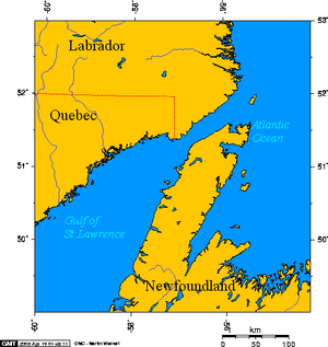
Above is a more exact Canadian map of the range of butternuts, in red.
The two Viking Sagas are fun to read, and scholars have a range on the locations in the two Sagas. The Sagas describe the Vikings sailing west to the stoney Helluland (Baffin Island), south to the wooded Markland (Labrador), and then to landmasses farther south.
The bear island to the southeast of Labrador in the Saga must be Belle Isle or Newfoundland, and
the Kjalarnes Peninsula must be either the northern end of Newfoundland or else northern or northeast Cape Breton. But all other locations south of Labrador in the Sagas seem ambiguous.
Eric the Red's Saga's Chapter 8 describes the journey from Brattahlid at the south end of Greenland to the lands south of Labrador the following way (Keep in mind that a wind is named after the direction that it comes from, so that "northerly winds" blow southward):
Quote:
During this time much talk took place in Brattahlid about making ready to go to Vinland the Good, and it was asserted that they would there find good choice lands... They sailed away from land; then to the Vestribygd [Greenland's Western Settlement] and to Bjarneyjar (the Bear Islands). Thence they sailed away from Bjarneyjar with northerly winds. They were out at sea two half-days. Then they came to land, and rowed along it in boats, and explored it, and found there flat stones, many and so great that two men might well lie on them stretched on their backs with heel to heel. Polar-foxes were there in abundance. This land they gave name to, and called it Helluland (stone-land).
Then they sailed with northerly winds two half-days, and there was then land before them, and on it a great forest and many wild beasts. An island lay in the south-east off the land, and they found bears thereon, and called the island Bjarney (Bear Island); but the mainland, where the forest was, they called Markland (forest-land). Then, when two half-days were passed, they saw land, and sailed under it. There was a cape to which they came. They cruised along the land, leaving it on the starboard side. There was a harbourless coast-land, and long sandy strands. They went to the land in boats, and found the keel of a ship, and called the place Kjalar-nes (Keelness). They gave also name to the strands, calling them Furdustrandir (wonder-shore), because it was tedious to sail by them.Then the coast became indented with creeks, and they directed their ships along the creeks.
Sephton's 1880 translation
|
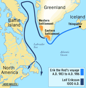
Brattahlid is the Viking's Greenland settlement at the end of the bright blue line in the map above.
Vestribygd means "Western Settlement," and it's also on the map.
Bjarneyjar by Greenland is thought by some scholars to refer to Disko Island, the island on Greenland's coast to the left of the "G" in Greenland.
Jon Johannesson theorizes in
A History of the Old Icelandic Commonwealth ; Islendinga Saga that Greenland's Bjarneyjar is Disko Island:
From an ancient description of Greenland it may be deduced that Bjarney was a name used for today's Disco Island. But so far no acceptable reason has been given for Thorfinnr Karlsefni's decision to begin his voyage by sailing in a direction opposite to that of Vinland. Perhaps the following facts offer an explanation: Disco is an island of basalt, about 1880 meters in height, capped with ice and snow and very clearly visible against the gneissic mountains to the south from a distance of more than eighty nautical miles in clear weather. This is more than a third of the distance between Bjarney (Disco Island) and Baffin Island. The author of Thorfinns Saga no doubt knew about this route even though it may not have been discovered until some time after the first voyages to the North American mainland. Even though sailors might have been unable to see the lands they were passing, the presence of land could be detected by the flight of certain birds.
The Disko Bay Arctic station blog asserts, "The old viking name of Disko Island is indeed Bear Island (Bjørn Øya)," and tells about polar bears there.
https://diskobayarcticstation.wordpr...and-bjorn-oya/
Fridtjof Nansen explains in his book "Northern Mists" that Greenland's Bjarneyjar, the Bear Islands, are on Greenland's coast to the west of the Western Settlement:
From the context [in Eric the Red's Saga] it would seem probable that these islands, or this island (?), lay in the Western Settlement. If they had been near Lysefjord, Karlsevne, as Storm points out, might be supposed to go there first because his wife, Gudrid, had inherited property there from Thorstein, and there might be much to fetch thence. But the name Bjarneyjar itself points rather to some place farther north, since the southern part of the Western Settlement (the Godthaab district) must have been then, as now, that part of the coast where bears were scarcest. In Björn Jónsson’s “Gronlandiæ vetus Chorographia” a “Biarney” (or “-eyiar”) is mentioned, to which it was twelve days’ rowing from Lysefjord [cf. above, p. 301], and as they are the only islands (or island ?) of this name mentioned on the west coast of Greenland, there is much in favour of their being the place here alluded to.
https://www.gutenberg.org/cache/epub...s.html#fna_299
Helluland means "Flat stone land" and scholars consider it to refer to Baffin Island.
Markland means "Outback Land" and scholars identify it with the Labrador Peninsula.
Bjarney, meaning "Bear Island" is the island with bears laying to the southeast of Markland/Labrador.
But identifying Bjarney in real world geography is a challenge. Belle Isle and Newfoundland are both literally islands to the southeast of Labrador.
In the map below, Belle Isle is the island at 52 degrees Latitude north of the A in the word Atlantic:
In their 1985 book The Norse Discovery of America, the Ingstads wrote:
"An occasional polar bear may also come south on the ice; while we were in Newfoundland , a polar bear was shot in the Strait of Belle Isle."
Sveinn Traustason writes in his thesis Visit Vinland:
If Markland refers to southeastern Labrador then the most obvious option for Bear Island ‘to the south-east’ is Belle Isle north of the Great Northern Peninsula. If, however, Markland refers to the whole northern shore of the Gulf of St. Lawrence, (i.e. Labrador and east Quebec), then Bear Island could refer to Anticosti Island, as Bergthorsson (2000) has suggested, adding that “Black bears are found on Anticosti, and the Native Americans called it ‘the land where bears are hunted’”, or it could potentially be one of the smaller islands along the coast e.g. Gros Mécatina or Mingan Islands.
Hans Peder Steensby in his book
Norsemen's Route from Greenland to Wineland asserts that Bjarney is Newfoundland.
If one were to compare the size of Greenland's Bjarneyar with potential sites for the Bjarney to the southeast of Markland, one could compare the size of Disko Island (3,312 mi²) with Belle Isle (20 mi²), Newfoundland (42,031 mi²), and Anticosti Island (3,071 mi²). Looking at a map of the Labrador Peninsula, Anticosti Island looks much more south than southeast of that Peninsula. Other islands along Labrador's south coast like the Mingan Islands are even smaller than Belle Island. The directional geography indicates much more strongly that Bjarney is Belle Isle or Newfoundland, because those are clearly "southeast" of Labrador.
Bjarney seems somewhat more likely to be Belle Isle than to be Newfoundland, because Newfoundland had Amerindians, not just bears, and because Newfoundland is about the size of Iceland (39,769 mi²). Due to its large size, Newfoundland seems less likely to be thought of as a mere outlying island on Labrador's coast comparable to the Bjarneyar on Greenland's west coast.
Kjalarnes means keelness, and a "nes" is a peninsula or point in Old Norse. It's named after the Vikings breaking or discovering a keel on land south of Newfoundland. Kjalarnes seems most likely to be narrowed down to a peninsula on the north end of Newfoundland, or on the north or northeast ends of Cape Breton.
Eric the Red's Saga actually comes in two separate, very similar versions, the Skálholtsbók and the Hauksbók. Scholars tend to consider the Skalhotsbok version to be more original. Svenn Jansson translates this Saga's journey from Helluland/Baffin Island to Kjalarnes as follows:
Skálholtsbók version
Then they sailed on a northerly wind for two days and then there was a land before them on which there was a great forest and many animals.
An island lay off the land to the southeast and there they found a bear and called [the place] Bjarney (‘Bear Island’). But the land they called Markland (‘Forest Land’) where the forest is.
When two days had passed they sighted land and they sailed along the coast. There was a promontory [ie. a "nes"]. When they got there they tacked along the coast, keeping the land to starboard.
There were wastes there and long, sandy beaches.
They go on boats to land and got shelter from a ship and called the place Kjalarnes (‘Keel Point’).
They also gave the coasts a name and called them Furustrandir (‘Wonder Beaches’) because it was a long way to sail down them.
Then the land became cut by bays and inlets and they steered [and they steered] the ships into the bays.
Hauksbók version
From there they sailed for two days and the wind shifted from south to southeast and they found a wooded land with many animals on it.
An island lay offshore to the southeast. There they killed a bear and from this called the place Bjarney and the land Markland.
From there they sailed south along the coast for a long time and came to a promontory. The land lay to starboard.
There were long, sandy beaches there.
They rowed to land and found there on the headland a ship’s keel and called the place Kjalarnes.
They also called the coasts Furðustrandir because it was a long way to sail down them.
Then the land became cut by bays and inlets. They steered the ships into a bay.
So in other words, they sailed south from Labrador for two days, got to a landmass, sailed along the coast to a cape, the land was on their boat's right side, and they called the cape Kjalarnes because they found a keel there. They kept sailing and got to long line of sandy beaches that they called Furustrandir (Wonder Beaches), and further down the land had many bays and inlets.
The Greenlanders' Saga gives the story of Cape Kjalarnes a little differently. In this Saga, Leif Erikson and the Vikings sail two days southwest from Labrador, instead of straight south as in Eric the Red's Saga, and come to a northward peninsula with a dewy island laying on its north, then sail west along the coast to a river and lake with salmon in them and make camp. They find grapes, call the land Vinland, and find a chain of islands and shallows on the western coast to the west of their salmon-river.
Later, Thorvald and his Vikings sail east from
Leifsbudir (Leif's buildings) and break their keel on a cape, and name the cape "Kjalarnes." In this Saga, it isn't clear if the northward cape with the dewy island that they saw when they sailed to Leif's camp is the same cape as Cape Kjalarnes. They repair their keel and sail east across the neighboring fjord to a nice-looking peninsula that they later call
"Krossanes" (Cross Point). They kill sleeping Amerindians in sands beyond the peninsula and come to hills in the fjord that were likely Amerindian homes. Amerindians come on canoes from inside the fjord and kill Thorvald. They bury Thorvald on the peninsula, make a cross in his memory there, and call the peninsula "Krossanes."
Chapters 4 in the Greenlanders' Saga gives the directions for Leif's camp this way, starting from the Vikings' departure from Markland/Labrador:
Quote:
Then said Leif, ‘This land shall have a name after its nature, and we will call it Markland.’ They returned to the ship and sailed away upon the main with north-east winds, and were out two days before they sighted land. They sailed toward this land, and came to an island which lay to the north of the land. There they went ashore and looked about them, the weather being fine, and they observed that there was dew upon the grass, and it so happened that they touched the dew with their hands, and touched their hands to their mouths, and it seemed to them that they had never before tasted anything so sweet as this.
They went aboard their ship again and sailed into a certain sound which lay between the island and a cape which jutted out from the land on the north, and they headed west past the cape. When the tide went out, there were broad reaches of shallow water there, and they stranded their ship there, and it was a long distance from the ship to the ocean; yet were they so anxious to go ashore that they could not wait until the tide should rise under their ship but hurried to the land where a certain river flows out from a lake. As soon as the tide rose beneath their ship, however, they took the boat and rowed to the ship, which they conveyed up the river, and so into the lake, where they cast anchor and carried their hammocks ashore from the ship, and built themselves booths there. Next, they decided to establish themselves there for the winter and built a large house. There was no lack of salmon there either in the river or in the lake, and larger salmon than they had ever seen before. The country seemed to be possessed of such good qualities that cattle would need no fodder during the winters. There was no frost there in the winters, and the grass withered very little. The days and nights there were of more nearly equal length than in Greenland or Iceland. On the shortest day of winter the sun was up between mid-morning and mid-afternoon.
(Adapted from Reeves' 1890 translation)
|
Here is an excerpt from S. Jansson's translation of Chapter 4:
Now they sail [from Markland] out into the ocean on a northeasterly wind, and were at sea for two days before they saw land, and sailed toward the shore and came to an island that lay north of the land, and landed there and had a look about them in good weather and found that there was dew on the grass, and by chance they put their hands in the dew and put it to their mouths and it seemed to them that they had never tasted anything as sweet as that was.
Then they went to their ship and sailed into the channel that lay between the island and a headland that extended north from the land. They headed in a westerly direction around the headland. At low tide there were extensive shallows and then their ship became beached, and from the ship the sea looked a long way off.
But their curiosity was so great to go ashore that they could not be bothered to wait for the sea to rise under their ship, and they ran to land where a river flowed out from a certain lake. But when the sea lifted their ship again, they took the boat and rowed to the ship and moved it up into the river and so into the lake, and dropped anchor there and carried their sleeping bags from the ship and made camp there.
Chapter 6 in the Greenlanders' Saga gives the directions from Leif's camp to the islands and shallows to the camp's west, and from Leif's camp to Krossanes this way:
Quote:
In the spring [at Leif's camp], Thorvald said that they should put their ship in order, and that a few men should take the after-boat and proceed along the western coast, and explore [the region] surrounding them during the summer. They found it a fair, well-wooded country; it was but a short distance from the woods to the sea, and [there were] white sands as well as great numbers of islands and shallows. They found neither dwelling of man nor animals; but in one of the westerly islands they found a wooden building for the shelter of grain. They found no other trace of human hands, and they turned back, and arrived at Leif’s camp in the autumn.
The following summer, Thorvald sailed out toward the east and along the northern coast. They were met by a high wind off a certain promontory and were driven ashore there, and damaged the keel of their ship, and had to remain there for a long time to repair the injury to their vessel. Then said Thorvald to his companions: ‘I propose that we raise the keel upon this cape, and call it Keel-point,’ and so they did. Then they sailed away to the east off the land and into the mouth of the adjoining fjord, and to a headland [Krossanes] which projected into the sea there, and which was entirely covered with woods.
(Adapted from Reeves' 1890 translation)
|
Here is Jansson's translation of Chapter 6:
But in the spring Þorvaldr said that they should see to their ship, and the ship’s boat and some of the men with it should go west along the coast and explore there through the summer. The land seemed beautiful to them and well wooded, with woods coming down close to the shore, and white sands. There were many islands there and wide shallows.
They found no signs of human habitation or animals anywhere, but on one island toward the west they found a corn rick made of wood. They found nothing else made by humans and turned back and arrived at Leifsbúðir in the autumn.
The second summer Þorvaldr went east with the ship and further north around the coast. Then they ran into sharp weather off a certain headland and were blown onto the shore there, and broke the keel from under the ship and they had a long stay there while they repaired their ship.
Then Þorvaldr said to his companions: ‘Now I want us to put up the keel here on the headland and we’ll call it Kjalarnes.’
And this they did.
Then they sail away from there and east along the coast and into the mouths of the bays that were closest at hand and to a cape that jutted out there. It was all covered with woods.
Later, in Chapter 9, Thorvall, another Viking, takes his ship to Kjalarnes and tries to sail west from it, but a storm blows his ship eastward all the way to Ireland. This story shows that Kjalarnes had a side on the Atlantic Ocean, so that the eastward storm blew Thorvall across the ocean. Additionally, since the Vikings reached Kjalarnes in Eric the Red's Saga by sailing south to it, these coordinates limit Kjalarnes' location to either the north end of Newfoundland or to Cape Breton's north or northeast peninsulas.
The Sagas' accounts raise challenges to identifying Kjalarnes and the other locations like
Leif's camp, the Wonderstrands, and Krossanes.
First, what were the departure points on Markland/Labrador for sailing southwest and south to the northward cape with the dewy island and to Kjalarnes, respectively? Perhaps these journeys were from the same departure point?
If one imagined Labrador to be like Greenland with a southward point at its south end, then one would easily guess that the departure point was at Labrador's south end. However, Labrador's peninsula points eastward in an overall triangular form, with its south side running in a slightly northeast direction.
As a result, it seems reasonable for the Vikings to have sailed south along Labrador's east coast and then departed the mainland southward or southwestward from where the coast starts to go southwest, like
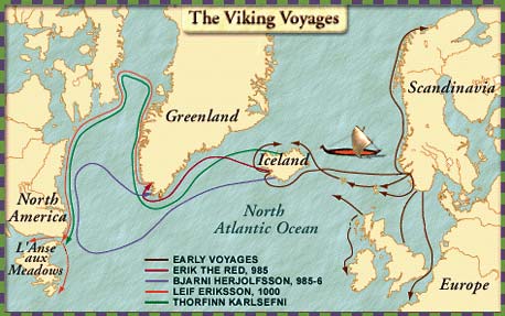
Labrador's coastline near Belle Isle. Since Eric the Red's Saga specifically gives special attention to Bjarney (likely Belle Isle), one can consider that it served as a likely departure point from the mainland just as Bjarneyar by Greeland served as a natural departure point to sail west to Baffin Island. If one considers the North Atlantic as a circle, with Greenland's southward point at the top and Europe in the east, one would find Labrador's east coast near Belle Isle as one of the eastward points, like near Cape Charles or at the western end fo the green arrow in the map below:
On the other hand, the Vikings were following a southwestward wind in the Greenlanders' Saga, and if one sails southwest from Labrador's east end, one would naturally arrive at a spot southwest on Labrador's coastline, like at Wolf Bay. This is because Labrador's coast runs in a southwest direction from Cape Charles to Wolf Bay, and this makes W
olf's Bay a natural departure point for the Vikings to use to sail south or southwest.
Technically, the Labrador Peninsula runs all the way westward from Wolf Bay into the St. Lawrence River's mouth, so the north side of the St. Lawrence River's mouth is a conceivable departure point. It's harder to picture the Vikings sailing from the west end of Labrador to get to Leif's camp and Kjalarnes, because the northward capes on the Gaspe' peninsula are not nearly as pronounced as those on the south side of the St. Lawrence Gulf. Further, it shouldn't take them as much as two days to cross the St. Lawrence River to get to the land on its south side.
A second challenge is finding the distance that the Vikings sailed in their two days' journeys southwest and south from Labrador across the sea to the capes. The slowest journey in the two Sagas from known points is the journey from Baffin Island to Labrador in the Greenlanders' Saga (100 miles in 3 days), and the quickest journey is from Greenland to Baffin Island in Eric the Red's Saga (250 miles in 2 days). Thus, the full range of distances for the two days' sailing journey southward from Labrador would be 66 miles to 250 miles.
In real history apart from the Sagas, Viking ships sailed an average of ~7 mph, or at an optimum rate of 11 mph. In 12 hours, this would come to 84 to 132 miles. Eric the Red's Saga technically refers to the Vikings making their journeys to Kjalarnes, Labrador, and Baffin Island as "two half-days" each, implying that they sailed for 24 hours total on each journey. At a rate of 7 to 11 mph, each journey's distance would run from 168 miles to 264 miles total. Sveinn Traustason, in his thesis "Visit Vinland," theorized that at an optimum sailing rate, the Vikings would cover 331 miles in 2 days.
On top of all of these distances, the Vikings could have a sighting range of up to 10 miles if they looked from their mast tops. So if they sailed for 66-264 miles and sighted land, the land would therefore be 76-274 miles from their departure point.
A third challenge is identifying the capes southwest and south of Labrador to which the Vikings arrived after their journeys. Since they reached the cape with the island by sailing southwest in the Greenlanders' Saga and Cape Kjalarnes by sailing southward in Eric the Red's Saga, these two capes must be different if the two Sagas' departure locations are the same, or if the southwestward journey's departure point is to the west of the southward journey's departure point.
Each of the possible southwest and southward journeys from Cape Charles and from Wolf Bay have aspects that match and possibly conflict with the descriptions in the Sagas. In the map of the St. Lawrence Gulf below, I chart possible courses using these two points.
 If one were to sail directly south from Cape Charles, Labrador
 to reenact the journey in Eric the Red's Saga, one would come to the north end of Newfoundland in well under 50 miles. In fact, the distance from Labrador to northern Newfoundland's closest coastline is 10.8 to 20 miles, and the distance from Belle Isle to Newfoundland is under 25 miles. By comparison, at 7 mph, one would sail 42 miles in just 6 hours, ie. only half of a "half-day" of Viking sailing. Alternately, one argument in favor of this being the Vikings' route southward from Labrador is that archaeologists found a settlement at L'anse aux Meadows that the Vikings apparently used for ship repairs. Some scholars associate L'anse aux Meadows with Kjalarnes, because of their common feature of ship repair, like when the VIkings repair their broken keel in the Greenlanders' Saga.
If one were to sail directly south from Wolf Bay, one would reach the north end of Cape Breton at a distance of a bit under 250 miles. In about another 50 miles, one would reach the northeast end of Cape Breton Island. However, this interpretation the journey in Eric the Red's Saga would mean that the Vikings narrowly missed Newfoundland on their journey, even though it's quite a large landmass for them to avoid.
If one were to sai 2 days southwest from the east end of Labrador to reenact the journey in the Greenlanders' Saga, there doesn't seem to be an obvious spot on Newfoundland's west coast with a northward cape with a small island by it that one would reach. One reason is that sailing in a 45° southwest direction from Labrador's east end would take one along Labrador's own south coast. Further, if one takes a more southward course than a 45° angle, one would seem most likely to reach the Newfoundland coast at a spot without a northward cape with an island by it. On the other hand, western Newfoundland does have a large number of river-lake systems with salmon in them, in resemblance of the salmon river-lake system near which Leif built his camp.
Alternately, if one were to sail directly southwest from Wolf Bay, one would first hit the edge of Anticosti Island in ~100 miles. Later, one would come to the northward cape at the east end of Miramichi Bay, or perhaps the northward cape at the east end of Chaleur Bay with Miscou Island to its north. Each of these two bays has their own commonalities and conflicts with the description of the waterways on the way to Leif's camp. The commonalities are that they each have salmon rivers, and that they are in New Brunswick, which has Jack Pines and Butternuts, both of which were unearthed at Viking settlements in Greenland and Newfoundland, respectively.
The first conflict is that the Greenlanders' Saga says that the Vikings didn't see any landmass until they came to the northward cape southwest of Labrador, but Anticosti Island would lay on their most direct southwestward path from Wolf Bay. The Saga suggests that they came to the dewy island by the northward cape after seeing the cape. This order of sighting the cape and then arriving at the dewy island in turn suggests that the island's shore that they reached was within 10 miles of the cape, because the Vikings had a sighting range of about 10 miles from the top of their masts. But Anticosti island is 150 miles or more from either bay.
Second, if the northward cape were the one east of Chaleur Bay, the dewy island by the cape could be Miscou Island. However, if the northward cape were the one east of Miramichi Bay, the dewy island's identity is less clear. Prince Edward Island is about 30 miles east of the cape at the end of Miramichi Bay, so the Vikings would have to first sail to Miramichi Bay and then sail down the coast further to get within sight of Prince Edward Island in order to make the order of landmass sightings to match the one in the Saga. This explanation seems a bit awkward. Miramichi Bay's mouth has a couple barrier islands close to the west of its cape, but the Saga sounds as if the dewy island was to the north of the northward cape, when the Saga suggests that they headed west past the cape only after getting to the dewy island.
Quote:
|
They went aboard their ship again [after visiting the dewy island] and sailed into a certain sound which lay between the island and a cape which jutted out from the land on the north, and they headed west past the cape.
|
Third, neither the rivers around Chaleur Bay nor those around Miramichi Bay flow from a literal "lake." The closest that one can see to a "lake" up their rivers are bulky parts of the rivers, particularly the bulky part below the first fork in the Miramichi River near the suburb of Newcastle.
Fourth, after camping at Leif's settlement in Chapter 6 of the Greenlanders' Saga, Thorvald decides to "proceed along the western coast, and explore [the region] surrounding them." The coast by Chaleur Bay and Miramichi Bay is an east-facing coast as it runs in a north-south direction. However, the Saga's reference to a "western coast" might just mean that the Vikings were exploring along the coast to the west of these bays, ie. along the southern shore of the St. Lawrence River as it runs westward to Quebec City.
So in conclusion, Kjalarnes must either be on the north end of Newfoundland, like in the general environment of L'anse aux Meadows, or else on the north to northeast end of Cape Breton Island, as these locations would be both reachable by sailing south from Labrador and on the Atlantic coast, so that one could sail east to Ireland from there.
Further, the possible range of locations for Leif's camp is much larger, and must be either on (A) Newfoundland's northernmost coast or its west coast, or on (B) the coastline on the south side of the St. Lawrence Gulf and River system, running northwest from Cape Breton Island's easternmost end west to Quebec City. For instance, one could sail in a direction that is much more southward than southwestern from a point between Cape Charles and Wolf Bay and arrive at the north end of Cape Breton, which has St. Paul Island about 10 miles to its northeast. From there, one could sail west along Nova Scotia's northwest coast and come to a number of salmon rivers like the Margaree River, which has Lake Ainslie to its south. Unfortunately, it seems quite difficult to get up the Margaree River to Lake Ainslie, which doesn't seem to have a large number of salmon in it anyway. The more strictly that one looks for literal salmon river-lake systems for Leif's camp, as opposed to flexibly counting saltwater inlets and bulks in rivers as river-lake systems, the more limited one's choices would be for possible sites for Leif's camp.

 Please register to participate in our discussions with 2 million other members - it's free and quick! Some forums can only be seen by registered members. After you create your account, you'll be able to customize options and access all our 15,000 new posts/day with fewer ads.