Welcome to City-Data.com Forum!
U.S. CitiesCity-Data Forum Index
Happy Mother`s Day to all Moms!
Go Back   City-Data Forum > General Forums > Weather > Hurricanes
 [Register]
Please register to participate in our discussions with 2 million other members - it's free and quick! Some forums can only be seen by registered members. After you create your account, you'll be able to customize options and access all our 15,000 new posts/day with fewer ads.
View detailed profile (Advanced) or search
site with Google Custom Search

Search Forums  (Advanced)
Reply Start New Thread
 
Old 06-30-2014, 09:53 PM
 
Location: Near the Coast SWCT
83,534 posts, read 75,373,979 times
Reputation: 16626

Advertisements

First one of season. They upgraded it to a depression. Most likely be a storm tommorow.


NWS NATIONAL HURRICANE CENTER MIAMI FL AL012014
1100 PM EDT MON JUN 30 2014

...TROPICAL DEPRESSIONS FORMS EAST OF FLORIDA...
...TROPICAL STORM WATCH ISSUED FOR THE COAST OF EAST-CENTRAL
FLORIDA...


SUMMARY OF 1100 PM EDT...0300 UTC...INFORMATION
-----------------------------------------------
LOCATION...27.6N 79.1W
ABOUT 105 MI...170 KM ESE OF CAPE CANAVERAL FLORIDA
ABOUT 210 MI...335 KM NNW OF THE NORTHWESTERN BAHAMAS
MAXIMUM SUSTAINED WINDS...35 MPH...55 KM/H
PRESENT MOVEMENT...SW OR 225 DEGREES AT 2 MPH...4 KM/H
MINIMUM CENTRAL PRESSURE...1009 MB...29.80 INCHES
Reply With Quote Quick reply to this message

 
Old 06-30-2014, 09:57 PM
 
Location: Near the Coast SWCT
83,534 posts, read 75,373,979 times
Reputation: 16626
Reply With Quote Quick reply to this message
 
Old 07-01-2014, 12:25 AM
 
Location: Arundel, FL
5,983 posts, read 4,279,873 times
Reputation: 2055
I wouldn't quite call it a tropical storm yet. I'm about 80 miles SW of it right now and it's completely calm.
Radar with projected path and satellite image from yesterday
Reply With Quote Quick reply to this message
 
Old 07-01-2014, 04:23 AM
 
Location: Near the Coast SWCT
83,534 posts, read 75,373,979 times
Reputation: 16626
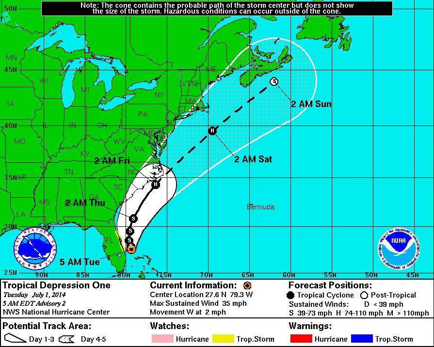
5am NHC Discussion Update: They are now expecting it to become a Hurricane. (Probably minimal)

NWS NATIONAL HURRICANE CENTER MIAMI FL
500 AM EDT TUE JUL 01 2014

...DEPRESSION LIKELY TO BECOME A TROPICAL STORM LATER TODAY...


SUMMARY OF 500 AM EDT...0900 UTC...INFORMATION
----------------------------------------------
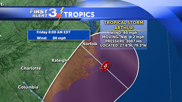
LOCATION...27.6N 79.3W
ABOUT 95 MI...155 KM SE OF CAPE CANAVERAL FLORIDA
ABOUT 215 MI...345 KM NNW OF THE NORTHWESTERN BAHAMAS
MAXIMUM SUSTAINED WINDS...35 MPH...55 KM/H
PRESENT MOVEMENT...W OR 260 DEGREES AT 2 MPH...4 KM/H
MINIMUM CENTRAL PRESSURE...1008 MB...29.77 INCHES


WATCHES AND WARNINGS

A TROPICAL STORM WATCH IS IN EFFECT FOR...
* EAST COAST OF FLORIDA FROM FORT PIERCE TO FLAGLER BEACH

A TROPICAL STORM WATCH MEANS THAT TROPICAL STORM CONDITIONS ARE
POSSIBLE WITHIN THE WATCH AREA...IN THIS CASE WITHIN 24 TO 36 HOURS.

---------------------

Reply With Quote Quick reply to this message
 
Old 07-01-2014, 04:50 AM
 
Location: Near the Coast SWCT
83,534 posts, read 75,373,979 times
Reputation: 16626
All models have this now.. Lock it in. Now it's a matter of what path it takes and the details of the storm

A look at Latest GFS, Canadian, Euro at Hour 90 and NAM at hr 84. GFS is closest to NJ coast and stays the closest northward.

Time frame is July 3rd in Southeast to July 5th in New England

Reply With Quote Quick reply to this message
 
Old 07-01-2014, 05:22 AM
nei nei won $500 in our forum's Most Engaging Poster Contest - Thirteenth Edition (Jan-Feb 2015). 

Over $104,000 in prizes has already been given out to active posters on our forum and additional contests are planned
 
Location: Western Massachusetts
45,983 posts, read 53,514,859 times
Reputation: 15184
will its path be mainly dependent on the strength of the Bermuda high?
Reply With Quote Quick reply to this message
 
Old 07-01-2014, 05:42 AM
 
Location: Near the Coast SWCT
83,534 posts, read 75,373,979 times
Reputation: 16626
Quote:
Originally Posted by nei View Post
will its path be mainly dependent on the strength of the Bermuda high?
Lots of factors. That High, the front, the trough.

Lets use the trough for example... Here's WPC's forecasted trough position on Friday the 4th of July In PURPLE.. The storm will ride along the flow of the right axis.

WHAT IF the trough dug down and tilted a little like in BLACK.... the storm goes OTS.
WHAT IF the trough isn't as strong and doesn't come to the coast in RED... the storm is closer to the coast.

Reply With Quote Quick reply to this message
 
Old 07-01-2014, 06:04 AM
 
Location: Near the Coast SWCT
83,534 posts, read 75,373,979 times
Reputation: 16626
Model Intensity. Most are just strong Tropical Storm status. A few into Minimal Hurricane strength.

This is NOT A BIG DEAL STORM... Might be a lot of hype out there due to the boredom weather we been having past couple months.

Rip Currents, Coastal Flooding Maybe, and a nice breeze is it. Maybe couple of weak trees come down near the coast.

I'll stay on top of any changes. NC would be the most watched state with this.

Reply With Quote Quick reply to this message
 
Old 07-01-2014, 09:01 AM
 
Location: Near the Coast SWCT
83,534 posts, read 75,373,979 times
Reputation: 16626
And Arthur is official born. 40mph winds near the center. They have it as a Hurricane on the Outer banks


Reply With Quote Quick reply to this message
 
Old 07-01-2014, 10:32 AM
 
Location: Near the Coast SWCT
83,534 posts, read 75,373,979 times
Reputation: 16626
Even with the closest model to the coast which I believe is the GFS right now. Here's the highest wind gusts it shows for Long Island/CT/NYC area.. 30-35mph gusts. NO BIG DEAL. And thats with the most west track.

Nantucket and MA capes get 35-40mph gusts on next frame. North Carolina outer banks up to 60mph possible

Reply With Quote Quick reply to this message
Please register to post and access all features of our very popular forum. It is free and quick. Over $68,000 in prizes has already been given out to active posters on our forum. Additional giveaways are planned.

Detailed information about all U.S. cities, counties, and zip codes on our site: City-data.com.


Reply
Please update this thread with any new information or opinions. This open thread is still read by thousands of people, so we encourage all additional points of view.

Quick Reply
Message:


Over $104,000 in prizes was already given out to active posters on our forum and additional giveaways are planned!

Go Back   City-Data Forum > General Forums > Weather > Hurricanes

All times are GMT -6.

© 2005-2024, Advameg, Inc. · Please obey Forum Rules · Terms of Use and Privacy Policy · Bug Bounty

City-Data.com - Contact Us - Archive 1, 2, 3, 4, 5, 6, 7, 8, 9, 10, 11, 12, 13, 14, 15, 16, 17, 18, 19, 20, 21, 22, 23, 24, 25, 26, 27, 28, 29, 30, 31, 32, 33, 34, 35, 36, 37 - Top