Please register to participate in our discussions with 2 million other members - it's free and quick! Some forums can only be seen by registered members. After you create your account, you'll be able to customize options and access all our 15,000 new posts/day with fewer ads.
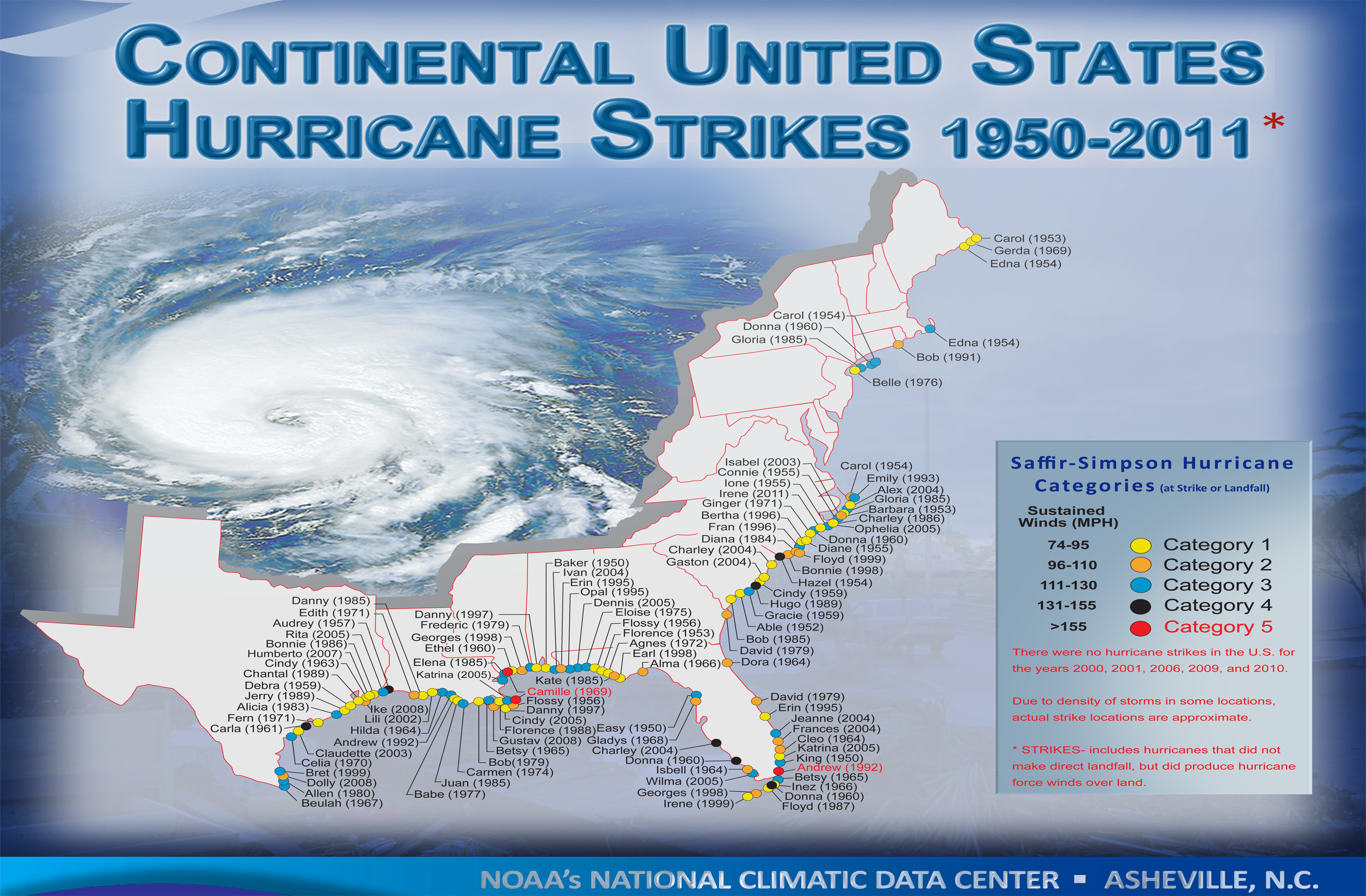
Very cool and finally someone who makes a large enough HiRes map. Long Island keeps blocking landfall here.
Fortunately for you Connecticut folk, Long Island is a lot longer in real life then on this flawed map ( )! The Island is almost as long as Connecticut.
Fortunately for you Connecticut folk, Long Island is a lot longer in real life then on this flawed map ( )! The Island is almost as long as Connecticut.
Hahaha! Just noticed that.
Looks like the map was made before Irene in 2011. No Sandy either.
Nevermind... I see Irene. Apparently they only do 1st landfalls.
Quote:
Originally Posted by LINative
Interesting to see that parts of southern Texas, western Louisiana, coastal Georgia and large parts of Florida have not had direct hits..
Kinda surprised to see none in DE or Maryland but understandable. Surprised at the West Florida gap between Alma 1966 and East 1950.
Cambium, it's showing Donna in Keys and then again on West Coast.
Ugh, it does! So why doesn't it show NJ for Irene............... ahhh, "Hurricanes" only. Not Tropical storms. Irene was a TS hitting NJ then another landfall in NYC
It show Katrina as a cat 5 at landfall when it wasn't.
Nah, it shows as Cat 3. View bigger chart and clear Katrina is pointing to blue dot, the red dot is for Camille. Lots of data plots so a bit hard to see. But all Cat 5 canes are shown in red letters; Camille and Andrew.
Nah, it shows as Cat 3. View bigger chart and clear Katrina is pointing to blue dot, the red dot is for Camille. Lots of data plots so a bit hard to see. But all Cat 5 canes are shown in red letters; Camille and Andrew.
Ok, I see what you are saying. Camille is actually pointing to 2 separate dots. I didn't see that initially. Thanks.
Please register to post and access all features of our very popular forum. It is free and quick. Over $68,000 in prizes has already been given out to active posters on our forum. Additional giveaways are planned.
Detailed information about all U.S. cities, counties, and zip codes on our site: City-data.com.

 Please register to participate in our discussions with 2 million other members - it's free and quick! Some forums can only be seen by registered members. After you create your account, you'll be able to customize options and access all our 15,000 new posts/day with fewer ads.


 )! The Island is almost as long as Connecticut.

