Please register to participate in our discussions with 2 million other members - it's free and quick! Some forums can only be seen by registered members. After you create your account, you'll be able to customize options and access all our 15,000 new posts/day with fewer ads.
Hi,
Am looking to purchase a home in Londonderry on Wilshire Drive.
We noticed a few planes overhead on Sunday when we looked at the house.
Some planes were flying lower and some higher than others.
Anyone know how loud the airplane noise is in that area and how often it might be?
Thanks
Last edited by catsnmusic; 06-01-2020 at 09:21 AM..
Hi catsnmusic (great username, btw). I'm not sure how well you know Londonderry, but the landing path for the north/south runway runs right along High Range Road, so the neighborhoods between High Range and Mammoth Roads are all affected to some degree. Wilshire Drive will see and hear airplanes as this neighborhood is just outside of the landing path (varied about .25 mile depending on conditions) but not too bad, as it is still a couple of miles south of the airport. At that point, they probably have wheels down, but once the planes cross over Pillsbury Road (connects High Range to Mammoth) they are in a straight line for the runway. When they are using the north/sough runway at MHT, you can expect planes every 5-10 minutes. I'll try to post a picture to show you the orientation of the runways to the house that you are looking at.
Here is an thread going back a few years, with a couple of interesting airplane pictures from one of the satellite maps (google maps, maybe) Very interesting: http://www.city-data.com/forum/new-h...nderry-nh.html
Quote:
Originally Posted by catsnmusic
Hi,
Am looking to purchase a home in Londonderry on Wilshire Drive.
We noticed a few planes overhead on Sunday when we looked at the house.
Some planes were flying lower and some higher than others.
Anyone know how loud the airplane noise is in that area and how often it might be?
Thanks
Last edited by Valerie C; 06-01-2020 at 01:34 PM..
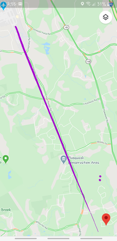
Here is a pic of the final approach path into MHT. The fix MNTIN as shown here is about a 5 mile final for 35, which is what the airplanes are required to be outside of when they are on a visual approach, which is most of the time. When the weather is bad, they will be on a longer final than that, which is depicted by the blue line.
So you will probably hear airplanes fairly often. Not every 5-10 min, though. Regardless, please don't be one of those people that moves into a house knowing there are airplanes flying over and then try to get the airport shut down.
Thanks for sharing a more accurate picture of the final approach than my roughly-drawn example. Looks like my pitch was a little off, too far west... Can you advise where to find the full approach? I'd love to see it, as we live within sight of what I believe is their final curve before the straight approach to MHT (where they are closer to Mammoth Road than to High Range, and it's interesting to see the range of their descent over Rte 102... ps: one of these days I'm going to time the arrivals
Thanks for sharing a more accurate picture of the final approach than my roughly-drawn example. Looks like my pitch was a little off, too far west... Can you advise where to find the full approach? I'd love to see it, as we live within sight of what I believe is their final curve before the straight approach to MHT (where they are closer to Mammoth Road than to High Range, and it's interesting to see the range of their descent over Rte 102... ps: one of these days I'm going to time the arrivals
I could show you a chart of the full approach, but it won't mean that much to you because there aren't really any ground based landmarks portrayed on them.
Also, I believe that ATC is required to alternate landings and take offs on each runway, assuming the wind isn't terribly strong, so that the noise is divided up between all of the communities under the approach and departure paths. During times of bad weather or high winds, this is not possible.
Please register to post and access all features of our very popular forum. It is free and quick. Over $68,000 in prizes has already been given out to active posters on our forum. Additional giveaways are planned.
Detailed information about all U.S. cities, counties, and zip codes on our site: City-data.com.

 Please register to participate in our discussions with 2 million other members - it's free and quick! Some forums can only be seen by registered members. After you create your account, you'll be able to customize options and access all our 15,000 new posts/day with fewer ads.