November 27-28, 2012 NorthEast Snowstorm (snowfall, record, temp, day)
Please register to participate in our discussions with 2 million other members - it's free and quick! Some forums can only be seen by registered members. After you create your account, you'll be able to customize options and access all our 15,000 new posts/day with fewer ads.
I'm confident there will be snow with this system. How much and where will depend on track as usual. I will be posting updates in here to keep the other thread uncluttered.
Basically the northern Jet digs down and is in place before the storm gets to the NorthEast. System starts in the Gulf States and produces a MillerB type storm exiting Mid Atlantic and moving up the coast.
Here are some tid bits on NWS Disucssions from around the area.
Upton:
Quote:
CHANCE POP DURING THE DAY ON TUE AND LASTING THROUGH WED AFTERNOON.
GENERALLY WENT WITH WINTRY PRECIP ACROSS INLAND AREAS...WITH
MOSTLY RAIN AT THE COAST. POSSIBLE WINTRY MIX OVER NYC WED EVENING
WITH ANY LINGERING PRECIP...THOUGH CONFIDENCE IN TEMPS AND EXACT
P-TYPE REMAINS LOW.
Boston:
Quote:
THERE IS A BIT MORE SUPPORT FOR A COASTAL STORM RATHER
THAN ONE THAT PUSHES INLAND. WILL ALSO CONTINUE TO SHOW SOME SNOWFALL POSSIBLE PARTICULARLY W OF THE I-495 AND I-95 CORRIDOR
Albany:
Quote:
SNOW AS THE PREDOMINANT PTYPE...WITH PERHAPS A MIX WITH
RAIN BEFORE THE BOUNDARY LAYER COOLS QUICKLY. THE 850 HPA TEMPS
STAY BELOW FREEZING ON THE EC/GFS AS FAR SOUTH AS LONG ISLAND...WITH
THE 925 HPA TEMP NEAR 0C CLOSE TO THE LOWER HUDSON VALLEY. OUR CONSENSUS RIGHT NOW IS FOR A LIGHT SNOW EVENT WITH A FEW INCHES POSSIBLE /LESS THAN 4"/
Concord:
Quote:
MODELS CONTINUE TO VARY WIDELY WHILE ATTEMPTING TO RESOLVE
UPCOMING SYSTEM TUESDAY NIGHT INTO WEDNESDAY.
THE GFS CONTINUES TO BRING A SURFACE LOW FROM THE NJ COASTLINE TUESDAY NIGHT...PASSING OFF CAPE COD WEDNESDAY MORNING. THIS IS THE MOST AGGRESSIVE
MODEL...
THE 00Z EURO DEPICTS A VERY WEAK SYSTEM WELL OF THE
EAST COAST.
THE CANADIAN GEM APPEARS TO BE SOMEWHAT OF A COMPROMISE...KEEPING A RELATIVELY ORGANIZED SURFACE LOW SEVERAL HUNDRED MILES EAST OF CAPE COD
Mt Holly:
Quote:
IT SHOULD BE SAID THAT THE ECMWF IS SHOWING A BIT MORE PHASING THAN IT HAD IN
PREVIOUS RUNS. THE GFS AND CANADIAN BRING THE IMPULSE INTO BETTER
PHASE WITH ENERGY TO THE NORTH, AND THEY DEVELOP A MORE ROBUST
SURFACE LOW.
ONE CAN COBBLE TOGETHER A SOLUTION THAT WOULD RESULT IN AT LEAST
SOME SNOW AS FAR SOUTHEAST AS THE AREA NEAR THE I-95 CORRIDOR
Reason why this storm was NOT going towards the Great Lakes.
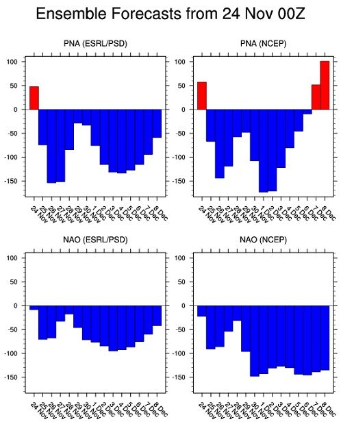
I introduce to you a very Negative NAO. Blocking! If you're in New England, I would keep an eye on this one. There could be areas that might get over half foot.
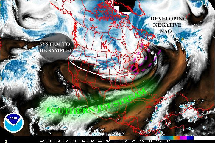
System now entering the West Coast. Important because now it will get sampled and put into the models. The 00z runs should have it which means tonights models.
That storm in the Atlantic will form our blocking up north. Isnt it cool to see the players on the map?
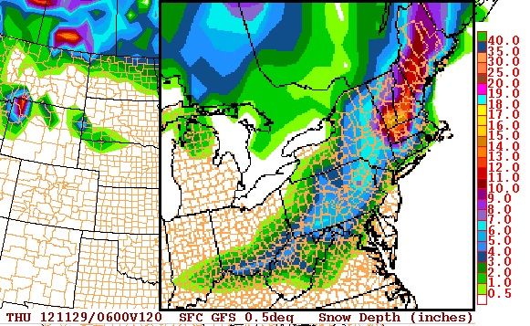
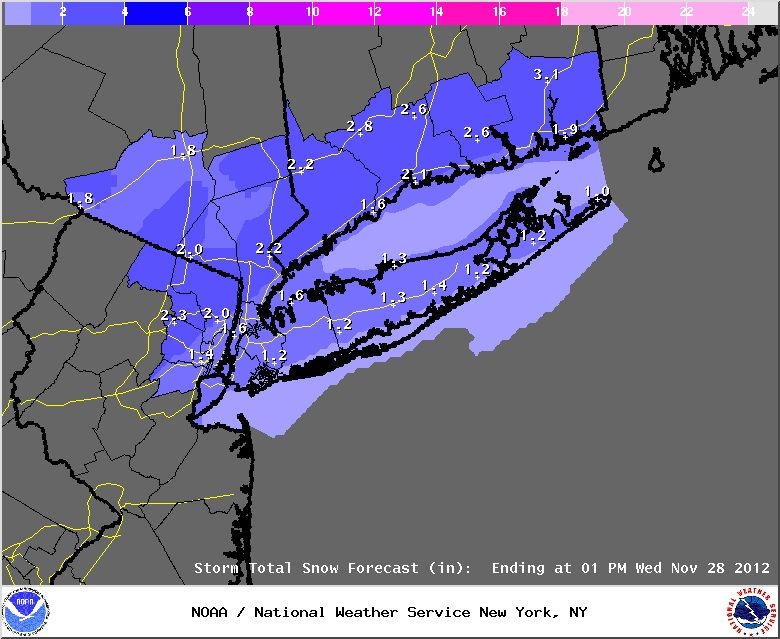
Quick update on this. Models having a weaker and more south wave now. Inland areas get nothing. But a swath of 3-5" still around from Baltimore to central NJ.
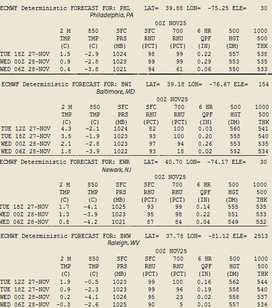
Here's the text output from the more reliable Euro model for these select locations.
It snowed last night in Elkins wv where I am going on winter vacation this year!! according to accuweather.com there could be another snow system on dec 8-11 to!! keeping fingers crossed!
After finally sampling the system on the west coast, models have ingested the new data and trended south with the system.
If it taps into the gulf moisture feed results will be slightly more but for now here's what NWS thinks. Inland areas dont get anything because the track went south more.
Snow starts Tuesday afternoon. Not a big deal event at this moment.
If this happens, another record will be broken. 2 snowstorms in November more than a trace have NEVER happened for coastal CT!!
Please register to post and access all features of our very popular forum. It is free and quick. Over $68,000 in prizes has already been given out to active posters on our forum. Additional giveaways are planned.
Detailed information about all U.S. cities, counties, and zip codes on our site: City-data.com.

 Please register to participate in our discussions with 2 million other members - it's free and quick! Some forums can only be seen by registered members. After you create your account, you'll be able to customize options and access all our 15,000 new posts/day with fewer ads.