Dec 27-29, 2015 Storm (snowfall, warm, ice, Chicago)
Please register to participate in our discussions with 2 million other members - it's free and quick! Some forums can only be seen by registered members. After you create your account, you'll be able to customize options and access all our 15,000 new posts/day with fewer ads.
Could it be the beginning of a pattern change? A sign?
4 days ago we had a transfer off the Maine coast from a storm that tracked to the Great Lakes then into Quebec.
In November we had no transfers.
Now For the first time, I'm seeing a potential storm go from the South to Tennessee and Mid Atlantic NOT from the south to the Great Lakes!
What that's means is .. Instead of warm air rising from the south and getting a front only, High Pressure in Quebec can feed cold air down and also allow for the Jet stream to push down in the East. In other words.. Snow chances.
First... Storm tomorrow heading to Great Lakes.. (What else is new?) But lacking precip except when it goes to Ontario
Light snow for UP Michigan.
Then,... Thursday... a little more dig and another storm that goes to the Great Lakes (What else is new!) This has some good moisture. Snows for Iowa (what else is new!?!) and Minnesota. Chicago missing out on the warm side of things
So as you can see the active stormy pattern is continuing which seems to have started about back in Early November?
Now we have to see if the pattern shifts to Transfers instead of Lake cutters. That will keep things interesting for New England especially for snowstorms. We'll see
Andrew has a write up on it... lets keep our fingers crossed
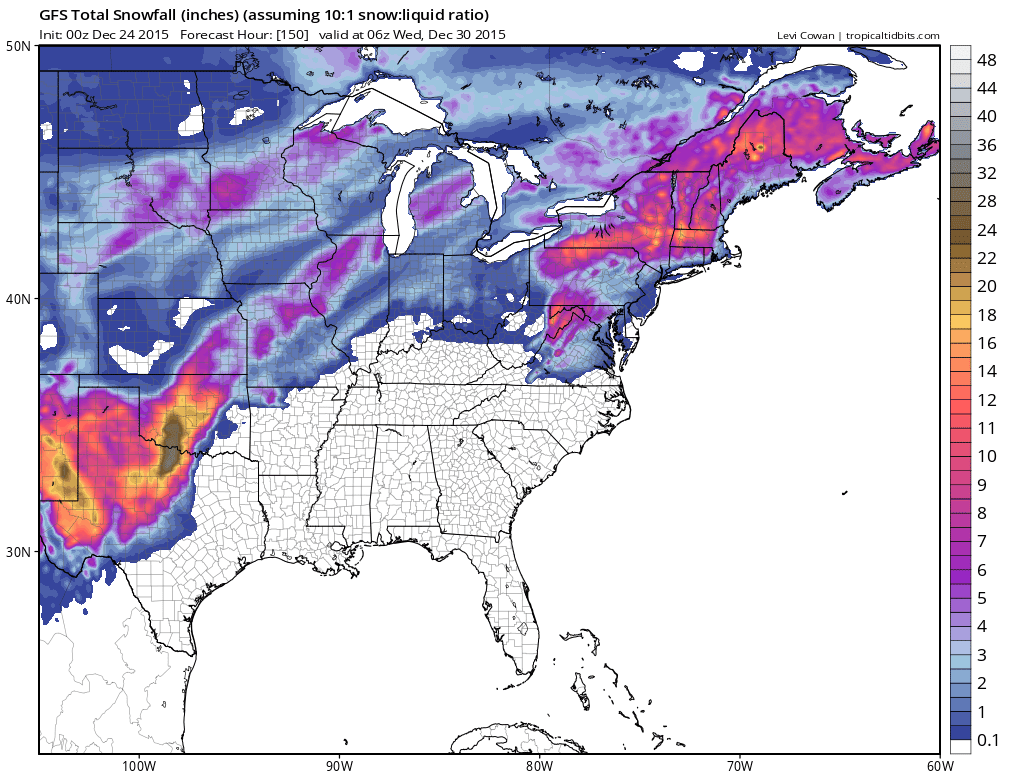
Thanks for keeping the thread going CG! Wish I had more time. Been peaking at the models and to my amazement they ALL are colder with snow now. GFS, EURO, GGEM.
Merry Christmas... Welcome to New England.
Fresh Strong High Pressure to the north = CAD! Add moisture and you got SNOW!
2 important factors I learned once to get snow. Strong Quebec High and "Fresh". Its not a HP that has been sitting there for days, this will be fresh cold air.
With that said.. NWS NY changed its tune. But other factors need to fall in place of course. Funny cause they downplayed it this morning. Now all models show colder and snow and they do a 180. "SIGNIFICANT" snow is "POSSIBLE" here if...
Quote:
NATIONAL WEATHER SERVICE NEW YORK NY
719 PM EST THU DEC 24 2015
THE STRONG HIGH WILL BE CENTERED OVER
NEW ENGLAND...AND IN A GOOD POSITION FOR COLD AIR DAMMING TO SET
UP AND SUPPLY COLD LOW LEVEL AIR TO THE REGION LATE MON NIGHT
INTO TUE. MODEL GUIDANCE HAS TRENDED COLDER ALOFT...WITH H7-8
TEMPS REMAINING BELOW 0C AT LEAST UNTIL AFTERNOON...WHEN STRONG
S-SW FLOW AT H7-8 SHOULD BRING IN ENOUGH WARM AIR ALOFT.
WITH LOW TEMPS FROM THE MID 20S INLAND...TO LOWER/MID 30S ALONG
THE COAST AND IN NYC METRO...MOST AREAS SHOULD AT LEAST SEE SOME
MIXED PCPN LATE MON NIGHT/TUE MORNING BEFORE A CHANGE TO RAIN BY
TUE AFTERNOON AND INTO TUE NIGHT. HOWEVER...IF WARMER AIR ALOFT IS
DELAYED...INTERIOR SECTIONS MAY HAVE A SHOT AT SEEING THE FIRST
SIGNIFICANT SNOWFALL OF THE SEASON...WHILE AREAS JUST TO THE
SOUTH...INCLUDING COASTAL CT TO JUST NW OF NYC...COULD HAVE A PD
OF ACCUMULATING SNOW BEFORE A CHANGE TO RAIN. HAVE HIGHLIGHTED
POTENTIAL FOR SIGNIFICANT SNOWFALL FOR INTERIOR SECTIONS
ONLY ATTM
Please register to post and access all features of our very popular forum. It is free and quick. Over $68,000 in prizes has already been given out to active posters on our forum. Additional giveaways are planned.
Detailed information about all U.S. cities, counties, and zip codes on our site: City-data.com.

 Please register to participate in our discussions with 2 million other members - it's free and quick! Some forums can only be seen by registered members. After you create your account, you'll be able to customize options and access all our 15,000 new posts/day with fewer ads.