Bridge Statistics for Alameda, California (CA)
Condition, Traffic, Stress, Structural Evaluation, Project Costs
- National Bridge Inventory (NBI) Statistics
- 11Number of bridges
- 584ft / 178mTotal length
- $1,932,000Total costs
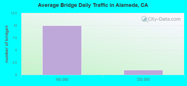
- 418,057Total average daily traffic
- 43,868Total average daily truck traffic
- National Bridge Inventory (NBI) Registered Bridges for Alameda
- No street view available for this location
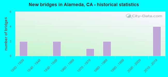
- New bridges - historical statistics
- 21930-1939
- 21950-1959
- 11970-1979
- 21980-1989
- 42010-2019
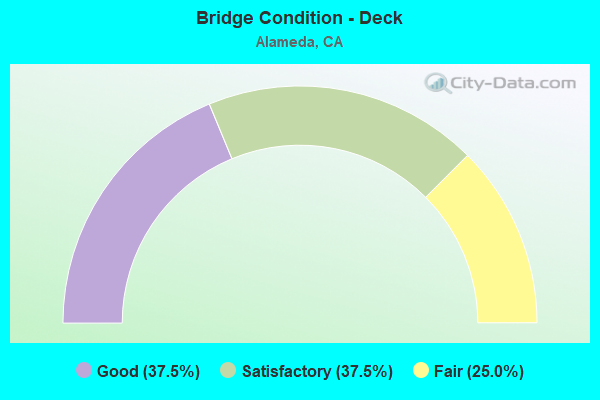
- Bridge Condition - Deck
- 37.5%Good
- 37.5%Satisfactory
- 25.0%Fair
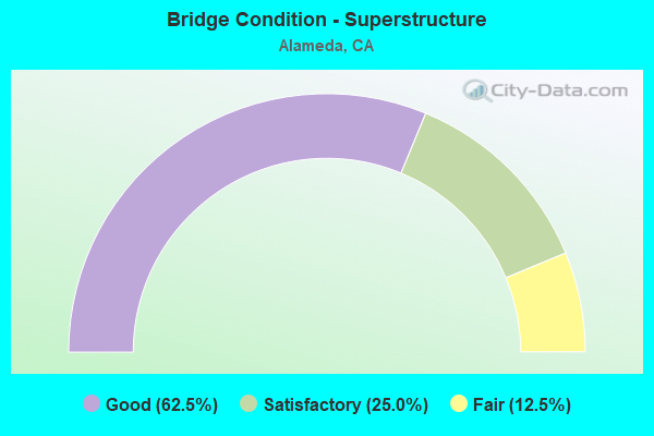
- Bridge Condition - Superstructure
- 62.5%Good
- 25.0%Satisfactory
- 12.5%Fair
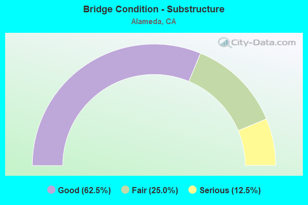
- Bridge Condition - Substructure
- 62.5%Good
- 25.0%Fair
- 12.5%Serious
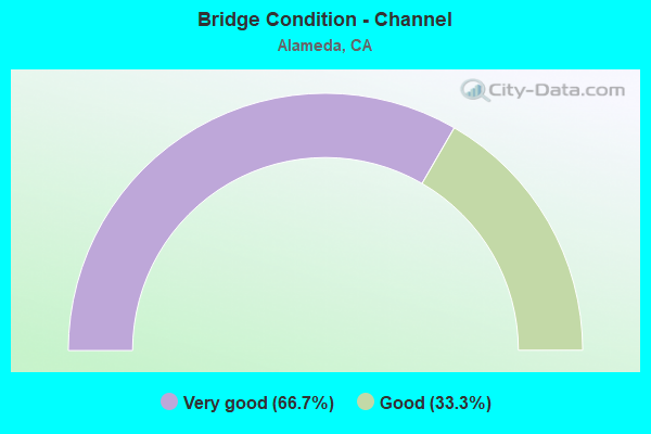
- Bridge Condition - Channel
- 66.7%Very good
- 33.3%Good
Find on map >> Show street view
Structure Number: 33 0086, Location: 04-ALA-061-18.55-ALA (Lat: 37.747453, Lng: -122.236008), Route carried "on" structure: State highway 61, Year Built: 1953, Status: Open, Structure Length: 29.35m (96.29ft), Average Daily Traffic: 43,600 (year 2019), Truck Traffic: 5%, Average Future Daily Traffic: 87,200 (year 2038), Design Load: HS 20, Features Intersected: SAN LEANDRO BAY
Minimum Vertical Clearance: 30+ m (98+ ft), Kilometerpoint: 18.550, Lanes on structure: 4, Base Highway Network: Yes (, Subroute: 1), Owner: State Highway Agency, Approaching Roadway Width: 17.7m (58.1ft), Skew: 20 degrees, Navigation Control: Yes ( Vertical Clearance: 6.4m (21.0ft), Horizontal Clearance: 28.3m (92.8ft)), Material/Design: Steel, Design/Construction: Movable - Bascule, Number Of Spans In Main Unit: 1, Number Of Approach Spans: 21, Length of Maximum Span: 31.9m (104.7ft), Curb or Sidewalk Widths: Left: 1.5m (4.9ft), Right: 0.6m (2.0ft), Curb-To-Curb Width: 15.8m (51.8ft), Out-to-Out Width: 19.9m (65.3ft)
Condition: Deck: Fair, Superstructure: Fair, Substructure: Fair, Channel: Good, Operating Rating: 46.7 metric tons, Method Used To Determine Operating Rating: Load Factor (LF), Inventory Rating: 27.9 metric tons, Method Used To Determine Inventory Rating: Load Factor (LF), Structural Evaluation: Somewhat better than minimum adequacy, Deck Geometry: Meets minimum limits, Waterway Adequacy: Better than present minimum criteria, Approach Roadway Alignment: Meets minimum limits, Designated Inspection Frequency: Every 24 months, Critical Feature Inspection Frequency: Every 24 months, Underwater Inspection Frequency: Every 60 months, Inspection Date: March 2021, Critical Feature Inspection Date: October 2020, Underwater Inspection Date: May 2020, Deck Structure Type: Open Grating
Find on map >> Show street view
Structure Number: 33 0513K, Location: 04-ALA-260-R0.86L-ALA (Lat: 37.782914, Lng: -122.275517), Route carried "on" structure: Ramp State highway 260, Year Built: 1985, Status: Open, Structure Length: 26.64m (87.40ft), Average Daily Traffic: 1,001 (year 2011), Truck Traffic: 2%, Average Future Daily Traffic: 4,000 (year 2038), Features Intersected: STATE ROUTE 260 NB
Minimum Vertical Clearance: 30+ m (98+ ft), Kilometerpoint: 0.860, Lanes on structure: 2, Lanes under structure: 1, Owner: State Highway Agency, Approaching Roadway Width: 9.7m (31.8ft), Material/Design: Prestressed concrete continuous, Design/Construction: Box Beam or Girders - Multiple, Number Of Spans In Main Unit: 3, Number Of Approach Spans: 20, Length of Maximum Span: 40.2m (131.9ft), Curb-To-Curb Width: 9.7m (31.8ft), Out-to-Out Width: 11.2m (36.7ft)
Condition: Deck: Good, Superstructure: Good, Substructure: Good, Operating Rating: 59.9 metric tons, Method Used To Determine Operating Rating: Field evaluation and documented engineering judgment, Inventory Rating: 36.0 metric tons, Method Used To Determine Inventory Rating: Field evaluation and documented engineering judgment, Structural Evaluation: Better than present minimum criteria, Deck Geometry: Somewhat better than minimum adequacy, Underclear: Better than present minimum criteria, Approach Roadway Alignment: Equal to present minimum criteria, Designated Inspection Frequency: Every 24 months, Inspection Date: March 2021, Deck Structure Type: Concrete Cast-file-Place
Find on map >> Show street view
Structure Number: 33 075, Location: 04-ALA-092-R6.03-HAY (Lat: 37.639381, Lng: -122.097294), Route carried "on" structure: City street , Year Built: 2011, Status: Open, Structure Length: 6.34m (20.80ft), Average Daily Traffic: 8,500 (year 2010), Truck Traffic: 4%, Average Future Daily Traffic: 10,724 (year 2043), Design Load: HS 20, Features Intersected: STATE ROUTE 92 & RAMP, Facility Carried by Structure: CALAROGA AVE
Minimum Vertical Clearance: 30+ m (98+ ft), Kilometerpoint: 0.000, Lanes on structure: 2, Lanes under structure: 9, Owner: State Highway Agency, Approaching Roadway Width: 12.2m (40.0ft), Material/Design: Prestressed concrete continuous, Design/Construction: Box Beam or Girders - Multiple, Number Of Spans In Main Unit: 2, Length of Maximum Span: 33.1m (108.6ft), Curb or Sidewalk Widths: Left: 1.5m (4.9ft), Right: 1.5m (4.9ft), Curb-To-Curb Width: 12.2m (40.0ft), Out-to-Out Width: 15.8m (51.8ft)
Condition: Deck: Good, Superstructure: Satisfactory, Substructure: Good, Operating Rating: 54.1 metric tons, Method Used To Determine Operating Rating: Assigned rating based on Load Factor Design (LFD) reported in metric tons, Inventory Rating: 32.4 metric tons, Method Used To Determine Inventory Rating: Assigned rating based on Load Factor Design (LFD) reported in metric tons, Structural Evaluation: Equal to present minimum criteria, Deck Geometry: Somewhat better than minimum adequacy, Underclear: High priority of corrective action, Approach Roadway Alignment: Equal to present desirable criteria, Designated Inspection Frequency: Every 24 months, Inspection Date: September 2021, Deck Structure Type: Concrete Cast-file-Place
Find on map >> Show street view
Structure Number: 33 0754, Location: 04-ALA-880-30.38-ALA (Lat: 37.789853, Lng: -122.256553), Route carried "on" structure: State highway 880, Year Built: 2013, Status: Open, Structure Length: 72.70m (238.52ft), Average Daily Traffic: 240,000 (year 2013), Truck Traffic: 14%, Average Future Daily Traffic: 306,050 (year 2043), Design Load: HS 20+Mod, Features Intersected: UP RR, BNSF, AMTRAK, 5TH
Minimum Vertical Clearance: 30+ m (98+ ft), Kilometerpoint: 30.380, Lanes on structure: 8, Lanes under structure: 4, Base Highway Network: Yes, Owner: State Highway Agency, Approaching Roadway Width: 48.0m (157.5ft), Skew: 1 degrees, Material/Design: Prestressed concrete continuous, Design/Construction: Box Beam or Girders - Multiple, Number Of Spans In Main Unit: 17, Length of Maximum Span: 47.0m (154.2ft), Curb-To-Curb Width: 45.6m (149.6ft), Out-to-Out Width: 47.1m (154.5ft)
Condition: Deck: Good, Superstructure: Good, Substructure: Good, Channel: Very good, Operating Rating: 54.1 metric tons, Method Used To Determine Operating Rating: Assigned rating based on Load Factor Design (LFD) reported in metric tons, Inventory Rating: 32.4 metric tons, Method Used To Determine Inventory Rating: Assigned rating based on Load Factor Design (LFD) reported in metric tons, Structural Evaluation: Better than present minimum criteria, Deck Geometry: Superior to present desirable criteria, Underclear: Superior to present desirable criteria, Waterway Adequacy: Better than present minimum criteria, Approach Roadway Alignment: Equal to present desirable criteria, Designated Inspection Frequency: Every 24 months, Inspection Date: Febuary 2021, Deck Structure Type: Concrete Cast-file-Place
Find on map >> Show street view
Structure Number: 33C0026, Location: 0.4 MI S/W OF I-880 (Lat: 37.764008, Lng: -122.225475), Route carried "on" structure: County highway , Year Built: 1939, Status: Open, Structure Length: 15.40m (50.52ft), Average Daily Traffic: 19,900 (year 2014), Truck Traffic: 10%, Average Future Daily Traffic: 23,282 (year 2041), Features Intersected: OAKLAND ESTUARY, Facility Carried by Structure: HIGH ST
Minimum Vertical Clearance: 4.39m (14.40ft), Kilometerpoint: 0.000, Lanes on structure: 2, Owner: County Highway Agency, Approaching Roadway Width: 8.8m (28.9ft), Navigation Control: Yes ( Vertical Clearance: 5.5m (18.0ft), Horizontal Clearance: 73.2m (240.2ft)), Material/Design: Steel, Design/Construction: Movable - Bascule, Number Of Spans In Main Unit: 3, Number Of Approach Spans: 6, Length of Maximum Span: 90.0m (295.3ft), Curb or Sidewalk Widths: Left: 1.5m (4.9ft), Right: 1.5m (4.9ft), Curb-To-Curb Width: 7.3m (24.0ft), Out-to-Out Width: 7.9m (25.9ft)
Condition: Deck: Satisfactory, Superstructure: Good, Substructure: Serious, Channel: Very good, Operating Rating: 62.5 metric tons, Method Used To Determine Operating Rating: Load Factor (LF), Inventory Rating: 42.8 metric tons, Method Used To Determine Inventory Rating: Allowable Stress (AS), Structural Evaluation: High priority of corrective action, Deck Geometry: High priority of replacement, Waterway Adequacy: Superior to present desirable criteria, Approach Roadway Alignment: Equal to present minimum criteria, Length Of Structure Improvement: 15.40m (50.52ft), Designated Inspection Frequency: Every 24 months, Critical Feature Inspection Frequency: Every 24 months, Inspection Date: April 2021, Critical Feature Inspection Date: June 2020, Bridge Improvement Cost: $1,150,000, Roadway Improvement Cost: $230,000, Total Project Cost: $1,932,000 ( Estimate for 2017), Deck Structure Type: Open Grating
Find on map >> Show street view
Structure Number: 33C0027, Location: 0.2 MI S/W OF I-880 (Lat: 37.771164, Lng: -122.236875), Route carried "on" structure: County highway , Year Built: 1934, Status: Open, Structure Length: 13.20m (43.31ft), Average Daily Traffic: 41,000 (year 2014), Truck Traffic: 5%, Average Future Daily Traffic: 33,260 (year 2041), Design Load: HS 20, Features Intersected: OAKLAND ESTUARY, Facility Carried by Structure: PARK ST
Minimum Vertical Clearance: 4.11m (13.48ft), Kilometerpoint: 0.000, Lanes on structure: 4, Owner: County Highway Agency, Approaching Roadway Width: 14.6m (47.9ft), Navigation Control: Yes ( Vertical Clearance: 5.5m (18.0ft), Horizontal Clearance: 73.2m (240.2ft)), Material/Design: Steel, Design/Construction: Movable - Bascule, Number Of Spans In Main Unit: 3, Number Of Approach Spans: 5, Length of Maximum Span: 87.0m (285.4ft), Curb or Sidewalk Widths: Left: 2.0m (6.6ft), Right: 2.0m (6.6ft), Curb-To-Curb Width: 14.2m (46.6ft), Out-to-Out Width: 14.6m (47.9ft)
Condition: Deck: Satisfactory, Superstructure: Good, Substructure: Good, Channel: Very good, Operating Rating: 52.2 metric tons, Method Used To Determine Operating Rating: Load Factor (LF), Inventory Rating: 31.4 metric tons, Method Used To Determine Inventory Rating: Load Factor (LF), Structural Evaluation: Better than present minimum criteria, Deck Geometry: High priority of replacement, Waterway Adequacy: Superior to present desirable criteria, Approach Roadway Alignment: Equal to present minimum criteria, Designated Inspection Frequency: Every 24 months, Critical Feature Inspection Frequency: Every 24 months, Inspection Date: April 2021, Critical Feature Inspection Date: June 2020, Deck Structure Type: Open Grating
Find on map >> Show street view
Structure Number: 33C0147, Location: 0.3 MI S/W OF I-880 (Lat: 37.768475, Lng: -122.230533), Route carried "on" structure: County highway , Year Built: 1974, Status: Open, Structure Length: 12.04m (39.50ft), Average Daily Traffic: 20,800 (year 2014), Truck Traffic: 10%, Average Future Daily Traffic: 23,281 (year 2041), Design Load: HS 20, Features Intersected: OAKLAND ESTUARY, Facility Carried by Structure: FRUITVALE AVE
Minimum Vertical Clearance: 30+ m (98+ ft), Kilometerpoint: 0.000, Lanes on structure: 4, Owner: County Highway Agency, Approaching Roadway Width: 15.8m (51.8ft), Navigation Control: Yes ( Vertical Clearance: 6.4m (21.0ft), Horizontal Clearance: 29.0m (95.1ft)), Material/Design: Steel, Design/Construction: Movable - Bascule, Number Of Spans In Main Unit: 1, Number Of Approach Spans: 4, Length of Maximum Span: 39.0m (128.0ft), Curb or Sidewalk Widths: Left: 1.5m (4.9ft), Right: 1.5m (4.9ft), Curb-To-Curb Width: 15.8m (51.8ft), Out-to-Out Width: 19.6m (64.3ft)
Condition: Deck: Fair, Superstructure: Good, Substructure: Fair, Channel: Very good, Operating Rating: 50.9 metric tons, Method Used To Determine Operating Rating: Load Factor (LF), Inventory Rating: 30.5 metric tons, Method Used To Determine Inventory Rating: Load Factor (LF), Structural Evaluation: Somewhat better than minimum adequacy, Deck Geometry: Meets minimum limits, Waterway Adequacy: Superior to present desirable criteria, Approach Roadway Alignment: Equal to present minimum criteria, Designated Inspection Frequency: Every 24 months, Critical Feature Inspection Frequency: Every 24 months, Underwater Inspection Frequency: Every 60 months, Inspection Date: April 2021, Critical Feature Inspection Date: October 2020, Underwater Inspection Date: May 2020, Deck Structure Type: Concrete Cast-file-Place, Wearing Surface/Protective System: Wearing Surface: Epoxy Overlay
Find on map >> Show street view
Structure Number: 33C0229, Location: 0.1 MI N/E OF OTIS DR (Lat: 37.763617, Lng: -122.261497), Route carried "on" structure: City street , Year Built: 1958, Status: Open, Structure Length: 1.89m (6.20ft), Average Daily Traffic: 7,156 (year 2011), Truck Traffic: 4%, Average Future Daily Traffic: 6,564 (year 2042), Design Load: HS 20, Features Intersected: ALAMEDA LAKE, Facility Carried by Structure: GRAND ST
Minimum Vertical Clearance: 30+ m (98+ ft), Kilometerpoint: 0.000, Lanes on structure: 2, Owner: City or Municipal Highway Agency, Approaching Roadway Width: 14.6m (47.9ft), Material/Design: Concrete continuous, Design/Construction: Slab, Number Of Spans In Main Unit: 3, Length of Maximum Span: 9.1m (29.9ft), Curb or Sidewalk Widths: Left: 1.2m (3.9ft), Right: 1.4m (4.6ft), Curb-To-Curb Width: 19.5m (64.0ft), Out-to-Out Width: 23.0m (75.5ft)
Condition: Deck: Satisfactory, Superstructure: Satisfactory, Substructure: Good, Channel: Good, Operating Rating: 99.8 metric tons, Method Used To Determine Operating Rating: Load Factor (LF), Inventory Rating: 69.0 metric tons, Method Used To Determine Inventory Rating: Load Factor (LF), Structural Evaluation: Equal to present minimum criteria, Deck Geometry: Superior to present desirable criteria, Waterway Adequacy: Equal to present desirable criteria, Approach Roadway Alignment: Equal to present desirable criteria, Designated Inspection Frequency: Every 48 months, Inspection Date: November 2020, Deck Structure Type: Concrete Cast-file-Place
Find on map >> Show street view
Structure Number: 33 0513K, Location: 04-ALA-260-R0.86L-ALA (Lat: 37.782914, Lng: -122.275517), Route carried "under" structure: State highway 260, Year Built: 1985, Structure Length: 0. m, Average Daily Traffic: 16,100 (year 2019), Truck Traffic: 2%, Features Intersected: STATE ROUTE 260 NB
Minimum Vertical Clearance: 5.15m (16.90ft), Kilometerpoint: 0.860, Lanes on structure: 2, Lanes under structure: 1, Material/Design: Prestressed concrete continuous, Design/Construction: Box Beam or Girders - Multiple, Length of Maximum Span: 40.2m (131.9ft)
Find on map >> Show street view
Structure Number: 33 0754, Location: 04-ALA-880-30.38-ALA (Lat: 37.789853, Lng: -122.256553), Route carried "under" structure: City street , Year Built: 2013, Structure Length: 0. m, Average Daily Traffic: 10,000 (year 2014), Truck Traffic: 5%, Features Intersected: UP RR, BNSF, AMTRAK, 5TH, Facility Carried by Structure: INTERSTATE 880
Minimum Vertical Clearance: 8.96m (29.40ft), Kilometerpoint: 0.000, Lanes on structure: 8, Lanes under structure: 2, Material/Design: Prestressed concrete continuous, Design/Construction: Box Beam or Girders - Multiple, Length of Maximum Span: 47.0m (154.2ft)
Find on map >> Show street view
Structure Number: 33 0754, Location: 04-ALA-880-30.38-ALA (Lat: 37.789853, Lng: -122.256553), Route carried "under" structure: Ramp State highway 880, Year Built: 2013, Structure Length: 0. m, Average Daily Traffic: 10,000 (year 2014), Truck Traffic: 5%, Features Intersected: UP RR, BNSF, AMTRAK, 5TH
Minimum Vertical Clearance: 5.40m (17.72ft), Kilometerpoint: 30.300, Lanes on structure: 8, Lanes under structure: 2, Material/Design: Prestressed concrete continuous, Design/Construction: Box Beam or Girders - Multiple, Length of Maximum Span: 47.0m (154.2ft)