Bridge Statistics for Albion, Michigan (MI)
Condition, Traffic, Stress, Structural Evaluation, Project Costs
- National Bridge Inventory (NBI) Statistics
- 29Number of bridges
- 262ft / 79.6mTotal length
- $654,000Total costs
- 288,351Total average daily traffic
- 59,362Total average daily truck traffic
- National Bridge Inventory (NBI) Registered Bridges for Albion
- No street view available for this location
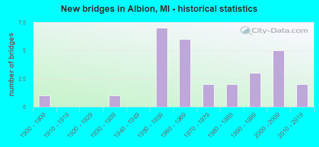
- New bridges - historical statistics
- 11900-1909
- 11930-1939
- 71950-1959
- 61960-1969
- 21970-1979
- 21980-1989
- 31990-1999
- 52000-2009
- 22010-2019

- Reconstructed bridges - Historical Statistics
- 11970-1979
- 11980-1989


- Bridge Condition - Deck
- 23.8%Good
- 52.4%Satisfactory
- 14.3%Fair
- 4.8%Poor
- 4.8%Serious

- Bridge Condition - Superstructure
- 14.3%Very good
- 19.0%Good
- 23.8%Satisfactory
- 28.6%Fair
- 14.3%Poor

- Bridge Condition - Substructure
- 9.5%Very good
- 47.6%Good
- 38.1%Satisfactory
- 4.8%Poor

- Bridge Condition - Channel
- 6.3%Very good
- 31.3%Good
- 37.5%Satisfactory
- 25.0%Fair
Find on map >> Show street view
Structure Number: 1282, Location: 8.9 MI E OF I-69 (Lat: 42.283336, Lng: -84.828183), Route carried "on" structure: County highway , Year Built: 1959, Status: Open, Structure Length: 6.93m (22.74ft), Average Daily Traffic: 160 (year 1988), Truck Traffic: 3%, Average Future Daily Traffic: 218 (year 2000), Design Load: H 15, Features Intersected: I-94, Facility Carried by Structure: 24 MILE ROAD
Minimum Vertical Clearance: 30.48m (100.00ft), Kilometerpoint: 1.028, Lanes on structure: 2, Lanes under structure: 4, Owner: State Highway Agency, Approaching Roadway Width: 6.4m (21.0ft), Material/Design: Concrete continuous, Design/Construction: Tee Beam, Number Of Spans In Main Unit: 4, Length of Maximum Span: 21.6m (70.9ft), Curb-To-Curb Width: 7.3m (24.0ft), Out-to-Out Width: 9.6m (31.5ft)
Condition: Deck: Satisfactory, Superstructure: Fair, Substructure: Satisfactory, Operating Rating: 51.8 metric tons, Method Used To Determine Operating Rating: Load Factor (LF) rating reported by rating factor (RF) method using MS18 loading, Inventory Rating: 31.1 metric tons, Method Used To Determine Inventory Rating: Load Factor (LF) rating reported by rating factor (RF) method using MS18 loading, Structural Evaluation: Somewhat better than minimum adequacy, Deck Geometry: Somewhat better than minimum adequacy, Underclear: Meets minimum limits, Approach Roadway Alignment: Better than present minimum criteria, Length Of Structure Improvement: 6.92m (22.70ft), Designated Inspection Frequency: Every 24 months, Inspection Date: August 2021, Bridge Improvement Cost: $80,000, Roadway Improvement Cost: $8,000, Total Project Cost: $94,000, Deck Structure Type: Concrete Cast-file-Place, Wearing Surface/Protective System: Wearing Surface: Latex Concrete
Find on map >> Show street view
Structure Number: 1283, Location: 4.8 MI W OF JACKSON COL (Lat: 42.283592, Lng: -84.800908), Route carried "on" structure: State highway 199, Year Built: 1960, Status: Posted for load, Structure Length: 6.92m (22.70ft), Average Daily Traffic: 1,000 (year 2011), Truck Traffic: 8%, Average Future Daily Traffic: 1,403 (year 2018), Design Load: H 15, Features Intersected: I-94
Minimum Vertical Clearance: 30.48m (100.00ft), Kilometerpoint: 1.909, Lanes on structure: 2, Lanes under structure: 4, Owner: State Highway Agency, Approaching Roadway Width: 6.7m (22.0ft), Material/Design: Concrete continuous, Design/Construction: Tee Beam, Number Of Spans In Main Unit: 4, Length of Maximum Span: 21.6m (70.9ft), Curb-To-Curb Width: 9.1m (29.9ft), Out-to-Out Width: 10.1m (33.1ft)
Condition: Deck: Fair, Superstructure: Fair, Substructure: Satisfactory, Operating Rating: 47.6 metric tons, Method Used To Determine Operating Rating: Load Factor (LF) rating reported by rating factor (RF) method using MS18 loading, Inventory Rating: 28.5 metric tons, Method Used To Determine Inventory Rating: Load Factor (LF) rating reported by rating factor (RF) method using MS18 loading, Structural Evaluation: Somewhat better than minimum adequacy, Deck Geometry: Equal to present minimum criteria, Underclear: High priority of corrective action, Approach Roadway Alignment: Better than present minimum criteria, Bridge Posting: Required (Relationship of Operating Rating to Maximum Legal Load: 0.1 - 9.9% below), Designated Inspection Frequency: Every 12 months, Inspection Date: August 2021, Deck Structure Type: Concrete Cast-file-Place, Wearing Surface/Protective System: Wearing Surface: Latex Concrete
Find on map >> Show street view
Structure Number: 1285, Location: 2.0 MI W OF JACKSON COL (Lat: 42.264083, Lng: -84.756367), Route carried "on" structure: Business Interstate 94, Year Built: 2001, Status: Open, Structure Length: 7.74m (25.39ft), Average Daily Traffic: 7,892 (year 2007), Truck Traffic: 7%, Average Future Daily Traffic: 9,493 (year 2018), Design Load: HS 25 or greater, Features Intersected: I-94
Minimum Vertical Clearance: 30.48m (100.00ft), Kilometerpoint: 17.847, Lanes on structure: 5, Lanes under structure: 5, Base Highway Network: Yes (Inventory Route: 129, Subroute: 2), Owner: State Highway Agency, Approaching Roadway Width: 16.7m (54.8ft), Material/Design: Prestressed concrete, Design/Construction: Box Beam or Girders - Multiple, Number Of Spans In Main Unit: 2, Length of Maximum Span: 39.3m (128.9ft), Curb-To-Curb Width: 24.7m (81.0ft), Out-to-Out Width: 25.3m (83.0ft)
Condition: Deck: Satisfactory, Superstructure: Fair, Substructure: Good, Operating Rating: 97.2 metric tons, Method Used To Determine Operating Rating: Load Factor (LF) rating reported by rating factor (RF) method using MS18 loading, Inventory Rating: 44.1 metric tons, Method Used To Determine Inventory Rating: Load Factor (LF) rating reported by rating factor (RF) method using MS18 loading, Structural Evaluation: Somewhat better than minimum adequacy, Deck Geometry: Superior to present desirable criteria, Underclear: Somewhat better than minimum adequacy, Approach Roadway Alignment: Equal to present desirable criteria, Designated Inspection Frequency: Every 24 months, Inspection Date: June 2021, Deck Structure Type: Concrete Cast-file-Place, Wearing Surface/Protective System: Wearing Surface: Monolithic Concrete, Deck Protection: Epoxy Coated Reinforcing
Find on map >> Show street view
Structure Number: 1286, Location: 1.0 MI W OF JACKSON COL (Lat: 42.264703, Lng: -84.736797), Route carried "on" structure: County highway , Year Built: 1960, Status: Open, Structure Length: 6.92m (22.70ft), Average Daily Traffic: 2,053 (year 1995), Truck Traffic: 3%, Average Future Daily Traffic: 2,361 (year 2000), Design Load: H 15, Features Intersected: I-94, Facility Carried by Structure: 29 MILE ROAD
Minimum Vertical Clearance: 30.48m (100.00ft), Kilometerpoint: 2.324, Lanes on structure: 2, Lanes under structure: 4, Owner: State Highway Agency, Approaching Roadway Width: 6.9m (22.6ft), Material/Design: Concrete continuous, Design/Construction: Tee Beam, Number Of Spans In Main Unit: 4, Length of Maximum Span: 21.6m (70.9ft), Curb or Sidewalk Widths: Left: 0.9m (3.0ft), Right: 0.9m (3.0ft), Curb-To-Curb Width: 7.9m (25.9ft), Out-to-Out Width: 11.1m (36.4ft)
Condition: Deck: Satisfactory, Superstructure: Satisfactory, Substructure: Satisfactory, Operating Rating: 53.1 metric tons, Method Used To Determine Operating Rating: Load Factor (LF) rating reported by rating factor (RF) method using MS18 loading, Inventory Rating: 31.8 metric tons, Method Used To Determine Inventory Rating: Load Factor (LF) rating reported by rating factor (RF) method using MS18 loading, Structural Evaluation: Equal to present minimum criteria, Deck Geometry: High priority of corrective action, Underclear: Meets minimum limits, Approach Roadway Alignment: Better than present minimum criteria, Length Of Structure Improvement: 6.92m (22.70ft), Designated Inspection Frequency: Every 24 months, Inspection Date: August 2021, Bridge Improvement Cost: $80,000, Roadway Improvement Cost: $8,000, Total Project Cost: $94,000, Deck Structure Type: Concrete Cast-file-Place, Wearing Surface/Protective System: Wearing Surface: Latex Concrete
Find on map >> Show street view
Structure Number: 1287, Location: S LTS OF ALBION (Lat: 42.236194, Lng: -84.753094), Route carried "on" structure: State highway 99, Year Built: 2011, Status: Open, Structure Length: 4.27m (14.01ft), Average Daily Traffic: 1,620 (year 2011), Truck Traffic: 12%, Average Future Daily Traffic: 1,780 (year 2031), Design Load: Greater than HL93, Features Intersected: S BR KALAMAZOO RIVER
Minimum Vertical Clearance: 30.48m (100.00ft), Kilometerpoint: 10.289, Lanes on structure: 2, Owner: State Highway Agency, Approaching Roadway Width: 15.0m (49.2ft), Material/Design: Prestressed concrete, Design/Construction: Box Beam or Girders - Single/Spread, Number Of Spans In Main Unit: 2, Length of Maximum Span: 20.8m (68.2ft), Curb or Sidewalk Widths: Left: 0.0m, Right: 1.5m (4.9ft), Curb-To-Curb Width: 13.9m (45.6ft), Out-to-Out Width: 16.7m (54.8ft)
Condition: Deck: Good, Superstructure: Satisfactory, Substructure: Good, Channel: Fair, Operating Rating: 73.9 metric tons, Method Used To Determine Operating Rating: Load Factor (LF), Inventory Rating: 44.2 metric tons, Method Used To Determine Inventory Rating: Load Factor (LF), Structural Evaluation: Equal to present minimum criteria, Deck Geometry: Superior to present desirable criteria, Waterway Adequacy: Equal to present desirable criteria, Approach Roadway Alignment: Equal to present desirable criteria, Designated Inspection Frequency: Every 24 months, Underwater Inspection Frequency: Every 60 months, Inspection Date: September 2021, Underwater Inspection Date: June 2017, Deck Structure Type: Concrete Cast-file-Place, Wearing Surface/Protective System: Wearing Surface: Monolithic Concrete, Deck Protection: Epoxy Coated Reinforcing
Find on map >> Show street view
Structure Number: 1288, Location: IN ALBION (Lat: 42.245756, Lng: -84.753031), Route carried "on" structure: State highway 99, Year Built: 1908, Year Reconstructed: 1993, Status: Open, Structure Length: 3.11m (10.20ft), Average Daily Traffic: 7,449 (year 2007), Truck Traffic: 3%, Average Future Daily Traffic: 9,998 (year 2018), Design Load: HS 25 or greater, Features Intersected: KALAMAZOO RIVER
Minimum Vertical Clearance: 30.48m (100.00ft), Kilometerpoint: 11.351, Lanes on structure: 4, Owner: State Highway Agency, Approaching Roadway Width: 19.2m (63.0ft), Material/Design: Prestressed concrete, Design/Construction: Box Beam or Girders - Single/Spread, Number Of Spans In Main Unit: 2, Length of Maximum Span: 15.5m (50.9ft), Curb or Sidewalk Widths: Left: 5.3m (17.4ft), Right: 5.0m (16.4ft), Curb-To-Curb Width: 19.2m (63.0ft), Out-to-Out Width: 30.1m (98.8ft)
Condition: Deck: Satisfactory, Superstructure: Satisfactory, Substructure: Satisfactory, Channel: Fair, Operating Rating: 59.6 metric tons, Method Used To Determine Operating Rating: Load Factor (LF) rating reported by rating factor (RF) method using MS18 loading, Inventory Rating: 35.3 metric tons, Method Used To Determine Inventory Rating: Load Factor (LF) rating reported by rating factor (RF) method using MS18 loading, Structural Evaluation: Equal to present minimum criteria, Deck Geometry: Equal to present minimum criteria, Waterway Adequacy: Equal to present desirable criteria, Approach Roadway Alignment: Equal to present desirable criteria, Designated Inspection Frequency: Every 24 months, Inspection Date: September 2021, Deck Structure Type: Concrete Cast-file-Place, Wearing Surface/Protective System: Wearing Surface: Monolithic Concrete, Deck Protection: Epoxy Coated Reinforcing
Find on map >> Show street view
Structure Number: 1304, Location: ALBION TWP SEC 17 (Lat: 42.202853, Lng: -84.794178), Route carried "on" structure: County highway , Year Built: 1959, Status: Posted for load, Structure Length: 2.92m (9.58ft), Average Daily Traffic: 388 (year 1995), Truck Traffic: 12%, Average Future Daily Traffic: 694 (year 2023), Design Load: H 15, Features Intersected: S BR KALAMAZOO RIVER, Facility Carried by Structure: F DR S
Minimum Vertical Clearance: 30.48m (100.00ft), Kilometerpoint: 6.182, Lanes on structure: 2, Owner: County Highway Agency, Approaching Roadway Width: 8.2m (26.9ft), Skew: 1 degrees, Material/Design: Prestressed concrete, Design/Construction: Box Beam or Girders - Multiple, Number Of Spans In Main Unit: 2, Length of Maximum Span: 14.6m (47.9ft), Curb or Sidewalk Widths: Left: 0.6m (2.0ft), Right: 0.6m (2.0ft), Curb-To-Curb Width: 8.2m (26.9ft), Out-to-Out Width: 9.7m (31.8ft)
Condition: Deck: Satisfactory, Superstructure: Poor, Substructure: Good, Channel: Good, Operating Rating: 23.7 metric tons, Method Used To Determine Operating Rating: Load Factor (LF) rating reported by rating factor (RF) method using MS18 loading, Inventory Rating: 14.3 metric tons, Method Used To Determine Inventory Rating: Load Factor (LF) rating reported by rating factor (RF) method using MS18 loading, Structural Evaluation: Meets minimum limits, Deck Geometry: Somewhat better than minimum adequacy, Waterway Adequacy: Equal to present desirable criteria, Approach Roadway Alignment: Equal to present desirable criteria, Bridge Posting: Required (Relationship of Operating Rating to Maximum Legal Load: > 39.9% below), Designated Inspection Frequency: Every 12 months, Inspection Date: September 2021, Deck Structure Type: Concrete Precast Panels, Wearing Surface/Protective System: Wearing Surface: Bituminous
Find on map >> Show street view
Structure Number: 1336, Location: SHERIDAN TWP SEC 17 (Lat: 42.297800, Lng: -84.799667), Route carried "on" structure: County highway , Year Built: 1998, Status: Posted for load, Structure Length: 0.79m (2.59ft), Average Daily Traffic: 490 (year 1995), Truck Traffic: 12%, Average Future Daily Traffic: 877 (year 2023), Design Load: HS 20, Features Intersected: RICE CREEK, Facility Carried by Structure: 26 MI ROAD
Minimum Vertical Clearance: 30.48m (100.00ft), Kilometerpoint: 3.507, Lanes on structure: 2, Owner: County Highway Agency, Approaching Roadway Width: 6.7m (22.0ft), Material/Design: Wood or Timber, Design/Construction: Slab, Number Of Spans In Main Unit: 1, Length of Maximum Span: 7.9m (25.9ft), Curb-To-Curb Width: 11.0m (36.1ft), Out-to-Out Width: 11.6m (38.1ft)
Condition: Deck: Good, Superstructure: Good, Substructure: Good, Channel: Fair, Operating Rating: 48.9 metric tons, Method Used To Determine Operating Rating: Allowable Stress (AS) rating reported by rating factor (RF) method using MS18 loading, Inventory Rating: 34.3 metric tons, Method Used To Determine Inventory Rating: Allowable Stress (AS) rating reported by rating factor (RF) method using MS18 loading, Structural Evaluation: Better than present minimum criteria, Deck Geometry: Better than present minimum criteria, Waterway Adequacy: Equal to present desirable criteria, Approach Roadway Alignment: Equal to present minimum criteria, Bridge Posting: Required (Relationship of Operating Rating to Maximum Legal Load: 10.0 - 19.9% below), Designated Inspection Frequency: Every 24 months, Inspection Date: July 2021, Deck Structure Type: Wood or Timber, Wearing Surface/Protective System: Wearing Surface: Bituminous
Find on map >> Show street view
Structure Number: 1342, Location: 1 MI S OF ALBION (Lat: 42.217472, Lng: -84.782133), Route carried "on" structure: County highway , Year Built: 1964, Status: Open, Structure Length: 2.68m (8.79ft), Average Daily Traffic: 195 (year 1994), Truck Traffic: 5%, Average Future Daily Traffic: 364 (year 2024), Design Load: H 20, Features Intersected: S BRANCH KALAMAZOO RIVER, Facility Carried by Structure: D DRIVE SOUTH
Minimum Vertical Clearance: 30.48m (100.00ft), Kilometerpoint: 9.444, Lanes on structure: 2, Owner: County Highway Agency, Approaching Roadway Width: 8.5m (27.9ft), Material/Design: Prestressed concrete, Design/Construction: Box Beam or Girders - Multiple, Number Of Spans In Main Unit: 2, Length of Maximum Span: 13.4m (44.0ft), Curb-To-Curb Width: 7.2m (23.6ft), Out-to-Out Width: 7.4m (24.3ft)
Condition: Deck: Satisfactory, Superstructure: Satisfactory, Substructure: Good, Channel: Satisfactory, Inventory Rating: 67.2 metric tons, Method Used To Determine Inventory Rating: Load Factor (LF), Structural Evaluation: Equal to present minimum criteria, Deck Geometry: Meets minimum limits, Waterway Adequacy: Better than present minimum criteria, Approach Roadway Alignment: Equal to present desirable criteria, Length Of Structure Improvement: 3.47m (11.38ft), Designated Inspection Frequency: Every 24 months, Inspection Date: September 2020, Deck Structure Type: Concrete Precast Panels, Wearing Surface/Protective System: Wearing Surface: Bituminous
Find on map >> Show street view
Structure Number: 1379, Location: 2 MI W OF ALBION (Lat: 42.261503, Lng: -84.807114), Route carried "on" structure: County highway , Year Built: 1970, Status: Posted for load, Structure Length: 2.13m (6.99ft), Average Daily Traffic: 1,740 (year 1994), Truck Traffic: 5%, Average Future Daily Traffic: 3,246 (year 2024), Design Load: HS 20+Mod, Features Intersected: KALAMAZOO RIVER, Facility Carried by Structure: B DRIVE NORTH
Minimum Vertical Clearance: 30.48m (100.00ft), Kilometerpoint: 12.114, Lanes on structure: 2, Owner: County Highway Agency, Approaching Roadway Width: 10.0m (32.8ft), Skew: 1 degrees, Material/Design: Wood or Timber, Design/Construction: Slab, Number Of Spans In Main Unit: 3, Length of Maximum Span: 7.9m (25.9ft), Curb-To-Curb Width: 9.6m (31.5ft), Out-to-Out Width: 10.0m (32.8ft)
Condition: Deck: Fair, Superstructure: Fair, Substructure: Satisfactory, Channel: Good, Operating Rating: 45.0 metric tons, Method Used To Determine Operating Rating: Load Factor (LF), Inventory Rating: 32.0 metric tons, Method Used To Determine Inventory Rating: Load Factor (LF), Structural Evaluation: Somewhat better than minimum adequacy, Deck Geometry: Somewhat better than minimum adequacy, Waterway Adequacy: Equal to present desirable criteria, Approach Roadway Alignment: Equal to present desirable criteria, Bridge Posting: Required (Relationship of Operating Rating to Maximum Legal Load: 10.0 - 19.9% below), Length Of Structure Improvement: 2.87m (9.42ft), Designated Inspection Frequency: Every 24 months, Inspection Date: September 2020, Deck Structure Type: Wood or Timber, Wearing Surface/Protective System: Wearing Surface: Bituminous, Deck Protection: Other
Find on map >> Show street view
Structure Number: 1382, Location: 3 MI N OF ALBION (Lat: 42.291125, Lng: -84.776508), Route carried "on" structure: County highway , Year Built: 1995, Status: Posted for load, Structure Length: 1.18m (3.87ft), Average Daily Traffic: 300 (year 1995), Truck Traffic: 5%, Average Future Daily Traffic: 548 (year 2024), Design Load: HS 20, Features Intersected: RICE CREEK, Facility Carried by Structure: 27 MILE ROAD
Minimum Vertical Clearance: 30.48m (100.00ft), Kilometerpoint: 3.721, Lanes on structure: 2, Owner: County Highway Agency, Approaching Roadway Width: 7.9m (25.9ft), Skew: 1 degrees, Material/Design: Wood or Timber, Design/Construction: Slab, Number Of Spans In Main Unit: 1, Length of Maximum Span: 10.6m (34.8ft), Curb-To-Curb Width: 9.1m (29.9ft), Out-to-Out Width: 9.7m (31.8ft)
Condition: Deck: Satisfactory, Superstructure: Satisfactory, Substructure: Good, Channel: Good, Operating Rating: 44.1 metric tons, Method Used To Determine Operating Rating: Allowable Stress (AS) rating reported by rating factor (RF) method using MS18 loading, Inventory Rating: 30.1 metric tons, Method Used To Determine Inventory Rating: Allowable Stress (AS) rating reported by rating factor (RF) method using MS18 loading, Structural Evaluation: Equal to present minimum criteria, Deck Geometry: Equal to present minimum criteria, Waterway Adequacy: Better than present minimum criteria, Approach Roadway Alignment: Equal to present desirable criteria, Bridge Posting: Required (Relationship of Operating Rating to Maximum Legal Load: 20.0 - 29.9% below), Designated Inspection Frequency: Every 24 months, Inspection Date: September 2020, Deck Structure Type: Wood or Timber, Wearing Surface/Protective System: Wearing Surface: Bituminous
Find on map >> Show street view
Structure Number: 1388, Location: ONE BLOCK EAST OF M-99 & (Lat: 42.238703, Lng: -84.749489), Route carried "on" structure: City street , Year Built: 1979, Status: Posted for load, Structure Length: 3.96m (12.99ft), Average Daily Traffic: 1,650 (year 2002), Truck Traffic: 12%, Average Future Daily Traffic: 2,230 (year 2022), Design Load: HS 20+Mod, Features Intersected: S BRA KALAMAZOO RIVER, Facility Carried by Structure: HAVEN ROAD
Minimum Vertical Clearance: 30.48m (100.00ft), Kilometerpoint: 0.282, Lanes on structure: 2, Owner: City or Municipal Highway Agency, Approaching Roadway Width: 12.8m (42.0ft), Skew: 1 degrees, Material/Design: Prestressed concrete, Design/Construction: Box Beam or Girders - Multiple, Number Of Spans In Main Unit: 3, Length of Maximum Span: 13.1m (43.0ft), Curb or Sidewalk Widths: Left: 1.5m (4.9ft), Right: 1.5m (4.9ft), Curb-To-Curb Width: 8.5m (27.9ft), Out-to-Out Width: 12.2m (40.0ft)
Condition: Deck: Poor, Superstructure: Poor, Substructure: Satisfactory, Channel: Good, Operating Rating: 34.3 metric tons, Method Used To Determine Operating Rating: Load Factor (LF) rating reported by rating factor (RF) method using MS18 loading, Inventory Rating: 20.4 metric tons, Method Used To Determine Inventory Rating: Load Factor (LF) rating reported by rating factor (RF) method using MS18 loading, Structural Evaluation: Meets minimum limits, Deck Geometry: Somewhat better than minimum adequacy, Waterway Adequacy: Better than present minimum criteria, Approach Roadway Alignment: Equal to present minimum criteria, Bridge Posting: Required (Relationship of Operating Rating to Maximum Legal Load: 30.0 - 39.9% below), Designated Inspection Frequency: Every 12 months, Inspection Date: August 2021, Deck Structure Type: Concrete Cast-file-Place, Wearing Surface/Protective System: Wearing Surface: Latex Concrete, Deck Protection: Epoxy Coated Reinforcing
Find on map >> Show street view
Structure Number: 1389, Location: TWO BLOCKS EAST OF M-99 (Lat: 42.242983, Lng: -84.750281), Route carried "on" structure: City street , Year Built: 2006, Status: Open, Structure Length: 2.32m (7.61ft), Average Daily Traffic: 7,536 (year 2005), Truck Traffic: 15%, Average Future Daily Traffic: 9,661 (year 2025), Design Load: HS 20, Features Intersected: S BR KALAMAZOO RIVER, Facility Carried by Structure: E ERIE STREET
Minimum Vertical Clearance: 30.48m (100.00ft), Kilometerpoint: 16.292, Lanes on structure: 2, Owner: City or Municipal Highway Agency, Approaching Roadway Width: 12.2m (40.0ft), Material/Design: Prestressed concrete, Design/Construction: Box Beam or Girders - Multiple, Number Of Spans In Main Unit: 1, Length of Maximum Span: 21.9m (71.9ft), Curb-To-Curb Width: 11.9m (39.0ft), Out-to-Out Width: 12.6m (41.3ft)
Condition: Deck: Good, Superstructure: Very good, Substructure: Very good, Channel: Satisfactory, Operating Rating: 79.4 metric tons, Method Used To Determine Operating Rating: Load Factor (LF), Inventory Rating: 47.6 metric tons, Method Used To Determine Inventory Rating: Load Factor (LF), Structural Evaluation: Equal to present desirable criteria, Deck Geometry: Somewhat better than minimum adequacy, Waterway Adequacy: Equal to present desirable criteria, Approach Roadway Alignment: Equal to present desirable criteria, Designated Inspection Frequency: Every 24 months, Inspection Date: August 2020, Deck Structure Type: Concrete Precast Panels, Wearing Surface/Protective System: Wearing Surface: Integral Concrete, Deck Protection: Epoxy Coated Reinforcing
Find on map >> Show street view
Structure Number: 139, Location: THREE BLK EAST OF M-99 (Lat: 42.242981, Lng: -84.749472), Route carried "on" structure: City street , Year Built: 1988, Status: Open, Structure Length: 1.28m (4.20ft), Average Daily Traffic: 7,536 (year 2005), Truck Traffic: 15%, Average Future Daily Traffic: 9,661 (year 2025), Design Load: HS 20+Mod, Features Intersected: E BR KALAMAZOO RIVER, Facility Carried by Structure: E ERIE STREET
Minimum Vertical Clearance: 30.48m (100.00ft), Kilometerpoint: 16.377, Lanes on structure: 2, Owner: City or Municipal Highway Agency, Approaching Roadway Width: 12.2m (40.0ft), Skew: 2 degrees, Material/Design: Prestressed concrete, Design/Construction: Box Beam or Girders - Multiple, Number Of Spans In Main Unit: 1, Length of Maximum Span: 12.8m (42.0ft), Curb-To-Curb Width: 15.2m (49.9ft), Out-to-Out Width: 16.0m (52.5ft)
Condition: Deck: Satisfactory, Superstructure: Very good, Substructure: Good, Channel: Satisfactory, Operating Rating: 78.6 metric tons, Method Used To Determine Operating Rating: Load Factor (LF), Inventory Rating: 47.1 metric tons, Method Used To Determine Inventory Rating: Load Factor (LF), Structural Evaluation: Better than present minimum criteria, Deck Geometry: Superior to present desirable criteria, Waterway Adequacy: Equal to present desirable criteria, Approach Roadway Alignment: Equal to present desirable criteria, Designated Inspection Frequency: Every 24 months, Inspection Date: August 2020, Deck Structure Type: Concrete Cast-file-Place, Wearing Surface/Protective System: Wearing Surface: Integral Concrete, Deck Protection: Epoxy Coated Reinforcing
Find on map >> Show street view
Structure Number: 1391, Location: ONE BLK EAST OF M-99 (Lat: 42.245283, Lng: -84.751956), Route carried "on" structure: City street , Year Built: 1996, Status: Open, Structure Length: 4.75m (15.58ft), Average Daily Traffic: 5,830 (year 2002), Truck Traffic: 4%, Average Future Daily Traffic: 7,860 (year 2022), Design Load: HS 20+Mod, Features Intersected: KALAMAZOO RIVER, Facility Carried by Structure: EAST CASS STREET
Minimum Vertical Clearance: 30.48m (100.00ft), Kilometerpoint: 1.199, Lanes on structure: 2, Owner: City or Municipal Highway Agency, Approaching Roadway Width: 12.8m (42.0ft), Skew: 4 degrees, Material/Design: Prestressed concrete, Design/Construction: Box Beam or Girders - Multiple, Number Of Spans In Main Unit: 3, Length of Maximum Span: 15.8m (51.8ft), Curb or Sidewalk Widths: Left: 1.6m (5.2ft), Right: 1.6m (5.2ft), Curb-To-Curb Width: 12.2m (40.0ft), Out-to-Out Width: 16.3m (53.5ft)
Condition: Deck: Satisfactory, Superstructure: Good, Substructure: Satisfactory, Channel: Satisfactory, Inventory Rating: 61.3 metric tons, Method Used To Determine Inventory Rating: Load Factor (LF), Structural Evaluation: Equal to present minimum criteria, Deck Geometry: Somewhat better than minimum adequacy, Waterway Adequacy: Better than present minimum criteria, Approach Roadway Alignment: Equal to present desirable criteria, Designated Inspection Frequency: Every 24 months, Inspection Date: August 2020, Deck Structure Type: Concrete Cast-file-Place, Wearing Surface/Protective System: Wearing Surface: Epoxy Overlay, Deck Protection: Epoxy Coated Reinforcing
Find on map >> Show street view
Structure Number: 1392, Location: 9 BLOCKS EAST OF M-99 (Lat: 42.240014, Lng: -84.742567), Route carried "on" structure: City street , Year Built: 1981, Status: Open, Structure Length: 1.18m (3.87ft), Average Daily Traffic: 3,120 (year 2002), Truck Traffic: 12%, Average Future Daily Traffic: 4,220 (year 2022), Design Load: HS 20+Mod, Features Intersected: BR OF E BR KALAMAZOO RIV, Facility Carried by Structure: S HANNAH STREET
Minimum Vertical Clearance: 30.48m (100.00ft), Kilometerpoint: 0.418, Lanes on structure: 2, Owner: City or Municipal Highway Agency, Approaching Roadway Width: 9.1m (29.9ft), Skew: 2 degrees, Material/Design: Prestressed concrete, Design/Construction: Box Beam or Girders - Multiple, Number Of Spans In Main Unit: 1, Length of Maximum Span: 10.6m (34.8ft), Curb or Sidewalk Widths: Left: 1.5m (4.9ft), Right: 1.5m (4.9ft), Curb-To-Curb Width: 9.1m (29.9ft), Out-to-Out Width: 12.9m (42.3ft)
Condition: Deck: Satisfactory, Superstructure: Good, Substructure: Good, Channel: Satisfactory, Operating Rating: 61.4 metric tons, Method Used To Determine Operating Rating: Load Factor (LF), Inventory Rating: 36.8 metric tons, Method Used To Determine Inventory Rating: Load Factor (LF), Structural Evaluation: Better than present minimum criteria, Deck Geometry: Meets minimum limits, Waterway Adequacy: Equal to present desirable criteria, Approach Roadway Alignment: Equal to present desirable criteria, Designated Inspection Frequency: Every 24 months, Inspection Date: August 2020, Deck Structure Type: Concrete Cast-file-Place, Wearing Surface/Protective System: Wearing Surface: Latex Concrete, Deck Protection: Epoxy Coated Reinforcing
Find on map >> Show street view
Structure Number: 1395, Location: 2 BLOCKS WEST OF M-99 (Lat: 42.246364, Lng: -84.756172), Route carried "on" structure: City street , Year Built: 2007, Status: Open, Structure Length: 2.39m (7.84ft), Average Daily Traffic: 5,450 (year 2005), Truck Traffic: 12%, Average Future Daily Traffic: 7,490 (year 2025), Design Load: HS 20, Features Intersected: KALAMAZOO RIVER, Facility Carried by Structure: N EATON ST
Minimum Vertical Clearance: 30.48m (100.00ft), Kilometerpoint: 19.815, Lanes on structure: 2, Owner: City or Municipal Highway Agency, Approaching Roadway Width: 9.1m (29.9ft), Skew: 3 degrees, Material/Design: Prestressed concrete, Design/Construction: Box Beam or Girders - Multiple, Number Of Spans In Main Unit: 1, Length of Maximum Span: 23.2m (76.1ft), Curb or Sidewalk Widths: Left: 0.4m (1.3ft), Right: 4.7m (15.4ft), Curb-To-Curb Width: 9.1m (29.9ft), Out-to-Out Width: 14.3m (46.9ft)
Condition: Deck: Good, Superstructure: Good, Substructure: Very good, Channel: Satisfactory, Operating Rating: 86.2 metric tons, Method Used To Determine Operating Rating: Load Factor (LF), Inventory Rating: 51.7 metric tons, Method Used To Determine Inventory Rating: Load Factor (LF), Structural Evaluation: Better than present minimum criteria, Deck Geometry: High priority of corrective action, Waterway Adequacy: Equal to present desirable criteria, Approach Roadway Alignment: Equal to present desirable criteria, Length Of Structure Improvement: 2.26m (7.41ft), Designated Inspection Frequency: Every 24 months, Inspection Date: August 2020, Bridge Improvement Cost: $22,000, Roadway Improvement Cost: $5,000, Total Project Cost: $27,000, Deck Structure Type: Concrete Precast Panels, Wearing Surface/Protective System: Wearing Surface: Integral Concrete, Deck Protection: Epoxy Coated Reinforcing
Find on map >> Show street view
Structure Number: 1396, Location: 6 BLOCKS WEST OF M-99 (Lat: 42.247581, Lng: -84.762186), Route carried "on" structure: City street , Year Built: 1935, Year Reconstructed: 1976, Status: Posted for load, Structure Length: 1.95m (6.40ft), Average Daily Traffic: 1,462 (year 2012), Truck Traffic: 12%, Average Future Daily Traffic: 2,640 (year 2032), Design Load: HS 20+Mod, Features Intersected: KALAMAZOO RIVER, Facility Carried by Structure: N ALBION STREET
Minimum Vertical Clearance: 30.48m (100.00ft), Kilometerpoint: 0.533, Lanes on structure: 2, Owner: City or Municipal Highway Agency, Approaching Roadway Width: 9.4m (30.8ft), Material/Design: Steel, Design/Construction: Stringer/Multi-beam, Number Of Spans In Main Unit: 1, Length of Maximum Span: 19.5m (64.0ft), Curb or Sidewalk Widths: Left: 1.6m (5.2ft), Right: 1.6m (5.2ft), Curb-To-Curb Width: 5.5m (18.0ft), Out-to-Out Width: 12.5m (41.0ft)
Condition: Deck: Serious, Superstructure: Poor, Substructure: Poor, Channel: Fair, Operating Rating: 4.2 metric tons, Method Used To Determine Operating Rating: Load Factor (LF) rating reported by rating factor (RF) method using MS18 loading, Inventory Rating: 2.6 metric tons, Method Used To Determine Inventory Rating: Load Factor (LF) rating reported by rating factor (RF) method using MS18 loading, Structural Evaluation: High priority of replacement, Deck Geometry: High priority of replacement, Waterway Adequacy: Better than present minimum criteria, Approach Roadway Alignment: Equal to present minimum criteria, Bridge Posting: Required (Relationship of Operating Rating to Maximum Legal Load: > 39.9% below), Length Of Structure Improvement: 2.56m (8.40ft), Designated Inspection Frequency: Every 12 months, Inspection Date: August 2021, Bridge Improvement Cost: $295,000, Roadway Improvement Cost: $50,000, Total Project Cost: $345,000, Deck Structure Type: Concrete Cast-file-Place, Wearing Surface/Protective System: Wearing Surface: Bituminous
Find on map >> Show street view
Structure Number: 4383, Location: 5.8 MILES S OF SPRINGPORT (Lat: 42.298925, Lng: -84.707683), Route carried "on" structure: State highway 99, Year Built: 2012, Status: Open, Structure Length: 0.73m (2.40ft), Average Daily Traffic: 1,900 (year 2012), Truck Traffic: 6%, Average Future Daily Traffic: 2,225 (year 2032), Design Load: Greater than HL93, Features Intersected: S BR OF RICE CREEK
Minimum Vertical Clearance: 30.48m (100.00ft), Kilometerpoint: 4.566, Lanes on structure: 2, Base Highway Network: Yes (Inventory Route: 89, Subroute: 8), Owner: State Highway Agency, Approaching Roadway Width: 12.2m (40.0ft), Skew: 3 degrees, Material/Design: Concrete, Design/Construction: Culvert, Number Of Spans In Main Unit: 1, Length of Maximum Span: 6.7m (22.0ft), Curb-To-Curb Width: 12.2m (40.0ft), Out-to-Out Width: 14.3m (46.9ft)
Condition: Channel: Very good, Culverts: Good, Operating Rating: 42.4 metric tons, Method Used To Determine Operating Rating: Load and Resistance Factor Rating (LRFR) rating reported by rating factor(RF) method using HL-93 loadings, Inventory Rating: 32.7 metric tons, Method Used To Determine Inventory Rating: Load and Resistance Factor Rating (LRFR) rating reported by rating factor(RF) method using HL-93 loadings, Structural Evaluation: Better than present minimum criteria, Deck Geometry: Better than present minimum criteria, Waterway Adequacy: Equal to present minimum criteria, Approach Roadway Alignment: Better than present minimum criteria, Designated Inspection Frequency: Every 24 months, Inspection Date: April 2021, Wearing Surface/Protective System: Wearing Surface: Bituminous
Find on map >> Show street view
Structure Number: 4424, Location: @ M-99 (Lat: 42.263028, Lng: -84.708400), Route carried "on" structure: State highway 99, Year Built: 1959, Status: Open, Structure Length: 6.96m (22.83ft), Average Daily Traffic: 3,110 (year 2014), Truck Traffic: 5%, Average Future Daily Traffic: 3,576 (year 2034), Design Load: HS 20, Features Intersected: I-94
Minimum Vertical Clearance: 30.48m (100.00ft), Kilometerpoint: 0.541, Lanes on structure: 2, Lanes under structure: 4, Base Highway Network: Yes (Inventory Route: 89, Subroute: 8), Owner: State Highway Agency, Approaching Roadway Width: 12.2m (40.0ft), Material/Design: Concrete continuous, Design/Construction: Tee Beam, Number Of Spans In Main Unit: 4, Length of Maximum Span: 21.6m (70.9ft), Curb-To-Curb Width: 10.4m (34.1ft), Out-to-Out Width: 11.4m (37.4ft)
Condition: Deck: Fair, Superstructure: Fair, Substructure: Satisfactory, Operating Rating: 52.5 metric tons, Method Used To Determine Operating Rating: Load Factor (LF) rating reported by rating factor (RF) method using MS18 loading, Inventory Rating: 30.1 metric tons, Method Used To Determine Inventory Rating: Load Factor (LF) rating reported by rating factor (RF) method using MS18 loading, Structural Evaluation: Somewhat better than minimum adequacy, Deck Geometry: Somewhat better than minimum adequacy, Underclear: Meets minimum limits, Approach Roadway Alignment: Equal to present desirable criteria, Designated Inspection Frequency: Every 24 months, Inspection Date: June 2021, Deck Structure Type: Concrete Cast-file-Place, Wearing Surface/Protective System: Wearing Surface: Latex Concrete, Deck Protection: Cathodic Protection
Find on map >> Show street view
Structure Number: 4425, Location: 1.5 MI E OF M-99 (Lat: 42.262175, Lng: -84.678628), Route carried "on" structure: County highway , Year Built: 1959, Status: Open, Structure Length: 6.93m (22.74ft), Average Daily Traffic: 23,000 (year 1993), Average Future Daily Traffic: 80 (year 1994), Design Load: H 15, Features Intersected: I-94, Facility Carried by Structure: GIBBS RD
Minimum Vertical Clearance: 30.48m (100.00ft), Kilometerpoint: 2.620, Lanes on structure: 2, Lanes under structure: 4, Owner: State Highway Agency, Approaching Roadway Width: 9.7m (31.8ft), Material/Design: Concrete continuous, Design/Construction: Tee Beam, Number Of Spans In Main Unit: 4, Length of Maximum Span: 21.6m (70.9ft), Curb-To-Curb Width: 7.9m (25.9ft), Out-to-Out Width: 10.2m (33.5ft)
Condition: Deck: Satisfactory, Superstructure: Fair, Substructure: Good, Operating Rating: 52.2 metric tons, Method Used To Determine Operating Rating: Load Factor (LF) rating reported by rating factor (RF) method using MS18 loading, Inventory Rating: 31.1 metric tons, Method Used To Determine Inventory Rating: Load Factor (LF) rating reported by rating factor (RF) method using MS18 loading, Structural Evaluation: Somewhat better than minimum adequacy, Deck Geometry: High priority of corrective action, Underclear: Meets minimum limits, Approach Roadway Alignment: Equal to present desirable criteria, Length Of Structure Improvement: 6.92m (22.70ft), Designated Inspection Frequency: Every 24 months, Inspection Date: June 2021, Bridge Improvement Cost: $80,000, Roadway Improvement Cost: $8,000, Total Project Cost: $94,000, Deck Structure Type: Concrete Cast-file-Place, Wearing Surface/Protective System: Wearing Surface: Latex Concrete
Find on map >> Show street view
Structure Number: 449, Location: 2 MI EAST OF ALBION (Lat: 42.235061, Lng: -84.694461), Route carried "on" structure: County highway , Year Built: 2005, Status: Open, Structure Length: 1.58m (5.18ft), Average Daily Traffic: 287 (year 2004), Truck Traffic: 5%, Average Future Daily Traffic: 518 (year 2024), Design Load: HS 20, Features Intersected: N BRANCH KALAMAZOO RIVER, Facility Carried by Structure: BATH MILLS RD
Minimum Vertical Clearance: 30.48m (100.00ft), Kilometerpoint: 2.794, Lanes on structure: 2, Owner: County Highway Agency, Approaching Roadway Width: 8.8m (28.9ft), Material/Design: Prestressed concrete, Design/Construction: Box Beam or Girders - Multiple, Number Of Spans In Main Unit: 1, Length of Maximum Span: 15.1m (49.5ft), Curb-To-Curb Width: 8.8m (28.9ft), Out-to-Out Width: 9.5m (31.2ft)
Condition: Deck: Good, Superstructure: Very good, Substructure: Good, Channel: Good, Operating Rating: 78.3 metric tons, Method Used To Determine Operating Rating: Load Factor (LF), Inventory Rating: 46.9 metric tons, Method Used To Determine Inventory Rating: Load Factor (LF), Structural Evaluation: Better than present minimum criteria, Deck Geometry: Equal to present minimum criteria, Waterway Adequacy: Better than present minimum criteria, Approach Roadway Alignment: Equal to present desirable criteria, Designated Inspection Frequency: Every 24 months, Inspection Date: August 2021, Deck Structure Type: Concrete Cast-file-Place, Wearing Surface/Protective System: Wearing Surface: Monolithic Concrete, Deck Protection: Epoxy Coated Reinforcing
Find on map >> Show street view
Structure Number: 1282, Location: 8.9 MI E OF I-69 (Lat: 42.283336, Lng: -84.828183), Route carried "under" structure: Interstate 94, Year Built: 1959, Structure Length: 0. m, Average Daily Traffic: 30,488 (year 2007), Truck Traffic: 25%, Features Intersected: I-94, Facility Carried by Structure: 24 MILE ROAD
Minimum Vertical Clearance: 5.28m (17.32ft), Kilometerpoint: 40.465, Lanes on structure: 2, Lanes under structure: 4, Material/Design: Concrete continuous, Design/Construction: Tee Beam, Length of Maximum Span: 21.6m (70.9ft)
Find on map >> Show street view
Structure Number: 1283, Location: 4.8 MI W OF JACKSON COL (Lat: 42.283592, Lng: -84.800908), Route carried "under" structure: Interstate 94, Year Built: 1960, Structure Length: 0. m, Average Daily Traffic: 31,410 (year 2011), Truck Traffic: 30%, Features Intersected: I-94, Facility Carried by Structure: M-199 (26 MILE RD)
Minimum Vertical Clearance: 5.18m (16.99ft), Kilometerpoint: 42.713, Lanes on structure: 2, Lanes under structure: 4, Material/Design: Concrete continuous, Design/Construction: Tee Beam, Length of Maximum Span: 21.6m (70.9ft)
Find on map >> Show street view
Structure Number: 1284, Location: 3.0 MI W OF JACKSON COL (Lat: 42.267611, Lng: -84.776042), Route carried "under" structure: Interstate 94, Year Built: 1960, Structure Length: 0. m, Average Daily Traffic: 25,356 (year 2007), Truck Traffic: 26%, Features Intersected: I-94, Facility Carried by Structure: 27 MILE ROAD
Minimum Vertical Clearance: 5.33m (17.49ft), Kilometerpoint: 45.543, Lanes on structure: 2, Lanes under structure: 4, Material/Design: Concrete continuous, Design/Construction: Tee Beam, Length of Maximum Span: 34.3m (112.5ft)
Find on map >> Show street view
Structure Number: 1285, Location: 2.0 MI W OF JACKSON COL (Lat: 42.264083, Lng: -84.756367), Route carried "under" structure: Interstate 94, Year Built: 2001, Structure Length: 0. m, Average Daily Traffic: 27,722 (year 2007), Truck Traffic: 29%, Features Intersected: I-94
Minimum Vertical Clearance: 5.03m (16.50ft), Kilometerpoint: 47.287, Lanes on structure: 5, Lanes under structure: 5, Material/Design: Prestressed concrete, Design/Construction: Box Beam or Girders - Multiple, Length of Maximum Span: 39.3m (128.9ft)
Find on map >> Show street view
Structure Number: 1286, Location: 1.0 MI W OF JACKSON COL (Lat: 42.264703, Lng: -84.736797), Route carried "under" structure: Interstate 94, Year Built: 1960, Structure Length: 0. m, Average Daily Traffic: 27,722 (year 2007), Truck Traffic: 29%, Features Intersected: I-94, Facility Carried by Structure: 29 MILE ROAD
Minimum Vertical Clearance: 5.11m (16.77ft), Kilometerpoint: 48.902, Lanes on structure: 2, Lanes under structure: 4, Material/Design: Concrete continuous, Design/Construction: Tee Beam, Length of Maximum Span: 21.6m (70.9ft)
Find on map >> Show street view
Structure Number: 4424, Location: @ M-99 (Lat: 42.263028, Lng: -84.708400), Route carried "under" structure: Interstate 94, Year Built: 1959, Structure Length: 0. m, Average Daily Traffic: 30,235 (year 2014), Truck Traffic: 23%, Features Intersected: I-94, Facility Carried by Structure: M-99
Minimum Vertical Clearance: 5.16m (16.93ft), Kilometerpoint: 0.731, Lanes on structure: 2, Lanes under structure: 4, Material/Design: Concrete continuous, Design/Construction: Tee Beam, Length of Maximum Span: 21.6m (70.9ft)
Find on map >> Show street view
Structure Number: 4425, Location: 1.5 MI E OF M-99 (Lat: 42.262175, Lng: -84.678628), Route carried "under" structure: Interstate 94, Year Built: 1959, Structure Length: 0. m, Average Daily Traffic: 31,250 (year 2014), Truck Traffic: 23%, Features Intersected: I-94, Facility Carried by Structure: GIBBS RD
Minimum Vertical Clearance: 5.18m (16.99ft), Kilometerpoint: 3.193, Lanes on structure: 2, Lanes under structure: 4, Material/Design: Concrete continuous, Design/Construction: Tee Beam, Length of Maximum Span: 21.6m (70.9ft)