Bridge Statistics for Alburnett, Iowa (IA)
Condition, Traffic, Stress, Structural Evaluation, Project Costs
- National Bridge Inventory (NBI) Statistics
- 30Number of bridges
- 528ft / 161mTotal length
- 29,345Total average daily traffic
- 7,186Total average daily truck traffic
- 29,345Total future (year 2040) average daily traffic
- National Bridge Inventory (NBI) Registered Bridges for Alburnett
- No street view available for this location
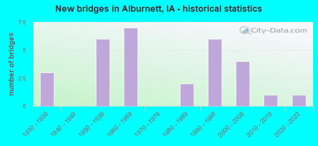
- New bridges - historical statistics
- 31930-1939
- 61950-1959
- 71960-1969
- 21980-1989
- 61990-1999
- 42000-2009
- 12010-2019
- 12020-2022

- Reconstructed bridges - Historical Statistics
- 21950-1959
- 01960-1969
- 11970-1979
- 01980-1989
- 01990-1999
- 02000-2009
- 12010-2019


- Bridge Condition - Deck
- 4.2%Excellent
- 37.5%Good
- 25.0%Satisfactory
- 33.3%Fair

- Bridge Condition - Superstructure
- 4.2%Excellent
- 62.5%Good
- 8.3%Satisfactory
- 25.0%Fair

- Bridge Condition - Substructure
- 4.2%Excellent
- 4.2%Very good
- 41.7%Good
- 25.0%Satisfactory
- 25.0%Fair

- Bridge Condition - Channel
- 25.0%Very good
- 25.0%Good
- 35.7%Satisfactory
- 14.3%Fair

- Bridge Condition - Culverts
- 16.7%Good
- 33.3%Satisfactory
- 33.3%Fair
- 16.7%Poor
Find on map >> Show street view
Structure Number: 1304, Location: 2.4 mi. W of Jct. IA 25 (Lat: 41.301911, Lng: -94.500425), Route carried "on" structure: State highway 92, Year Built: 1966, Status: Open, Structure Length: 5.82m (19.09ft), Average Daily Traffic: 2,530 (year 2020), Truck Traffic: 10%, Average Future Daily Traffic: 2,530 (year 2041), Design Load: HS 20, Features Intersected: MIDDLE NODAWAY RIVER
Minimum Vertical Clearance: 30+ m (98+ ft), Kilometerpoint: 125.040, Lanes on structure: 2, Base Highway Network: Yes, Owner: State Highway Agency, Approaching Roadway Width: 13.4m (44.0ft), Material/Design: Prestressed concrete, Design/Construction: Stringer/Multi-beam, Number Of Spans In Main Unit: 3, Length of Maximum Span: 19.8m (65.0ft), Curb-To-Curb Width: 9.1m (29.9ft), Out-to-Out Width: 11.0m (36.1ft)
Condition: Deck: Satisfactory, Superstructure: Fair, Substructure: Good, Channel: Good, Operating Rating: 72.3 metric tons, Method Used To Determine Operating Rating: Load Factor (LF), Inventory Rating: 30.2 metric tons, Method Used To Determine Inventory Rating: Load Factor (LF), Structural Evaluation: Somewhat better than minimum adequacy, Deck Geometry: Meets minimum limits, Waterway Adequacy: Equal to present desirable criteria, Approach Roadway Alignment: Better than present minimum criteria, Designated Inspection Frequency: Every 24 months, Inspection Date: May 2021, Deck Structure Type: Concrete Cast-file-Place, Wearing Surface/Protective System: Wearing Surface: Monolithic Concrete
Find on map >> Show street view
Structure Number: 1335, Location: 071321702 (Lat: 40.950603, Lng: -94.565828), Route carried "on" structure: County highway , Year Built: 1967, Status: Open, Structure Length: 0.73m (2.40ft), Average Daily Traffic: 1,410 (year 2016), Truck Traffic: 17%, Average Future Daily Traffic: 1,410 (year 2042), Design Load: HS 20, Features Intersected: SAYLINGS CREEK, Facility Carried by Structure: SYCAMORE AVENUE
Minimum Vertical Clearance: 30+ m (98+ ft), Kilometerpoint: 5.686, Lanes on structure: 2, Base Highway Network: Yes, Owner: County Highway Agency, Approaching Roadway Width: 14.6m (47.9ft), Skew: 2 degrees, Material/Design: Concrete continuous, Design/Construction: Culvert, Number Of Spans In Main Unit: 2, Length of Maximum Span: 3.7m (12.1ft)
Condition: Channel: Satisfactory, Culverts: Satisfactory, Operating Rating: 44.1 metric tons, Method Used To Determine Operating Rating: Assigned rating based on Load Factor Design (LFD) reported in metric tons, Inventory Rating: 32.7 metric tons, Method Used To Determine Inventory Rating: Assigned rating based on Load Factor Design (LFD) reported in metric tons, Structural Evaluation: Equal to present minimum criteria, Waterway Adequacy: Better than present minimum criteria, Approach Roadway Alignment: Equal to present desirable criteria, Designated Inspection Frequency: Every 48 months, Inspection Date: January 2022
Find on map >> Show street view
Structure Number: 1337, Location: 072341603 (Lat: 41.040244, Lng: -94.763978), Route carried "on" structure: County highway , Year Built: 1933, Year Reconstructed: 1959, Status: Open, Structure Length: 4.66m (15.29ft), Average Daily Traffic: 370 (year 2016), Truck Traffic: 15%, Average Future Daily Traffic: 370 (year 2042), Design Load: HS 20, Features Intersected: KEMP CREEK, Facility Carried by Structure: FM-183RD STREET
Minimum Vertical Clearance: 30+ m (98+ ft), Kilometerpoint: 4.503, Lanes on structure: 2, Owner: County Highway Agency, Approaching Roadway Width: 12.2m (40.0ft), Material/Design: Steel continuous, Design/Construction: Stringer/Multi-beam, Number Of Spans In Main Unit: 3, Length of Maximum Span: 17.7m (58.1ft), Curb or Sidewalk Widths: Left: 0.6m (2.0ft), Right: 0.6m (2.0ft), Curb-To-Curb Width: 9.1m (29.9ft), Out-to-Out Width: 11.0m (36.1ft)
Condition: Deck: Fair, Superstructure: Good, Substructure: Satisfactory, Channel: Satisfactory, Operating Rating: 62.7 metric tons, Method Used To Determine Operating Rating: Load Factor (LF), Inventory Rating: 37.6 metric tons, Method Used To Determine Inventory Rating: Load Factor (LF), Structural Evaluation: Equal to present minimum criteria, Deck Geometry: Equal to present minimum criteria, Waterway Adequacy: Better than present minimum criteria, Approach Roadway Alignment: Equal to present desirable criteria, Designated Inspection Frequency: Every 24 months, Inspection Date: January 2022, Bridge Improvement Cost: $252,000, Roadway Improvement Cost: $25,000, Deck Structure Type: Concrete Cast-file-Place, Wearing Surface/Protective System: Wearing Surface: Low Slump Concrete
Find on map >> Show street view
Structure Number: 1341, Location: 0.3 mi. N of jct. SR N-28 (Lat: 41.043928, Lng: -94.756986), Route carried "on" structure: State highway 148, Year Built: 1958, Status: Open, Structure Length: 0.64m (2.10ft), Average Daily Traffic: 690 (year 2020), Truck Traffic: 23%, Average Future Daily Traffic: 690 (year 2040), Design Load: H 20, Features Intersected: STREAM
Minimum Vertical Clearance: 30+ m (98+ ft), Kilometerpoint: 56.659, Lanes on structure: 2, Base Highway Network: Yes, Owner: State Highway Agency, Approaching Roadway Width: 10.4m (34.1ft), Material/Design: Concrete continuous, Design/Construction: Culvert, Number Of Spans In Main Unit: 2, Length of Maximum Span: 3.0m (9.8ft)
Condition: Channel: Fair, Culverts: Satisfactory, Operating Rating: 18.9 metric tons, Method Used To Determine Operating Rating: Load Factor (LF), Inventory Rating: 11.3 metric tons, Method Used To Determine Inventory Rating: Load Factor (LF), Structural Evaluation: High priority of corrective action, Waterway Adequacy: Equal to present minimum criteria, Approach Roadway Alignment: Equal to present desirable criteria, Designated Inspection Frequency: Every 24 months, Inspection Date: September 2020
Find on map >> Show street view
Structure Number: 1342, Location: 0.4 mi. N of SR N28 (Lat: 41.046214, Lng: -94.756978), Route carried "on" structure: State highway 148, Year Built: 1931, Year Reconstructed: 1959, Status: Open, Structure Length: 5.85m (19.19ft), Average Daily Traffic: 690 (year 2020), Truck Traffic: 23%, Average Future Daily Traffic: 690 (year 2040), Design Load: H 20, Features Intersected: BR E NODAWAY RIVER
Minimum Vertical Clearance: 30+ m (98+ ft), Kilometerpoint: 56.913, Lanes on structure: 2, Base Highway Network: Yes, Owner: State Highway Agency, Approaching Roadway Width: 12.2m (40.0ft), Skew: 4 degrees, Material/Design: Steel continuous, Design/Construction: Stringer/Multi-beam, Number Of Spans In Main Unit: 3, Length of Maximum Span: 25.0m (82.0ft), Curb-To-Curb Width: 9.2m (30.2ft), Out-to-Out Width: 11.0m (36.1ft)
Condition: Deck: Satisfactory, Superstructure: Good, Substructure: Fair, Channel: Satisfactory, Operating Rating: 47.0 metric tons, Method Used To Determine Operating Rating: Load Factor (LF), Inventory Rating: 28.2 metric tons, Method Used To Determine Inventory Rating: Load Factor (LF), Structural Evaluation: Somewhat better than minimum adequacy, Deck Geometry: Equal to present minimum criteria, Waterway Adequacy: Equal to present desirable criteria, Approach Roadway Alignment: Equal to present desirable criteria, Designated Inspection Frequency: Every 24 months, Inspection Date: May 2020, Deck Structure Type: Concrete Cast-file-Place, Wearing Surface/Protective System: Wearing Surface: Low Slump Concrete
Find on map >> Show street view
Structure Number: 1343, Location: 1.8 MI. S OF Jct. SR H-20 (Lat: 41.096439, Lng: -94.757183), Route carried "on" structure: State highway 148, Year Built: 1959, Status: Open, Structure Length: 8.72m (28.61ft), Average Daily Traffic: 690 (year 2020), Truck Traffic: 23%, Average Future Daily Traffic: 690 (year 2040), Design Load: HS 20, Features Intersected: MIDDLE NODAWAY RIVER
Minimum Vertical Clearance: 30+ m (98+ ft), Kilometerpoint: 62.489, Lanes on structure: 2, Base Highway Network: Yes, Owner: State Highway Agency, Approaching Roadway Width: 11.0m (36.1ft), Skew: 4 degrees, Material/Design: Steel continuous, Design/Construction: Stringer/Multi-beam, Number Of Spans In Main Unit: 3, Length of Maximum Span: 33.2m (108.9ft), Curb-To-Curb Width: 9.2m (30.2ft), Out-to-Out Width: 10.9m (35.8ft)
Condition: Deck: Fair, Superstructure: Good, Substructure: Satisfactory, Channel: Satisfactory, Operating Rating: 47.6 metric tons, Method Used To Determine Operating Rating: Load Factor (LF), Inventory Rating: 28.6 metric tons, Method Used To Determine Inventory Rating: Load Factor (LF), Structural Evaluation: Equal to present minimum criteria, Deck Geometry: Equal to present minimum criteria, Waterway Adequacy: Equal to present minimum criteria, Approach Roadway Alignment: Equal to present desirable criteria, Designated Inspection Frequency: Every 24 months, Inspection Date: May 2020, Deck Structure Type: Concrete Cast-file-Place, Wearing Surface/Protective System: Wearing Surface: Low Slump Concrete
Find on map >> Show street view
Structure Number: 1798, Location: 2.0 MI. W OF JCT. IA 173 (Lat: 41.498153, Lng: -95.098944), Route carried "on" structure: Interstate 80, Year Built: 1966, Status: Open, Structure Length: 3.51m (11.52ft), Average Daily Traffic: 9,900 (year 2020), Truck Traffic: 41%, Average Future Daily Traffic: 9,900 (year 2041), Design Load: HS 20, Features Intersected: 570TH ST
Minimum Vertical Clearance: 30+ m (98+ ft), Kilometerpoint: 84.357, Lanes on structure: 2, Lanes under structure: 2, Base Highway Network: Yes, Owner: State Highway Agency, Approaching Roadway Width: 12.2m (40.0ft), Material/Design: Concrete, Design/Construction: Slab, Number Of Spans In Main Unit: 3, Length of Maximum Span: 11.9m (39.0ft), Curb-To-Curb Width: 11.9m (39.0ft), Out-to-Out Width: 12.9m (42.3ft)
Condition: Deck: Fair, Superstructure: Fair, Substructure: Fair, Operating Rating: 50.1 metric tons, Method Used To Determine Operating Rating: Allowable Stress (AS), Inventory Rating: 24.5 metric tons, Method Used To Determine Inventory Rating: Allowable Stress (AS), Structural Evaluation: Somewhat better than minimum adequacy, Deck Geometry: Equal to present minimum criteria, Underclear: High priority of corrective action, Approach Roadway Alignment: Better than present minimum criteria, Designated Inspection Frequency: Every 24 months, Inspection Date: March 2021, Deck Structure Type: Concrete Cast-file-Place, Wearing Surface/Protective System: Wearing Surface: Low Slump Concrete
Find on map >> Show street view
Structure Number: 1847, Location: 079030701 (Lat: 41.670331, Lng: -91.230161), Route carried "on" structure: County highway , Year Built: 1951, Status: Open, Structure Length: 0.64m (2.10ft), Average Daily Traffic: 820 (year 2018), Truck Traffic: 12%, Average Future Daily Traffic: 820 (year 2041), Design Load: H 20, Features Intersected: SMALL STREAM, Facility Carried by Structure: F44 290TH ST
Minimum Vertical Clearance: 30+ m (98+ ft), Kilometerpoint: 8.628, Lanes on structure: 2, Owner: County Highway Agency, Approaching Roadway Width: 13.4m (44.0ft), Material/Design: Concrete continuous, Design/Construction: Culvert, Number Of Spans In Main Unit: 2, Length of Maximum Span: 3.0m (9.8ft), Out-to-Out Width: 13.4m (44.0ft)
Condition: Channel: Satisfactory, Culverts: Fair, Operating Rating: 55.2 metric tons, Method Used To Determine Operating Rating: Load Factor (LF), Inventory Rating: 33.1 metric tons, Method Used To Determine Inventory Rating: Load Factor (LF), Structural Evaluation: Somewhat better than minimum adequacy, Waterway Adequacy: Better than present minimum criteria, Approach Roadway Alignment: Better than present minimum criteria, Length Of Structure Improvement: 10.00m (32.81ft), Designated Inspection Frequency: Every 24 months, Inspection Date: May 2021, Bridge Improvement Cost: $285,000, Roadway Improvement Cost: $29,000
Find on map >> Show street view
Structure Number: 25841, Location: 1.5 MI. S OF S JCT SR D35 (Lat: 42.369244, Lng: -92.768275), Route carried "on" structure: State highway 14, Year Built: 1931, Year Reconstructed: 1983, Status: Open, Structure Length: 5.46m (17.91ft), Average Daily Traffic: 3,310 (year 2020), Truck Traffic: 15%, Average Future Daily Traffic: 3,310 (year 2040), Design Load: HS 20, Features Intersected: BLACK HAWK CREEK
Minimum Vertical Clearance: 30+ m (98+ ft), Kilometerpoint: 211.032, Lanes on structure: 2, Base Highway Network: Yes, Owner: State Highway Agency, Approaching Roadway Width: 12.2m (40.0ft), Material/Design: Steel continuous, Design/Construction: Girder and Floorbeam System, Number Of Spans In Main Unit: 2, Number Of Approach Spans: 2, Length of Maximum Span: 14.0m (45.9ft), Curb-To-Curb Width: 9.1m (29.9ft), Out-to-Out Width: 10.1m (33.1ft)
Condition: Deck: Fair, Superstructure: Good, Substructure: Satisfactory, Channel: Good, Operating Rating: 35.4 metric tons, Method Used To Determine Operating Rating: Allowable Stress (AS), Inventory Rating: 17.2 metric tons, Method Used To Determine Inventory Rating: Allowable Stress (AS), Structural Evaluation: Meets minimum limits, Deck Geometry: Meets minimum limits, Waterway Adequacy: Equal to present desirable criteria, Approach Roadway Alignment: Equal to present desirable criteria, Designated Inspection Frequency: Every 24 months, Critical Feature Inspection Frequency: Every 24 months, Inspection Date: August 2020, Critical Feature Inspection Date: August 2020, Deck Structure Type: Concrete Cast-file-Place, Wearing Surface/Protective System: Wearing Surface: Monolithic Concrete, Deck Protection: Epoxy Coated Reinforcing
Find on map >> Show street view
Structure Number: 776, Location: 084250101 (Lat: 42.123083, Lng: -93.715314), Route carried "on" structure: County highway , Year Built: 1952, Year Reconstructed: 2017, Status: Posted for load, Structure Length: 3.84m (12.60ft), Average Daily Traffic: 100 (year 2019), Average Future Daily Traffic: 100 (year 2040), Design Load: H 15, Features Intersected: IOWAY CREEK, Facility Carried by Structure: LOCAL
Minimum Vertical Clearance: 30+ m (98+ ft), Kilometerpoint: 23.768, Lanes on structure: 2, Owner: County Highway Agency, Approaching Roadway Width: 7.6m (24.9ft), Material/Design: Concrete continuous, Design/Construction: Slab, Number Of Spans In Main Unit: 3, Length of Maximum Span: 15.2m (49.9ft), Curb-To-Curb Width: 6.1m (20.0ft), Out-to-Out Width: 7.3m (24.0ft)
Condition: Deck: Fair, Superstructure: Fair, Substructure: Fair, Channel: Fair, Operating Rating: 31.7 metric tons, Method Used To Determine Operating Rating: Load Factor (LF), Inventory Rating: 19.0 metric tons, Method Used To Determine Inventory Rating: Load Factor (LF), Structural Evaluation: Somewhat better than minimum adequacy, Deck Geometry: Somewhat better than minimum adequacy, Waterway Adequacy: Better than present minimum criteria, Approach Roadway Alignment: Better than present minimum criteria, Bridge Posting: Required (Relationship of Operating Rating to Maximum Legal Load: 10.0 - 19.9% below), Length Of Structure Improvement: 12.60m (41.34ft), Designated Inspection Frequency: Every 24 months, Inspection Date: May 2020, Bridge Improvement Cost: $334,000, Roadway Improvement Cost: $33,000, Deck Structure Type: Concrete Cast-file-Place, Wearing Surface/Protective System: Wearing Surface: Monolithic Concrete
Find on map >> Show street view
Structure Number: 102531, Location: 080011802 (Lat: 41.733819, Lng: -91.015739), Route carried "on" structure: County highway , Year Built: 1999, Status: Open, Structure Length: 0.88m (2.89ft), Average Daily Traffic: 20 (year 2018), Average Future Daily Traffic: 20 (year 2040), Features Intersected: SMALL, Facility Carried by Structure: SPICER AVE
Minimum Vertical Clearance: 30+ m (98+ ft), Kilometerpoint: 13.115, Lanes on structure: 2, Owner: County Highway Agency, Approaching Roadway Width: 6.1m (20.0ft), Material/Design: Steel, Design/Construction: Stringer/Multi-beam, Number Of Spans In Main Unit: 1, Length of Maximum Span: 8.5m (27.9ft), Curb-To-Curb Width: 7.2m (23.6ft), Out-to-Out Width: 9.2m (30.2ft)
Condition: Deck: Satisfactory, Superstructure: Good, Substructure: Good, Channel: Good, Operating Rating: 34.9 metric tons, Method Used To Determine Operating Rating: Allowable Stress (AS), Inventory Rating: 23.2 metric tons, Method Used To Determine Inventory Rating: Load Factor (LF), Structural Evaluation: Equal to present minimum criteria, Deck Geometry: Somewhat better than minimum adequacy, Waterway Adequacy: Better than present minimum criteria, Approach Roadway Alignment: Better than present minimum criteria, Length Of Structure Improvement: 3.00m (9.84ft), Designated Inspection Frequency: Every 24 months, Inspection Date: June 2020, Bridge Improvement Cost: $15,000, Roadway Improvement Cost: $2,000, Deck Structure Type: Wood or Timber, Wearing Surface/Protective System: Wearing Surface: Gravel
Find on map >> Show street view
Structure Number: 103451, Location: 081011606 (Lat: 41.821253, Lng: -90.965717), Route carried "on" structure: County highway , Year Built: 2011, Status: Open, Structure Length: 0.64m (2.10ft), Average Daily Traffic: 480 (year 2018), Truck Traffic: 11%, Average Future Daily Traffic: 480 (year 2040), Design Load: HS 20, Features Intersected: LIZARD CREEK, Facility Carried by Structure: HOOVER HWY
Minimum Vertical Clearance: 30+ m (98+ ft), Kilometerpoint: 6.169, Lanes on structure: 2, Owner: County Highway Agency, Approaching Roadway Width: 11.0m (36.1ft), Material/Design: Concrete continuous, Design/Construction: Culvert, Number Of Spans In Main Unit: 2, Length of Maximum Span: 3.0m (9.8ft)
Condition: Channel: Good, Culverts: Good, Operating Rating: 44.1 metric tons, Method Used To Determine Operating Rating: Assigned rating based on Load Factor Design (LFD) reported in metric tons, Inventory Rating: 32.7 metric tons, Method Used To Determine Inventory Rating: Assigned rating based on Load Factor Design (LFD) reported in metric tons, Structural Evaluation: Better than present minimum criteria, Waterway Adequacy: Equal to present desirable criteria, Approach Roadway Alignment: Better than present minimum criteria, Designated Inspection Frequency: Every 48 months, Inspection Date: May 2020
Find on map >> Show street view
Structure Number: 107351, Location: 090402701 (Lat: 42.590725, Lng: -95.553786), Route carried "on" structure: County highway , Year Built: 1982, Status: Open, Structure Length: 2.10m (6.89ft), Average Daily Traffic: 25 (year 2019), Average Future Daily Traffic: 25 (year 2041), Design Load: HS 20, Features Intersected: SILVER CREEK, Facility Carried by Structure: LOCAL- 640TH ST
Minimum Vertical Clearance: 30+ m (98+ ft), Kilometerpoint: 18.794, Lanes on structure: 2, Owner: County Highway Agency, Approaching Roadway Width: 7.9m (25.9ft), Material/Design: Prestressed concrete, Design/Construction: Stringer/Multi-beam, Number Of Spans In Main Unit: 1, Length of Maximum Span: 20.7m (67.9ft), Curb-To-Curb Width: 8.5m (27.9ft), Out-to-Out Width: 9.1m (29.9ft)
Condition: Deck: Satisfactory, Superstructure: Good, Substructure: Satisfactory, Channel: Satisfactory, Operating Rating: 56.8 metric tons, Method Used To Determine Operating Rating: Allowable Stress (AS), Inventory Rating: 23.9 metric tons, Method Used To Determine Inventory Rating: Allowable Stress (AS), Structural Evaluation: Equal to present minimum criteria, Waterway Adequacy: Better than present minimum criteria, Approach Roadway Alignment: Equal to present desirable criteria, Length Of Structure Improvement: 6.90m (22.64ft), Designated Inspection Frequency: Every 24 months, Inspection Date: August 2021, Bridge Improvement Cost: $15,000, Roadway Improvement Cost: $2,000, Deck Structure Type: Concrete Cast-file-Place, Wearing Surface/Protective System: Wearing Surface: Monolithic Concrete
Find on map >> Show street view
Structure Number: 221501, Location: 084070203 (Lat: 42.116419, Lng: -91.619278), Route carried "on" structure: County highway , Year Built: 1989, Status: Open, Structure Length: 1.43m (4.69ft), Average Daily Traffic: 20 (year 2017), Average Future Daily Traffic: 20 (year 2040), Design Load: HS 20, Features Intersected: DRY CR, Facility Carried by Structure: WHITE RD
Minimum Vertical Clearance: 30+ m (98+ ft), Kilometerpoint: 1.592, Lanes on structure: 2, Owner: County Highway Agency, Approaching Roadway Width: 8.2m (26.9ft), Material/Design: Wood or Timber, Design/Construction: Slab, Number Of Spans In Main Unit: 2, Length of Maximum Span: 7.3m (24.0ft), Curb-To-Curb Width: 8.0m (26.2ft), Out-to-Out Width: 8.0m (26.2ft)
Condition: Deck: Good, Superstructure: Good, Substructure: Good, Channel: Good, Operating Rating: 78.3 metric tons, Method Used To Determine Operating Rating: Allowable Stress (AS), Inventory Rating: 57.9 metric tons, Method Used To Determine Inventory Rating: Allowable Stress (AS), Structural Evaluation: Better than present minimum criteria, Deck Geometry: Equal to present minimum criteria, Waterway Adequacy: Equal to present desirable criteria, Approach Roadway Alignment: Equal to present desirable criteria, Designated Inspection Frequency: Every 24 months, Inspection Date: July 2020, Deck Structure Type: Wood or Timber, Wearing Surface/Protective System: Wearing Surface: Bituminous
Find on map >> Show street view
Structure Number: 222181, Location: 085061904 (Lat: 42.157231, Lng: -91.580431), Route carried "on" structure: County highway , Year Built: 2002, Status: Open, Structure Length: 1.46m (4.79ft), Average Daily Traffic: 80 (year 2017), Average Future Daily Traffic: 80 (year 2040), Design Load: HS 20, Features Intersected: INDIAN CREEK, Facility Carried by Structure: SUTTON RD
Minimum Vertical Clearance: 30+ m (98+ ft), Kilometerpoint: 3.862, Lanes on structure: 2, Owner: County Highway Agency, Approaching Roadway Width: 7.9m (25.9ft), Material/Design: Wood or Timber, Design/Construction: Slab, Number Of Spans In Main Unit: 2, Length of Maximum Span: 7.3m (24.0ft), Curb-To-Curb Width: 7.3m (24.0ft), Out-to-Out Width: 7.5m (24.6ft)
Condition: Deck: Good, Superstructure: Good, Substructure: Very good, Channel: Very good, Operating Rating: 78.3 metric tons, Method Used To Determine Operating Rating: Allowable Stress (AS), Inventory Rating: 57.9 metric tons, Method Used To Determine Inventory Rating: Allowable Stress (AS), Structural Evaluation: Better than present minimum criteria, Deck Geometry: Equal to present minimum criteria, Waterway Adequacy: Superior to present desirable criteria, Approach Roadway Alignment: Meets minimum limits, Designated Inspection Frequency: Every 24 months, Inspection Date: June 2020, Deck Structure Type: Aluminum, Wearing Surface/Protective System: Wearing Surface: Bituminous
Find on map >> Show street view
Structure Number: 22221, Location: 085062901 (Lat: 42.152672, Lng: -91.578417), Route carried "on" structure: County highway , Year Built: 1959, Status: Open, Structure Length: 0.82m (2.69ft), Average Daily Traffic: 490 (year 2017), Truck Traffic: 11%, Average Future Daily Traffic: 490 (year 2040), Design Load: H 20, Features Intersected: INDAIN CREEK, Facility Carried by Structure: BURNETT STA.RD.
Minimum Vertical Clearance: 30+ m (98+ ft), Kilometerpoint: 2.902, Lanes on structure: 2, Owner: County Highway Agency, Approaching Roadway Width: 9.8m (32.2ft), Material/Design: Concrete continuous, Design/Construction: Culvert, Number Of Spans In Main Unit: 2, Length of Maximum Span: 3.7m (12.1ft), Curb-To-Curb Width: 9.8m (32.2ft), Out-to-Out Width: 9.8m (32.2ft)
Condition: Channel: Fair, Culverts: Poor, Operating Rating: 55.4 metric tons, Method Used To Determine Operating Rating: Load and Resistance Factor Rating (LRFR) rating reported by rating factor(RF) method using HL-93 loadings, Inventory Rating: 42.8 metric tons, Method Used To Determine Inventory Rating: Load and Resistance Factor Rating (LRFR) rating reported by rating factor(RF) method using HL-93 loadings, Structural Evaluation: Meets minimum limits, Deck Geometry: Equal to present minimum criteria, Waterway Adequacy: Better than present minimum criteria, Approach Roadway Alignment: Better than present minimum criteria, Designated Inspection Frequency: Every 24 months, Inspection Date: June 2020
Find on map >> Show street view
Structure Number: 222221, Location: 085063201 (Lat: 42.138019, Lng: -91.575092), Route carried "on" structure: County highway , Year Built: 1997, Status: Open, Structure Length: 1.49m (4.89ft), Average Daily Traffic: 35 (year 2017), Average Future Daily Traffic: 35 (year 2040), Design Load: HS 20, Features Intersected: INDAIN CREEK, Facility Carried by Structure: INDIAN BR.RD.
Minimum Vertical Clearance: 30+ m (98+ ft), Kilometerpoint: 0.357, Lanes on structure: 2, Owner: County Highway Agency, Approaching Roadway Width: 6.1m (20.0ft), Material/Design: Wood or Timber, Design/Construction: Slab, Number Of Spans In Main Unit: 2, Length of Maximum Span: 7.3m (24.0ft), Curb-To-Curb Width: 7.1m (23.3ft), Out-to-Out Width: 7.3m (24.0ft)
Condition: Deck: Fair, Superstructure: Fair, Substructure: Fair, Channel: Good, Operating Rating: 67.4 metric tons, Method Used To Determine Operating Rating: Allowable Stress (AS), Inventory Rating: 49.9 metric tons, Method Used To Determine Inventory Rating: Allowable Stress (AS), Structural Evaluation: Somewhat better than minimum adequacy, Waterway Adequacy: Equal to present desirable criteria, Approach Roadway Alignment: Equal to present desirable criteria, Designated Inspection Frequency: Every 24 months, Inspection Date: July 2020, Deck Structure Type: Wood or Timber, Wearing Surface/Protective System: Wearing Surface: Bituminous
Find on map >> Show street view
Structure Number: 222261, Location: 085070303 (Lat: 42.209686, Lng: -91.640222), Route carried "on" structure: County highway , Year Built: 2005, Status: Open, Structure Length: 1.46m (4.79ft), Average Daily Traffic: 30 (year 2017), Average Future Daily Traffic: 30 (year 2040), Design Load: HS 20, Features Intersected: E OTTER CR, Facility Carried by Structure: LYMAN RD.
Minimum Vertical Clearance: 30+ m (98+ ft), Kilometerpoint: 2.955, Lanes on structure: 2, Owner: County Highway Agency, Approaching Roadway Width: 9.8m (32.2ft), Material/Design: Wood or Timber, Design/Construction: Slab, Number Of Spans In Main Unit: 2, Length of Maximum Span: 7.0m (23.0ft), Curb-To-Curb Width: 7.3m (24.0ft), Out-to-Out Width: 7.9m (25.9ft)
Condition: Deck: Good, Superstructure: Good, Substructure: Good, Channel: Very good, Operating Rating: 78.3 metric tons, Method Used To Determine Operating Rating: Allowable Stress (AS), Inventory Rating: 57.9 metric tons, Method Used To Determine Inventory Rating: Allowable Stress (AS), Structural Evaluation: Better than present minimum criteria, Deck Geometry: Equal to present minimum criteria, Waterway Adequacy: Equal to present desirable criteria, Approach Roadway Alignment: Equal to present desirable criteria, Designated Inspection Frequency: Every 24 months, Inspection Date: July 2020, Deck Structure Type: Concrete Cast-file-Place, Wearing Surface/Protective System: Wearing Surface: Monolithic Concrete
Find on map >> Show street view
Structure Number: 22232, Location: 085071006 (Lat: 42.184136, Lng: -91.642192), Route carried "on" structure: County highway , Year Built: 1995, Status: Open, Structure Length: 1.40m (4.59ft), Average Daily Traffic: 70 (year 2017), Average Future Daily Traffic: 70 (year 2040), Design Load: HS 20, Features Intersected: EAST OTTER CREEK, Facility Carried by Structure: FLEMINGVIL RD
Minimum Vertical Clearance: 30+ m (98+ ft), Kilometerpoint: 1.822, Lanes on structure: 2, Owner: County Highway Agency, Approaching Roadway Width: 8.2m (26.9ft), Skew: 3 degrees, Material/Design: Wood or Timber, Design/Construction: Slab, Number Of Spans In Main Unit: 2, Length of Maximum Span: 6.7m (22.0ft), Curb-To-Curb Width: 7.4m (24.3ft), Out-to-Out Width: 7.6m (24.9ft)
Condition: Deck: Good, Superstructure: Good, Substructure: Good, Channel: Very good, Structural Evaluation: Better than present minimum criteria, Deck Geometry: Equal to present minimum criteria, Waterway Adequacy: Equal to present desirable criteria, Approach Roadway Alignment: Equal to present desirable criteria, Designated Inspection Frequency: Every 24 months, Inspection Date: July 2020, Deck Structure Type: Wood or Timber, Wearing Surface/Protective System: Wearing Surface: Bituminous
Find on map >> Show street view
Structure Number: 22233, Location: 085071101 (Lat: 42.196872, Lng: -91.634525), Route carried "on" structure: County highway , Year Built: 1962, Status: Open, Structure Length: 0.98m (3.22ft), Average Daily Traffic: 2,200 (year 2021), Truck Traffic: 11%, Average Future Daily Traffic: 2,200 (year 2040), Design Load: H 20, Features Intersected: EAST OTTER CREEK, Facility Carried by Structure: CENTRAL CITY RD
Minimum Vertical Clearance: 30+ m (98+ ft), Kilometerpoint: 11.552, Lanes on structure: 2, Owner: County Highway Agency, Approaching Roadway Width: 11.3m (37.1ft), Material/Design: Concrete, Design/Construction: Slab, Number Of Spans In Main Unit: 1, Length of Maximum Span: 9.1m (29.9ft), Curb-To-Curb Width: 8.5m (27.9ft), Out-to-Out Width: 9.8m (32.2ft)
Condition: Deck: Satisfactory, Superstructure: Satisfactory, Substructure: Satisfactory, Channel: Satisfactory, Operating Rating: 34.3 metric tons, Method Used To Determine Operating Rating: Load and Resistance Factor Rating (LRFR) rating reported by rating factor(RF) method using HL-93 loadings, Inventory Rating: 26.6 metric tons, Method Used To Determine Inventory Rating: Load and Resistance Factor Rating (LRFR) rating reported by rating factor(RF) method using HL-93 loadings, Structural Evaluation: Equal to present minimum criteria, Deck Geometry: Meets minimum limits, Waterway Adequacy: Better than present minimum criteria, Approach Roadway Alignment: Better than present minimum criteria, Length Of Structure Improvement: 3.50m (11.48ft), Designated Inspection Frequency: Every 24 months, Inspection Date: July 2020, Bridge Improvement Cost: $40,000, Roadway Improvement Cost: $20,000, Deck Structure Type: Concrete Cast-file-Place, Wearing Surface/Protective System: Wearing Surface: Monolithic Concrete
Find on map >> Show street view
Structure Number: 222351, Location: 085071504 (Lat: 42.176006, Lng: -91.657064), Route carried "on" structure: County highway , Year Built: 1999, Status: Open, Structure Length: 1.46m (4.79ft), Average Daily Traffic: 70 (year 2017), Average Future Daily Traffic: 70 (year 2040), Design Load: HS 20, Features Intersected: EAST OTTER CREEK, Facility Carried by Structure: CUPOLA RD
Minimum Vertical Clearance: 30+ m (98+ ft), Kilometerpoint: 0.909, Lanes on structure: 2, Owner: County Highway Agency, Approaching Roadway Width: 9.8m (32.2ft), Material/Design: Wood or Timber, Design/Construction: Slab, Number Of Spans In Main Unit: 2, Length of Maximum Span: 7.3m (24.0ft), Curb-To-Curb Width: 7.3m (24.0ft), Out-to-Out Width: 7.3m (24.0ft)
Condition: Deck: Good, Superstructure: Good, Substructure: Good, Channel: Very good, Operating Rating: 78.3 metric tons, Method Used To Determine Operating Rating: Allowable Stress (AS), Inventory Rating: 57.9 metric tons, Method Used To Determine Inventory Rating: Allowable Stress (AS), Structural Evaluation: Better than present minimum criteria, Deck Geometry: Equal to present minimum criteria, Waterway Adequacy: Equal to present desirable criteria, Approach Roadway Alignment: Equal to present desirable criteria, Designated Inspection Frequency: Every 24 months, Inspection Date: July 2020, Deck Structure Type: Wood or Timber, Wearing Surface/Protective System: Wearing Surface: Bituminous
Find on map >> Show street view
Structure Number: 222391, Location: 085072103 (Lat: 42.167864, Lng: -91.663450), Route carried "on" structure: County highway , Year Built: 2000, Status: Open, Structure Length: 2.19m (7.19ft), Average Daily Traffic: 100 (year 2017), Average Future Daily Traffic: 100 (year 2040), Design Load: HS 20, Features Intersected: E OTTER CREEK, Facility Carried by Structure: OLD CENTER RD
Minimum Vertical Clearance: 30+ m (98+ ft), Kilometerpoint: 3.114, Lanes on structure: 2, Owner: County Highway Agency, Approaching Roadway Width: 8.2m (26.9ft), Material/Design: Wood or Timber, Design/Construction: Slab, Number Of Spans In Main Unit: 3, Length of Maximum Span: 7.3m (24.0ft), Curb-To-Curb Width: 7.3m (24.0ft), Out-to-Out Width: 7.5m (24.6ft)
Condition: Deck: Good, Superstructure: Good, Substructure: Good, Channel: Very good, Operating Rating: 78.3 metric tons, Method Used To Determine Operating Rating: Allowable Stress (AS), Inventory Rating: 57.9 metric tons, Method Used To Determine Inventory Rating: Allowable Stress (AS), Structural Evaluation: Better than present minimum criteria, Deck Geometry: Equal to present minimum criteria, Waterway Adequacy: Equal to present desirable criteria, Approach Roadway Alignment: Equal to present desirable criteria, Designated Inspection Frequency: Every 24 months, Inspection Date: July 2020, Deck Structure Type: Wood or Timber, Wearing Surface/Protective System: Wearing Surface: Bituminous
Find on map >> Show street view
Structure Number: 2224, Location: 000000000 (Lat: 42.153089, Lng: -91.613936), Route carried "on" structure: City street , Year Built: 1959, Status: Open, Structure Length: 1.46m (4.79ft), Average Daily Traffic: 530 (year 2021), Average Future Daily Traffic: 530 (year 2041), Design Load: HL 93, Features Intersected: DRY CREEK, Facility Carried by Structure: NORTH ST
Minimum Vertical Clearance: 30+ m (98+ ft), Kilometerpoint: 0.438, Lanes on structure: 2, Owner: City or Municipal Highway Agency, Approaching Roadway Width: 9.8m (32.2ft), Material/Design: Concrete continuous, Design/Construction: Culvert, Number Of Spans In Main Unit: 3, Length of Maximum Span: 4.6m (15.1ft)
Condition: Channel: Fair, Culverts: Fair, Operating Rating: 44.7 metric tons, Method Used To Determine Operating Rating: Load and Resistance Factor Rating (LRFR) rating reported by rating factor(RF) method using HL-93 loadings, Inventory Rating: 34.3 metric tons, Method Used To Determine Inventory Rating: Load and Resistance Factor Rating (LRFR) rating reported by rating factor(RF) method using HL-93 loadings, Structural Evaluation: Somewhat better than minimum adequacy, Waterway Adequacy: Better than present minimum criteria, Approach Roadway Alignment: Equal to present minimum criteria, Designated Inspection Frequency: Every 24 months, Inspection Date: March 2021
Find on map >> Show street view
Structure Number: 222461, Location: 085073603 (Lat: 42.134878, Lng: -91.615833), Route carried "on" structure: County highway , Year Built: 1991, Status: Open, Structure Length: 1.46m (4.79ft), Average Daily Traffic: 50 (year 2017), Average Future Daily Traffic: 50 (year 2040), Design Load: HS 20, Features Intersected: DRY CREEK, Facility Carried by Structure: ARABIAN RD
Minimum Vertical Clearance: 30+ m (98+ ft), Kilometerpoint: 4.712, Lanes on structure: 2, Owner: County Highway Agency, Approaching Roadway Width: 7.3m (24.0ft), Material/Design: Wood or Timber, Design/Construction: Slab, Number Of Spans In Main Unit: 2, Length of Maximum Span: 7.3m (24.0ft), Curb-To-Curb Width: 7.3m (24.0ft), Out-to-Out Width: 7.3m (24.0ft)
Condition: Deck: Good, Superstructure: Good, Substructure: Good, Channel: Good, Operating Rating: 78.3 metric tons, Method Used To Determine Operating Rating: Allowable Stress (AS), Inventory Rating: 57.9 metric tons, Method Used To Determine Inventory Rating: Allowable Stress (AS), Structural Evaluation: Better than present minimum criteria, Deck Geometry: Equal to present minimum criteria, Waterway Adequacy: Equal to present desirable criteria, Approach Roadway Alignment: Equal to present desirable criteria, Designated Inspection Frequency: Every 24 months, Inspection Date: July 2020, Deck Structure Type: Wood or Timber, Wearing Surface/Protective System: Wearing Surface: Bituminous
Find on map >> Show street view
Structure Number: 222471, Location: 085073608 (Lat: 42.124961, Lng: -91.618947), Route carried "on" structure: County highway , Year Built: 1996, Status: Open, Structure Length: 3.93m (12.89ft), Average Daily Traffic: 1,930 (year 2021), Truck Traffic: 11%, Average Future Daily Traffic: 1,930 (year 2040), Design Load: HS 20, Features Intersected: DRY CREEK, Facility Carried by Structure: ALBURNETT RD
Minimum Vertical Clearance: 30+ m (98+ ft), Kilometerpoint: 3.376, Lanes on structure: 2, Owner: County Highway Agency, Approaching Roadway Width: 12.2m (40.0ft), Skew: 3 degrees, Material/Design: Concrete continuous, Design/Construction: Slab, Number Of Spans In Main Unit: 3, Length of Maximum Span: 14.9m (48.9ft), Curb-To-Curb Width: 12.2m (40.0ft), Out-to-Out Width: 13.2m (43.3ft)
Condition: Deck: Good, Superstructure: Good, Substructure: Good, Channel: Very good, Operating Rating: 75.5 metric tons, Method Used To Determine Operating Rating: Load and Resistance Factor Rating (LRFR) rating reported by rating factor(RF) method using HL-93 loadings, Inventory Rating: 58.3 metric tons, Method Used To Determine Inventory Rating: Load and Resistance Factor Rating (LRFR) rating reported by rating factor(RF) method using HL-93 loadings, Structural Evaluation: Better than present minimum criteria, Deck Geometry: Better than present minimum criteria, Waterway Adequacy: Equal to present desirable criteria, Approach Roadway Alignment: Equal to present desirable criteria, Designated Inspection Frequency: Every 24 months, Inspection Date: July 2020, Deck Structure Type: Concrete Cast-file-Place, Wearing Surface/Protective System: Wearing Surface: Monolithic Concrete, Deck Protection: Epoxy Coated Reinforcing
Find on map >> Show street view
Structure Number: 23998, Location: 075200402 (Lat: 41.331633, Lng: -93.176833), Route carried "on" structure: County highway , Year Built: 1968, Status: Open, Structure Length: 8.11m (26.61ft), Average Daily Traffic: 260 (year 2018), Truck Traffic: 7%, Average Future Daily Traffic: 260 (year 2041), Design Load: H 15, Features Intersected: BUTCHER CREEK, Facility Carried by Structure: FM
Minimum Vertical Clearance: 30+ m (98+ ft), Kilometerpoint: 6.441, Lanes on structure: 2, Owner: County Highway Agency, Approaching Roadway Width: 10.4m (34.1ft), Material/Design: Steel continuous, Design/Construction: Stringer/Multi-beam, Number Of Spans In Main Unit: 3, Length of Maximum Span: 31.4m (103.0ft), Curb-To-Curb Width: 7.9m (25.9ft), Out-to-Out Width: 8.5m (27.9ft)
Condition: Deck: Satisfactory, Superstructure: Satisfactory, Substructure: Satisfactory, Channel: Very good, Operating Rating: 43.0 metric tons, Method Used To Determine Operating Rating: Load Factor (LF), Inventory Rating: 25.8 metric tons, Method Used To Determine Inventory Rating: Load Factor (LF), Structural Evaluation: Equal to present minimum criteria, Deck Geometry: Somewhat better than minimum adequacy, Waterway Adequacy: Equal to present desirable criteria, Approach Roadway Alignment: Better than present minimum criteria, Length Of Structure Improvement: 30.00m (98.43ft), Designated Inspection Frequency: Every 24 months, Inspection Date: December 2021, Bridge Improvement Cost: $300,000, Roadway Improvement Cost: $50,000, Deck Structure Type: Concrete Cast-file-Place, Wearing Surface/Protective System: Wearing Surface: Monolithic Concrete
Find on map >> Show street view
Structure Number: 25842, Location: 078042002 (Lat: 41.541392, Lng: -91.347967), Route carried "on" structure: County highway , Year Built: 1967, Status: Open, Structure Length: 1.04m (3.41ft), Average Daily Traffic: 50 (year 2018), Average Future Daily Traffic: 50 (year 2041), Design Load: H 20, Features Intersected: WAPSIE CREEK, Facility Carried by Structure: FM
Minimum Vertical Clearance: 30+ m (98+ ft), Kilometerpoint: 9.720, Lanes on structure: 2, Owner: County Highway Agency, Approaching Roadway Width: 9.8m (32.2ft), Skew: 3 degrees, Material/Design: Concrete, Design/Construction: Slab, Number Of Spans In Main Unit: 1, Length of Maximum Span: 9.1m (29.9ft), Curb-To-Curb Width: 8.5m (27.9ft), Out-to-Out Width: 9.1m (29.9ft)
Condition: Deck: Fair, Superstructure: Fair, Substructure: Fair, Channel: Satisfactory, Operating Rating: 55.3 metric tons, Method Used To Determine Operating Rating: Allowable Stress (AS), Inventory Rating: 30.8 metric tons, Method Used To Determine Inventory Rating: Allowable Stress (AS), Structural Evaluation: Somewhat better than minimum adequacy, Deck Geometry: Better than present minimum criteria, Waterway Adequacy: Better than present minimum criteria, Approach Roadway Alignment: Better than present minimum criteria, Length Of Structure Improvement: 5.00m (16.40ft), Designated Inspection Frequency: Every 24 months, Inspection Date: September 2021, Bridge Improvement Cost: $120,000, Roadway Improvement Cost: $12,000, Deck Structure Type: Concrete Cast-file-Place, Wearing Surface/Protective System: Wearing Surface: Monolithic Concrete
Find on map >> Show street view
Structure Number: 30238, Location: 079E11104 (Lat: 41.666014, Lng: -90.807011), Route carried "on" structure: County highway , Year Built: 1965, Status: Open, Structure Length: 3.93m (12.89ft), Average Daily Traffic: 30 (year 2018), Average Future Daily Traffic: 30 (year 2041), Design Load: H 15, Features Intersected: MUD CREEK, Facility Carried by Structure: 47TH AVE
Minimum Vertical Clearance: 30+ m (98+ ft), Kilometerpoint: 1.252, Lanes on structure: 2, Owner: County Highway Agency, Approaching Roadway Width: 7.0m (23.0ft), Skew: 2 degrees, Material/Design: Concrete continuous, Design/Construction: Slab, Number Of Spans In Main Unit: 3, Length of Maximum Span: 14.9m (48.9ft), Curb-To-Curb Width: 7.3m (24.0ft), Out-to-Out Width: 7.6m (24.9ft)
Condition: Deck: Fair, Superstructure: Fair, Substructure: Fair, Channel: Satisfactory, Operating Rating: 37.2 metric tons, Method Used To Determine Operating Rating: Load Factor (LF), Inventory Rating: 22.3 metric tons, Method Used To Determine Inventory Rating: Load Factor (LF), Structural Evaluation: Somewhat better than minimum adequacy, Deck Geometry: Equal to present minimum criteria, Waterway Adequacy: Better than present minimum criteria, Approach Roadway Alignment: Better than present minimum criteria, Length Of Structure Improvement: 16.30m (53.48ft), Designated Inspection Frequency: Every 24 months, Inspection Date: April 2021, Bridge Improvement Cost: $370,000, Roadway Improvement Cost: $37,000, Deck Structure Type: Concrete Cast-file-Place, Wearing Surface/Protective System: Wearing Surface: Monolithic Concrete
Find on map >> Show street view
Structure Number: 36445, Location: 085060702 (Lat: 42.182283, Lng: -91.598033), Route carried "on" structure: County highway , Year Built: 2001, Status: Open, Structure Length: 0.73m (2.40ft), Average Daily Traffic: 45 (year 2021), Truck Traffic: 16%, Average Future Daily Traffic: 45 (year 2040), Design Load: HS 20, Features Intersected: DRY CREEK, Facility Carried by Structure: NORTH MARION RD
Minimum Vertical Clearance: 30+ m (98+ ft), Kilometerpoint: 9.728, Lanes on structure: 2, Owner: County Highway Agency, Approaching Roadway Width: 7.9m (25.9ft), Material/Design: Wood or Timber, Design/Construction: Slab, Number Of Spans In Main Unit: 1, Length of Maximum Span: 7.0m (23.0ft), Curb-To-Curb Width: 7.3m (24.0ft), Out-to-Out Width: 7.5m (24.6ft)
Condition: Deck: Good, Superstructure: Good, Substructure: Good, Channel: Satisfactory, Operating Rating: 78.3 metric tons, Method Used To Determine Operating Rating: Allowable Stress (AS), Inventory Rating: 57.9 metric tons, Method Used To Determine Inventory Rating: Allowable Stress (AS), Structural Evaluation: Better than present minimum criteria, Deck Geometry: Equal to present minimum criteria, Waterway Adequacy: Equal to present desirable criteria, Approach Roadway Alignment: Superior to present desirable criteria, Designated Inspection Frequency: Every 24 months, Inspection Date: July 2020, Deck Structure Type: Aluminum
Find on map >> Show street view
Structure Number: 70072, Location: I-80 / I-380 INTERCHANGE (Lat: 41.692775, Lng: -91.640675), Route carried "on" structure: Ramp Interstate 80, Year Built: 2020, Status: Open, Structure Length: 84.46m (277.10ft), Average Daily Traffic: 2,320 (year 2020), Truck Traffic: 40%, Average Future Daily Traffic: 2,320 (year 2040), Design Load: HL 93, Features Intersected: I 80/US 218/IA 27
Minimum Vertical Clearance: 30+ m (98+ ft), Kilometerpoint: 0.029, Lanes on structure: 1, Lanes under structure: 20, Owner: State Highway Agency, Approaching Roadway Width: 9.8m (32.2ft), Material/Design: Steel continuous, Design/Construction: Stringer/Multi-beam, Number Of Spans In Main Unit: 13, Length of Maximum Span: 75.0m (246.1ft), Curb-To-Curb Width: 9.8m (32.2ft), Out-to-Out Width: 10.7m (35.1ft)
Condition: Deck: Excellent, Superstructure: Excellent, Substructure: Excellent, Operating Rating: 48.0 metric tons, Method Used To Determine Operating Rating: Load and Resistance Factor Rating (LRFR) rating reported by rating factor(RF) method using HL-93 loadings, Inventory Rating: 36.9 metric tons, Method Used To Determine Inventory Rating: Load and Resistance Factor Rating (LRFR) rating reported by rating factor(RF) method using HL-93 loadings, Structural Evaluation: Superior to present desirable criteria, Deck Geometry: Superior to present desirable criteria, Underclear: Superior to present desirable criteria, Approach Roadway Alignment: Equal to present desirable criteria, Designated Inspection Frequency: Every 24 months, Inspection Date: December 2020, Deck Structure Type: Concrete Cast-file-Place, Wearing Surface/Protective System: Wearing Surface: Monolithic Concrete, Deck Protection: Epoxy Coated Reinforcing